June 6, 1930: Heavy rain falls at Waseca. 4.3 inches of rain would fall over 24 hours.
June 6, 1915: This date marks the first of a long stretch of days of measurable rain at Winton near Ely. Measurable rain would fall on each day until 19th. The total amount of rain for the fifteen days was over six inches. (Source: Twin Cities National Weather Service).
“What amazes you about Minnesota’s weather”?

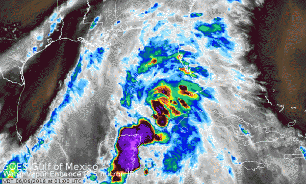
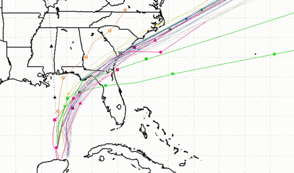
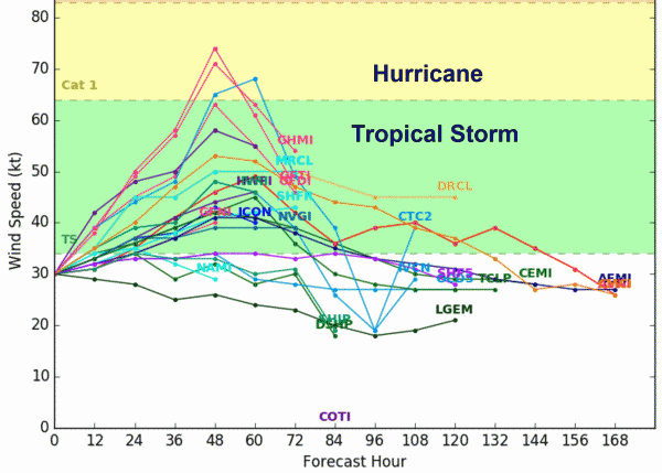
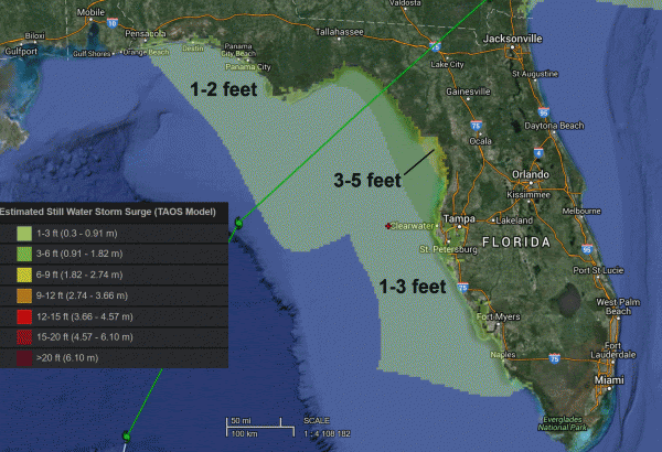
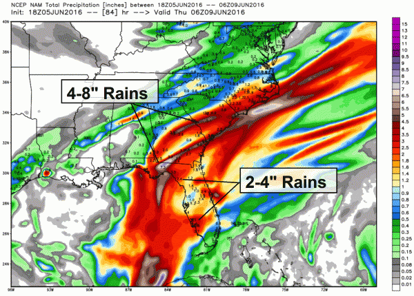
RAINFALL...Colin is expected to produce rainfall amounts
of 3 to 5 inches with isolated maximum totals of 8 inches possible
across the northeastern Yucatan peninsula, western Cuba, and
Florida.

STORM SURGE...The combination of a storm surge and the tide will
cause normally dry areas near the coast to be flooded by rising
waters.  The water could reach the following heights above ground if
the peak surge occurs at the time of high tide...

Indian Pass to Tampa Bay...1 to 3 ft with slightly higher amounts
possible in a few locations.
Tampa Bay south to Florida Bay...1 to 2 ft.

Localized coastal flooding and dangerous surf is possible along the
Florida East coast, within the Tropical Storm Watch area.

The deepest water will occur along the immediate coast.
Surge-related flooding depends on the relative timing of the surge
and the tidal cycle, and can vary greatly over short distances.  For
information specific to your area, please see products issued by
your local National Weather Service forecast office.

WIND...Tropical storm conditions are expected to first reach the
coast within the warning area by Monday afternoon.  Tropical storm
conditions are possible within the watch area by Monday.

TORNADOES...A few tornadoes are possible on Monday across portions
of Florida and far southern Georgia.
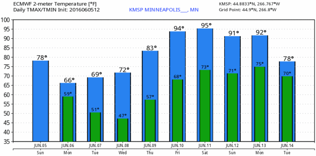
The Big Weather Story: Impending Heat. After today you may be ready to bake a little. Then again, factoring dew points in the low 70s by late week the heat index will surge into the oh-zone, maybe even the ugh-zone, possibly as high as 100F by Friday and Saturday afternoon, based on ECMWF guidance. Predicted temperatures above: WeatherBell.
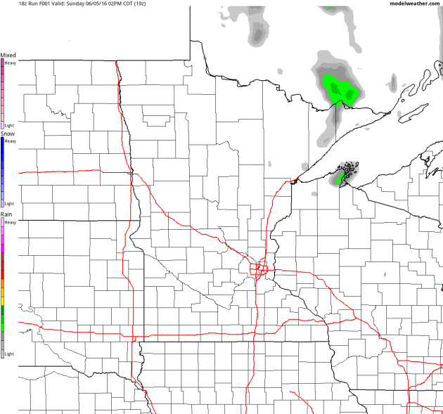
Spotty Pop-Up Showers Today. With clouds and a few instability showers sprouting temperatures may hold in the 60s across much of Minnesota today, possibly nudging 70F in the MSP metro if skies brighten for an hour or two. Future Radar: NOAA and AerisWeather.
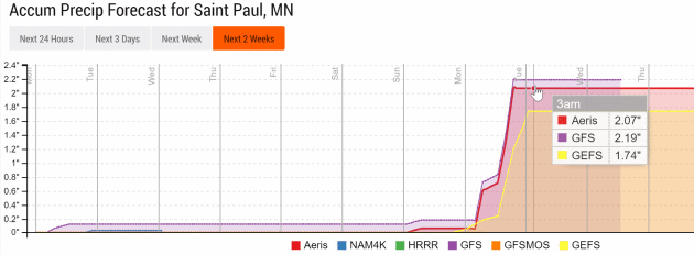
A Relatively Dry Week. Our internal model ensemble keeps us basically dry from Tuesday into Sunday, but 1-2 inches of rain may have 1 week from today as a cooler front approaches, preceded by a band of heavy rain, maybe a severe risk as well. Too early to say. Graph: Aeris Enterprise.
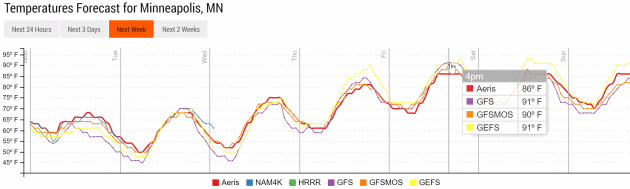
Small Cooler Advisory by Friday. NOAA models aren’t as hot as ECMWF, but GFS runs also suggest low 90s by Friday. Enjoy the cool front, within 5-6 days neighbors will be whining about the humidity. Wait for it.

Weather Forecasting Equipment “Crude” in 1966. An article at the Topeka Capital-Journal served as a wake-up call (to me) of just how far we’ve come; here’s a clip: “…Introduction of Doppler radar, satellite imagery and live video from storm chasers, as well as computer and cellphone communications, changed the game. Chad Omitt, the current NWS warning coordinator in Topeka, said real-time satellite data on where storms were developing and the diagnostic capacity of Doppler radar enhanced the opportunity to warn people. “The huge advancement in the ability to interrogate what’s happening in a thunderstorm is the ability to see the wind speed and directions,” Omitt said. “We can actually see what the winds are doing inside that storm, especially in the vicinity of where that tornado might be…”
Photo credit: “Mike Akulow, who retired in 2005 after more than 30 years with the National Weather Service in Topeka, says technology used at the time of the June 8, 1966, tornado was “very crude.” Today, GPS technology, radar upgrades and an Internet-based chat system has improved the quality and quantity of weather information available.”


WEDNESDAY: Plenty of sun, warming up. Winds: SE 5-10. Wake-up: 56. High: 77
THURSDAY: Early thunder risk, then hot sun. Winds: S 10-15. Wake-up: 63. High: 85
FRIDAY: Sizzling sun, feels like 100F late PM. Winds: SW 10-15. Wake-up: 70. High: 94
SATURDAY: Evacuate to the lake. Steamy sunshine. Winds: SW 7-12. Wake-up: 73. High: 93
SUNDAY: Hazy sun, risk of a T-shower. Winds: S 10-15. Wake-up: 72. High: 91
Climate Stories…

Editorial: Carbon Pricing Will Be a Key to Fighting Climate Change. An Op-Ed at the Canadian Trucking Alliance caught my eye; here’s an excerpt: “…As indicated above, carbon pricing is being promoted as an essential measure in the fight against climate change. There are two main forms of carbon pricing: (1) A carbon tax; or (2) A cap-and-trade system. Put simply, the difference is that the amount of GHG reduction from a carbon tax is a function of the market based on the price of fuel, whereas a cap and trade system sets an actual cap on GHG emissions and a market of tradeable credits is created where those who reduce their carbon footprint can sell the credits they receive to those who are not meeting their targets. Both have their positive and negative features, depending on your point of view. The outcome of both is – either directly (carbon tax) or indirectly (cap and trade) – an increase in fuel prices. It is argued that by placing a price on carbon, consumers of fossil fuels will economize (use less) of those fuels and seek alternative, cleaner fuels. But, the devil is always in the details…”
Global Warming is Greening Up The Far North. More tangible evidence of the changes underway, reported at Summit County Citizens Voice; here’s an excerpt: “After taking a close look at 87,000 satellite images, NASA scientists say the northern parts of Canada and Alaska are getting greener. Shrubs are sprouting in grassy tundra zones and shrubs are growing bigger and denser — changes that could have impacts on regional water, energy and carbon cycles. The new NASA study adds more detail to previous research that reached similar conclusions and could help inform climate scientists about how the changes will affect global temperatures. The study covered the timespan between 1984 and 2012. The images came from the joint NASA/U.S. Geological Survey Landsat program, which provides the longest continuous space-based record of Earth’s land vegetation in existence...”
Photo credit: “NASA scientists have detailed a widespread greening trend across Alaska and northern Canada in a new study.” Photo courtesy NASA/Ross Nelson.
From Floods to Forest Fires: A Warming Planet – In Pictures. The Guardian has the photo essay; here’s a link and story excerpt: “Droughts, floods, forest fires and melting poles – climate change is impacting Earth like never before. From the Australia to Greenland, Ashley Cooper’s work spans 13 years and over 30 countries. This selection, taken from his new book, shows a changing landscape, scarred by pollution and natural disasters – but there is hope too, with the steady rise of renewable energy…”

CBO Warns of Climate Change’s Budget Impact. Politico has the story; here’s the intro: “The Congressional Budget Office is warning lawmakers about the fiscal risks of climate change, putting the studiously non-partisan agency at odds with Republican Party orthodoxy. The report, released as hurricane season begins, warns that hurricane damage will “increase significantly in the coming decades” due to climate change. The agency added that humans are playing a role in fueling rising temperatures and a shifting climate…”
