Manatee Rescue
This poor manatee was subject to IRMA as the water receded out of Tampa Bay as Hurricane IRMA approached. A number of people helped to rescue this poor manatee as they dragged it to deeper water.

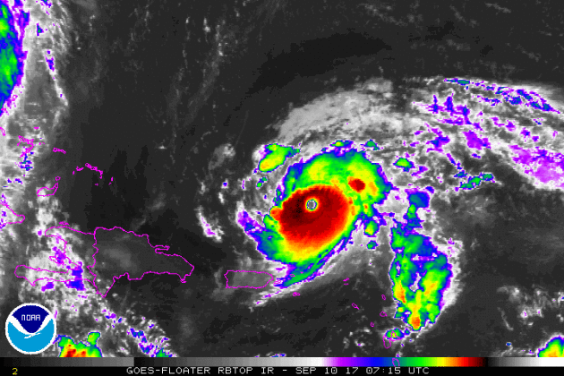
IRMA Makes Landfall As A Major Category 4 Storm
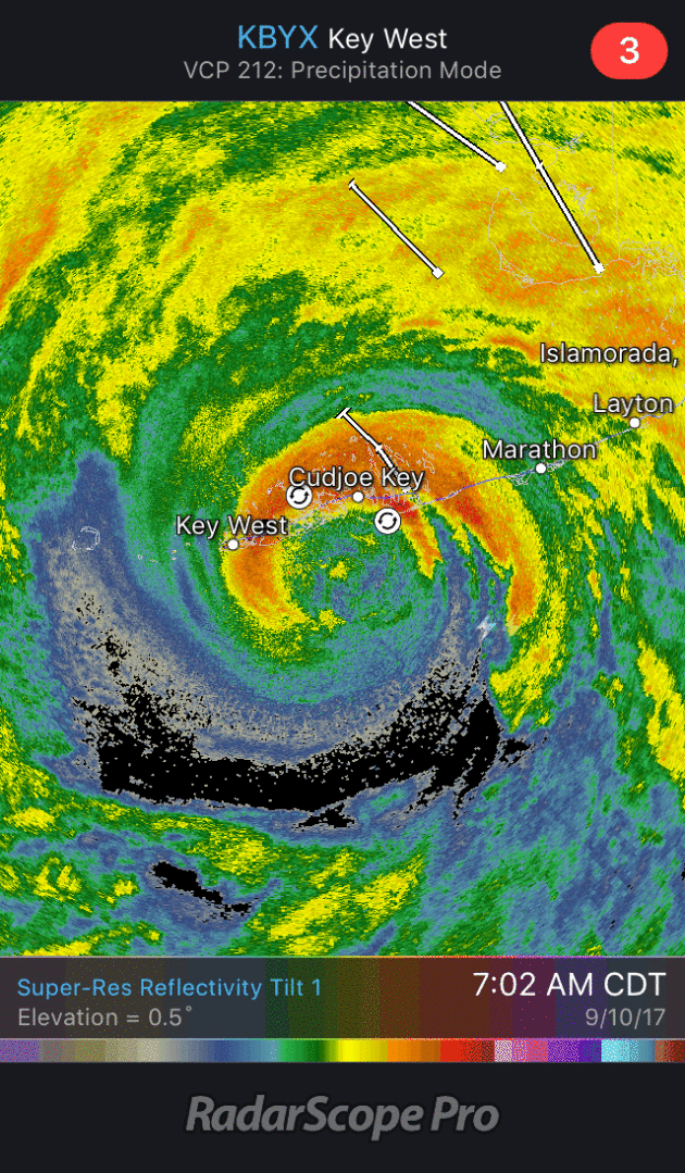
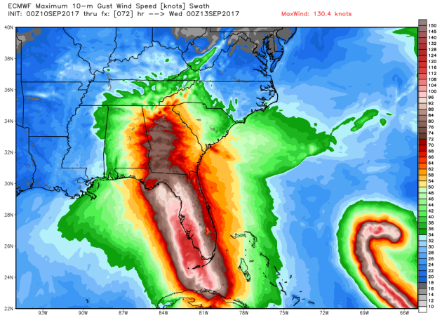
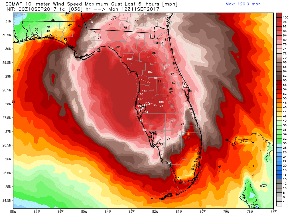
This was the radar loop from early Sunday morning as Hurricane Irma officially made landfall along the Florida Keys. After briefly dropping down to category 3 strength during the day Saturday, IRMA intensified to a category 4 storm with sustained winds of 130mph (pressure at 929mb) just before making landfall in Cudjoe Key in the Lower Florida Keys at 9:10am Sunday morning. Interestingly, NEVER on record has there been (2) Category 4 hurricanes to make U.S. landfall in one Atlantic hurricane season until now! Hurricane Irma in the Florida Keys on Sunday, September 10th and Hurricane Harvey on Friday, August 25th. At 3:35pm, there was a second landfall near Marco Island, FL as a category 3 storm with winds of 115mph (pressure at 940mb).
Satellite Loops of IRMA
.gif)
.gif)
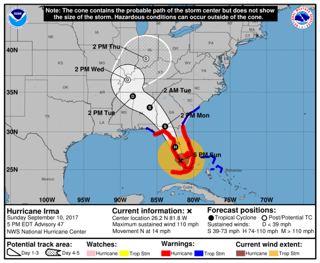
Tracking IRMA
 ________________________________________________________
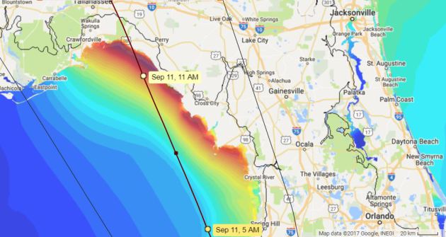
Storm Surge Forecast
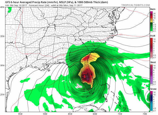
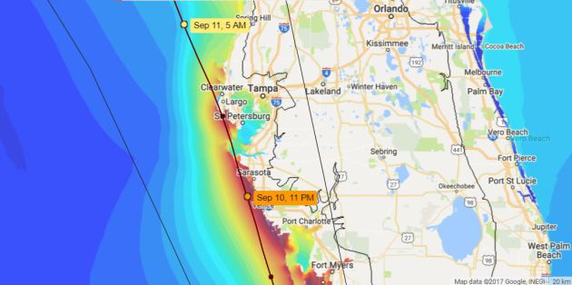
Here’s a look at the storm surge forecast from PM Sunday into Monday as IRMA scrapes the west coast of Florida. The worst case scenario would be for the storm to stay just west or right along the coast as the storm could continue to feed off of the warm Gulf of Mexico water temperatures, which would help to keep IRMA’s strength. Also, the northeast quadrant of the storm is always the worst in terms of winds, waves and storm surge, so as IRMA lifts north along the coast, the northeast quadrant of the storm will hit very vulnerable areas along the coast from Tampa to the Big Bend of Florida.
________________________________________________________________
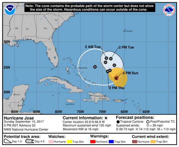
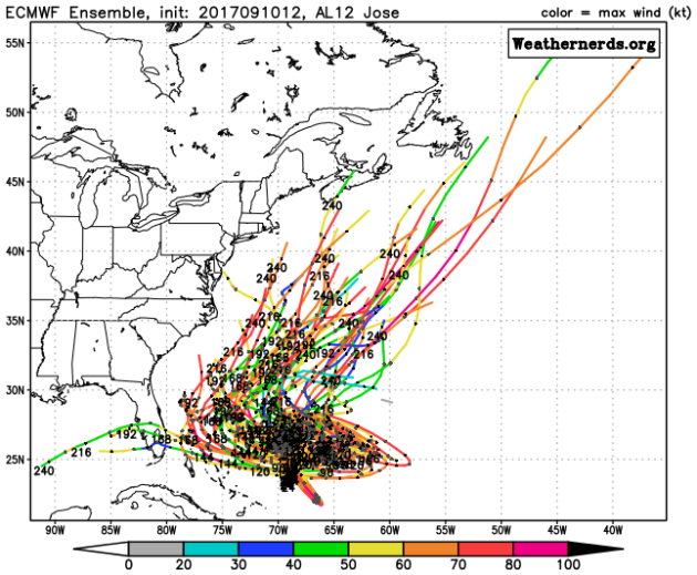
Still Tracking JOSE in the Atlantic
____________________________________________________________
.png)
__________________________________________________________
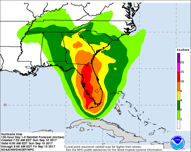
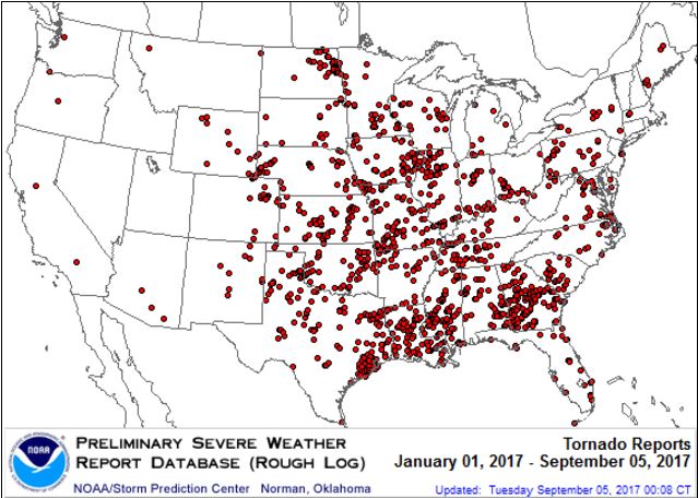
It certainly has been a fairly active first half of 2017 with 1344 preliminary tornado reports through September 9th. Note that this is the most tornadoes through September 9th since 2011, when there were 1,782 reports. The map below shows the distribution of the tornadoes so far this year.
PRELIMINARY 2017 Tornado Count
According to NOAA’s SPC, the PRELIMINARY 2017 tornado count is 1344 (through September 9th). Note that is the most active year for tornadoes since 2011, when there were 1,782 tornadoes. Keep in mind there was a major tornado outbreak in the Gulf Coast region from April 25-28, 2011 that spawned nearly 500 tornadoes, some of which were deadly. That outbreak is known as the Super Outbreak of 2011 and has gone down in history as one of the biggest, costliest and one of the deadliest tornado outbreaks in history.
.png)
_____________________________________________________________________
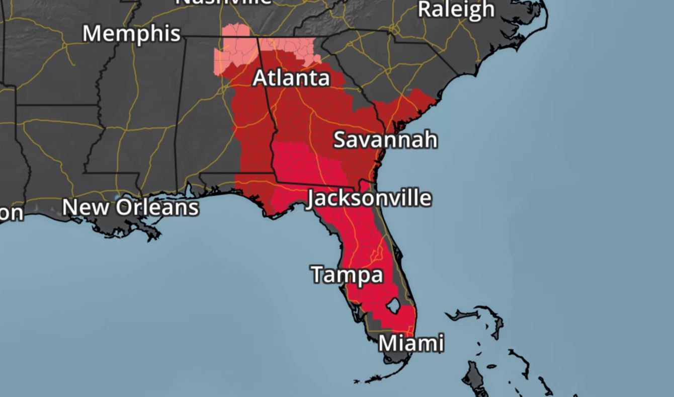
National Weather Hazards Ahead…
1.) Heavy rain from north-central portions of Florida to North Carolina and Kentucky, extending as far west as western Tennessee, Mon-Tue, Sep 11-12.
2.) Heavy rain over extreme southern portions of the Alaska panhandle, Mon, Sep 11.
3.) High winds for much of the Southeast, Mon, Sep 11.
4.) Significant waves from about Cape Canaveral, Florida, to near Myrtle Beach, South Carolina, Mon, Sep 11.
5.) Significant waves along most of the west coast of Florida, Mon, Sep 11.
6.) Flooding is occurring or imminent over far southern Florida, and near the upper Texas coast.
7.) Flooding is likely from about Lake Okeechobee, Florida, northward through most of Georgia, and adjacent parts of Alabama.
8.) Flooding is possible for portions of the Carolinas, eastern Georgia, and eastern Tennessee.
9.) Severe Drought across the Middle Mississippi Valley, the Northern Plains, the Northern Rockies, and Hawaii.
.png)
_________________________________________________________
“The unprecedented drought that’s crippling Montana and North Dakota”
It came without warning, and without equivalent. Now a flash drought is fueling fires and hurting the lives of those who work the land. When Rick Kirn planted his 1,000 acres of spring wheat in May, there were no signs of a weather calamity on the horizon. Three months later, when he should have been harvesting and getting ready to sell his wheat, Kirn was staring out across vast cracked, gray, empty fields dotted with weeds and little patches of stunted wheat. “It’s a total loss for me,” said Kirn, who operates a small family wheat farm on the Fort Peck Reservation, an area of north-eastern Montana that lies right in the heart of the extreme climatic episode. “There’s nothing to harvest.”Kirn’s story is typical across the high plains in Montana and the Dakotas this summer, where one of the country’s most important wheat growing regions is in the grips of a crippling drought that came on with hardly any warning and, experts say, is without precedent.”
See more from the Guardian HERE:
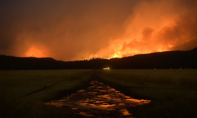
(A wildfire burns in the Lolo national forest in Montana in August. The severe drought has served as ideal conditions for continued fires. Photograph: Rion Sanders/AP via The Guardian)
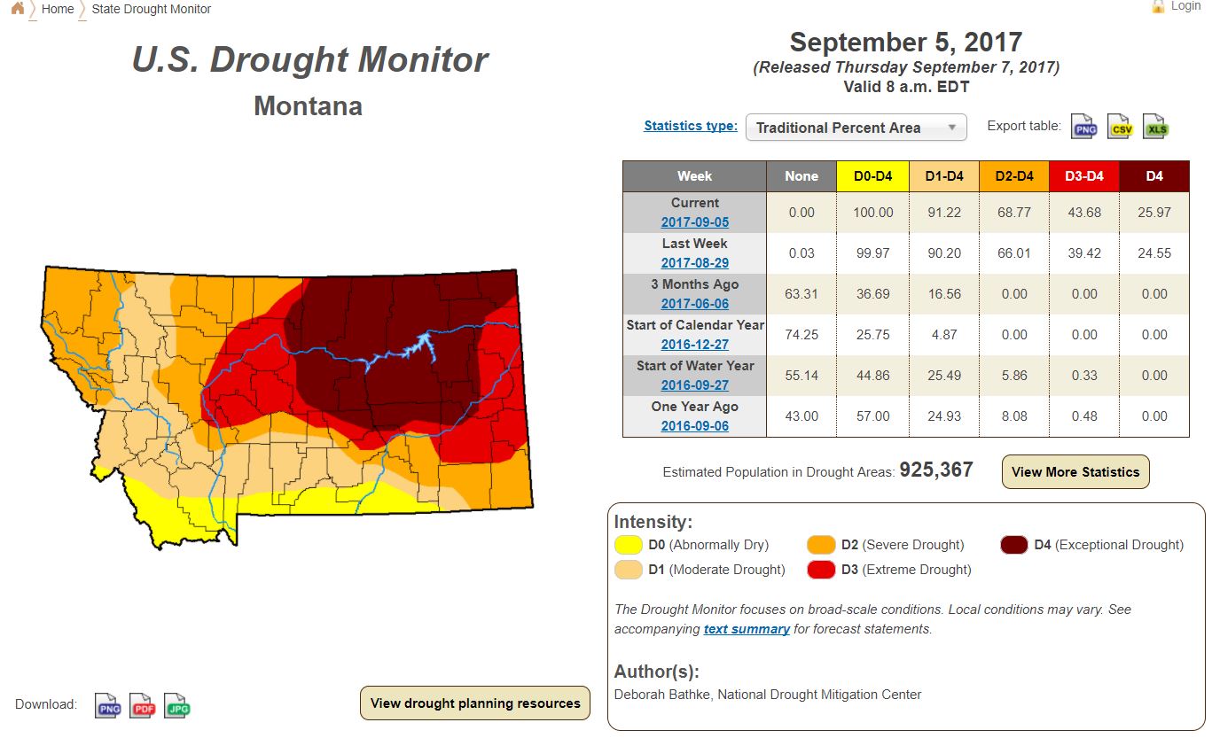
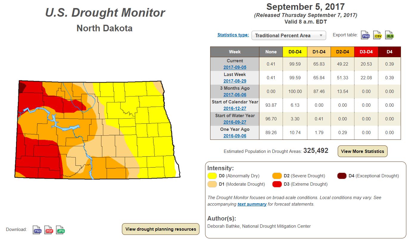
Latest Drought Monitor
Here’s the latest drought update from the US Drought Monitor, which shows EXCEPTIONAL drought conditions, which now covers nearly 26% of Montana. Note that 91% of the state is in a MODERATE drought. In North Dakota, more than 25% of the state is considered to be in an EXTREME drought.
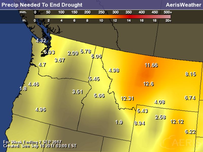
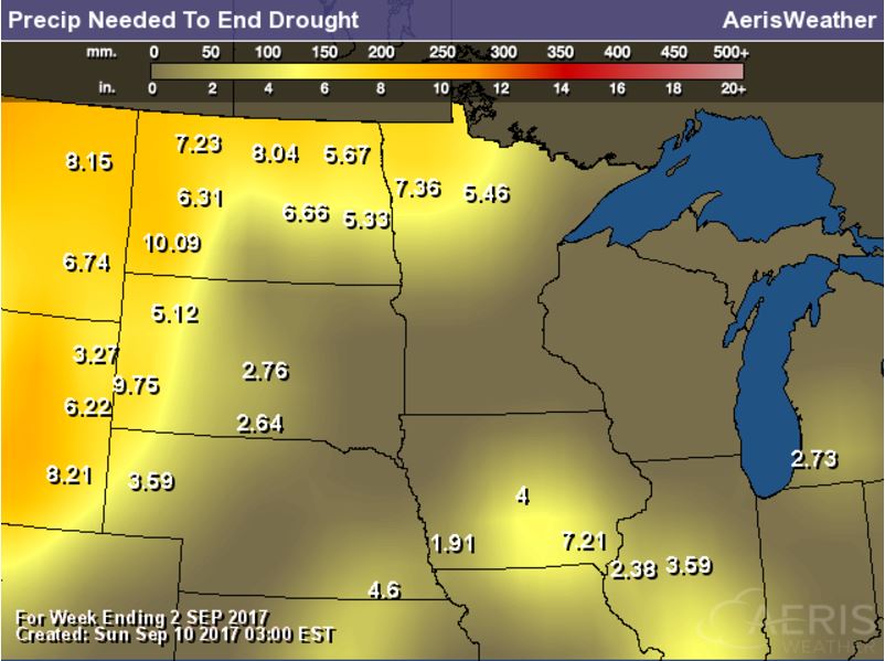
Rain Needed to End Drought
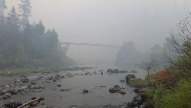
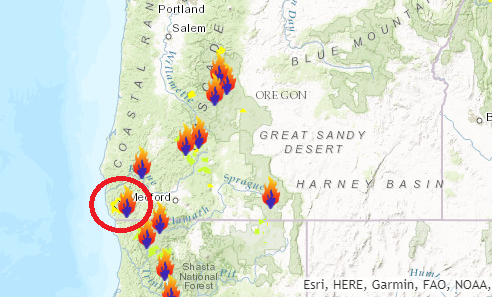
Chetco Bar Fire – 5 Miles Northeast of Brookings, OR
The Chetco Bar Fire in near Brookings, Oregon is a very large wildfire in the Western US that started on Wednesday, July 12th by lightning and has grown to more than 182,000 acres! There are more than 1,400 people working on this fire, which is only 5% contained. The estimated containment date is set for Sunday, October 15th.
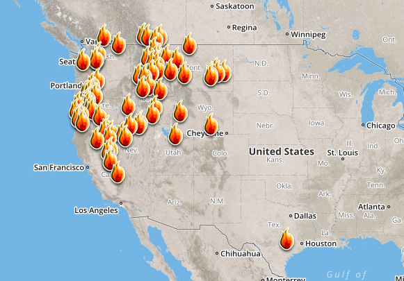
Here’s a look at the current wildfire map across the country. Continued hot and dry weather has helped to spark several wildfires across the Western US. There have even been fires popping up in the Eastern U.S., two of the larger fires are burning in Florida.
Here’s a list of all the current large wildfires from Inciweb:
National Weather Outlook
Here’s the weather outlook through the end of next week, which shows active weather conditions across Southeastern part of the country as IRMA lifts north through the region. Strong winds, heavy rain and even tornadoes will be possible through the early week. Weather conditions will also turn more active in the Western US as a storm system moves in during the 2nd half of the week.
.gif)
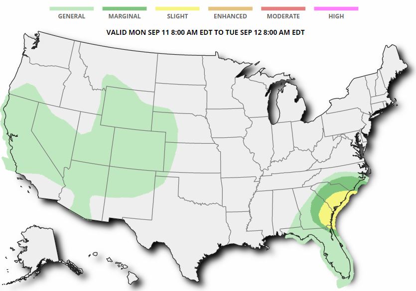
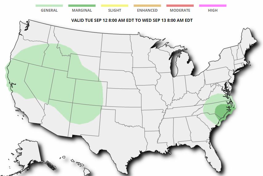
According to NOAA’s WPC, there is a MODERATE risk of excessive rain on Monday across parts of the as heavy rain from Hurricane IRMA lifts north. By Tuesday, the heaviest rainfall will likely start fading, but there is still a MARGINAL risk of heavy rainfall
.gif)
.gif)
________________________________________________________________________
By Paul Douglas
________________________________________________________________________
TUESDAY: Plenty of sun. Feels like Mid-August. Winds: E 3-8. High: 83.
WEDNESDAY: Hazy-blue sky, warmer than average. Winds: S 5-10. Wake-up: 63. High: 84.
THURSDAY: Partly sunny. Slight thunder risk. Winds: S 8-13. Wake-up: 63. High: 82.
FRIDAY: Humid. More numerous thunderstorms. Winds: S 7-12. Wake-up: 64. High: 81.
SATURDAY: Sticky with more showers, T-storms. Winds: S 10-20. Wake-up: 66. High: 83.
SUNDAY: Showers taper, cooler breeze. Winds: NW 10-15. Wake-up: 61. High: 76.
_______________________________________________________
This Day in Weather History
September 11th
1980: 3.35 inches of rain fall in St. Cloud.
1942: A line of thunderstorms races across Minnesota at 70 mph, producing severe winds that would destroy 651 barns in a 30 mile wide, 180 mile long path.
1931: The daytime high in St. Cloud was 96 degrees.
1931: Summer still has its grip on Minnesota, with a high of 111 degrees at Beardsley.
1900: The soggy remains of the Galveston Hurricane bring 6.65 inches of rain to St. Paul over two days.
1807: Thick smoky weather is noted at Pembina.
________________________________________________________
Average High/Low for Minneapolis
September 11th
Average High: 74F (Record: 96F set in 1931)
Average Low: 55F (Record: 35F set in 1962)
Record Rainfall: 3.11″ set in 1900
_________________________________________________________
Sunrise/Sunset Times for Minneapolis
September 11th
Sunrise: 6:47am
Sunset: 7:31pm
Hours of Daylight: 13hours & 08mins
Daylight LOST since yesterday: ~3 minutes and 4 seconds
Daylight LOST since summer solstice (June 20th): ~2 hours & 54 minutes
__________________________________________________________
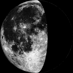
Moon Phase for September 11th at Midnight
1.0 Days Before Last Quarter
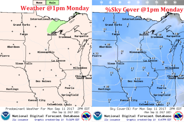
Monday will be a fairly mild day with highs in the 70s and 80s across much of the state. Dewpoints will also be a bit sticky as many get into the 60s
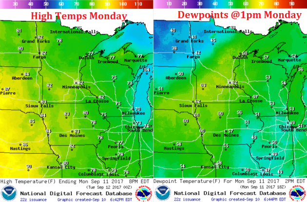
Weather Outlook For Monday
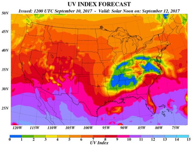
UV Index for Monday – HIGH
The UV Index for Monday will be HIGH, which means that it will only 20 to 30 minutes or less to burn unprotected skin. With that said, if you are planning on spending any extended length of time outside, make sure you wear appropriate attire and lather on the sun block!
__________________________________________________________________________
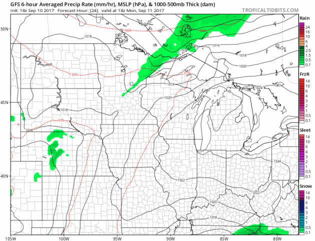
Rainfall Potential Ahead
.png)
______________________________________________________
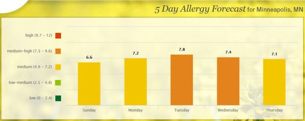
Pollen Forecast
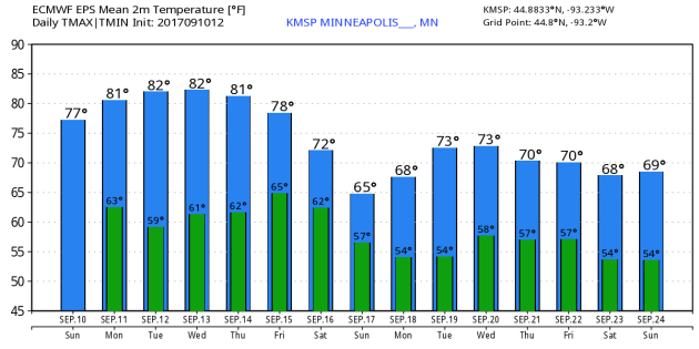
Minneapolis Temperature Outlook
Here’s the temperature outlook through September 24th, which shows temps warming into the 80s this week, but will fall into the 60s and 70s as we head into the 2nd half of the month.
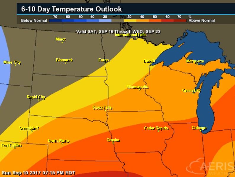
According to NOAA’s CPC, the extended temperature outlook from September 16th through the 20th suggests warmer than average temperatures settling back in across much of the Midwest, Great Lakes and Central part of the country.
___________________________________________________________
Extended Temperature Outlook
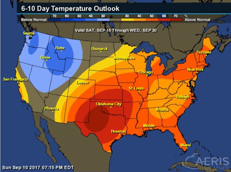
According to NOAA’s CPC, the extended temperature outlook through September 20th shows that a good chunk of the Eastern and Southern U.S. will be warmer than average, but the Northwestern US will remain cooler than average.
 __________________________________________________________
5 Day Precipitation Outlook
According to NOAA’s WPC, the next several days could produce areas of locally heavy rainfall across parts of the Southeastern and Northwestern US. The remnants of IRMA will continue to push through the Southeast through the first part of the week. The next system moving into the Western US will produce areas of 1″ to 2″ rainfall tallies. Note that some of the heaviest will be found in Montana, where they really need it!
.gif) ___________________________________________________________________
___________________________________________________________________
