Afterglow
Talk about a meteorological disconnect. Today the sun will struggle as high into the southern sky as it was back on February 28, when the max temperature in the Twin Cities was a brisk 14F, after waking up to a crisp -9F.
Today will be nearly 50 degrees warmer. Why the radical difference? No snow on the ground yet is good for 20-30 degrees. Water retains warmth faster than land; a subsequent “lag” in the atmosphere applies a temperature break to an inevitable temperature tumble. And autumns have been trending milder/longer; safe ice on most Minnesota lakes has been delayed until December.
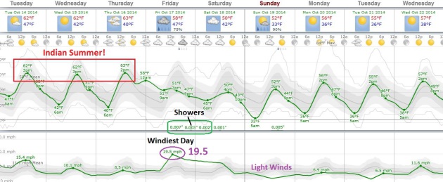
Nothing even remotely wintry is shaping up the next 2 weeks; a more zonal, west to east steering wind aloft keeping us milder than average into late October. Temperatures top 60F from today into Thursday. After cooling off this weekend long-range guidance hints at more 60s late next week. The weather will cooperate with harvest, fall clean-up and power-raking in the days to come.
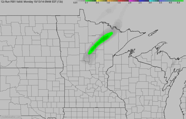
Today’s storm pinwheels just to our east, soaking Wisconsin; a chance of windblown rain showers by late Friday.
Autumn in Minnesota is an Immersive IMAX 3-D Sensation. And we’re all invited to the premiere.
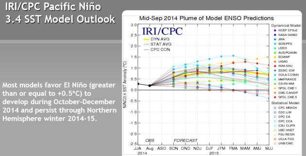
Odds Still Favor El Nino. A warming of the equatorial Pacific usually correlates with less severe winters for Minnesota and the Upper Midwest. Usually. The west coast ridge appears to finally be breaking down; that could mean a more zonal, progressive flow – with lower odds of a stationary blocking pattern capable of a perpetual Polar Vortex dipping into the USA. We’ll see. More details than you ever wanted to see on the developing El Nino from NOAA CPC.

Time For Your Brazilian Model. The AGCM Ras model, courtesy of Brazil’s National Weather Service, shows a (very) warm bias from December into February, evidence of a “Rex Block” setting up across North America, favoring stormy weather over the Pacific Northwest and New England, with a relatively mild ridge of high pressure over the midsection of the USA. No, I wouldn’t place a big bet on this forecast, but I still have a strong hunch the upcoming winter won’t look anything like last winter.
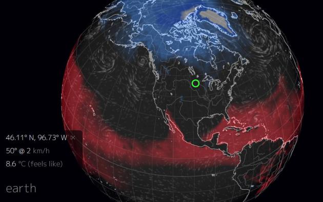
Global Misery Index. Here’s a snapshot of todayy’s extremes across North America; significant wind chill showing up in blue, a high heat index in red. Large north-south temperature contrasts in October can whip up very significant, full-latitude storms (like what’s pushing across the Mississippi Valley toward the East Coast). Map: earth.nullschool.net.
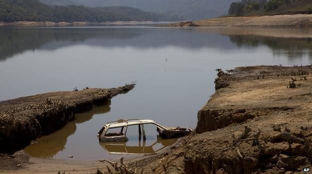
Brazil Drought Crisis Deepends in Sao Paulo. Much of Central and South America is experiencing drought conditions; here’s an excerpt from The BBC: “The governor of the Brazilian state of Sao Paulo has asked for emergency clearance to siphon the remaining water out of the main reservoir serving Sao Paulo city, which has almost run dry. After nine months of unprecedented drought, 95% of the water has gone. Geraldo Alckmin, re-elected in last week’s elections, has been criticised for not imposing water rationing to tackle the crisis. Twenty-nine other Brazilian cities have been affected by the drought...” (Photo: AP).

Flash Flood Chaser. This is a new one. There are thousands (?) of tornado chasers, professionals and amateurs, hurricane chasers, even people who try to put themselves in the path of a developing blizzard. But flash flooding? That requires a level of patience I can only dream of. Here’s an excerpt of a wild story at High Country News: “…Sometimes, after waiting four hours in 95 degree heat with nothing for company but a CamelBak and his own thoughts, Rankin begins to wonder: “Am I just hoping for the impossible?” A trail sign rattles in the wind; nothing moves. And then, finally, he hears a soft rumbling in the distance. The banks of the dry wash tremble underfoot. Just as he catches a wafting scent of fresh, wet, gritty earth, the flood rolls around the corner, gnashing and crunching at an unmistakable pitch. It’s laden with debris carved from miles of canyon and riverbed, black as solidified lava and thick as wet cement. But instead of fleeing from the deadly flow, Rankin leans in closer to film it, sometimes hopping to high ground just as the water lips over his shoes…”


TODAY: Partly sunny and windy. Winds: N 15-25 High: 62
TUESDAY NIGHT: Clear and cool. Low: 42
WEDNESDAY: Plenty of mild sun, milder than average. High: 64
THURSDAY: Fading sun. Last day of Indian Summer this week. Wake-up: 41. High: 66
FRIDAY: Windy, cooler with PM showers. Wake-up: 50. High: 55
SATURDAY: Mostly cloudy and brisk. Wake-up: 40. High: 52
SUNDAY: More sun, a bit milder. Wake-up: 34. High: 58
MONDAY: Blue sky, not bad for October 20. Wake-up: 36. High: near 60
Climate Stories…

Hagel To Address “Threat Multiplier” of Climate Change. Here’s an excerpt of a story at defense.gov:“….Uncertainty is no excuse for delaying action. “While scientists are converging toward consensus on future climate projectons, uncertainty remains. But this cannot be an excuse for delaying action,” Hagel said. “Every day our military deals with global uncertainty. Our planners know that, as military strategist Carl von Clausewitz wrote, “all action must, to a certain extent, be planned in a mere twilight.” It is in this context, he said, that he is releasing DoD’s Climate Change Adaptation Roadmap today….”
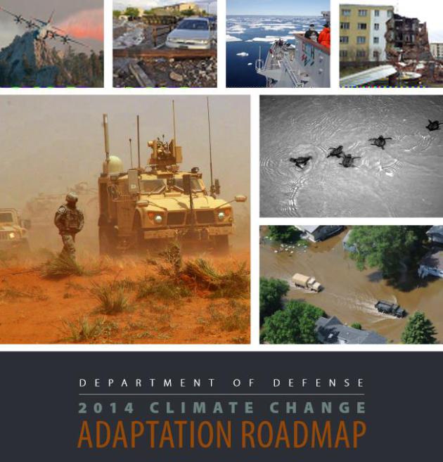
Department of Defense 2014 Climate Change Adaptation Roadmap. In fairness, the Pentagon has recognized the risk posed by climate change since the late 90s. What is different about the 2014 report is the sense of urgency. The term “immediate threat” is invoked twice in the first 4 paragraphs. That is new. The 20-page PDF from the DoD is here.


Pentagon Unveils Plan For Military’s Response to Climate Change. Here’s a clip from a story at The Los Angeles Times: “…The Pentagon’s “2014 Climate Change Adaptation Roadmap” describes how global warming will bring new demands on the military. Among the report’s conclusions: Coastal military installations that are vulnerable to flooding will need to be altered; humanitarian assistance missions will be more frequent in the face of more intense natural disasters; weapons and other critical military equipment will need to work under more severe weather conditions...”
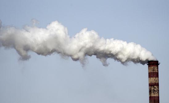
What Would Milton Friedman Do About Climate Change? Tax Carbon. Here’s an excerpt from a story at Forbes: “…What’s happening when we turn on the lights, when the power is derived from a coal plant, or when we drive our car, is that carbon dioxide is emitted into the air, and that’s sprinkling around damages in Bangladesh, London, Houston,” said Michael Greenstone, the Milton Friedman Professor of Economics at the University of Chicago and the director of the Energy Policy Institute of Chicago. “And those costs are real, and they’re not being reflected in the costs of that electricity or the tank of gas. Emitting carbon dioxide into the atmosphere does allow you to produce electricity more cheaply, but there’s a whole other set of people who are being punished or penalized. It’s a poor idea of economics...”
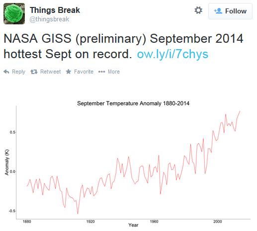
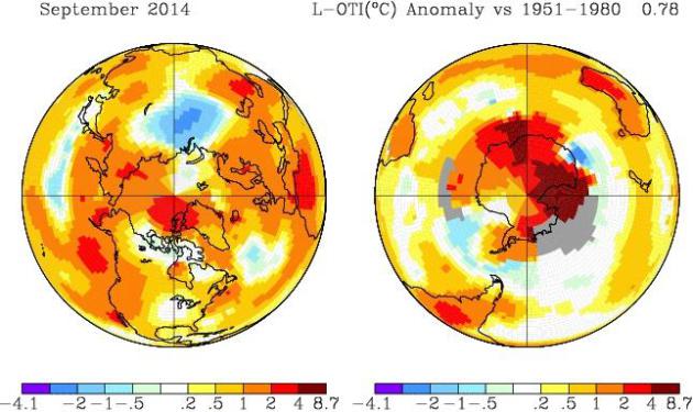
Simmering September. It’s not official, but it would appear, based on NASA GISS data that after the warmest August on record, worldwide, September may also have the distinction of being the warmest on record. Check out the temperature anomalies over Antarctica above, as much as 4-9C warmer than average.
* Preliminary NASA GISS data suggests that 2014 (January – September) is the 3rd warmest on record, worldwide.
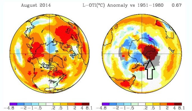
After Record Heat in August. August was the warmest ever observed over global land and water, according to NASA GISS. Once again look at the temperature anomalies over the West Antarctic Ice Sheet.
