80s In Late October!
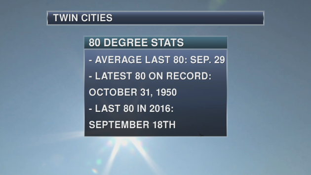
The forecast high right now for Friday is 80 in the Twin Cities! If the Twin Cities did hit 80 on Friday, it would be one of the latest last 80s on record as only ten other years have had a later date that the last 80 occurred on. The last average 80 on record (looking over the entire Twin Cities record) occurs on September 29th. Meanwhile, it was quite a warm Halloween in 1950 as that is the date of the latest 80 on record. Last year, the last 80 was on September 18th. The last time we saw a high that was 80 or higher this year was back on September 24th when the high reached 90.
_______________________________________________
August In October With A High Of 80 Today!
Who’s ready to get a natural sun tan in late October?
After a beautiful week of weather so far, today looks to potentially be the best day of the stretch – if you don’t mind breezy weather, that is. Highs will climb into the upper 70s to around 80 later this afternoon on the back of mainly sunny skies and southerly winds that’ll gust up to 30 mph.
To put today into perspective, it’s not often that we hit 80 this late in the year. Even though the record for the day is 83 set in 1953, if we reached 80 today in the Twin Cities it would be the eleventh latest last 80 degree day on record!
Unfortunately, this nice stretch of weather comes to an end this weekend. A cold front brings showers and storms for Saturday, along with cooler conditions. A second front early next week ushers in highs that will finally be back around average for late October.
Make an effort to get out and enjoy the weather today. There’s probably a good chance we won’t see weather this nice again until next spring.
_______________________________________________
Extended Twin Cities Forecast
FRIDAY: Warm and windy. High 80. Low 61. Chance of precipitation 10%. Wind S 10-25 mph.
SATURDAY: Cooler with showers and thunderstorms. High 69. Low 46. Chance of precipitation 80%. Wind S 10-15 mph.
SUNDAY: Sunny skies. Highs still above average. High 62. Low 46. Chance of precipitation 10%. Wind NW 3-8 mph.
MONDAY: A few afternoon showers. High 62. Low 43. Chance of precipitation 30%. Wind SW 5-10 mph.
TUESDAY: Breezy with cooler temperatures. High 52. Low 36. Chance of precipitation 20%. Wind NW 10-15 mph.
WEDNESDAY: Frosty start. Cool sunshine. High 54. Low 40. Chance of precipitation 10%. Wind NW 5-10 mph.
THURSDAY: A few clouds. Highs around average. High 54. Low 39. Chance of precipitation 10%. Wind SW 5-10 mph.
_______________________________________________
This Day in Weather History
October 20th
2002: Heavy snow impacts central Minnesota. It fell in a 10-20 mile wide band from southeast North Dakota to around Grantsburg, Wisconsin. Little Falls picked up 9 inches.
1916: Accumulating snow falls in south central Minnesota with 4.5 inches recorded in New Ulm, 4 inches in Farmington and Hutchinson, 3.5 inches in Montevideo, and 3 inches in Faribault.
1835: 6 inches of snow falls at Ft. Snelling.
_______________________________________________
Average Temperatures & Precipitation for Minneapolis
October 20th
Average High: 56F (Record: 83F set in 1953)
Average Low: 38F (Record: 18F set in 1960)
Average Precipitation: 0.07″ (Record: 2.64″ set in 1934)
________________________________________________
Sunrise/Sunset Times for Minneapolis
October 20th
Sunrise: 7:35 AM
Sunset: 6:19 PM
*Length Of Day: 10 hours, 43 minutes and 28 seconds
*Daylight Lost Since Yesterday: ~2 minute and 58 seconds
*Latest Sunrise Before Daylight Saving Time Ends: November 4th (7:56 AM)
*Next Sunset At/Before 6:00 PM: November 1st (6:00 PM)
_______________________________________________
Minnesota Weather Outlook
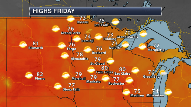
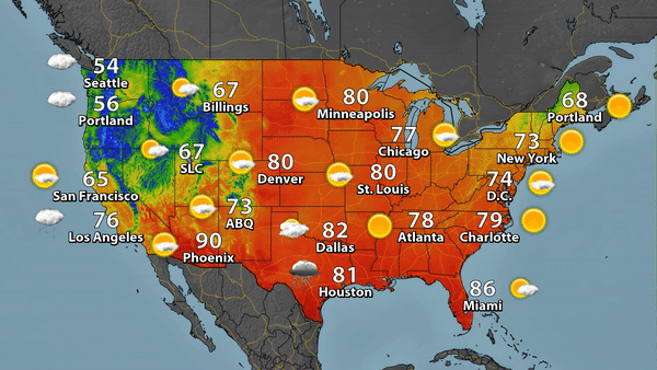
Enjoy this glorious weather day across the state, as most areas will climb into the 70s for highs. Some areas of southern Minnesota, including the Twin Cities, could see a high of 80. A few passing clouds will be possible, otherwise expect mainly sunny skies.
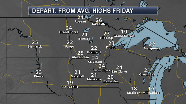
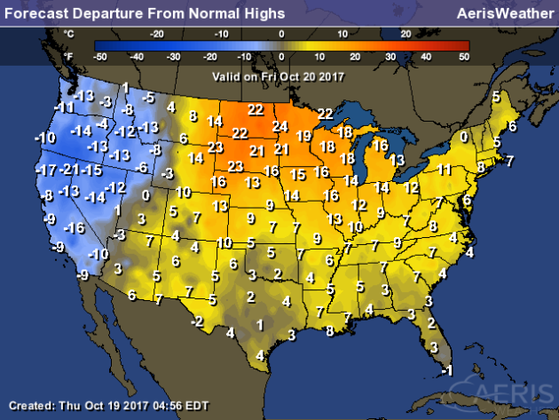
Highs on Friday will be a good 20-25 degrees above average for this time of year across the state. Enjoy it while it lasts!
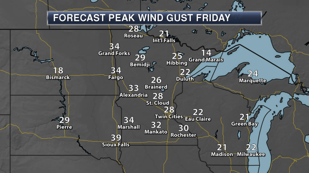
It will be quite a windy day on Friday as well, however, as winds gust over 30 mph across portions of central and southern Minnesota. That will be helping to usher in some of that warmer air, however.
Again, enjoy the warmth today while it lasts, as it could be the warmest we will be until next spring. Temperatures will take a tumble behind a couple cold fronts – one Saturday and another early next week – and be back around average for this time of year (in the 50s) by Tuesday.
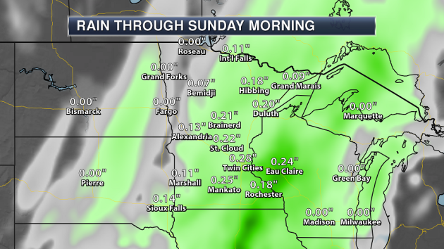
That cold front moving through Saturday will bring some showers and storms with it. Many areas of southern, central and eastern Minnesota will pick up less than a quarter inch of rain Saturday.
Another chance of rain will exist next week as the second cold front moves through, but the rest of next week looks dry at the moment after that._______________________________________________
National Weather Outlook
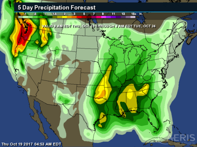
Heavy precipitation will continue across the Northwest as we watch a number of systems move through the region. Rainfall totals could top a half a foot in spots through next Tuesday morning. Heavy rain of at least 2″ will also be possible across the Plains into the Southeast from this weekend into early next week.
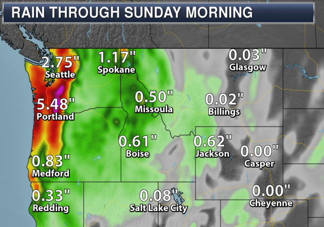
Rainfall could quickly add up in the Northwest as we head into the weekend. The forecast has Portland, OR, picking up almost five and a half inches of rain through Sunday morning!
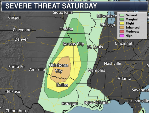
As a cold front moves through the central United States this weekend, we will watch for the potential of severe weather. An Enhanced Risk of severe weather is in place from southern Kansas to northern Texas. As storms pop in the evening, large hail and damaging winds will be the main threats, although an isolated tornado can’t be ruled out.
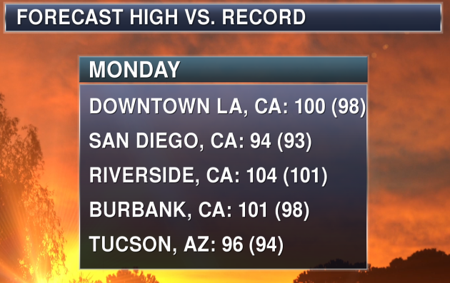
As a ridge builds out west this weekend into early next week, heat will build across portions of the Southwest. By Monday, places like Los Angeles, San Diego and Tucson could see temperatures approaching – if not breaking – records.
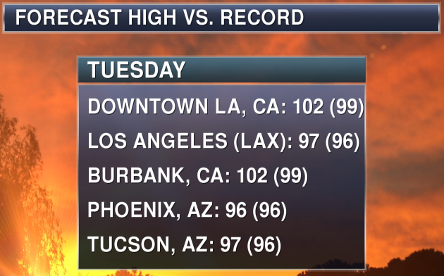
Record heat will continue into Tuesday as well, with areas like Los Angeles, Phoenix and Tucson potentially breaking records.
_______________________________________________
NOAA Winter Weather Outlook
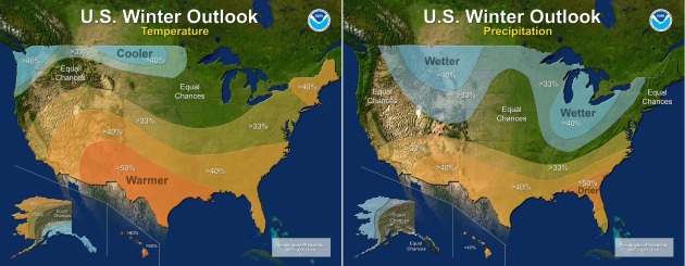
NOAA released their winter weather outlook Thursday morning, and the forecast calls for wetter and cooler than average conditions across the northern United States, but warmer and wetter conditions for southern states. More from NOAA: “Forecasters at NOAA’s Climate Prediction Center released the U.S. Winter Outlook today, with La Nina potentially emerging for the second year in a row as the biggest wildcard in how this year’s winter will shape up. La Nina has a 55- to 65-percent chance of developing before winter sets in.”
Heat In Bangladesh

Scientists believe they can predict a heat wave in Bangladesh as soon as several weeks in advance and want to set up a warning system for the country – however, a heat wave definition has to be made first. More from the IRI: “Hannah Nissan, a postdoctoral research fellow at the International Research Institute for Climate and Society, is trying to fill in this information gap. Nissan is the lead author on a new paper that proposes a heat wave definition Bangladesh – a first step towards the creation of a heat warning system in a country that currently doesn’t have heat wave forecasts. Before defining a heat wave, however, Nissan and her colleague Katrin Burkart at Columbia University’s Mailman School of Public Health first examined the health impacts of heat in Bangladesh. They found that heat waves do indeed lead to more deaths in the country. They estimated that during an eight-day heat wave in 2008, for example, at least 3,800 people died from the excess heat. Two-thirds of those killed were 65 or older, indicating that the elderly are especially vulnerable to heat waves.” (Image: Dhaka, Bangladesh. Flickr: mariusz kluzniak.)
World Hunger On The Rise
A recent U.N. report says that world hunger is on the rise again, and climate change has a hand in it. More from The Conversation: “Around the globe, about 815 million people – 11 percent of the world’s population – went hungry in 2016, according to the latest data from the United Nations. This was the first increase in more than 15 years. Between 1990 and 2015, due largely to a set of sweeping initiatives by the global community, the proportion of undernourished people in the world was cut in half. In 2015, U.N. member countries adopted the Sustainable Development Goals, which doubled down on this success by setting out to end hunger entirely by 2030. But a recent U.N. report shows that, after years of decline, hunger is on the rise again.”
Solar Power, A California Town… And A Republican
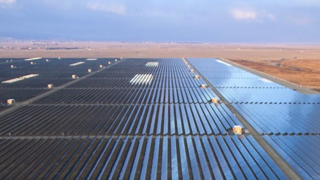
The city of Landcaster, CA, produces more solar power per capita versus any other city in the state. Oh, and did we mention this was at the backing of a Republican mayor? More from ThinkProgress: “Some cities were hit hard by the Great Recession. Lancaster, California was positively clobbered. In the summer of 2009, the unemployment rate reached 17 percent, housing prices bottomed out, and foreclosures were rampant. Since then, the city has turned things around, thanks in part to the efforts of three-time Republican mayor Rex Parris, who transformed Lancaster into a clean energy powerhouse. Parris has been described by critics as “an arrogant bully and an unstoppable control freak,” according to the Los Angeles Times, but he gets results.” (Photo: THE ALPINE SOLAR GENERATING FACILITY IN LANCASTER, CALIFORNIA. CREDIT: BUSINESS WIRE)
Wildfires, Hurricanes… The Climate Connection
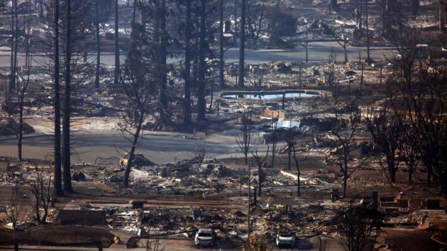
The Los Angeles Times takes a look at all the recent extreme events across the country and how they could be connected to climate change: “California is contending with some of the deadliest fires in state history as wildfires burn across the western United States. Meanwhile, four hurricanes — Harvey, Irma, Maria and Nate — have made landfall in the U.S. this year, the first time in more than a decade that so many have done so. Extreme events have been hitting the the country from all sides. To what extent does climate change influence them?” (Image: A scene of widespread devastation caused by wildfires in Sonoma County. Climate change makes fires more likely, for a variety of reasons. (Genaro Molina / Los Angeles Times))
Forest CO2 Emissions
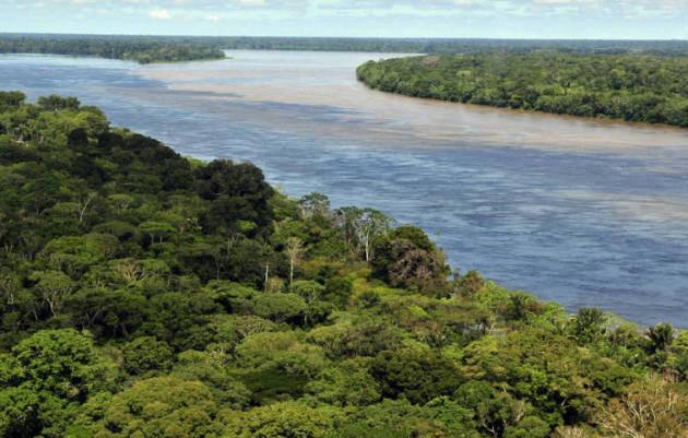
Where did the surge in CO2 during the last El Nino come from? InsideClimateNews has the answer: “During the last El Niño, global average temperatures spiked to more than 1 degree Celsius above pre-industrial levels for the first time on record, and carbon dioxide levels increased at a record pace. Now, scientists working with data from a carbon-tracking satellite have figured out where most of that CO2 surge came from. The source was three massive tropical forest regions, in different parts of the world, that each responded to the rising temperatures in a very different way” (Image: The Amazon and the tropical forests of Africa and Indonesia each responded to 2015’s high temperatures in a way that played a role in rising carbon dioxide emissions. Credit: Neil Palmer/CIAT)
_______________________________________________
Thanks for checking in and have a great Friday! Don’t forget to follow me on Twitter (@dkayserwx) and like me on Facebook (Meteorologist D.J. Kayser)!
– D.J. Kayser

