“Correction does much, but encouragement does more.” – Johann Wolfgang Von Goethe
79 F. high in the Twin Cities Friday.
84 F. average high on July 18.
94 F. high on July 18, 2013.
July 18 in Minnesota Weather History:
2000: A National Weather Service cooperative observer south of Tower reported a morning low of 29 degrees. Embarrass reported 31 degrees.
1987: The town of Floodwood lives up to its name with nearly 6 inches of rain in two days.
Extra Aqua
It’s been a curious summer.
I’ve developed a new exercise routine: dock-raising calisthenics, followed by aerobic basement-mopping and vacuuming.
According to the National Weather Service 2014 is still the wettest year on record, to date, in the Twin Cities.
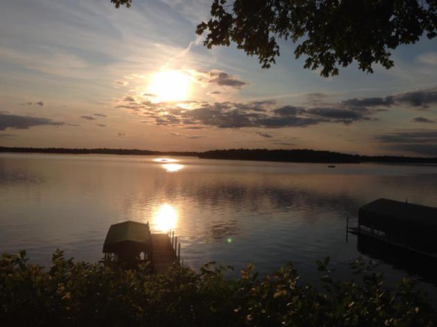
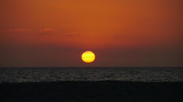
For fun? I put on waders to ford my flooded lakeshore and sit in my boat. It’s the one with the cobweb racing stripe. OK, it’s more floating than boating. In the evening I watch a cherry-red sun slip below the northwest horizon and marvel at the massive gunmetal-gray smoke plume high overhead.
Canada’s Interagency Fire Center reports total acres burned more than 6 times the usual number, which may be unprecedented looking back 10,000 years.
The same surreal jet stream pattern that brought June floods and 35F to Brimson, Minnesota Wednesday morning is sparking 80s and lightning strikes near the Arctic Circle. The 7-Day calls for smoke, heat & storms.
Monday may be the hottest day yet this summer: low to mid 90s possible, with another swarm of jungle-like downpours (and potentially severe thunderstorms) by Tuesday, especially central and northern Minnesota.
A stray T-shower may bubble up for today’s Aquatennial Events in Minneapolis. Sunday should be the sunnier, drier day to enjoy a smoky sunset, served medium rare.
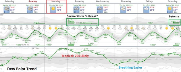
Extended MSP Meteogram. European model guidance suggests Sunday will be the warmer day of the weekend, with temperatures probably peaking Monday afternoon in the low 90s. A stray T-shower can’t be ruled out today along the leading edge of this next sticky airmass, but Tuesday looks like the most volatile day with a possible severe storm outbreak, followed by a slight dip in dew point the middle of next week.
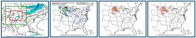
Tuesday Severe Storm Outbreak? Leveraging CIPS Analog Threat Guidance from Saint Louis University confirms my theory that Monday night into Wednesday morning of next week may be a very active period for locally heavy rainfall and a potential severe T-storm outreak as a surging warm front, high dew points and significant instability combine with ample wind shear aloft. I would bet a stale bagel we’ll see severe storm watches and warnings next Tuesday.
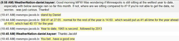
2014: Still Wettest Year for MSP, To Date. Meteorologist D.J. Kayser confirmed with the local Twin Cities National Weather Service that it’s still the soggiest year on record, to date, looking back to 1871. 27.65″ of precipitation as of July 18, even wetter than 1965 and 2013.
Record Cool Spell for Mid-July. There was no confirmed frost up north Wednesday morning, but we came very close. Dr. Mark Seeley highlights some of this past week’s weather oddities, specifically the record cool spell that swept southward out of Canada Monday into Wednesday. Here’s a highlight of this week’s Minnesota WeatherTalk: “…The cold air took residence for about 48 hours and brought new record cold mean daily temperatures (average of the maximum and minimum values for the day) to many communities on Tuesday, July 15th. Some of these records include: 55 F at Pipestone; 57 F at Windom; 58 F at Waseca and Grand Meadow; 59 F at Zumbrota, Austin, and Winnebago; and 60 F at Rochester. Finally, clear skies, high pressure, and calm winds brought some record minimum temperature values on Wednesday morning to northern and western parts of Minnesota. Some of the new records included; 35 F at Brimson; 38 F at Hibbing (tied 2007); 39 F at International Falls, Silver Bay, Crane Lake, Eveleth, and Orr; 45 F at Wheaton; and 46 F at Marshall and Worthington…”

Worst Wildfire Season in Decades in Canada’s Northwest Territories. It’s the source of the milky-white pall of smoke drifting over Minnesota and much of the rest of the USA. Alaska’s Dispatch News has the article; here’s an excerpt that caught my eye: “…According to the Canadian Interagency Forest Fire Center, there have been 31 new fires in the past 24 hours across Canada, over 2,500 so far this year and well over 2.47 million acres burned to date, early in the season. According to Flannigan, in recent years, about 8,000 fires burn about 4.9 million acres of land each year in Canada. That’s about double the annual average of just 40 years ago, he says. Canada’s senior climatologist, Dave Phillips, says the southern Northwest Territories is experiencing the hottest, driest summer in some 50 years...”
Photo credit above: “This Tuesday, July 15, 2014 aerial photo provided by Canada’s Wildfire Management Branch shows the Mount McAllister wildfire in the northeastern region of the British Columbia province of Canada. An evacuation order has been issued for the District of Hudson’s Hope in northeastern British Columbia ahead of the wildfire which is threatening the community of about 1,150 residents.” (AP Photo/The Canadian Press, B.C. Wildfire Management Branch).
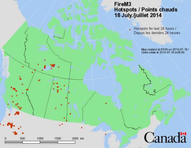
Fire Hotspots. Hundreds of fires are burning from the Pacific Northwest into much of western and northern Canada, in response to record heat and drought. The Canadian Wildland Fire Information System has the location of the most significant wildfires.
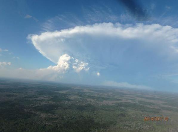
Erratic Polar Jet Stream Contributing to Historic Fires Across Canada & Siberia? Robert Scribbler has a very interesting post, focusing on the severity and aerial extent of fires raging unusually far north for July. Is polar amplification, triggered (in theory) by rapid Arctic warming, a factor? Here’s an excerpt: “…According to reports from Canada’s Interagency Fire Center, total acres burned to date are more than six times that of a typical year. A rate of burning that, according to a recent scientific study, is unprecedented not just for this century, but for any period in Canada’s basement forest record over the last 10,000 years...”
Photo credit above: NWT Fire Facebook.
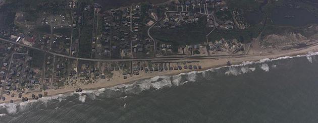
Seeing Things More Clearly. NOAA’s National Ocean Service has a story about how the agency used a new technique for obtaining aerial photographs in the wake of Hurricane Arthur, and why this is a step forward. Here’s an excerpt: “…These missions marked the first time that surveyors collected oblique imagery, or images taken at an angle rather than straight down, in response to a tropical cyclone. The advantage to this type of approach is that it allows the team to photograph a wider area and also improves the visibility of vertical structures, such as the sides of buildings, as opposed to only the tops of buildings as typically seen in traditional imagery. In addition to the photos collected along the coast, the survey team evaluated a GoPro® to collect video during the flight. The goal of this new layered approach in aerial video and photo documentation is to provide and evaluate better visual context that might be missing in vertical photography alone — the sole type of imagery gathered by NOAA surveyors in past missions…”
Photo credit: A New Angle. “Imagery collected by NOAA in the aftermath of Hurricane Arthur tested new photographic techniques that may lead to more comprehensive post-storm surveys in the future. Shown here: the North Carolina coast near Rodanthe shortly after Hurricane Arthur passed through the area.”
Hurricane Arthur Losses Will Not Exceed $250 Million: RMS. Claims Journal has a recap on damage to North Carolina from Hurricane Arthur; here’s an excerpt: “…Arthur is the first hurricane to make landfall in the U.S. since Hurricane Sandy in 2012. What is unusual about Arthur, particularly for this time of year, is that it rapidly deepened to become a category 2 hurricane,” said Brian Owens, senior director, business solutions at RMS. “It’s also rare for hurricanes to form in early July, which climatologically is the quietest time of the hurricane season…”
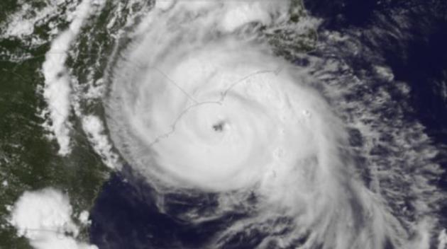
Typhoon Rammasun Comes Ashore. Although sparing Hong Kong, Rammasun was estimated by the Joint Typhoon Warning Center to be a very strong Category 3-4 hurricane as it pushed into southern China Friday.
Image credit: ga2.cira.colostate.edu
Radar Track of Rammasun. Here’s an impressive radar animation showing reflectivity and accumulated rainfall estimates from the Super Typhoon that hit southern China. Animation credit here.

July 18, 1986 Brooklyn Park Tornado Coverage. Tom Oszman at TC Media Now has done a terrific job archiving video clips from local TV broadcasts over the last 40+ years; here’s a compilation of the coverage from July 18, 1986, the day KARE-11’s helicopter tracked a tornado from beginning to end. To this day I still look at the footage and shake my head in wonder.
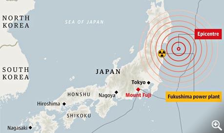
Japan Earthquake Has Raised Pressure Below Mount Fuji, Says New Study. Guardian Weekly has the story; here’s the introduction: “Mount Fuji, or Fujisan as it is known in Japanese, is the highest point on the archipelago (rising to 3,776 metres) and the national emblem, immortalised in countless etchings. In June last year Unesco added it to the World Heritage list as a “sacred place and source of artistic inspiration”. But it is still an active volcano, standing at the junction between the Pacific, Eurasian and Philippine tectonic plates. Though it has rarely stirred in recorded history, it is still potentially explosive…”
Map credit above: “Proximity of Mount Fuji to the epicentre of the March 2011 earthquake.” Christine Oliver/Guardian Source: Le Monde.
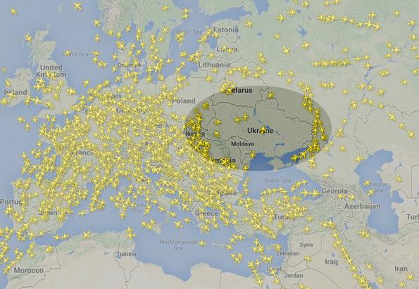
A Real-Time Picture of How Flights Are Now Avoiding Ukrainian Airspace. The Washington Post’s Wonkblog has the article; here’s a clip: “In the wake of the crash of Malaysian Flight 17, likely shot down over the Eastern part of Ukraine, several airlines have announced they will be routing flights around Ukrainian airspace. Real-time data from aviation firm FlightRadar24 seems to confirm this: it currently shows just a handful of flights over Ukraine. Many flights appear to be skirting around the eastern and western edges of the country, with just a small handful in Ukrainian airspace proper…”

Heart Rate-Sensing Car Seats Could Alert Sleepy Drivers. Gizmag has the story – here’s a clip: “Falling asleep at the wheel is extremely dangerous both for the driver, and for others sharing the road with them. A team of researchers at Nottingham Trent University are working on a solution to this driving threat. They’re doing it with sensors in a car seat that detect the driver’s heart rate, and alert the driver if they start dozing off…”

Which Colors Do You Smell? I thought this curious article at Huffington Post was worth a mention; here’s an excerpt: “…A group of international researchers, led by Carmel A. Levitan at Occidental College, tested whether our association of colors with smells is universal (hard-wired in our brains) or based on cultural factors like language and frequent association between objects and smells. Previous studies are inconclusive: Some researchers have shown that connections between odors, musical notes, and geometric shapes are hardwired into our brains. But the color-odor connection isn’t always consistent; Canadians consistently associate almond smell with the color red, but in a separate study, Australians smelled blue…”
TODAY: Some sun, isolated T-storm possible. Dry for most towns. Dew point: 62. Winds: S 15+ High: 81
SATURDAY NIGHT: Isolated thundershower, a bit more humidity. Low: 67
SUNDAY: More sun, warmer & drier. Dew point: 67. High: 86
MONDAY: Sizzling sun. Feels like 95-100F DP: 70. Wake-up: 71. High: 92
TUESDAY: T-storms with heavy rain. Risk of a few severe storms. Dew point: 72. Wake-up: 74. High: 85
WEDNESDAY: Sunnier, less humid. DP: 63. Wake-up: 69. High: 84
THURSDAY: Typical July weather. Warm sunshine. Wake-up: 67. High: 85
FRIDAY: Some sun, spotty T-storms. DP: 68. Wake-up: 68. High: 84
Climate Stories….
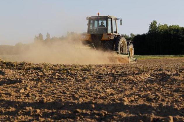
Grim Harvest: Climate Change Sweeps Iowa Farms. Many farmers, initially skeptical about climate change, are reconsidering their views, considering their experiences out in the fields in recent years. Climate volatility has gone from theory to reality. Here’s an excerpt of an Op-Ed at Live Science: “…He’s seen disease outbreaks when conditions are too wet, and lower yields when it’s too dry. Until recently, he was pretty skeptical that climate change had anything to do with it. “Before the last three or four years, I guess my vision of the world of climate change was about a few people trying to make money on the deal,” Gaesser said. He figured people were just marketing high-efficiency this and low-carbon-emission that, just to make a buck. “But as a farmer, in the last several years, we are actually seeing those changes happen here on the farm…” (File photo: Pascal Rossignol, Reuters).
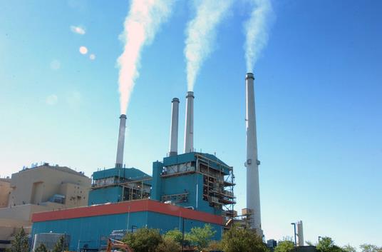
White House Announces New Climate Change Initiatives. National Geographic has the story; here’s a clip: “…The National Journal runs down the individual efforts by agency, which include a more than $236 million award to fund eight states’ efforts to improve rural electric infrastructure and a new guide by the Centers for Disease Control that will help local public health departments assess their area’s vulnerabilities to health hazards associated with climate change…” (File photo: Matt Brown, AP).
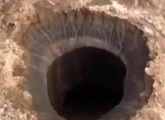
Mysterious Siberian Crater Found at “End of the World” – Is There a Larger Story Here? Daily Kos has an article speculating on the cause of a crater recently created in Siberia – is it really a possible signal of underground methane explosions as that region of Russia continues to warm? Here are a couple of excerpts: “…A mysterious crater almost the size of a football field discovered in a remote part of Siberia’s Yamal peninsula known as the end of the world may have profound implications about the stability of Arctic methane and catastrophic climate change…Permafrost in this area is melting in response to the rapid warming of the Arctic. The most likely cause of this crater is a methane explosion. See the update at at the end for a discussion that this crater was caused by the melting and collapse of an ice dome called a pingo. An Australian expert on Arctic landforms suggested pingo collapse created this crater, but Russian experts have not yet commented on his hypothesis…”

The Giant Siberian Hole: Yep, Media Does a Crap Job Reporting. It’s good to be skeptical (of everything) and Doubtful News takes a second look at the mysterious Siberian crater and counters some of the initial alarmism: “…The Arctic has experienced this melting of permafrost creating what is known as thermokarst – an alteration of the land surface due to the melting below. Russia’s permafrost areas have been measured to be warming from 0.03 to 2.8 degrees C per year. Make no mistake: This is significant and causes damage. There is no reason to think of this hole as the end of the world or the bottomless pit to hell. Smack the person who suggests this has something to do with UFOs. But, it is not doubtful news that the planet is warming catastrophically and methane explosions are realities. Closer inspection will reveal clues to whether that is what happened in this case…”
