Cold Weather Setting New Records
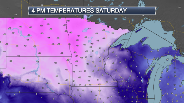
Brrr… have you ventured out into the cold the past couple days, or have you stayed inside your home as much as possible? Above were what the temperatures Saturday at 4 PM. I bring us back to Saturday as we saw a few record cold highs during the day, including:
- Twin Cities: -6 (Tied)
- Grand Forks, ND: -17
- Fargo, ND: -15
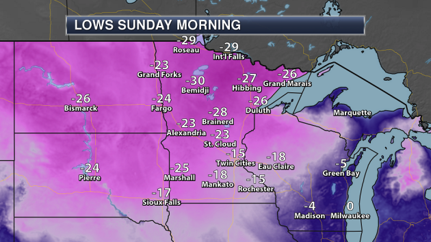
Meanwhile, here were a look at the lows across the state Sunday morning. Not listed: Embarrass, which reported a low of -45! Character building weather, just in time to end 2017.
_______________________________________________
Katabatic Winds In Grand Marais Saturday
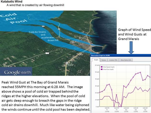
As cold air drained into Grand Marais Saturday morning, strong winds called katabatic winds were observed. More from the Duluth News Tribune: “It was a blustery day in the Northland this morning, with brisk northerly winds hitting 20-25 mph at times in many locations. But residents of Grand Marais saw far stronger gusts thanks to a weather phenomenon called katabatic winds. The National Weather Service reported that gusts at the Grand Marais harbor reached as high as 55 mph this morning. The localized strong winds were caused by cold air pooling north of town, held back by the Sawtooth Mountains.”
_______________________________________________
Happy 2018! Worst of Cold Wave Behind Us Now
By Paul Douglas
We can choose to dwell on negative numbers (I’m using the Kelvin temperature scale in protest) or we can focus on the bright side: the sun is out, it’s too ‘dang-blasted cold for heavy snow, we’ve picked up 4 minutes of daylight, the crime rate has dipped and your garbage doesn’t stink.
We ring in 2018 with high hopes, remembering some of 2017’s weather low-lights: a record 63F on February 17, 3 tornadoes on March 6, 2017 (earliest on record), a wild hailstorm on June 11, 9.45 inches of rain in Redwood Falls on August 16-17, 90s in late September and 6 subzero MSP nights in late December.
I see no evidence of a persistent blocking pattern that would keep the polar vortex swirling overhead for month after month, like 4 winters ago. NOAA’s climate models predict a milder than average January. We’ll see.
Expect more Canadian leakage this week with 4 more subzero nights this week. Models suggest 20s Sunday; maybe freezing a week from today. Mid-January may bring an extended thaw to much of America.
You survived the worst of it. No panic, no National Guard troops. Skol Viking!
_______________________________________________
Extended Twin Cities Forecast
MONDAY: Sunny, still brisk. High 2. Low -7. Chance of precipitation 0%. Wind NW 7-12 mph.
TUESDAY: Clouds increase, not as nippy. High 13. Low 2. Chance of precipitation 20%. Wind SW 8-13 mph.
WEDNESDAY: Another cold frontal passage. High 7. Low -9. Chance of precipitation 10%. Wind NW 10-15 mph.
THURSDAY: Chance of a clipper. Light PM snow? High 4. Low -6. Chance of precipitation 30%. Wind NW 5-10 mph.
FRIDAY: Partly sunny, feels like January. High 7. Low 2. Chance of precipitation 10%. Wind N 5-10 mph.
SATURDAY: Clipper may bring light snow. High 12. Low 8. Chance of precipitation 30%. Wind NE 7-12 mph.
SUNDAY: Breezy, 20s have never felt better. High 22. Low 14. Chance of precipitation 20%. Wind S 8-13 mph.
_______________________________________________
This Day in Weather History
January 1st
2003: On this date there is an inch or less of snow on the ground from Duluth to the Iowa border. In the Twin Cities there isn’t even a dirty snowbank to be found.
1997: Freezing rain causes numerous accidents along the North Shore. In Lake County, vehicles could not get up hills and were blocking roads. Highway 61 was closed for several hours from Two Harbors to Silver Bay.
1864: Extremely cold air moves into Minnesota. The Twin Cities have a high of 25 degrees below zero.
_______________________________________________
Average Temperatures & Precipitation for Minneapolis
January 1st
Average High: 24F (Record: 48F set in 1897)
Average Low: 8F (Record: -30F set in 1974)
Average Precipitation: 0.03″ (Record: 0.47″ set in 1891)
Average Snow: 0.4″ (Record: 4.0″ set in 1914)
_______________________________________________
Sunrise/Sunset Times for Minneapolis
January 1st
Sunrise: 7:51 AM
Sunset: 4:42 PM
*Length Of Day: 8 hours, 451 minutes and 7 seconds
*Daylight Gained Since Yesterday: ~0 minutes and 50 seconds
*Latest Sunrise: December 30th-January 5th (7:51 AM)
*Next Sunset at/after 5 PM: January 17th (5:00 PM)
_______________________________________________
Minnesota Weather Outlook
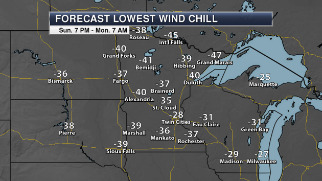
Welcome to the new year Monday morning! Unfortunately, wind chills will still be quite cold as you wake up and go outside early tomorrow morning, with Wind Chill Warnings and Advisories still in effect.
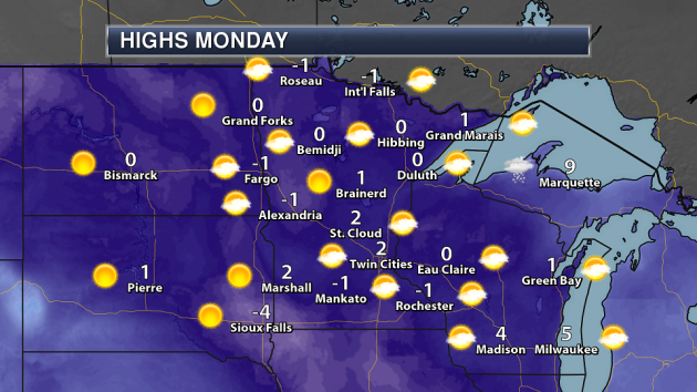
2018 brings in warmer weather for the first day of the year, with highs hovering within a few degrees of zero across the state. For some, that will still be on the negative side unfortunately.
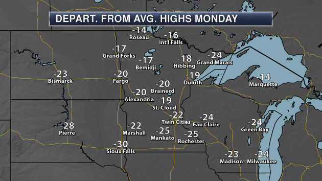
We’ll start out the year with highs that are a good 15 to 25 degrees below average. However, it’s still warmer than what we have been… so, there’s that.
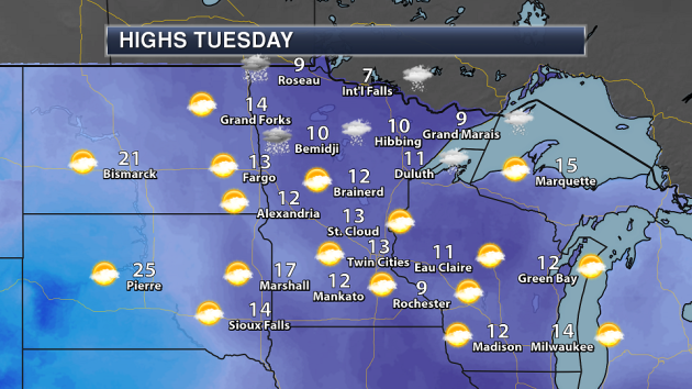
Warmer temperatures await Tuesday across the state, with many reaching the teens for highs. However, a clipper system will move through, bringing the chance of a few snow showers during the day to northern Minnesota. Some of those may reach southern Minnesota Tuesday Night.
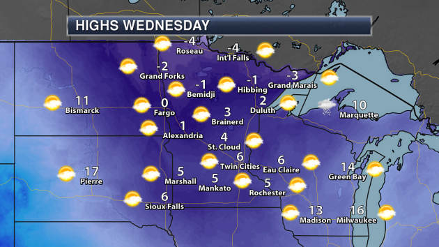
That clipper also brings in another batch of cold air to the region, with highs in the single digits above and below zero across the state Wednesday.
Below average temperatures will continue through the rest of the week in the Twin Cities, with highs in the single digits to teens. Models still show the potential of warmer weather as we head into second half of next weekend, with highs reaching the 20s.
Snow chances continue to remain minimal over the next several days. If any snow does fall Tuesday Night, it appears to not accumulate to much at the moment.
_______________________________________________
National Weather Outlook
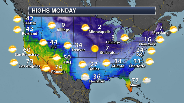
Besides the cold air continuing to sink south Monday, there isn’t too much to talk about nationwide. Lake effect snow will continue across the Great Lakes to begin 2018. Meanwhile, the cold front responsible for this arctic intrusion will continue to sink south across Florida bringing the chance of some showers. Some light sleet and rain will be possible across southern Texas.
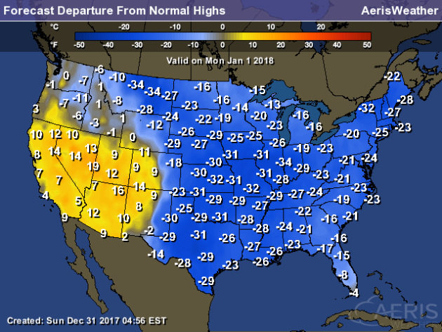
If you want to start your new year off on a warm note, head to the Southwest! That’s the only area of the lower 48 that is expected to see above average temperatures on Monday. The rest of the country will see below average highs – in some cases, up to 35 degrees below average to start 2018.

Not much precipitation is expected across most of the country through Friday morning. A system during the middle to end of the week will impact the west coast, bringing California some accumulating rain. Lake effect snow will continue downwind of the Great Lakes as well. We will be watching a potential coastal storm Wednesday into Thursday that could have some impacts on the Northeast depending how close to the coast the system actually tracks.
_______________________________________________
Erie Sets A New All-Time Pennsylvania Snow Record
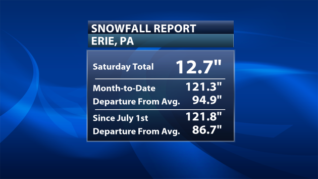
With over a foot of snow falling in Erie, PA Saturday they have now received 121.3″ of snow during the first 30 days of the month. That’s over ten FEET of snow this month, with 82.3″ of that falling from Christmas Day through Saturday.
The 121″+ of snow this December in Erie would break the previous all-time monthly snowfall in the state of Pennsylvania, according to the Pennsylvania State Climatologist. That was set in February 2010 when Laurel Summit saw 113″ of snow.
Wanted To Escape The Cold In 2017 In The Lower 48?
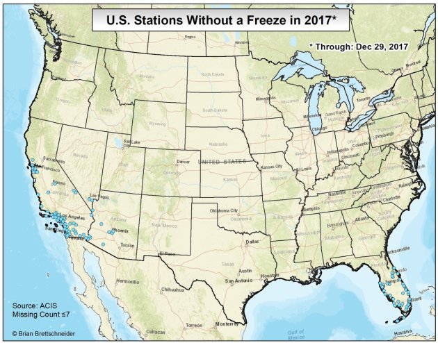
According to @climatologist49 (Alaska climatologist Brian Brettschneider), if you wanted to escape freezing temperatures in 2017 you needed to head to parts of California, Nevada, Arizona or Florida as a number of locations didn’t see a freeze. This would be the first year on record that Las Vegas did not see a freezing temperature.
In fact, for areas like Orlando and Melbourne, FL, you have to go back to 2014 for the last recorded freeze.
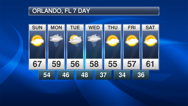
While Orlando didn’t see a temperature of 32 or below in 2017, they have the potential to see one early in 2018, according to the seven day, as overnight temperatures dive into the mid-30s for Friday morning.
Widespread Flu Across The Country
While I hope you aren’t starting off the new year with the flu, it is currently widespread across a good portion of the country according to the CDC. Glad I got my flu shot a couple months ago…
Cold Weather Doesn’t Mean Climate Change Is A Hoax
Yes, you probably saw that President Donald Trump tweet from Thursday Night. Sorry Mr. Trump, but cold weather doesn’t mean that climate change is a hoax by any means. Plus it’s winter – it’s going to be cold. More from The Verge: “Dangerously cold temperatures are hitting the Eastern US this week, prompting President Donald Trump to tweet: “In the East, it could be the COLDEST New Year’s Eve on record. Perhaps we could use a little bit of that good old Global Warming.” But scientists say that the record low temperatures and record high snowfalls aren’t proof that global warming is a hoax: they’re precisely the weather you’d expect in a warming world. There’s a lot of wrongness to unpack in Trump’s tweet, so we’ll focus on that intractable myth that climate change spells the end of cold weather. It doesn’t.”
________________________________________________
Thanks for checking in and have a great Monday! Don’t forget to follow me on Twitter (@dkayserwx) and like me on Facebook (Meteorologist D.J. Kayser)!
– D.J. Kayser
