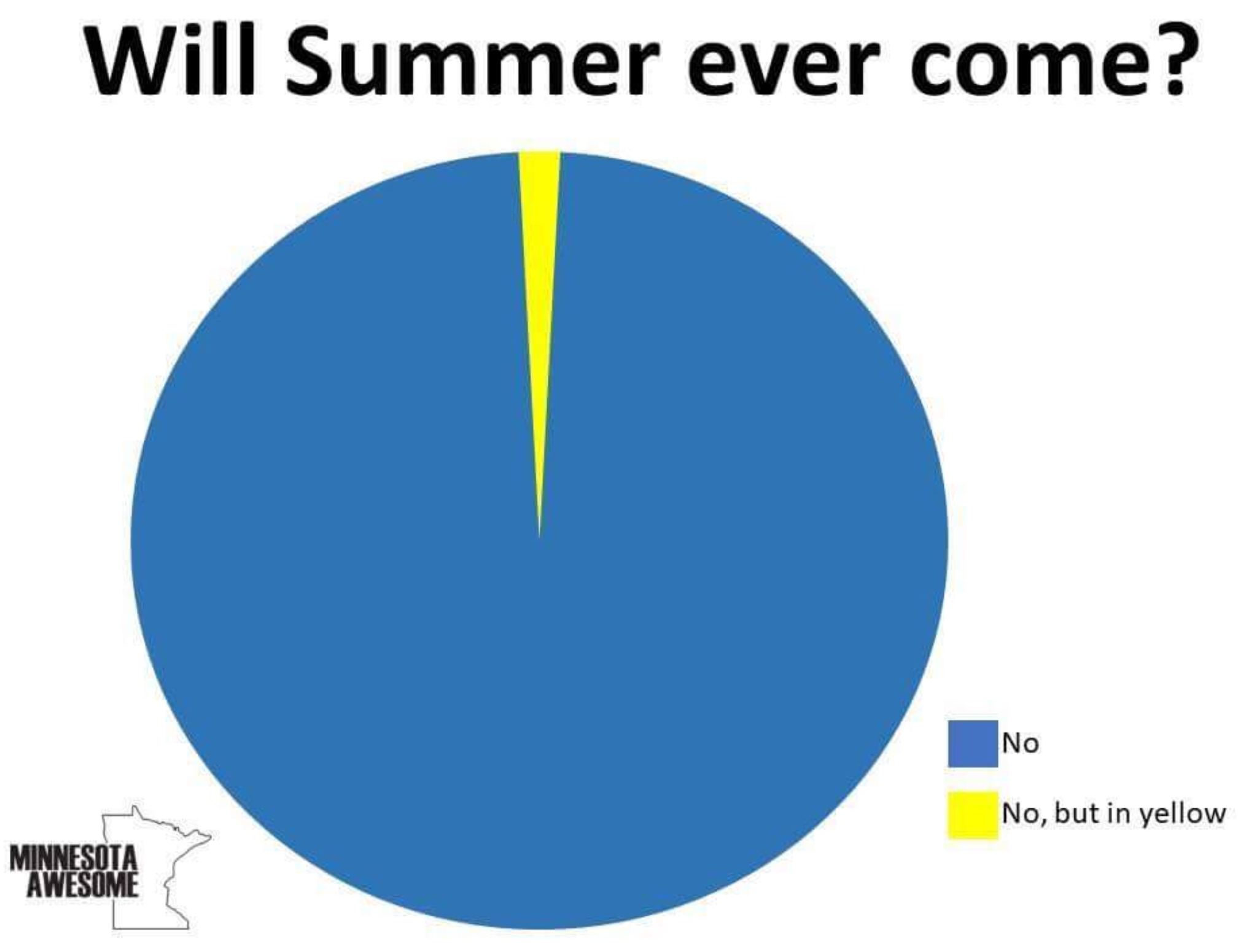
We Are All Going To Need Some Weather Therapy
Jordana Green and I have a segment on WCCO Radio every weekday afternoon at 4:20 PM called “Weather Therapy”, where I attempt to go beyond the 7-Day and delve into the whats and whys; answering
questions, comments (and threats).
The reason I bring this up: our tortured April has the entire state in need of emergency therapy. Looking at the weather maps I don’t know whether to laugh or weep.
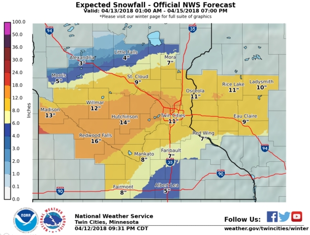
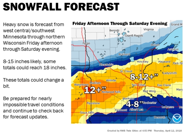
A very slow moving storm tracking south of Minnesota will tap prodigious amounts of moisture from the Gulf of Mexico – with enough cold air in place for a smorgasbord of foul weather. Rain today changes to ice tonight; with mostly snow Saturday, before slowly tapering Sunday. By then parts of the metro may have 6-12″ of slushy snow, with over a foot possible for parts of southwest and central Minnesota. Far southeastern Minnesota may pick up considerably less.
Winds will gust over 40 mph, creating blizzard conditions south/west of the metro area Saturday. Never tell a Minnesotan not to travel, but personally, I’d have a Plan B for Saturday.
40s return next week; a sun angle similar to late August melts most of the snow by midweek.
I’m sorry.
Follow the Trends. Yesterday afternoon the local NWS office was going with 7″ in the Twin Cities. They have progressively increased this over time as models appear to come into rough alignment with the axis of heaviest snow.
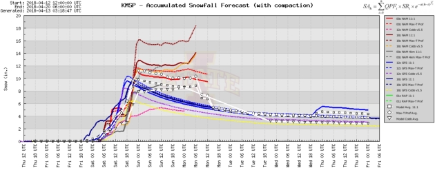
Spaghetti Plot. Earlier model runs were clustering in the 6-10″ range for the Twin Cities. 00z runs from Thursday evening were showing considerably higher amounts; well over a foot for MSP. Source: Iowa State.
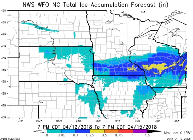
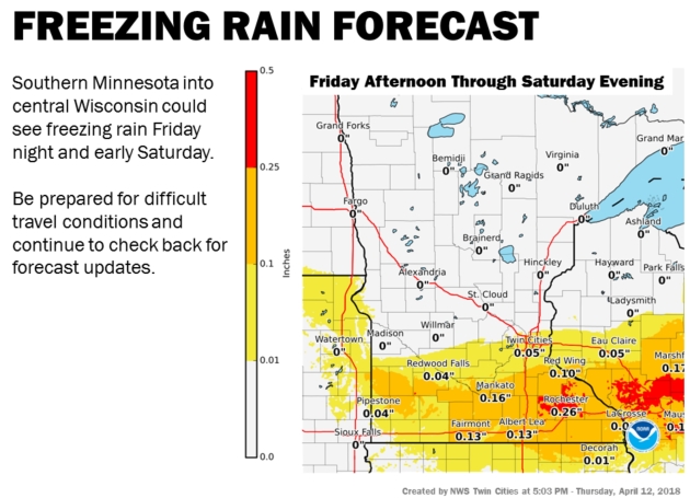
Ice Storm Potential. The best chance of sleet and glaze ice will probably set up from near Rochester into central Wisconnsin, where over .25″ of glaze is predicted – enough ice to (potentially) bring down some tree limbs and powerlines at the height of the storm.
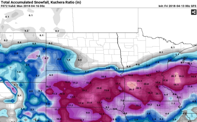
GFS Solution. Here is the 00z run (Kuchera Method) out to Sunday evening, showing the axis of heaviest snow running right over the northern suburbs of the Twin Cities. Could the storm swerve and miss us altogether? At this point I’d say no – we’ll see snow; the question is will it be 5″ or 12″ (or more?) Models have been reasonably consistent in the last 24 hours, showing a sharp drop-off in snowfall amounts just southeast of MSP. Buckle up.
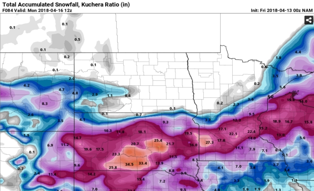
Freakishly Snowy. I’m not buying 22″ of snow at MSP, but this system is moving (very) slowly, potentially prolonging the snow from Friday night into much of Sunday. There’s also significantly more water vapor to work with than you’d have for a January storm, so some extreme amounts simply can’t be ruled out. The NAM model may be too aggressive, but even if you cut these amounts in half it could still be a very respectable pile. There’s a sharp gradient south of MSP with considerably less snow (and more ice) over far southeastern Minnesota. Source: NOAA and pivotalweather.com.
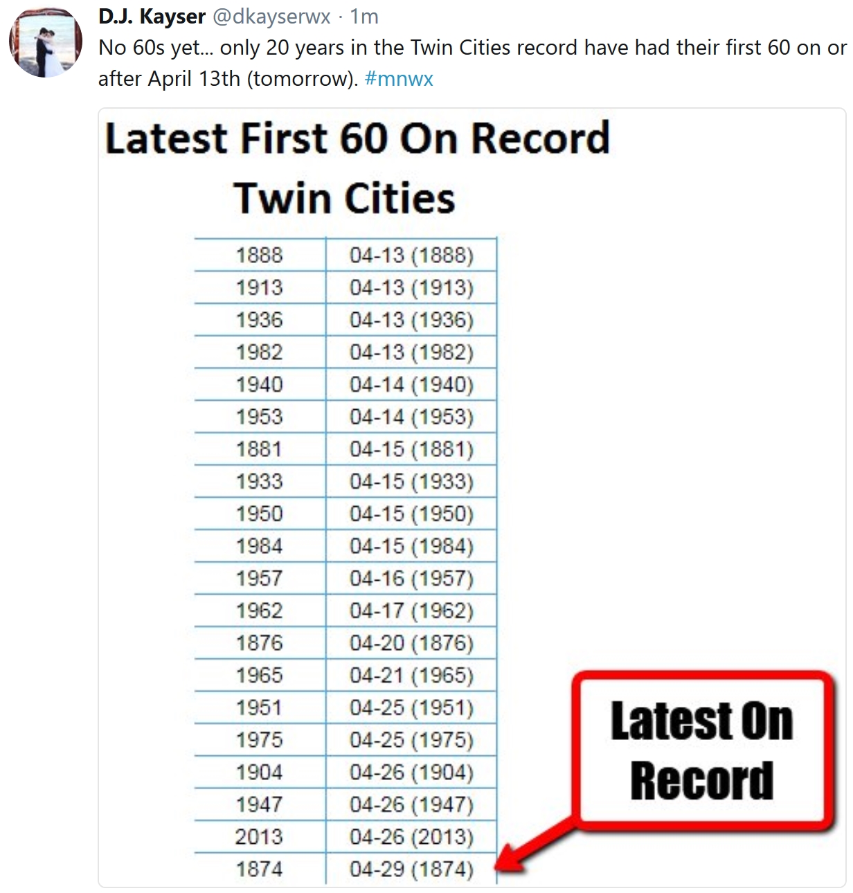
Latest First 60F in the Twin Cities. The latest on record was in 1874, on April 29th. Most recently MSP didn’t hit 60 until April 26 in 2013. Only 20 years on record have had their first 60 degree day on or after April 13th. Source: meteorologist D.J. Kayser at Praedictix.
Shades of Spring by Late April? Yeah, I’m skeptical and jaded too by this point, but a higher sun angle has to have an impact, and models suggest ridging over the central USA the last week of April with fairly consistent 50s, even a shot at 60F. I know, I’ll believe it when I see it too.
Praedictix Briefing: Issued Thursday, April 12th, 2018:
- A complex storm system will bring a plethora of weather conditions along with it that could impact facilities into the beginning of the weekend.
- An Extreme Fire Danger is in place both today and Friday across portions of the Southwest and Plains due to low humidity values and very gusty winds. Any fires that develop across this region will have the ability to quickly spread.
- A heavy snow, ice and blizzard event is expected to unfold across parts of the Northern Plains into the upper Great Lakes to end the week heading into the weekend. A band of 6-12”+ of snow is possible from the Dakotas into the Upper Peninsula of Michigan, and across parts of South Dakota and Minnesota blizzard conditions along with this snow will be possible. The freezing rain potential is greatest from southern Minnesota into northern Michigan, where 0.10-0.40” of ice is possible. Both the snow and ice will have the potential to greatly impact travel across the region.
- A severe weather exists as well Friday and into the weekend from the central United States to the east coast, with large hail, damaging winds and tornadoes possible. The greatest risk Friday is from Missouri to Texas and Louisiana, with the greatest risk Saturday from central Alabama to the central Gulf Coast. Across both these areas an Enhanced Risk of severe weather is in place for the days noted.

Extreme Fire Danger Today. As a strong system moves into the west coast and a low pressure system develops in the region, an Extreme fire danger is expected to develop across parts of the southern Rockies into the Plains. Across this area, strong winds of at least 30-40 mph are likely to develop later today, combining with low humidity values and very warm (and, in some areas, record breaking) temperatures to create an explosive environment for fires. Any fires that do develop later today will quickly spread.

Potential Wind Gusts. Any fires will certainly be fanned by gusty winds across the region today and Friday, with wind gusts of 40+ mph expected.

High Wind Concerns. An expansive area of Wind Advisories and High Wind Watches/Warnings are in effect from the Southwest into the Plains for the potential of these gusty winds today into Friday. Across High Wind Warning areas, wind gusts are expected to top at least 50 mph. Map: AerisWeather.

Fire Danger Continues Friday. We will see another day of dangerous fire conditions across this region Friday, with an Extreme fire danger in place across parts of New Mexico, Texas and Oklahoma. Very gusty winds of at least 30+ mph and low humidity values will once again contribute to produce an environment that will be ripe for fires that do form to quickly spread.

Potent System Expected. The same system that is developing late today across eastern Colorado and helping to produce the extreme fire danger will push out into the central United States into the first part of the weekend. This system will have the potential to produce heavy snow as well as severe weather as it continues to move east through the end of the week.

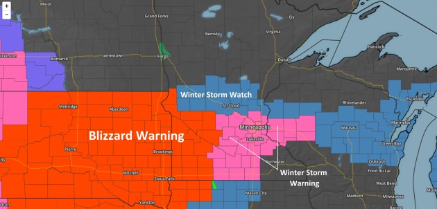
Winter Weather Concerns. Winter storm concerns extend from the northern Rockies into the upper Midwest and upper Great Lakes over the next several days as this system rolls eastward into the weekend. Areas under Winter Storm Watches and Warnings have the highest potential of receiving at least 6” of snow though the end of the week into the weekend. Blizzard Warnings have been issued across parts of western South Dakota, including the cities of Faith, Wall and Philip, where winds gusting up to 50 mph as well as 8-12” of snow (with isolated 18” amounts) will cause whiteout conditions. Blizzard conditions will also be possible as far east as western Minnesota, and there is the potential Winter Storm Watches could be upgraded to Blizzard Warnings in those areas. Some large cities under alerts this morning include:
- Billings, MT, which is under a Winter Weather Advisory from noon today to 6 PM Friday for 4-6” of snow. Rain and snow is expected today before changing to all snow tonight which will last into the morning hours Friday. Precipitation may change back over to a mix of rain and snow before ending Friday afternoon.
- Rapid City, SD, which is under a Winter Storm Warning from 3 AM Friday to 9 PM Friday for 5-8” of snow with localized amounts of up to a foot. Precipitation will start out as rain (and a few thunderstorms) this evening before changing to snow overnight, lasting into Friday evening.
- Sioux Falls, SD, which is under a Winter Storm Watch from 7 PM Friday until 7 PM Saturday for 8-12” of snow (isolated 15” amounts) and a glaze to 0.10” of ice. Precipitation will start out as rain and thunderstorm tonight and Friday, changing over to a wintry mix Friday evening before all snow is expected Friday Night through Saturday.
- North Platte, NE, which is under a Winter Storm Watch from 1 PM Friday until 7 PM Saturday for 5-8” of snow. Precipitation will start out as rain Friday, changing over to all snow Friday afternoon before tapering off early Saturday.
- Minneapolis/St. Paul, MN, which is under a Winter Storm Watch from 10 PM Friday until 1 AM Sunday for 6-10” of snow and 0.10-0.20” of ice. Precipitation will start out as rain and thunderstorms tonight into Friday before changing over to snow (possibly mixed with freezing rain) Friday evening into Saturday.
- Gaylord, MI, which is under a Winter Storm Watch from 8 AM Friday until 5 PM Sunday for 10-16” of snow and up to 0.40” of ice. A wintry mix of precipitation, with periods of rain, snow and freezing rain, is expected Friday and Friday Night. This will change over to a mix of snow and freezing rain Saturday into Sunday evening.

Snow Through Saturday Evening. A heavy band of 6”+ is expected from the Dakotas and northern Nebraska eastward across Minnesota, Wisconsin and Michigan. In some of these areas, snowfall totals will have the potential to top a foot into the weekend. This snow will impact travel across the region, with difficult to impossible travel possible. I would not be surprised to see some road closures across this region into the end of the week.

Ice Through Saturday Evening. The freezing rain and ice potential will be the highest from southern Minnesota into parts of northern Michigan, where icing totals of 0.10-0.40” will be possible. This will potentially cause power outages and tree damage across the region, with travel becoming difficult if the ice accumulates on roadways (particularly bridges and overpasses). Map: AerisWeather.

Whiteout Conditions Expected. Winds are expected to be gusty across the upper Midwest with this system. This will have the biggest impact where snow will fall, as it will create blowing and drifting snow that would lead to whiteout/blizzard conditions. We can see from Rapid City into at least western Minnesota that wind gusts are expected to top 40 mph for the end of the week into the first half of the weekend.

Severe Threat Friday. As this system marches east, it will bring a severe weather threat along with it. An Enhanced Risk of severe weather is in place Friday from Missouri south into Texas and Louisiana. Cities included in this Enhanced Risk include Shreveport, (LA), Little Rock and Fort Smith (AR), Springfield (MO) and Tyler (TX). Storms are expected to form tomorrow afternoon across this region, lasting into the evening, capable of large hail, damaging winds and a few tornadoes. Storm activity is expected to be more robust the further south in the Enhanced Risk area you go, with widespread storms across Arkansas and the ArkLaTex. In these areas, very large hail and the potential of a few strong tornadoes accompany the damaging wind risk. Due to the expected severe threat, parts of this area could be upgraded to a Moderate Risk in future updates from the Storm Prediction Center.

Severe Threat Saturday. The severe threat will continue east ahead of the cold front associated with this system Saturday, with the potential of severe storms from the Ohio Valley south to the central Gulf Coast. The greatest potential of severe storms will exist from central Alabama south, where an Enhanced Risk of severe storms is in place. Cities included in this Enhanced Risk include New Orleans and Metairie (LA) as well as Birmingham, Montgomery, and Mobile (AL). Damaging winds, large hail and a tornado or two will be possible.

Severe Threat Sunday. More severe weather is expected Sunday as this system finally pushes toward the east coast. Already a 15% probability of severe weather is in place from the Mid-Atlantic into the Southeast, with damaging winds the main concern. Cities included in this severe risk include Jacksonville and Miami (FL), Charlotte and Raleigh (NC), and Virginia Beach (VA).
D.J. Kayser, Meteorologist, Praedictix
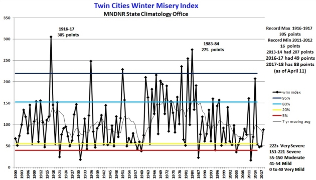
Updated Twin Cities Winter Misery Index. I have a hunch the misery will increase before we finally turn a corner into (real) spring. Here’s an excerpt of an update from the Minnesota DNR: “…As of April 11, 2018 the WMI for the 2017-18 winter is at 88 points: 43 points for cold, 45 points for snow. This is enough for 2017-18 to be categorized as a “moderate” winter. As of April 11, the winter of 17-18 has 62.5 inches of snow so far at the International Airport, 9.4 inches above normal. The WMI for the winter of 2016-17 finished with 49 points, enough for 2016-17 to be categorized as a “mild” winter. The total WMI points for the 2016-2017 winter were 23 for cold and 26 for snow: 49 points. The WMI for the winter of 2013-14 in Twin Cities was 207 points, or in the high end of the “severe winter” category. This was the 9th most severe winter on record based on WMI points. The lowest WMI score was the winter of 2011-2012 with 16 points. The most severe winter is 1916-1917 with 305 WMI points...”
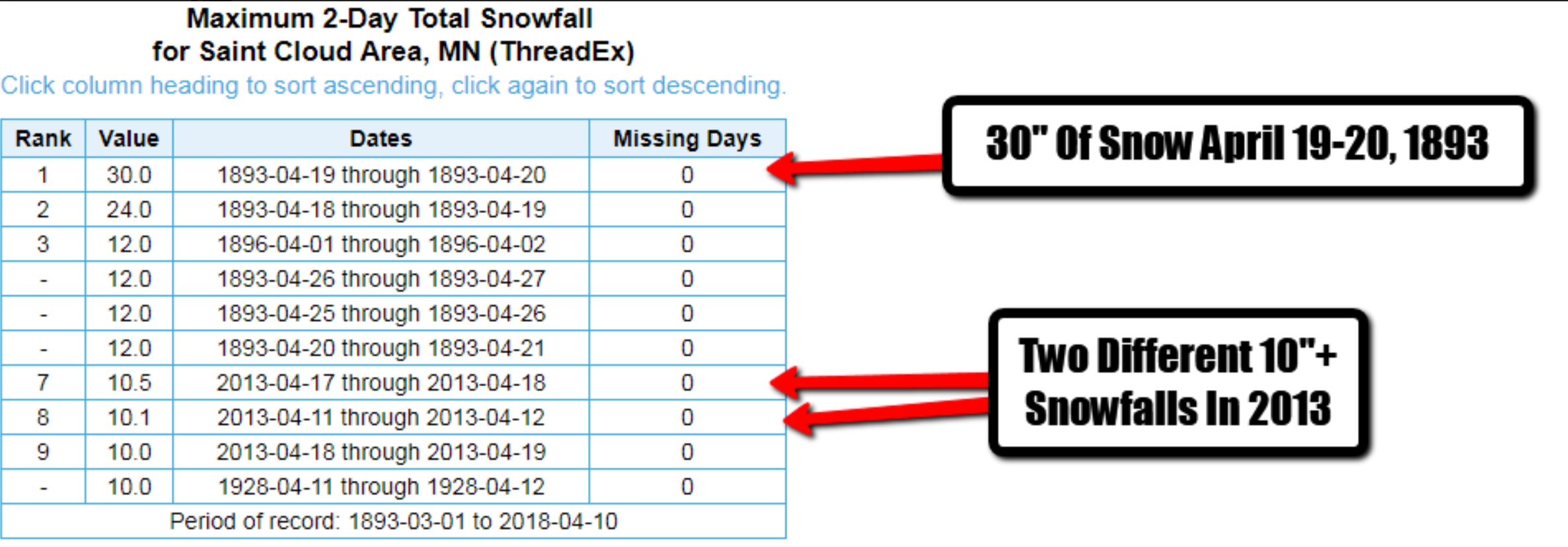
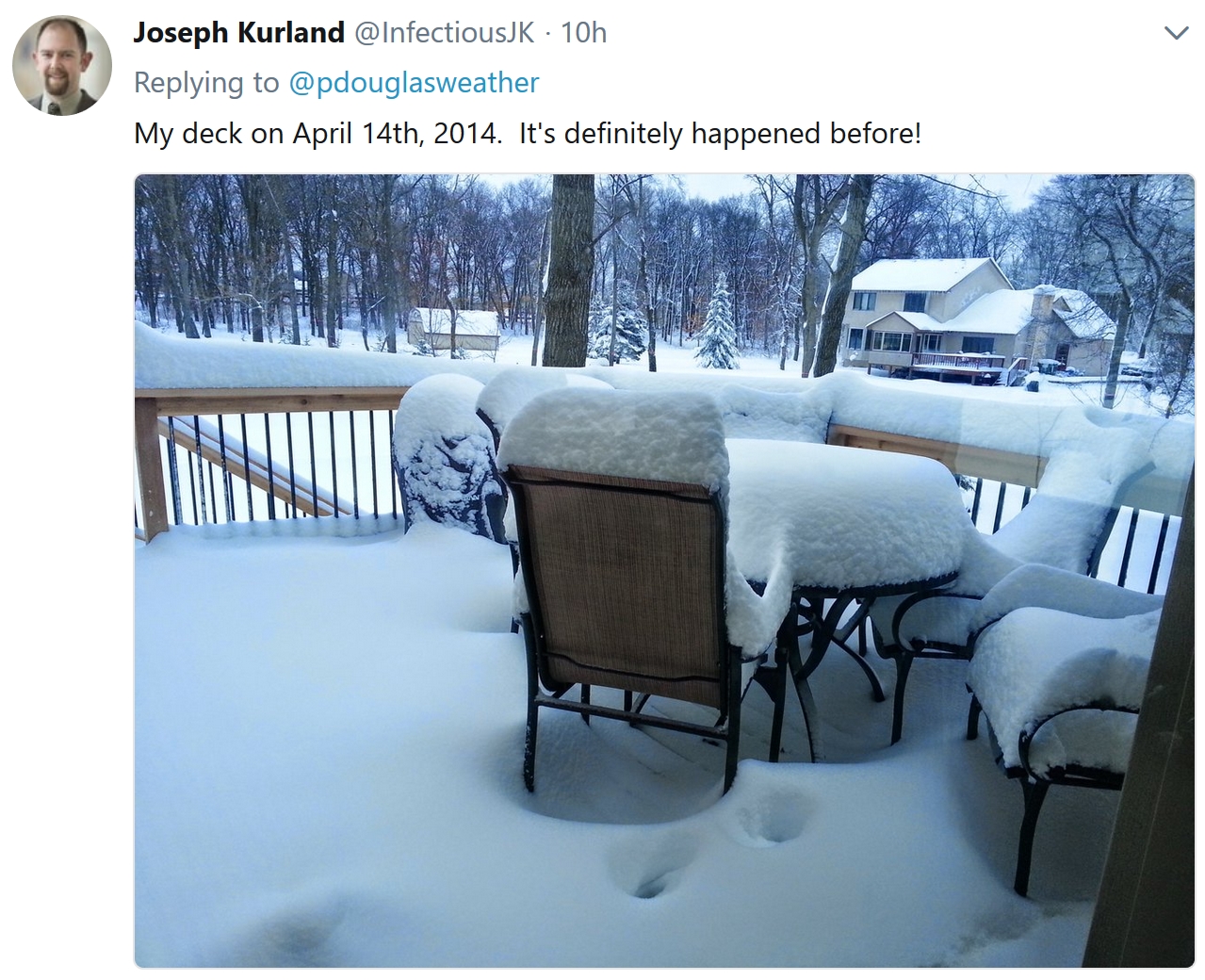
More Shriek-Worthy April Snow Statistics. St. Cloud picked up 30″ snow over a 2-day period in April of 1893. There were 2 separate 10″+ snowstorms in April of 2013, as well. Good grief.
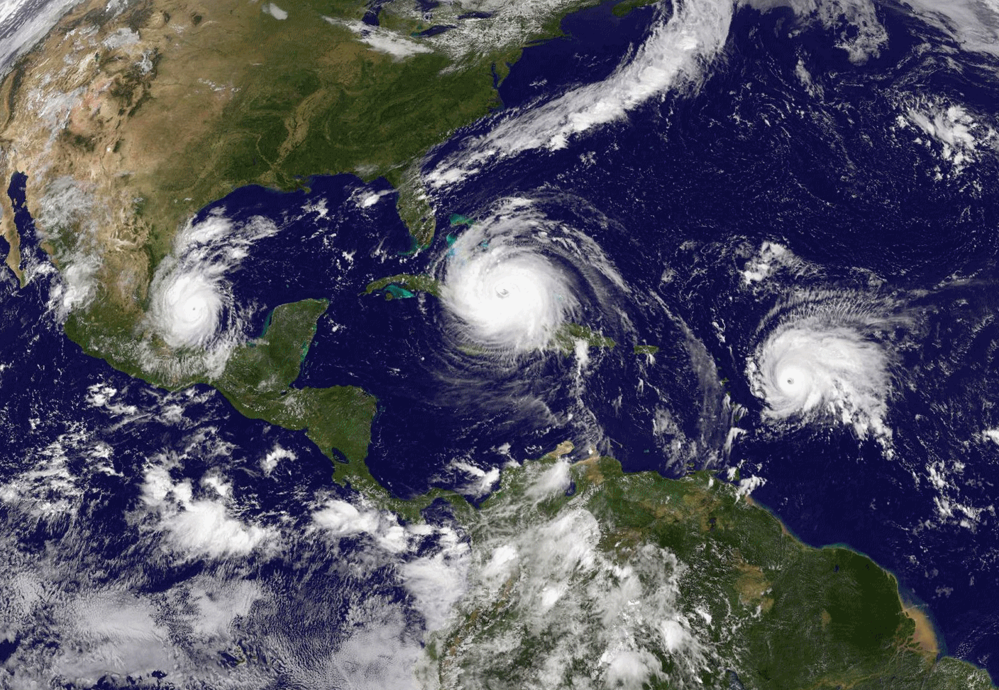
Forecasters Are Warning This Year’s Hurricane Season Will Be Worse Than Usual. A weak La Nina or ENSO-neutral pattern may (emphasis on the word may) favor lighter winds high above the tropics and more hurricanes, but confidence levels this far out are low. TIME.com explains: “…This year’s hurricane season is shaping to be another big one with a greater than 60% chance of a major hurricane hitting the U.S. coastline, according to a new forecast from top meteorologists. Researchers at Colorado State University estimate that seven hurricanes and 14 named storms will form during this year’s Atlantic hurricane season with the intensity of the season slightly above the average from recent decades. An above-average hurricane season this year would follow devastation wrecked by a series of 12 named storms in 2017. More than 100 people died as a result of major storms last year and the events caused an estimated $200 billion in damage, according to figures from the National Oceanic and Atmospheric Administration…”


The Era of Fake Video Begins. You think the proliferation of fake news via social media is bad today? Wait for it. Here’s a snippet from The Atlantic: “…Fabricated videos will create new and understandable suspicions about everything we watch. Politicians and publicists will exploit those doubts. When captured in a moment of wrongdoing, a culprit will simply declare the visual evidence a malicious concoction. The president, reportedly, has already pioneered this tactic: Even though he initially conceded the authenticity of the Access Hollywood video, he now privately casts doubt on whether the voice on the tape is his own. In other words, manipulated video will ultimately destroy faith in our strongest remaining tether to the idea of common reality. As Ian Goodfellow, a scientist at Google, told MIT Technology Review, “It’s been a little bit of a fluke, historically, that we’re able to rely on videos as evidence that something really happened...”
Image credit: Edmon de Haro.

Your Body is a Teeming Battleground. No kidding. The Atlantic reports: “...Where is the evidence that all the effort at prevention saves lives or delays death? It’s hard to find, she discovers. In people who have a strong family history of heart disease, treating high cholesterol does decrease mortality, on average. But for those who don’t have that predisposition, it doesn’t. Colonoscopies have not been proved more effective at reducing deaths from colon cancer than other, cheaper, less-invasive tests. Sometimes procedures cause more trouble than they prevent. Mammograms, for instance, detect tumors that might never be fatal, and can lead to over-treatment, which carries its own risks. The insight is counterintuitive—although finding diseases early on should prolong lives, the screenings we undergo don’t seem to lower mortality rates overall—and Ehrenreich decides that she will no longer get most preventive care…”
Illustration credit: Jules Julien.
2 of America’s Richest Zip Codes Are in Minnesota. Details via Bring Me The News: “Two Minnesota zip codes are among the richest areas to live in the country. Bloomberg Business has compiled a top 200 of the richest zip codes in the U.S., which is topped by Fisher Island, in Miami Beach. The top 10 is dominated by exclusive communities in Florida, California, New York and Illinois, with Minnesota’s two richest not even breaking the top 100… In 113th place nationally and 11th in the Midwest is the Wayzata/Minnetonka zip code 55391, which covers a broad area including western Minnetonka, Wayzata, Woodland, Deephaven, Minnetonka Beach and Orono… In 151st nationally and 16th in the Midwest is the Edina zip 55424 – which covers 50th and France and the area to the west…”

In Spite of Lousy Weather, Twin Cities Makes U.S. News Rankings of Best Places to Live. Patch.com has the highlights: “Affordability, the availability of jobs and quality of life are all things people consider when deciding where to move. U.S. News & World Report’s 2018 Best Places to Live in the United States shows people are moving to the South, Western states and the Midwest. The Minneapolis-Saint Paul metro came in at ninth place in the ranking of the country’s 125 largest metropolitan areas. Austin, Texas, was named the No. 1 best place to live for the second consecutive year. Colorado Springs, Colorado, took the No. 2 spot, bumping Denver, Colorado, to No. 3, and Des Moines, Iowa, came in at No. 4. Fayetteville, Arkansas, came in at No. 5 for the second year in a row. Rounding out the top 10 were Portland, Oregon; Huntsville, Alabama; Washington, D.C.; Minneapolis, Minnesota; and Seattle, Washington...”
File image: Midwest Energy News.

Above Average: Minnesotans Live Longer Than Most, Study Shows. Well, we got that going for us. Probably because we’re cold and well-preserved. Patch.com has the details: “A broad new study of the impacts of disease in all 50 states finds that Minnesotans live longer and healthier lives than residents of nearly any other state. However, the report finds big disparities among the states and an overall national performance that lags behind other, less developed countries that spend less on health-related costs per person. The Institute for Health Metrics and Evaluation at the University of Washington coordinated the study, which is published in the April 10 issue of the Journal of the American Medical Association. The new study ranks Minnesota fourth overall in life expectancy behind Hawaii, California and Connecticut…”

I Lived Exclusively Off Doomsday Prepper Food for a Week. Pray we never really need this stuff, but just in case, here’s an excerpt from MUNCHIES at Vice: “…Though I’d technically consumed enough calories, my stomach was still gnawing with hunger, and when I woke up the next morning, I felt energyless. I phoned Dr. Lisa Young, a New York–based nutritionist and adjunct professor at NYU, with a question: Is it really possible to live off freeze-dried food? “The answer is you probably could,” she said. Though research suggests it might cause a mild depletion of vitamin C and other antioxidant chemicals, she explained, freeze-drying fruits and vegetables doesn’t have any significant impact on their nutritional value; packaged as stand-alone ingredients, they can even make for a healthy alternative to more caloric snack foods. When I described the food I’d be eating that week, she didn’t seem too worried, but advised me to look out for added preservatives and sodium…”

New Airbus Beds Will Allow Passengers to Sleep in the Cargo Hold. Well, that sounds like a good time. Details via CNN Money: “Airbus has found a new way for passengers to stretch out — as long as they’re willing to sleep in the cargo hold. The European airplane maker has partnered with France’s Zodiac Aerospace to create cargo sleeper berths for Airbus A330 jets. They’ll be available to airlines by 2020. The mini-cabins — or passenger modules, as Airbus (EADSF) and Zodiac (ZODFF) describe them — will sit directly on the cargo floor and will not affect the loading of freight and luggage. Airlines will be able to swap the sleeping modules in and out of planes in place of regular cargo containers, the companies said...”
Image credit: “The berths are “easily interchangeable” with cargo containers.” Airbus.
52 F. maximum temperature in the Twin Cities on Thursday.
56 F. average high on April 12.
57 F. high on April 12, 2017.
April 13, 1949: A late-season snowstorm dumps over 9 inches in parts of the Twin Cities metro area.


FRIDAY: Rain, even a T-storm. Winds: NE 20-40. High: 39
FRIDAY NIGHT: Winter Storm Warning. Icy mix likely. Low: 27
SATURDAY: Winter Storm Warning. Snow, heavy at times. Rough travel. Winds: NE 20-35. High: 30
SUNDAY: Snow slowly tapers. 6-12″ possible (total) metro by late Sunday. Winds: NE 15-25. Wake-up: 23. High: 32
MONDAY: Partly sunny, much better travel. Winds: NW 7-12. Wake-up: 24. High: 43
TUESDAY: Mix of clouds of snow, almost spring. Winds: E 5-10. Wake-up: 28. High: 45
WEDNESDAY: Chance of wet snow or a mix. Winds: NW 10-15. Wake-up: 30. High: 37
THURSDAY: Intervals of sun, getting better. Winds: W 7-12. Wake-up: 28. High: 46
Climate Stories…
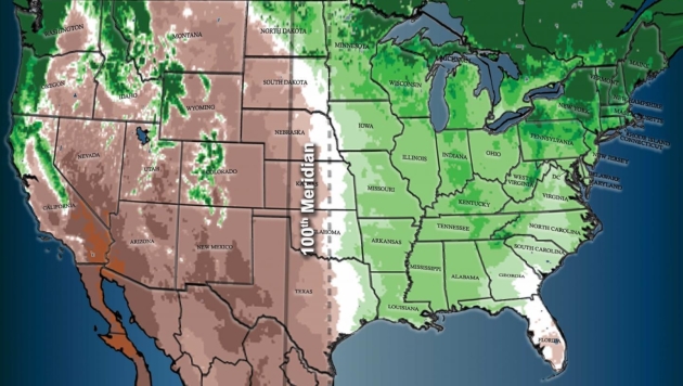
A North American Climate Boundary Has Shifted 140 Miles East Due to Global Warming. Yale E360 has the story: “…Now, 140 years later, scientists have confirmed that such a sharp climatic boundary exists and that it is slowly shifting east due to climate change — a change that scientists say could have significant implications on farming in the region. The new research, published in a pair of studies in the journal Earth Interactions late last month, found the divide is created by three factors: the Rocky Mountains stopping moisture from the Pacific Ocean reaching farther inland, Atlantic winter storms bringing moisture to the eastern half of the U.S., and moisture from the Gulf of Mexico moving north and curving eastward during the summer months. The only other clear, straight divide between humid and arid areas on the globe is the one separating the Sahara Desert from the rest of Africa, climate scientist Richard Seager of Columbia University, lead author of the new papers, said in a statement...”
Map credit: “Climate change has moved the 100th meridian west climatic divide from its historical position (solid line) 140 miles eastward (dotted line) in recent decades.” Modified from Seager et al. Earth Interactions, 2018
CLIMATE IMPACTS: Headlines and links courtesy of Climate Nexus: “Ten weather facts every layperson should know, from a layperson (Washington Post $), heat waves over the ocean have ballooned and are wreaking havoc on marine life (Washington Post $), seas are rising too fast to save much of the Mississippi River Delta, scientists say.” (Washington Post $)

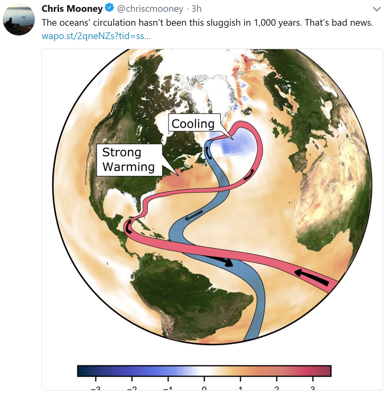
Gulf Stream At Its Weakest in 1,600 Years, Study Shows. CNN reports: “A key component of the global oceanic circulatory system, which includes the Atlantic’s Gulf Stream, is at its weakest in more than 1,600 years, a new study has found. Research recently published in science journal Nature by the University College London (UCL) and Woods Hole Oceanographic Institution (WHOI) has found that the circulation of water in the Atlantic has been declining since the 1800s. It’s a trend which could exacerbate the effects of climate change, such as rising sea levels on the US East Coast and disrupted weather patterns across North America, Europe and north Africa, including the increase in frequency of extreme weather events, like flooding, drought and winter storms...”
Increasing Snowfall in Antarctica Could Reduce Sea Level Rise, But Only a Bit. CNN has the story: “Snowfall across the great white continent of Antarctica is increasing, according to a study released this week by an international team led by the British Antarctic Survey. The team analyzed 79 ice cores from across Antarctica that provide detailed information on how much snow has fallen over hundreds of years, and it found a 10% increase in snowfall over the past two centuries. This contradicts studies that found that Antarctic snowfall has remained largely constant over the past several decades to centuries. But those studies analyzed only a few ice cores, whereas this comprehensive look at the continent gives a much more thorough view of how weather patterns have changed the polar weather…”
Studies Find Key Ocean Current Has Weakened: From Climate Nexus: “Two new studies in Nature report an important warm current in the Atlantic is closer to catastrophic collapse — which could cause rapid sea level rise on the East Coast — than it has been in the last 1,600 years. The Atlantic Meridional Overturning Circulation (AMOC) is the ocean’s conveyor belt, transporting warm water along the ocean surface to the Arctic, where it cools, sinks, and is transported southward again along the deep ocean. Human-caused global warming interferes with this process. Both of the studies looked at a signature pattern of temperatures that is tied to the strength of the current, and one also looked at the current’s speed.” (The Guardian, AP, Washington Post $)

Climate Change Will Disrupt the Way Big Agriculture is Done. Bloomberg has some interesting perspective; here’s an excerpt: “…As water becomes more scare and global temperatures rise, regulations for agriculture — the world’s largest contributor to non-carbon dioxide emissions — are likely to become stricter and farmers will demand more environmentally friendly equipment and farming techniques. Agriculture will shift from being labor-intensive to being capital intensive, with farmers relying on technology to get bigger yields from their crops, spur profits and solve problems like reduction of waste, the report said. In this scenario, one of the big winners will be precision-agriculture companies and some of their gains will come at the expense of growers, BMI said. “A larger share of farming profits will be captured by these suppliers,” and the rise of ag tech will mean higher production costs and a strong dependence on the firms providing these services, the report said. As food consumption continues to rise, commodity supplies will be strained…”
File image: iStock.
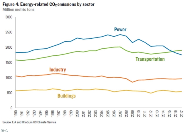
U.S. Carbon Emissions Are Declining in the Electric Sector – And Rising Everywhere Else. Vox reports: “…Power sector emissions continue to decline, but because emissions in other sectors are rising, total energy-related emissions in the US fell by only 0.66 percent in 2016-2017 — half their average annual 1.3 percent decline between 2005 and 2016. The lack of progress in other sectors is threatening to ground out progress in electricity. Thanks to coal, the US power sector was the top carbon emitter in the US economy for decades. But stagnant power demand, coupled with coal being steadily replaced by natural gas and renewables, has meant its emissions are declining. Meanwhile, vehicle miles traveled (VMT) in the US are back on the upswing after a post-2008 lull and cheap gas means Americans are once again favoring trucks and SUVs. Consequently, as of a couple years ago, the two lines crossed, and transportation has now cemented its lead as the new top emitter…”
Conservative Solutions Exist to Address Climate Change. Here’s a clip from an Op-Ed at Times Union: “…Second, Republicans have real solutions to offer that can appeal to voters across the political spectrum. Recently Bob Inglis — a former Republican congressman and executive director of RepublicEn, a nonprofit, for which I do volunteer work, that is dedicated to free-enterprise climate solutions — traveled throughout the Capital Region talking about a revenue-neutral carbon tax, which would encourage competition, increase innovation, create jobs, and shift the economic cost from hard-working Americans to exporters like China. Solutions like this from politicians with conservative credentials stand a greater chance of making progress than liberal alternatives. Third, Millennials. Climate change is a uniquely millennial issue since younger generations will bear its costs. Recent polling found 57 percent of Republicans and 77 percent of Independents believe mankind should try to stop climate change...”

CLIMATE IMPACTS: Headlines and links courtesy of Climate Nexus: “Clown fish need more energy to live in a bleached home (New York Times $), beneath the ice (Grist), extreme ocean heat waves are a thing, and they’re getting worse (Mashable), what melting sea ice means for life in the Arctic (Vox), the biology of superheroes (Nexus Media News), you’re making this island disappear (CNN), climate change will disrupt the way big agriculture is done (Bloomberg), British butterflies suffered seventh worst year on record in 2017.” (Guardian)
