.gif)
__________________________________________________________________________
____________________________________________________________________________
.jpg)
____________________________________________________________________________
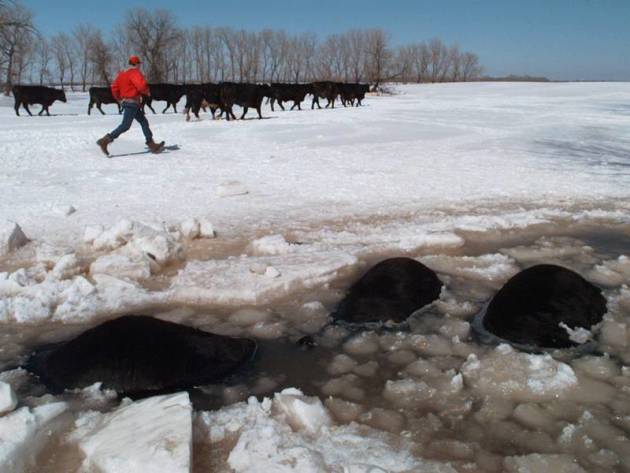
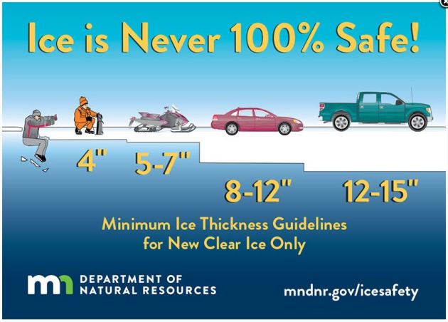
Ice Safety!!
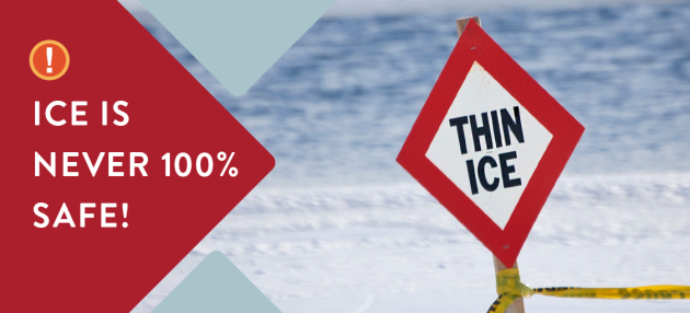
General Ice Thickness Guidelines
Under 4″ – STAY OFF
4″ – Ice fishing or other activities on foot
5″ – 7″ – Snowmobile or ATV
8″ – 12″ – Car or small pickup
12″ – 15″ – Medium truck
Many factors other than thickness can cause ice to be unsafe.
White ice or “snow ice” is only about half as strong as new clear ice. Double the above thickness guidelines when traveling on white ice.
___________________________________________________________________
.png)
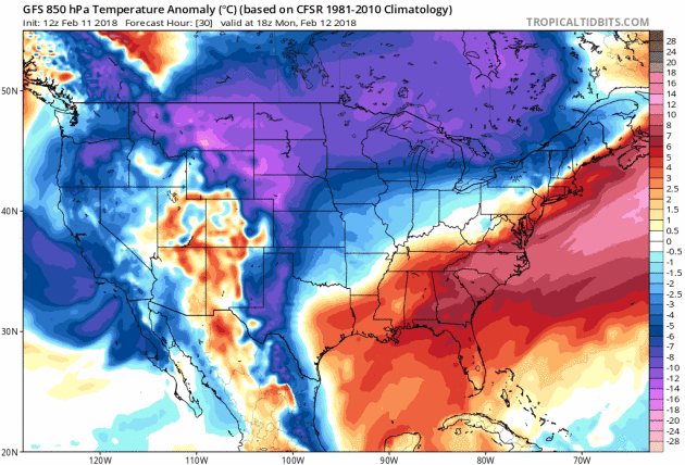
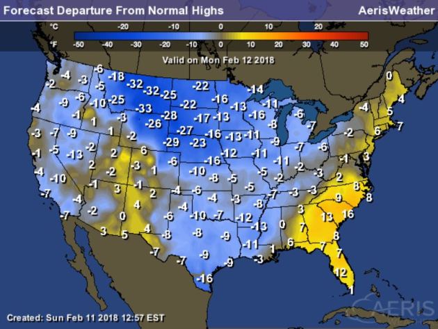
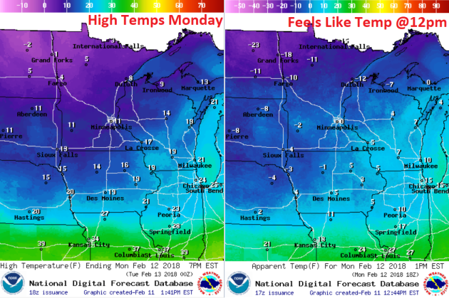
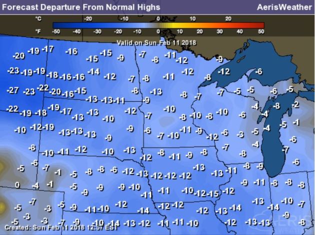
High temps across the country on Monday will be quite chilly again for much of the Nation with readings -10s to -20F below average. Some spots across Montana will be nearly -30F below average! The only spots that will be warmer than average will be in the southeast and in the Mid-Atlantic states.
.gif)
According to NOAA’s WPC, the 5-day precipitation outlook suggests areas of heavy precipitation continuing in the Eastern thrid of the nation and especially in the Southeast. Some locations there could see several inches of liquid, which could lead to areas of flooding. The other area that could see decent moisture is in the Southwest.
.gif)
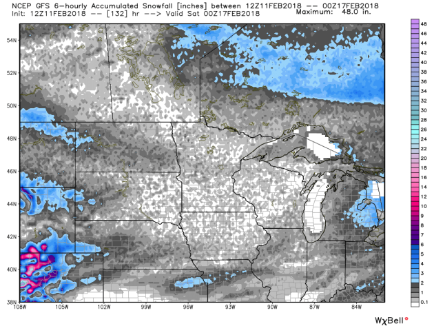
Snowfall Potential Ahead
.png)
By Paul Douglas
________________________________________________________________________
Extended Forecast
MONDAY: Plenty of sun. Winds: NW 3-8. High: 12.
MONDAY NIGHT: A little light snow? Otherwise, mostly cloudy. Winds: S 5. Low: 6.
TUESDAY: Dim sun. Closer to average temps. Winds: S 10-15. High: 27.
WEDNESDAY: Happy Valentines. Feels like March. Winds: SW 8-13. Wake-up: 20. High: 41.
THURSDAY: Mild start, then turning colder. Winds: NW 10-20. Wake-up: 20. High: 30.
FRIDAY: Partly sunny and chilly. Winds: NW 8-13. Wake-up: 2. High: 20
SATURDAY: Some sun. Risk of a thaw. Winds: S 8-13. Wake-up: 11. High: 33.
SUNDAY: Mix of clouds and sun. No drama. Winds: SW 8-13. Wake-up: 23. High: 36.
_______________________________________________________
This Day in Weather History
February 12th
1988: For warm weather…head west! Duluth had a temperature of 31 below zero, while Rapid City was sitting at 59.
1872: A severe blizzard hits central Minnesota. The temperature at Litchfield was 34 degrees on the afternoon of the 12th, and fell to -20 by the morning of the 13th. At least 6 people died in Meeker County alone.
_______________________________________________________
Average High/Low for Minneapolis
February 12th
Average High: 28F (Record: 59F set in 1990)
Average Low: 12F (Record: -30F set in 1875)
Record Rainfall: 0.42″ set in 1984
Record Snowfall: 3.2″ set in 1965
_________________________________________________________
Sunrise/Sunset Times for Minneapolis
February 12th
Sunrise: 7:18am
Sunset: 5:37pm
Hours of Daylight: ~10 hours & 19 minutes
Daylight GAINED since yesterday: ~ 2 minutes & 52 seconds
Daylight GAINED since winter solstice (December 21st): 1 Hour 33 Minutes
__________________________________________________________
Moon Phase for February 12th at Midnight
2.6 Days Before New Moon
.gif)
_________________________
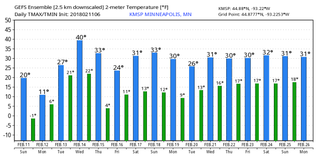
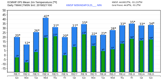
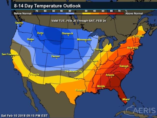
Temp Outlook For Monday
__________________________________________________________________________
Here’s the temperature outlook into the 3rd full week of February, which suggests that colder than average temperatures will continue across much of the Upper Midwest.
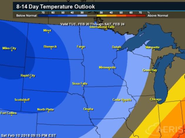
8 to 14 Day Temperature Outlook
As we head into the 3rd week of February, warmer than average temperatures will be in place across much of the Eastern US. However, colder than average temps will be in place across much of the Midwest and into the Northwest.
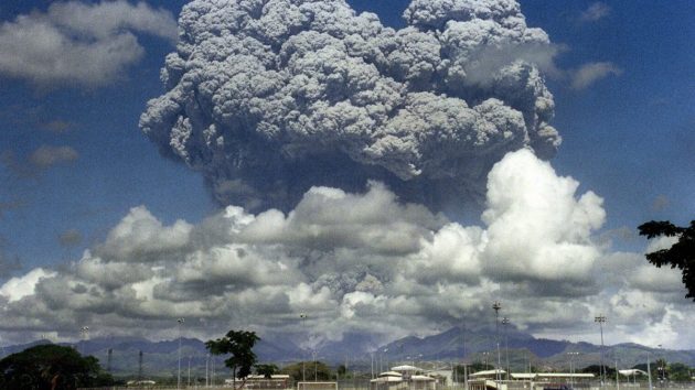
Eruptions from volcanoes in what is now Siberia have been cited as the primary cause of the event.”
See more from Independent HERE:
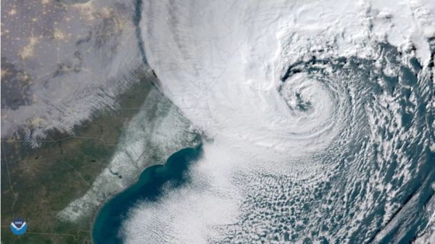
____________________________________________________________________________“How tall buildings may have ignited a thundersnow assault during the bomb cyclone”
“The so-called “bomb cyclone” in early January was a freak of nature that brought a lot of things — coastal flooding, damaging winds, and double digit snowfall. But there was one thing most people overlooked — the thundersnow. Thundersnow is a dramatic weather phenomenon which, as its name implies, is simply snow accompanied by thunder (and lightning). It only occurs when specific weather ingredients come together — usually in big and intense storms. The bomb cyclone strengthened as fast as about any East Coast winter storm on record and was a prolific thundersnow producer. But here’s the unexpected part: its thundersnow may well have been mostly artificial — not a direct product of the storm but due to manmade structures in the storm’s path. Academic research has proposed the idea that some thundersnow may be human-induced and here I present compelling evidence that it indeed was during the bomb cyclone.”
See more from Washington Post HERE:
 _____________________________________________________________________________
“We Can Now Harvest Electricity From Earth’s Heat Using Quantum Tunnelling”
“Researchers have come up with a way we could harvest energy from Earth by turning excess infrared radiation and waste heat into electricity we can use. The concept involves the strange physics of quantum tunnelling, and key to the idea is a specially designed antenna that can detect waste or infrared heat as high-frequency electromagnetic waves, transforming these quadrillionth-of-a-second wave signals into a direct charge. There’s actually a lot of energy going to waste here on Earth – most sunlight that hits the planet gets sucked up by surfaces, the oceans, and our atmosphere. This warming leads to a constant leak of infrared radiation that some estimate to be as much as millions of gigawatts every second. Because the infrared wavelengths are so short, to harness them we need super-tiny antennas. According to the international team of researchers behind the new study, it’s quantum tunnelling that could provide the breakthrough required.”
See more from Science Alert HERE:

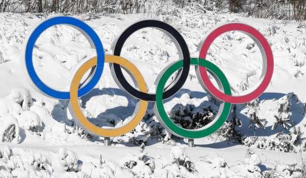
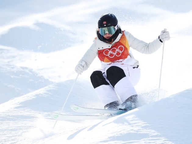
_________________________________________________________________________“WINTER OLYMPICS 2018: CAN SKI WAX HELP WIN GOLD?”
“AT THE 2014 Sochi Winter Olympics, the 4 x 10 kilometer relay was supposed to be a battle of cross-country ski titans Norway and Sweden. Felix Breitschädel watched from the sidelines as the race unfolded under a warm Russian sun. But when the first skiers emerged from the woods onto the arena packed with spectators, Norway’s first skier was nowhere to be seen. He dropped to ninth place, while the rest of the team rallied to finish fourth. For medal-hungry Norwegian ski racing fans back home, “it was a disaster,” remembers Breitschädel, equipment and technical director for the Norwegian Olympic Committee. “We were called traitors in the Norwegian media.”The culprit? Hydrocarbons gone amok. Technicians like Brietschädel had applied the wrong combination of chemical waxes to the base of the athlete’s ski. These hydrocarbon and fluorocarbon compounds—which take the form of waxes, fluids, and powders—must accomplish two contradictory tasks for skiers to win gold: grip the snow on the uphill while also gliding on the downhill.”
_____________________________________________________________________________
Thanks for checking in and don’t forget to follow me on Twitter @TNelsonWX