38 F. high yesterday in the Twin Cities.
38 F. average high on November 21.
28 F. high on November 21, 2015.
November 22, 1996: Heavy snowfall accumulates over the same areas that were hit two days earlier. Four to seven inches of snowfall are reported across the area. Heavier snowfall occurred during the daylight hours of the 23rd. Snowfall totals of six inches were reported in the Twin Cities, Chanhassen, Stewart, St. James and Redwood Falls.
November 22, 1970: Gale-driven snow falls across Minnesota. 45 mph winds are reported over Rochester and Duluth.
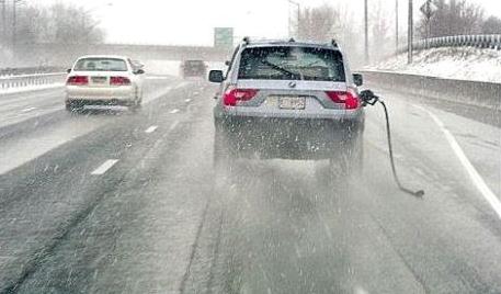
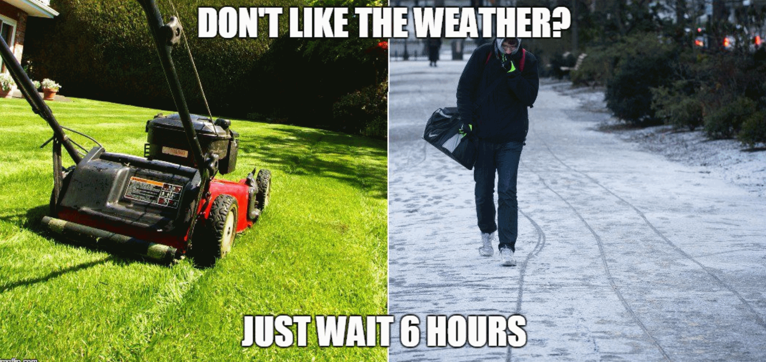
Weather Goes From Minnesota Nice to Minnesota Ice
Over the years I’ve learned a few things the hard way. The timing of a storm is obviously critical. So is the surface temperature. We tend to get hung up on snow amounts (“Hey Paul, where’s that 4 inches you promised me!”) when air temperature often determines how bad rush hour will be.
Colder storms tend to be more dangerous. Snow falling at 15F compresses into ice, and chemicals take time to melt this dangerous, slippery crust. In fact an inch at 17F can be far more hazardous to drive on than 6 inches of slush at 33F.
A layer of mild air aloft may result in a mixed bag of snow, sleet (ice pellets), even freezing rain – the most dangerous form of wintry precipitation. MnDOT-treated freeways may stay wet and slushy during the daylight hours today, but I expect roads to become icier everywhere tonight with a changeover back to snow. 2-4 inches falls by Wednesday in the metro with more over central Minnesota.
Light snow brushes southern Minnesota Thursday night; ECMWF guidance hints at a few more inches of slush Sunday night as rain changes back to snow.
Dig out the parkas – December looks good and cold.
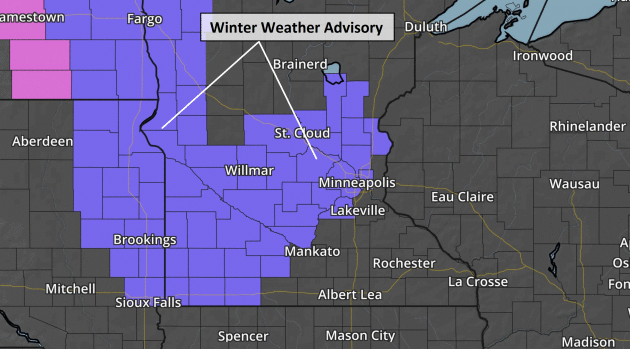
WINTER WEATHER ADVISORY REMAINS IN EFFECT FROM 2 PM TUESDAY TO 6 AM CST WEDNESDAY...

* EXPECT WET SNOW TO DEVELOP AROUND 2 PM TUESDAY AND THEN DIMINISH AROUND 6 AM WEDNESDAY.

* THE HEAVIEST SNOWFALL RATES WILL OCCUR BETWEEN 6 PM TUESDAY AND MIDNIGHT WEDNESDAY.

* TOTAL WET SNOW ACCUMULATIONS OF 2 TO 5 INCHES ARE EXPECTED.

* LOOK FOR REDUCED VISIBILITIES AT TIMES.

* PLAN ON SLIPPERY ROAD CONDITIONS.
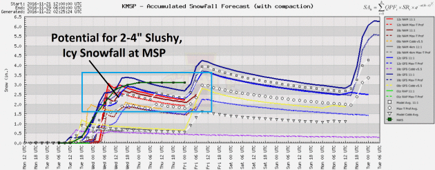
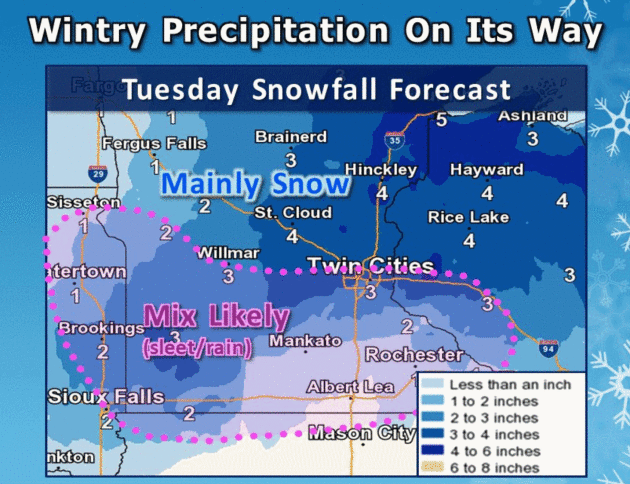
Rainy, Icy Mix Changes to Snow – Potential For 2-4″ By Wednesday Morning. Models are converging on a solution for total snowfall at KMSP, probably in the 2-4″ range (on lawns) – less on freeways and city streets. I suspect rush hour Wednesday will be more problematic than getting home later today.
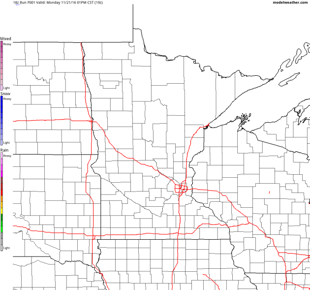
Future Radar. 4km NAM data shows a mix of rain, sleet and snow pushing across the state; mostly snow north of St. Cloud. A changeover to mostly snow occurs tonight and Wednesday morning before tapering off. A few inches of slush may pile up on lawns, while (treated) roads remain mostly-wet. Loop: AerisWeather.
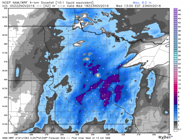
WRF Snowfall Totals. The same 4km weather model from NOAA still prints out some 6″+ amuns,especially east metro to Lake Mille Lacs. A rainy mix during the daylight hours tomorrow should help to keep totals down – still leaning more toward 2-4″ of heavy, wet, slushy snow on lawns by Wednesday morning. Source: WeatherBell.
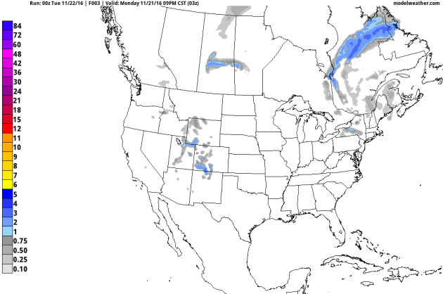
84-Hour Snowfall Potential. There is the 12km NAM model predicted snowfall product into Friday; more lake effect for upstate New York, a plowable snow from central Minnesota into Wisconsin, and snow for the highest peaks from Colorado into the Pacific Northwest. Source: AerisWeather.
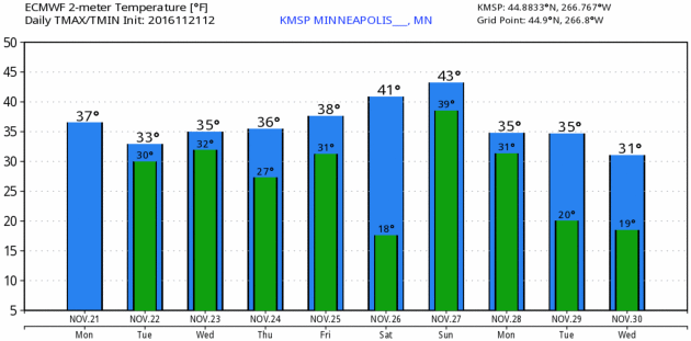
Above Average By Next Weekend. Yes, it’s been a few degrees colder than average, but ECMWF guidance warms us into the low 40s by Saturday and Sunday. And suddenly our definition of a “warm front” takes a radical turn. Source: WeatherBell.
Cold Start to December – Moderating by Mid Month. Much of the southern USA will get a taste of Canadian air by the first week of December with potential snow from north Texas into the Midwest and Ohio Valley. But there’s some evidence that milder, Pacific air may return for much of the USA by the second week of December.
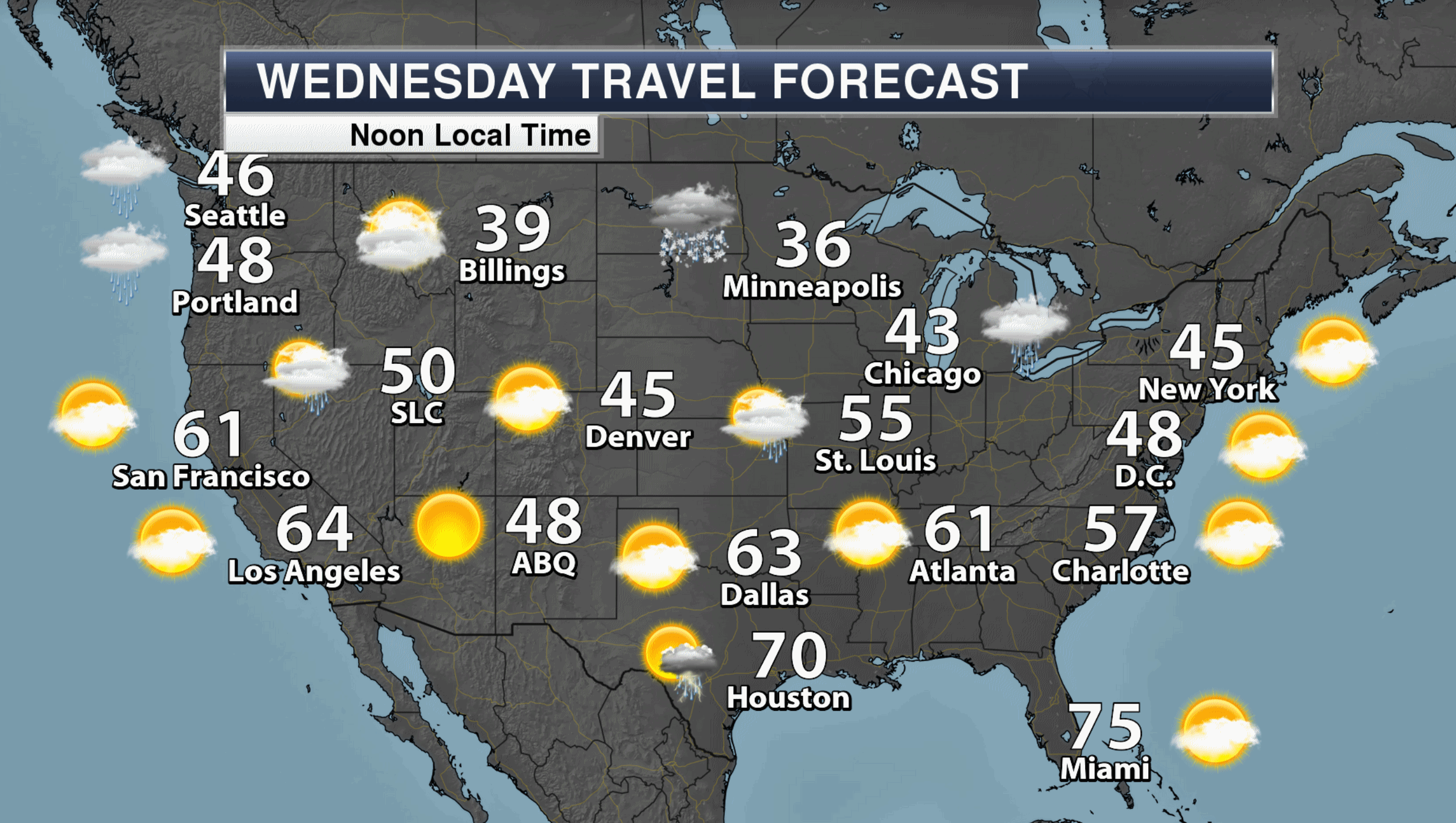
Wednesday Travel Weather. Models print out showers from the Great Lakes and Ohio Valley to the Gulf Coast. No major problems getting hom on Wednesday. Map: Aeris AMP.
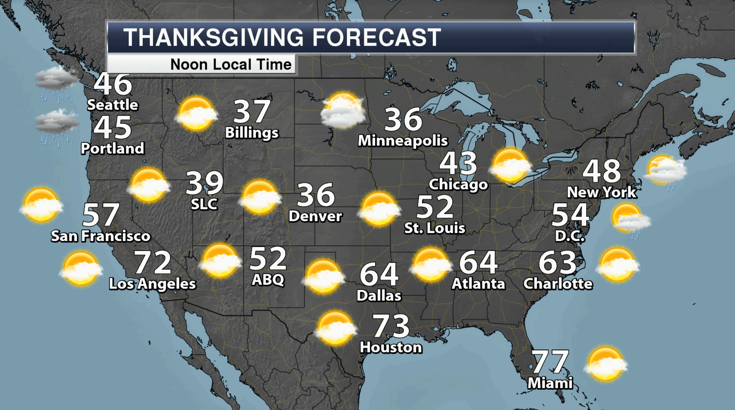
Thursday Travel Weather. Heavy rain pushes into the Pacific Northwest, otherwise relatively dry, quiet weather prevails on Thanksgiving Day with pleasant temperatures over the southern half of the USA.
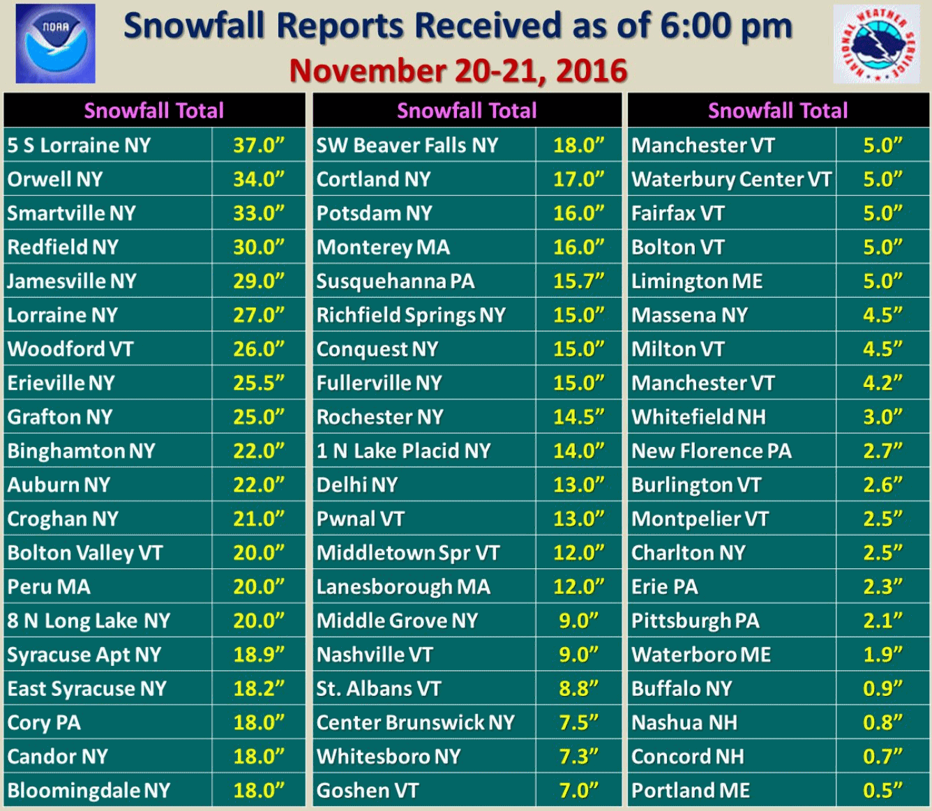
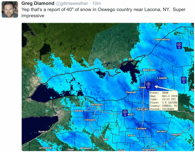
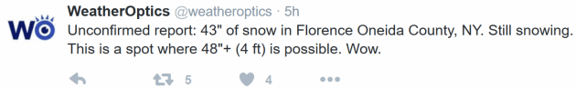
Instant Winter. Reports of serious, lake effect snows for upstate New York and much of New England:
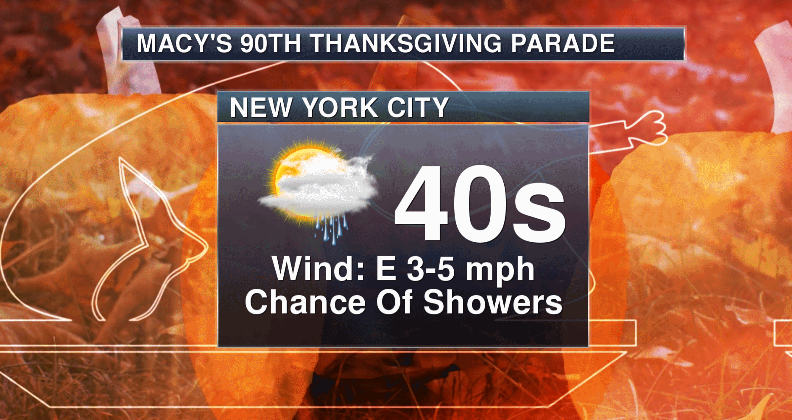
A Raw Thanksgiving Parade. Conditions are ripe for rain showers in New York City Thursday – not a steady, heavy rain, but it will definitely look and feel like late November.
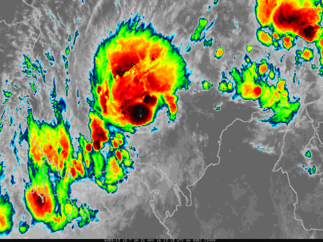
Tropical Storm Otto Forms In Southwest Caribbean. Packing 65 mph sustained winds, Otto is forecast to track westward, passing over Costa Rica and Nicaragua into the Pacific. Details via CIMSS Satellite Blog at the University of Wisconsin: “…Infrared (10.7 µm) imagery from GOES-13, above, from 1315 through 1715 UTC on 21 November, shows periodic deep convection over the Depression; the grey regions in the deepest convection over the system correspond to brightness temperatures colder than -75 C. The environment surrounding this system, shown below, is marginally favorable for strengthening; sea-surface temperatures are warm, although the oceanic heat content suggests the warmth does not extend through a deep column of water. Wind shear over the storm is modest (but far stronger north of the storm)…”
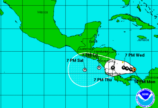
An Unlikely Track. Check out the predicted track for Tropical Storm Otto, courtesy of NOAA NHC. By the way, if Otto regains strength in the Pacific it may undergo a name change (different list of names in the eastern Pacific than the Caribbean). As if we weren’t all confused enough…
Rain Triggers 570% Surge in Los Angeles Country Freeway Crashes. Did we mention it’s only rain? I know – I know. Oil accumulating on freeways mixing with rain or even drizzle can create ice-like conditions on the highways, but good grief people. Here’s an excerpt from The Los Angeles Times: “…Over Sunday and Monday, the storm dumped more than two inches of rain in San Luis Obispo County and more than an inch at Brentwood’s Getty Center in Los Angeles County, where a surge in car crashes left freeways intermittently jammed, authorities said. According to statistics from the California Highway Patrol, between 9 p.m. Sunday and 1 a.m. Monday there were 201 reported crashes on L.A. County’s freeways — a 570% increase from the same period last week when the CHP counted 30 crashes…”
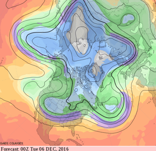
The Big Melt: Sea Ice Hits Record Lows at North and South Poles. Here’s a snippet from The Christian Science Monitor: “Sea ice levels in both the Arctic and the Antarctic have hit record lows, NASA climate scientists report. The northern record, while bleak, isn’t all that surprising – Arctic sea ice has been on a consistent decline for years. But until recently, Antarctic sea ice was actually expanding. Climate change skeptics have often pointed to ice gain in the Southern Hemisphere, which hit record highs between 2012 and 2014, but now that trend appears to be reversing. “[It] certainly puts the kibosh on everyone saying that Antarctica’s ice is just going up and up,” Walt Meier, a research scientist with the Cryospheric Sciences Laboratory at NASA’s Goddard Space Flight Center, told CNN…”
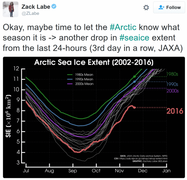
Something Really Crazy Is Happening In The Arctic. Have we reached a tipping point? I don’t pretend to know, but Tom Yulsman at Discover Magazine ImaGeo isn’t the only one who is alarmed: “Sea ice in the Arctic has been trending at record low levels since the third week of October — and now, something really crazy is happening up there. The Arctic is heading into the dead of winter, and across a vast swath of territory, the polar night has descended, with 24 hours of darkness each day. This is when temperatures should be plunging, and sea ice should be expanding rapidly. Instead, temperatures are soaring, and sea ice is actually shrinking. This shouldn’t be happening…”
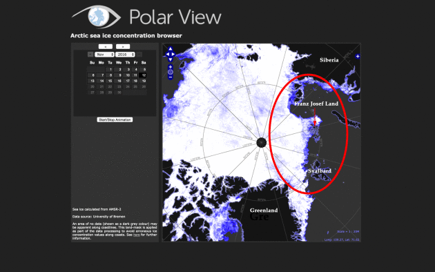
Animation credit: “Changes in the concentration of Arctic sea ice between Nov. 12 and 19, 2016 are seen in this animation of satellite data. The North Pole is at the center. Areas with 100 percent coverage of ice are depicted in white. Lighter to darker blue tones are indicative of decreasing concentrations. And areas with no ice are in gray. Ice actually decreased within the area circled in red in the first frame of the animation.” (Data: University of Bremen. Images: Polar View. Animation: Tom Yulsman).
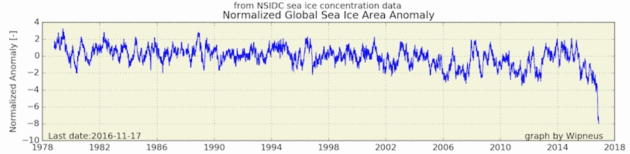
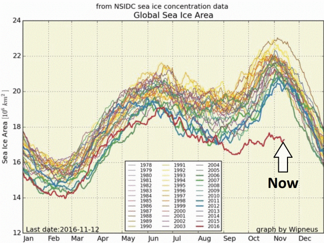
Crazy Cryosphere: Record Low Sea Ice, An Overheated Arctic, and a Snowbound Eurasia. Bob Henson has an informative post with more information about what’s happening at the top of the world at WunderBlog: “There are weather and climate records, and then there are truly exceptional events that leave all others in the dust. Such has been the case across Earth’s high latitudes during this last quarter of 2016, on track to be the planet’s warmest year on record. Sea ice extent and area have both plummeted to record lows for this time of year in both the Arctic and Antarctic. Such dramatic losses rarely occur at the same time, which means that the global total of sea ice coverage is phenomenally low for this time of year. The weirdness extends to midlatitudes: North America as well as the Arctic have been bathed in unusual mildness over the last several weeks, while Eurasia deals with a vast zone of above-average snowfall and below-average temperatures…”
Graphic credit: “The normalized value of global sea ice area as of November 17, 2016, was so far from any other total in the 37-year record that it represented a departure of about 8 standard deviations below the average! Image credit: Wipneus, using data from National Snow and Ice Data Center.” (NSIDC was not involved in producing this image.)
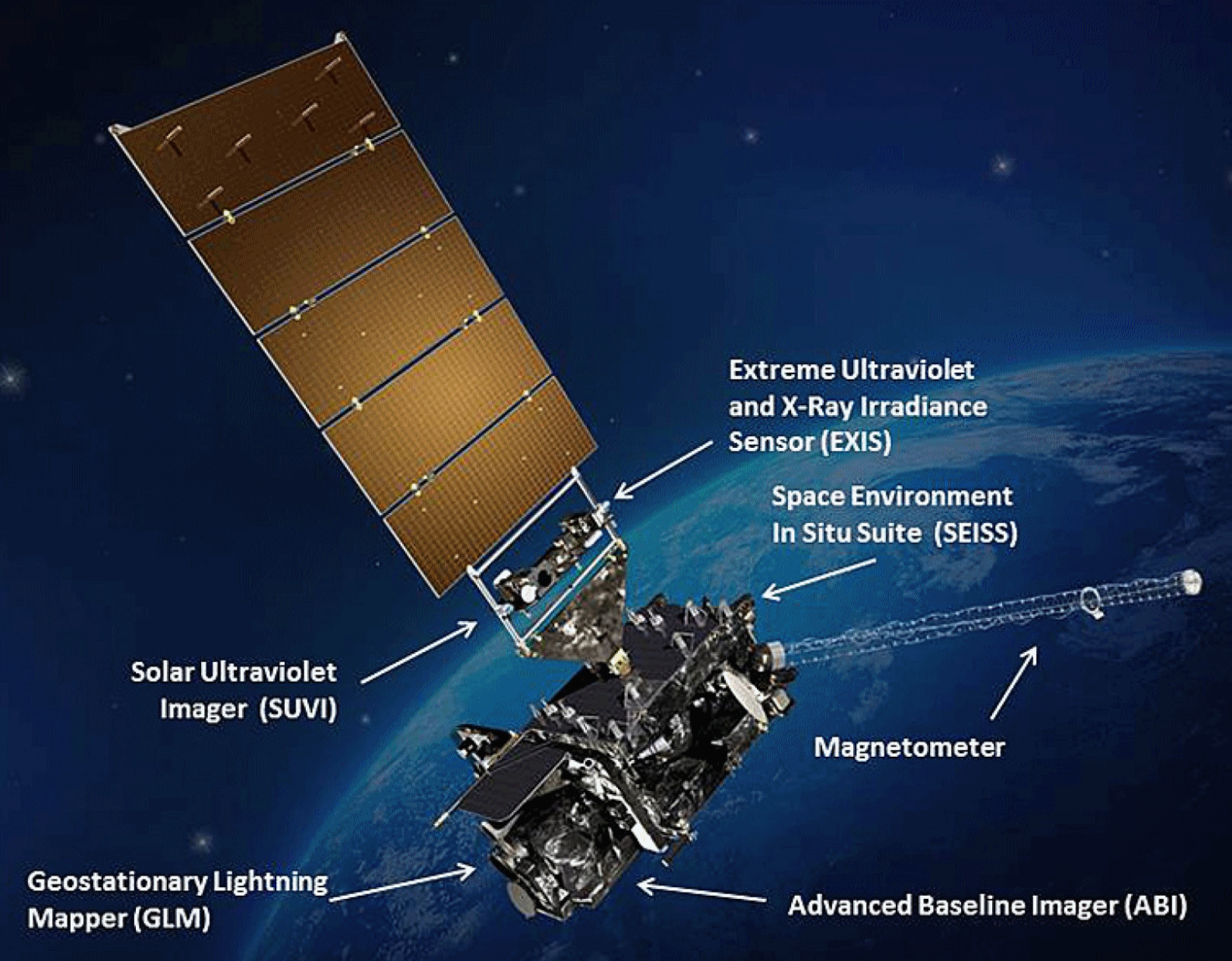
U.S. Launches Revolutionary Weather Satellite. The Washington Post has more clarity and background on what makes GOES-R a massive step forward for the science of meteorology: “…The “camera” instrument on GOES-R — called the Advanced — doubles the resolution of the current NOAA satellites. It can scan the whole hemisphere in five minutes, and if there’s a particularly dangerous weather pattern approaching, forecasters can scan a smaller region over the United States every 30 seconds. Sudden bursts of lightning could mean thunderstorms are becoming severe. So, GOES-R has a lightning mapper to continuously monitor and transmit all of the lightning strikes across North America and the surrounding oceans…”
Image credit: “Schematic of GOES-R with instruments labeled.” (NOAA/NASA).
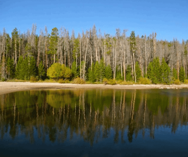
Massive Forest Death Continues in California. Summit County Citzens Voice has the story; here’s the intro: “California’s long-term drought has claimed another 36 million trees, the U.S. Forest Service said this week, announcing the results of a new aerial survey. Since 2010, more than 100 million trees have died across 7.7 million acres, the agency said. The die-off intensified in 2016, after four years of drought, with mortality increasing 100 percent. Millions of additional trees are weakened and expected to die in the coming months and years. Forest Service leaders once again emphasized that their ability to address safety issues linked with dead trees has been severely hampered by climate change and limited resources…”
Photo credit: “A stand of pine-beetle killed lodgepole pines on the White River National Forest.” @bberwyn photo.
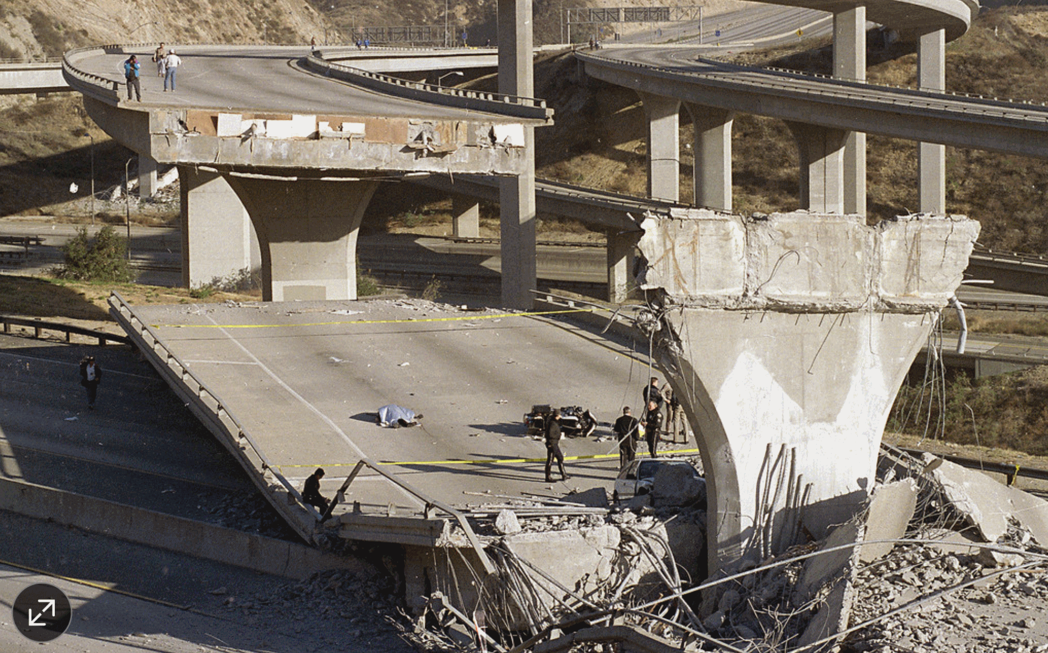
Earthquakes: Reckoning With The Big One in California – And It Just Got Bigger. Here’s a good summary of a recent study at The Wall Street Journal: “…For years, scientists believed the mighty San Andreas—the 800-mile-long fault running the length of California where the Pacific and North American plates meet—could only rupture in isolated sections. But a recent study by federal, state and academic researchers showed that much of the fault could unzip all at once, unleashing a rare, singular catastrophe. Now, insurers have used that research to come up with a new analysis of the damage that could be caused by statewide break of the San Andreas…”
Photo credit above: “A 6.7-magnitude earthquake struck the Northridge suburb of Los Angeles in 1994, causing 57 deaths and $20 billion in property damage. Researchers say a statewide quake above 8.0 could cause $289 billion in damage just to homes alone.” Photo: AP.
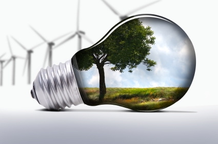
Why President Trump Can’t Squash The Innovating, Job-Creating, Money-Saving Clean Energy Industry. I have yet to meet anyone who doesn’t want to save money. If it helps to clean up the air and improves our kids’ health, all the better. Here’s an excerpt from Quartz: “…Outside of Washington, there is overwhelming support for renewable energy. Gallup found that 79% of Americans would like to see more emphasis on domestic solar energy production and they are increasingly voting with their roofs: more than one million US homes now have solar panels installed. Red states like South Dakota and Idaho are on the forefront of renewable energy adoption alongside blue states like California and Massachusetts. Clean energy is not a partisan issue—it’s a technology that can provide solid middle class jobs and energy savings for all.…”

A Golden Age For Television Series – But Can It Last? Here’s a snippet of an interesting story at The Washington Post: “…But the wild spending is stoking fears about whether or when TV’s financial bubble might burst. The glut of scripted dramas and comedies has dramatically boosted budgets, but it has not solved the industry’s most dire dilemma: The lack of a functioning business model for a new TV era. “The overall television ecosystem can’t sustain this,” said Eric Schrier, president of original programming for FX Networks, home of Emmy winners such as “The Americans” and “The People v. O.J. Simpson: American Crime Story.” “There are networks [investing] in original programming and scripted TV that are trying to justify their existence by being in that business,” Schrier added. “And as the consumer can’t consume all this content, the strong will survive and the weak will not be able to exist...”
Read more at: http://phys.org/news/2016-11-noaa-goes-r-satellite.html#jCp
Read more at: http://phys.org/news/2016-11-noaa-goes-r-satellite.html#

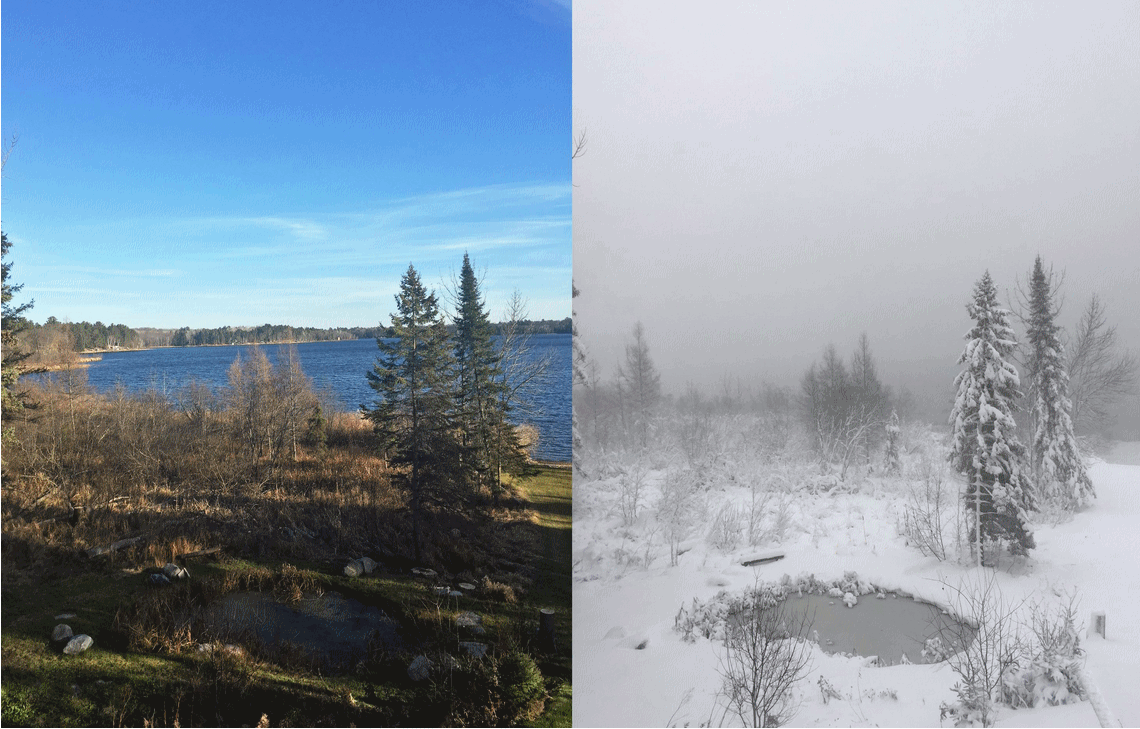
Minnesota Weather Goes From Fall to Frozen in Two Days. Reddit Freaks Out. I had to laugh, reading this post at City Pages. Check your location on a map. You live in Minnesota, where the weather (often) changes on a dime: “…During a break in the toil, Gibbs took his phone and snapped another photo, looking to capture how rapidly the weather had changed in just 48 hours. He spliced the two side-by-side. The difference in scenes is remarkable. The Wednesday “before” photo looks like a catalogue shot that could be used to sell lakefront properties. The Friday “after” shot looks like the setting for a National Geographic show about Kodiak bear hibernation…”
Photo credit: “Minnesota’s winter snuck up on us. Then whacked us in the face.” Ethan Gibbs.

WEDNESDAY: Snow tapers to flurries. 2-4″ totals in the metro. Winds: NW 7-12. High: 36
THANKSGIVING DAY: Mostly cloudy, nighttime flurries? Winds: W 5-10. Wake-up: 29. high: near 40
BLACK FRIDAY: Good shopping weather. Peeks of sun. Winds: SW 5-10. Wake-up: 28. High: 41
SATURDAY: Fading sun, nicer day of the weekend. Winds: S 8-13. Wake-up: 30. High: 44
SUNDAY: Rain changes to wet snow late. Winds: NE 10-20. Wake-up: 33. High: 45 (falling late)
MONDAY: Flurries taper, some clearing late. Winds: NW 10-20. Wake-up: 32. High: 36
Climate Stories
Paul Douglas Lays Out a Faith-Based Approach to Climate Change. My thanks to Esme Murphy and WCCO-TV for inviting me to come to the station Sunday and discuss ways to reach out to evangelicals and conservatives; to try and tell the climate story in ways that resonate with their lives and spirituality. Here’s an excerpt from CBS Minnesota: “Douglas, who was a guest on WCCO Sunday Morning, said his book in an attempt to reframe the discussion about climate change into something beyond just the science, which he describes as undeniable. “You can pile on the science, but at some point, people tune out the science,” Douglas said. “But if you frame this under the guise of clean energy, energy freedom, energy security…it’s framing the story in a way that resonates and appeals to peoples’ faith.” Douglas says that Christians, as stewards of the Earth, have a moral obligation to do something about climate change and the threat it poses to the world…”
* The complete 5 minute interview on WCCO-TV is here.
North Pole Above Freezing In Sign of “Sudden” and “Very Serious” Climate Change. Alarmist hype? We’ll see, but we are in uncharted waters. Literally. Here’s an excerpt from The Independent: “…Professor Peter Wadhams, head of the Polar Ocean Physics Group at Cambridge University, told The Independent that such warmth in the Arctic at this time of year was once virtually unheard of. “Temperatures of more than zero are really exceptional for this time of year. It’s remarkable in terms of the way the climate used to be, but over the past six years this is what’s developed,” he said. It was, he said, the result of a “sudden” change in the jet stream – high altitude winds that circle the globe and have a major effect on the weather...”
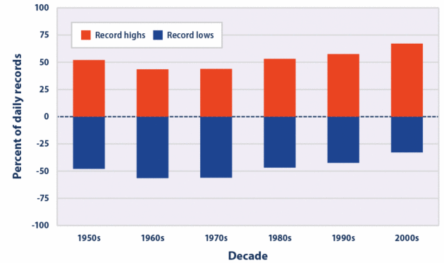
U.S. Record Heat Poised To Outpace Record Cold By Factor of 15 Late This Century. Jason Samenow reports at Capital Weather Gang; here’s an excerpt: “…Every degree of warming makes a substantial amount of difference,” Meehl said. Meehl’s latest work, with co-authors Claudia Tebaldi and Dennis Adams-Smith, builds on a study he published (with colleagues) in 2009. It found that, since 2000, about twice as many record highs as record lows had occurred in the continental U.S. If the climate was not changing, roughly an equal number of record highs and lows would have been expected…”
Graphic credit: “This figure shows the percentage of daily temperature records set at weather stations across the contiguous 48 states by decade. Record highs (red) are compared with record lows (blue).” (U.S. EPA from Meehl et al., 2009)
The Rockefeller Family Fund vs. Exxon. Here’s an excerpt of a long, fascinating and troubling story at The New York Review of Books: “Earlier this year our organization, the Rockefeller Family Fund (RFF), announced that it would divest its holdings in fossil fuel companies. We mean to do this gradually, but in a public statement we singled out ExxonMobil for immediate divestment because of its “morally reprehensible conduct.”1 For over a quarter-century the company tried to deceive policymakers and the public about the realities of climate change, protecting its profits at the cost of immense damage to life on this planet. Our criticism carries a certain historical irony. John D. Rockefeller founded Standard Oil, and ExxonMobil is Standard Oil’s largest direct descendant. In a sense we were turning against the company where most of the Rockefeller family’s wealth was created…”
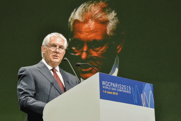
Photo credit: Pascal Sittler/REA/Redux. “Rex Tillerson, CEO of ExxonMobil, at the World Gas Conference, Paris, June 2015.”
