Fantastic Weather Ahead – Spotty Storms Sunday
By DJ Kayser, filling in for Douglas
Do you feel like you’ve been watering your plants and lawn a little more frequently?
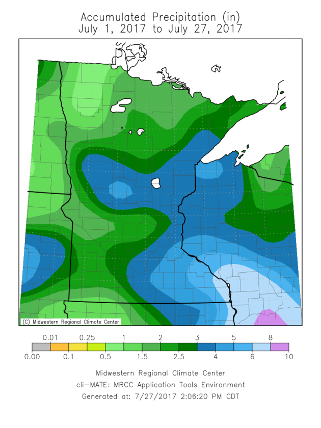
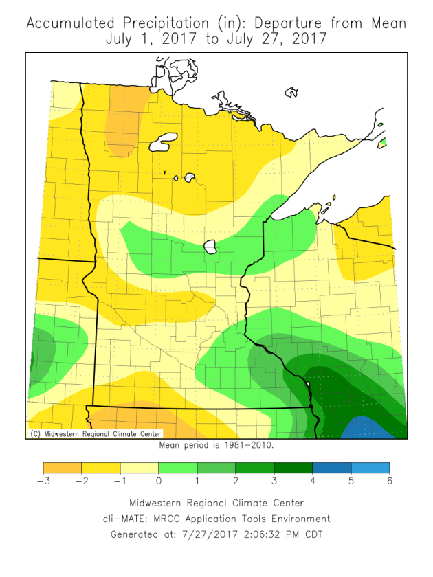
Most of the state has received below average rainfall so far this month, with the exceptions being parts of central and southeastern Minnesota, where rounds of heavy rain have set up. Even in the Twin Cities, where July is typically the third wettest month of the year, rainfall amounts are slightly below average.
Our fairly dry July will continue as we end the month and head into early August across the state. There are only a couple possible rain blips on our map: one on Sunday, and another toward the middle of next week. Otherwise, we are in for a spectacular stretch of weather, with mainly sunny skies into early August. Highs will be within a few degrees of average, with the typical summertime heat and humidity remaining off to our south.
So there are no weather concerns if you are heading out to Billy Joel later this evening. Temperatures will be in the 70s with light winds and mainly clear skies. Enjoy the nice weather!
_______________________________________________
SATURDAY: Perfect Saturday weather! High 83. Low 64. Chance of precipitation 0%. Wind S 3-8 mph.
SUNDAY: Spotty afternoon storms. Partly cloudy. High 82. Low 65. Chance of precipitation 20%. Wind SW 3-8 mph.
MONDAY: A few passing clouds. High 85. Low 66. Chance of precipitation 10%. Wind SW 3-8 mph.
TUESDAY: Sunny. Storm potential Tuesday Night. High 85. Low 66. Chance of precipitation 20%. Wind SW 5-10 mph.
WEDNESDAY: A few lingering showers. Partly sunny. High 82. Low 65. Chance of precipitation 20%. Wind NW 5-10 mph.
THURSDAY: A mix of clouds and sun. High 83. Low 63. Chance of precipitation 10%. Wind NE 5-10 mph.
_______________________________________________
This Day in Weather History
July 28th
1987: Heavy rain falls at La Crosse, WI, where 5 inches are recorded.
_______________________________________________
Average Temperatures & Precipitation for Minneapolis
July 28th
Average High: 83F (Record: 100F set in 1955)
Average Low: 64F (Record: 50F set in 1981)
Average Precipitation: 0.13″ (Record: 1.48″ set in 1942)
________________________________________________
Sunrise/Sunset Times for Minneapolis
July 28th
Sunrise: 5:54 AM
Sunset: 8:44 PM
*Length Of Day: 14 hours, 49 minutes and 39 seconds
*Daylight Lost Since Yesterday: ~2 minute and 15 seconds
*Next Sunrise At/After 6 PM: August 2nd (6:00 AM)
*Next Sunset At/Before 8:30 PM: August 8th (8:29 PM)
_______________________________________________
Minnesota Weather Outlook
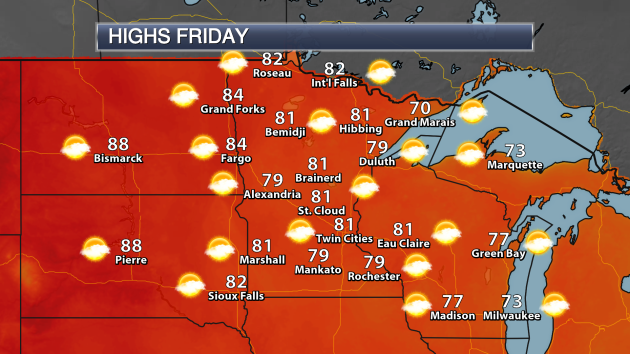
Friday will be an excellent day across the state, with highs in most areas climbing into the upper 70s to low 80s. No rain is expected across the state either, with just a mix of clouds and sun.
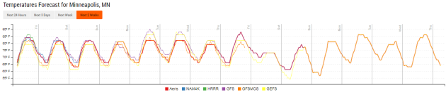
As we look at the temperature trend over the next couple weeks, highs will remain mainly around average through the end of July and into August, with not much potential for highs to reach 90 in the Twin Cities.
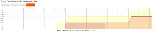
Rainfall chances continue to look light as well over the next couple weeks. There doesn’t look to be a large chance of rain in the Twin Cities Sunday – the better chance of rain will be across parts of western Minnesota. A better chance of showers and storms for the Twin Cities will be possible Tuesday Night into Wednesday. That rain is not expected to add up to much, however. After that, we look to be dry through next weekend._______________________________________________
National Weather Outlook
Friday Forecast
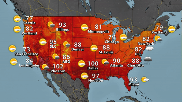
The heat continues to get squished south as we head into the end of the week, with Dallas still expected to reach 100 Friday. Storms will be possible from parts of the Northeast south into the Southeast as a cold front moves through the region. Meanwhile, monsoonal storms will continue across parts of the Desert Southwest.

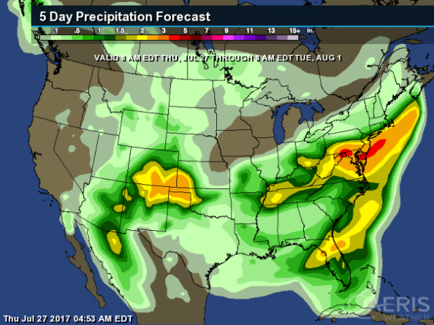

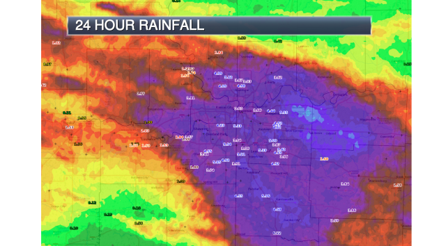
Some of the heaviest rain through Tuesday morning is expected to be in the Mid-Atlantic and Northeast, where rainfall totals could top 4″ in spots. 2″+ totals will be possible across parts of Colorado, Kansas, Texas, Oklahoma and New Mexico as well.
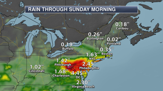
Taking a closer look at that heavy rain for the Northeast, areas from Pittsburgh to New York City, Philadelphia and Washington D.C. are expected to pick up 1-4″+ of rain through the first half of the weekend. For D.C., the heaviest rain is expected Friday into Saturday, with most of the rain falling in New York City Friday Night into Saturday. Already some Flash Flood Watches are in effect for parts of the region as we head through the next couple days.
_______________________________________________
Heavy Kansas City Rain
3-8″ of rain fell across parts of the Kansas City metro Wednesday Night, causing numerous flooding issues across the region. 2.91″ officially fell during the climate day of Wednesday (from 1 AM Wednesday to 1 AM Thursday), creating a new record for the day.

Exceptional Drought Expands in North Dakota, Montana
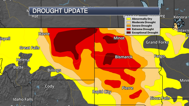
Exceptional drought continued to expand across portions of North Dakota and Montana in the latest update issued by the National Drought Mitigation Center Thursday. 7.6% of North Dakota is now under exceptional drought, up from 6.4% last week. 11.9% of Montana is now under exceptional drought as well, up from 1.5% last week. Here’s a snippet from the Drought Monitor on the conditions in the region: “Governors provided much-needed response to the dire drought impacts. Montana Gov. Steve Bullock issued an executive order declaring a drought disaster in 28 counties and five Indian reservations in the eastern part of the state. Nebraska Gov. Pete Ricketts issued an emergency proclamation, allowing the state Emergency Management Agency to address unmet drought needs, particularly those related to wildfires.”
Better Clouds… Better Forecast?

Could we get better forecasts just by representing clouds in the models better? That’s what scientists at CIRES, NOAA and the University of Wisconsin are hoping. More from the AGU Blogosphere: “Anyone with a cell phone camera and kids or dogs knows that resolution is “expensive”: taking lots of very high-resolution photographs and video clips can quickly fill a device. An analogous resolution challenge in weather and climate modeling has dogged modelers for years: Computationally, it’s just too expensive to represent certain clouds in the detail needed to make them behave realistically; yet clouds are critical to accurate weather and climate modeling. Now, a team of CIRES, NOAA and University of Wisconsin-Milwaukee experts has proposed a solution, and in a test, their new clouds even produced credible drizzle.”
Fake Blizzards For Better Planes

How do they make sure planes can fly through harsh conditions, like blizzards? Well, they test them in those conditions… in an indoor-weather testing building. More from Popular Science: “ON AUGUST DAYS IN THE FLORIDA PANHANDLE, the tropical heat steam-cooks everything. UPS drivers slap wet bandannas to their foreheads. Pirate-themed mini-golf parks, shimmering like mirages, lay deserted. But a few miles from the Gulf motels and sandy beach malls, engineers like Kirk Parrish face the worst snowstorms of their lives. Sheathed in parkas, they cold-start their pickups and drive straight into stinging, minus-40-degree whiteout blizzards. Indoors.” (Photo: U.S. Navy/Photo by Michael D. Jackson)
Amazing Weather Timelapses
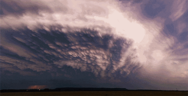
Weather timelapses always seem to be amazing (if it is more than just a timelapse of a sunny day, that is). Amazing is certainly the way to describe the latest work from Mike Olbinski. More from Gizmodo: “It might seem like photographer Mike Olbinski is always at the right place at the right time to capture Mother Nature’s fury. But for his latest film, Pursuit, he says he actually spent three months driving across 10 states to capture this amazing timelapse footage, chasing storms and weather patterns for over 28,000 miles.”
Phone Case Helps Prevent Overheating, Freezing
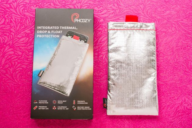
An phone case that can help keep your phone cool during the summer (and warm during the winter)? Sign me up! More on the Phoozy case (what a name…) from CNET: “A simple sleeve or “capsule” for smartphones that’s made out of spacesuit-inspired materials designed to protect astronauts, the Phoozy is the brainchild of Kevin Conway, a NASCAR driver and Lamborghini Super Trofeo World Champion who got tired of “having my phone overheat and shut down when I was outside on a hot summer day or freeze when I was snowboarding.” The Phoozy has a Chromium Thermal Barrier Shell and SpaceTech Penetration Layer, as well as a bit of velcro to keep it closed at the top. The secret to that Chromium Thermal Barrier is that it reflects 90 percent of the sun’s energy.” (Photo: Sarah Tew/CNET)
Nano-sized Satellites?
A company last month sent six satellites into space – each the size of a postage stamp. Could this be the future of satellites? More from Scientific American: “Breakthrough Starshot, the $100 million initiative aiming to send robotic missions to nearby stars by the mid-21st century, has achieved what might prove to be a “Sputnik moment” in successfully lofting its first spacecraft—the smallest ever launched and operated in orbit. In 1957 the Soviet Union shocked the world by flying the first artificial satellite, Sputnik 1, an 83-kilogram metallic orb about twice the size of a basketball that broadcast a radio message to anyone listening down on Earth. On June 23, Breakthrough Starshot sent not one but six satellites into low-Earth orbit, riding as supplementary payloads on an Indian rocket launching two other educational satellites built by the European space company OHB System AG. These six satellites are comparatively dainty, but punch far above their weight. Called “Sprites,” each is a 4-gram flake of circuit-board just 3.5 centimeters on a side, packing solar panels, computers, sensors and communications equipment into an area equal to a U.S. postage stamp. Representatives of Breakthrough Starshot, which is funded by the Russian billionaire Yuri Milner, brokered the deal that sent the Sprites piggybacking to orbit. They also worked with the U.S. State Department to ensure the project did not violate strict federal regulations limiting exports of spaceflight hardware.” (Image: A prototype Sprite nanosatellite packs power sources, microprocessors, sensors and transmitters into a single tiny circuit board. Credit: Zac Manchester)
________________________________________________
Thanks for checking in and have a great Friday! Don’t forget to follow me on Twitter (@dkayserwx) and like me on Facebook (Meteorologist D.J. Kayser)!
– D.J. Kayser

