76 F. high in the Twin Cities Thursday.
79 F. average high on August 27.
78 F. high on August 27, 2014.
August 27, 1992: A chilly night in Embarrass. The temperature dipped to 28 degrees.
Hurricane Headaches
1,260 miles of Florida coastline haven’t been hit by a hurricane in nearly 10 years. According to The Weather Channel 40 percent of all U.S. land-falling hurricanes have struck Florida; that’s 114 hurricanes between 1851 and 2010.
Sandy showed the destructive power of a Category 1 hurricane, yet in a recent survey 1 in 3 Floridians said they wouldn’t evacuate for a Category 1 storm.
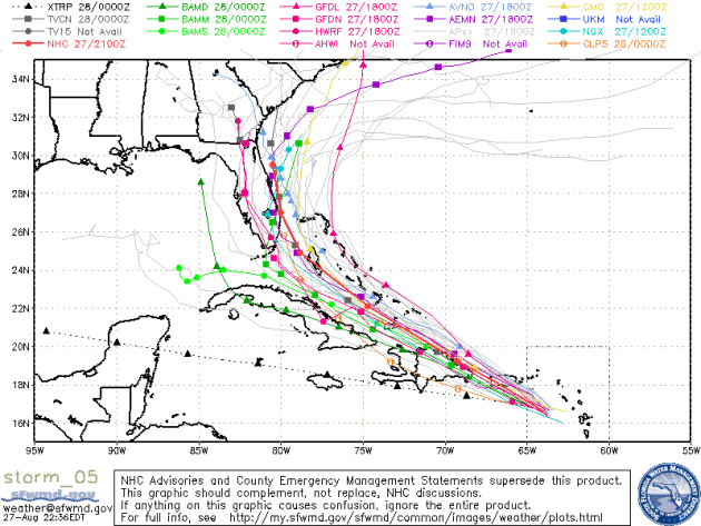
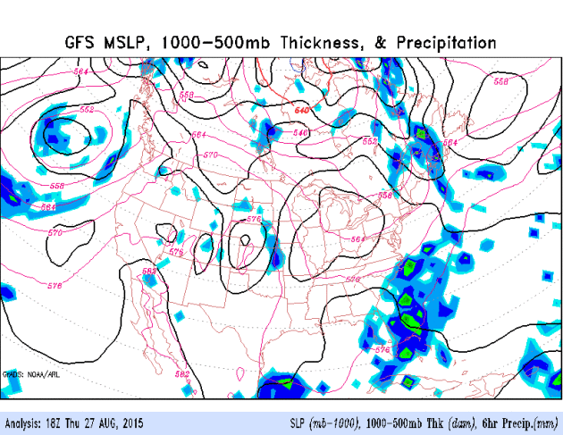
Our weather models do a fairly good job predicting hurricane track, but intensity is still difficult to forecast – a function of warm water, dry air and wind shear. The latest NOAA NHC track brings Erika near Miami as a Category 1 storm by Monday morning, but confidence levels are low. Florida’s decade-long hurricane drought may soon come to an abrupt end.
I got my fill of Sweet Martha’s Cookies at the State Fair yesterday. It would have been rude not to try a few dozen! Today looks like the coolest, wettest day in sight; heaviest rains and T-storms push across far southern Minnesota. The sun returns Saturday – daytime highs reach 85-90F from Sunday into most of next week.
The first week of September will feel like mid-July. Business as usual in the Land of 10,000 Crazy Weather Extremes.
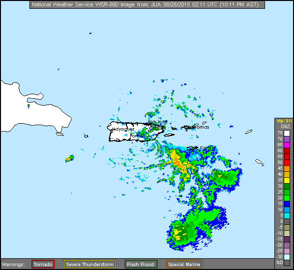
San Juan Doppler. Here is the radar loop from Thursday night showing the disorganized center of Erika wobbling westward. The greatest short-term risk is flash flooding and mudslides according to NOAA NHC:
"...The biggest short-term threat posed by Erika is very heavy rainfall
over portions of the Leeward Islands, which should spread over the
Virgin Islands and Puerto Rico tonight and early Friday.  These
rains could produce flash floods and mud slides.  More than 12
inches of rain has fallen in Dominica, with reports of fatalities
in that island..."
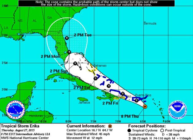
Latest Erika Path Projection. Erika will soak Puerto Rico and the Dominican Republic; skirting Haiti and Cuba while retaining tropical storm strength (no major strengthening expected next 36 hours due to wind shear), but conditions may become more favorable by Sunday and Monday as Erika approaches coastal Florida. Map credit: NOAA NHC.
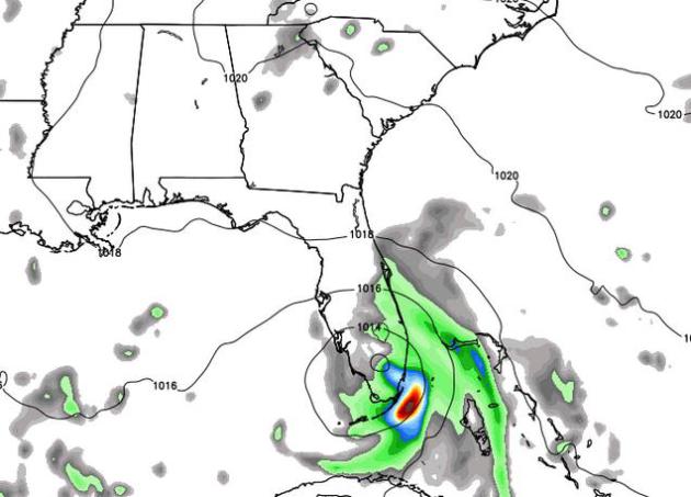
Landfall: NAM Model. NOAA’s 12 KM NAM brings Erika ashore as a strong tropical storm or weak, Category 1 hurricane near Miami by early Monday morning. Again, confidence levels for both track and intensity are low. NAM guidance: WeatherBell.
GFS Model. NOAA’s GFS suggests fairly rapid intensification off the east coast of Florida Monday and Monday as Erika pushes north-northwest, possibly fueled by warm water in the Gulf Stream. From there the GFS has the soggy remains pushing well inland, possibly sparking flooding for Charleston, Atlanta, even Memphis. We’ll see. Credit: NOAA.
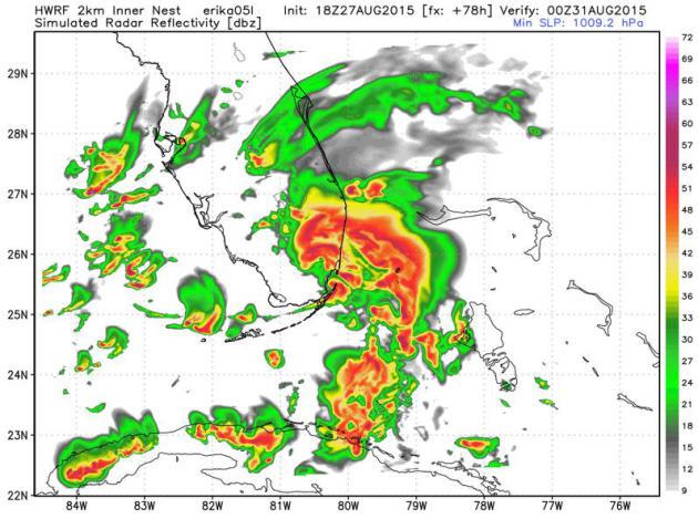
HWRF Model: Sunday Evening. NOAA’s hurricane model, the HWRF, shows a ragged, rather disorganized Erika pushing into south Florida Sunday night or early Monday morning. Future radar product valid Sunday evening courtesy of WeatherBell.
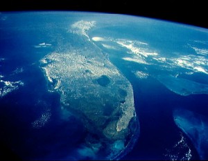
Florida Is Nearing 10 Years With No Hurricanes. Here’s an excerpt of a timely overview on Florida’s unusual hurricane drought, courtesy of The Weather Channel: “…Prior to this long period with no hurricanes in Florida, Charley, Frances, Jeanne and Ivan pounded the state in 2004. This was followed by Dennis, Katrina and Wilma in the historic 2005 hurricane season. Rita passed south of the Florida Keys that year, but did produce significant storm surge flooding in Key West. Wilma was also the last major hurricane (Category 3 or stronger on the Saffir-Simpson Hurricane Wind Scale) to make landfall in the United States. According to Dr. Phil Klotzbach of Colorado State University and blogger for wunderground.com, this year’s Hurricane Danny was the 26th straight Atlantic major hurricane to not impact the United States. The odds of that happening are about 1 in 7,400 based on the 1900-2000 rate of 29 percent of all major hurricanes impacting U.S., Klotzbach said.…” (Image credit: NASA).
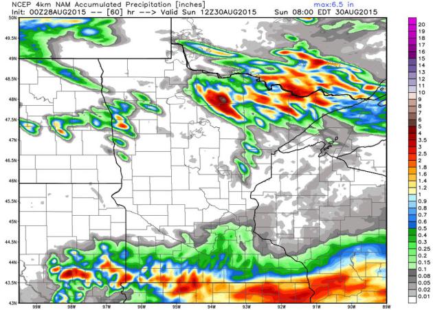
Heaviest Rains Soak Far Southern Minnesota Today. The 4 KM WRF model prints out some 1-2″ rainfall amounts near the Iowa border today; the best chance of rain over the southern metro of the Twin Cities. More heavy T-storms flare up over the Minnesota Arrowhead over the next 60 hours, while much of central Minnesota remains dry. Guidance: WeatherBell.
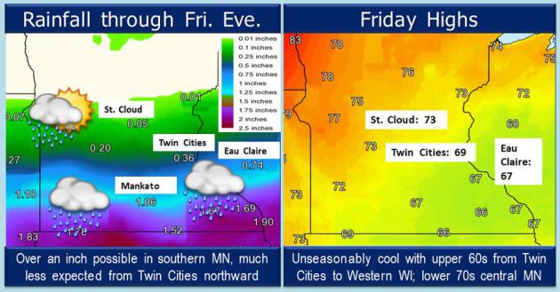
Big Variations Over 200 Miles. A fairly soggy day is shaping up for far southern Minnesota, while little or no rain is expected north and west of St. Cloud. As you drive north skies should brighten, but expect periods of rain and possible thunder from the Twin Cities to the Iowa border. Source: MPX National Weather Service.
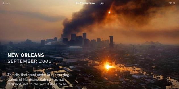
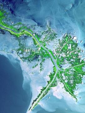
Mississippi River Mouth Must Be Abandoned to Save New Orleans from Next Hurricane Katrina. And there will be another storm – it’s as inevitable as partying on Bourbon Street. Here’s an excerpt of an article at Scientific American: “…Extensive studies done after Katrina verified what lifelong residents of southeastern Louisiana already knew: Unless the rapidly disappearing wetlands are made healthy again, restoring the natural defense, New Orleans will soon lay naked against the sea (see satellite image, below). So, how does one reengineer the entire Mississippi River delta—one of the largest in the world—on which New Orleans lies?…”
Image credit above: “An image from 2001 of the active delta front before Hurricanes Katrina and Rita destroyed much of it in 2005.” Credit: NASA

These Are The Cities Most Vulnerable To The Next Katrina. TIME has the story – here’s a clip: “…But, while New Orleans still has much work to do to prepare fully for the next storm, in some ways the storm has been a helpful reminder—albeit a painful one. For other regions that haven’t prepared, the next storm could only be a season away. According to RMS, three cities beyond New Orleans face especially high chances of large-scale damages: Miami, Tampa and New York City. Currently, Tampa faces a 1-in-80 annual chance of a storm surge event causing more than $15 billion in damage. The odds are 1-in-125 in Miami and 1-in-200 in New York City…” (Map credit: Climate Central).
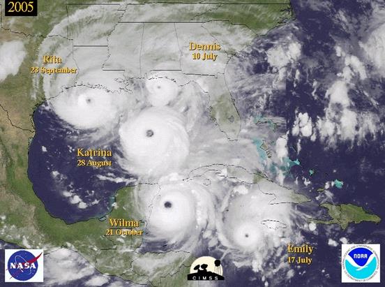
U.S. Coastline Vulnerability Is Growing To Unprecedented Levels. A decade-long hurricane drought is breeding apathy; at some point the bubble will burst and we’ll experience another year like 2005. Here’s an excerpt of a Washington Post explainer: “…The stark reality is coastal communities are living on borrowed time, and to adapt a quote from a well-known Hollywood movie, are seemingly writing checks their collective municipalities cannot cash. How rare is the current 10-year “drought”? The results of a 2015 statistical study by Timothy Hall of the NASA Goddard Institute for Space Studies indicated a nine-year hiatus in major hurricane landfall along the U.S. coastline would be expected to occur once every 177 years...”
Graphic credit above: “Montage of several 2005 hurricanes.” (CIMSS).
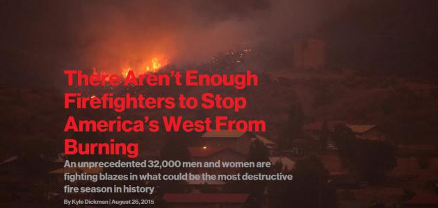
There Aren’t Enough Firefighters To Stop America’s West From Burning. Here’s a snippet from Bloomberg Business that got my full attention: “…Accounting for insurance costs, damages to businesses and infrastructure, and the flash floods and mudslides caused by denuded slopes, this year’s fires will likely cost taxpayers $25 billion—and that’s if a whole town or city doesn’t burn, which is a distinct possibility. If that happens, according to a report by the Natural Resources Defense Council, the costs could double or triple: One hundred forty million Americans live in fire-prone regions, and $237 billion in property sits in those high-risk areas. The Forest Service, the country’s largest wildland firefighting agency, has spent $800 million trying to control the flames this year, and it’s only August...”
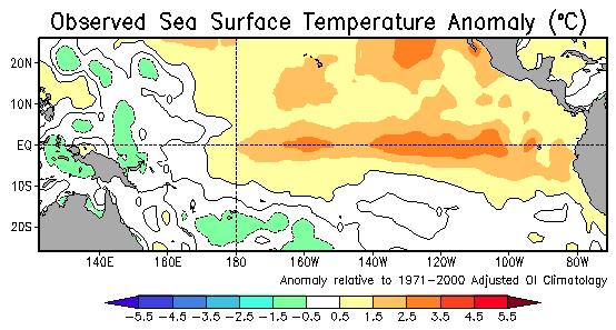
Drought-Plagued California Readies For El Nino Storms. But will they come? Here’s an excerpt from The Los Angeles Times: “…While the warming of Pacific Ocean waters tends to bring heavy winter rain to California and much of the southern and eastern U.S., California’s state climatologist noted only half the time when there have been big El Ninos has there been meaningful, heavy rains. California would need 1 ½ times its normal rainfall to get out of the extended drought, which is unlikely, according to Mike Halpert, deputy director of the National Oceanic Atmospheric Administration’s Climate Prediction Center. Emergency planners said the prolonged dry conditions across the state could lead to more debris, fallen trees and flooding during early rains…” (Image: NOAA NCEP).
These Countries Will Be Hit Hardest By Water Stress In The Future. That stress is already showing up, from Syria to the western USA; here’s a snippet from The Washington Post: “…Altogether, 33 countries, 14 of which lie in the Middle East or North Africa, are expected to face “extremely high” water risk by 2040. They include heavily populated areas where millions of people will be at risk, such as Algeria, Iran, Iraq, Pakistan, Syria, Greece and Spain. Some of the 33 nations are already fairly stressed now. Others, including Botswana, Namibia and Chile, are expected to experience dramatic increases in their water problems by 2040...”
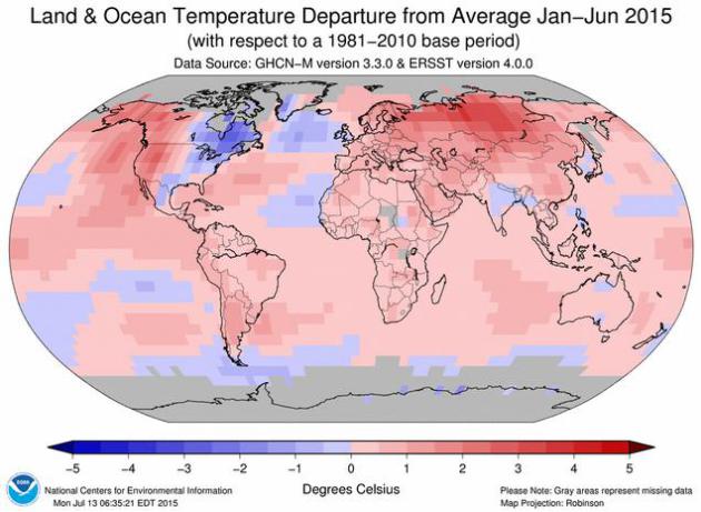
Snowy Canada Suffers Drought, Heat, Fires As Earth Gets Warmer. Here’s an excerpt from The Calgary Herald: “…Canada is possibly one of the last places that come to mind when you think about heat waves and drought. Think again. With 2015 on pace to break last year’s record for the hottest year on Earth, the snowy Great White North has discovered it’s not being spared from global warming. Western Canada, home to glaciers and source of some of the world’s longest rivers, has been enduring wildfires and dry spells from British Columbia’s Pacific Coast to the prairies in Saskatchewan. The thaw in the Rocky Mountains came too early, before enough snow accumulated to feed streams in the summer. Vancouver, known for its rainy weather, has had to restrict water use much like drought-struck California...” (Image: NOAA NCDC).
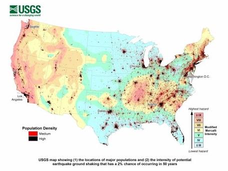
Half of U.S. Could Be Harmed by Earthquakes. Here’s the intro to a sobering report on new USGS research from sfgate.com: “Half the United States population is at risk of being harmed by earthquakes, and tens of millions are in the bull’s-eye of much stronger earthquakes. That’s the grim outlook of a U.S. Geological Survey report published earlier this month that focused on answering the great and terrible question: How devastating can earthquakes actually be to Americans and what should we do about it? The report states matter-of-factly:
More than 143 million Americans living in the 48 contiguous states are exposed to potentially damaging ground shaking from earthquakes. When the people living in the earthquake-prone areas of Alaska, Hawaii and U.S. territories are added, this number rises to nearly half of all Americans.
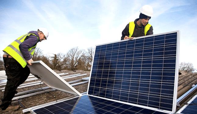
The Cheapest Oil Ever Still Won’t Slow Down The Clean Energy Revolution. It’s coming – remove all subsidies and let the markets work, and consumers decide. Here’s a clip from Mashable: “…Renewable energy use grew an average of 5% per year during the period from 2001 to 2014, with major growth seen in wind and solar in particular, the Energy Information Administration, or EIA, reported. Renewable energy accounted for nearly 10% of the energy Americans used in 2014 — the highest usage since the 1930s, when many people still burned wood for heat. Yet, just as clean alternatives to fossil fuels pick up speed, they confront a powerful old nemesis: oil, now cheaper than ever. Petroleum prices have plummeted since late summer 2014, declining by more than 60% to a record low below $40 per barrel on Monday, before recovering slightly…” (Photo credit: Solar City).

How Accurate Is The Farmer’s Almanac Winter Forecast? Take any (weather) prediction beyond 2 weeks with a monstrous grain of salt; here’s an excerpt from TIME: “…In 2007, Penn State meteorologist Paul Knight penned a damning examination of Almanac predictions. His view reflects that of much of the meteorological community—while forecasts are central to weather prediction, the chance of being accurate so far in advance is “zero,” he said. One major point of contention between meteorologists and the Almanac is the El Niño weather pattern, which the meteorological community says is getting stronger but the Almanac says is getting weaker…”


TODAY: A cool rain. T-storms south. Winds: SE 15. High: 69
FRIDAY NIGHT: Showers taper, clouds linger. Low: 58
SATURDAY: Partly sunny, much better Fair day. High: near 80
SUNDAY: Summer’s back. Warm sunshine. Wake-up: 64. High: 84
MONDAY: Hot, sticky sun. Dew point: 68. Wake-up: 67. High: 87
TUESDAY: Murky sun, isolated T-shower. Wake-up: 68. High: 86
WEDNESDAY: Hazy sun, just hot enough. Wake-up: 68. High: 88
THURSDAY: Sweltering September. Dew point: 70. Wake-up: 69. High: near 90
Climate Stories….
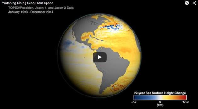
NASA Science Zeros In On Sea Level Rise. How Much? How Soon? Here’s a clip from a good summary, courtesy of NASA: “…East Antarctica’s massive ice sheet remains the primary unknown in sea level rise projections. Though it appears to be stable, a recent study found under a major glacier two deep troughs that could draw warm ocean water to the base of the glacier, causing it to melt. “The prevailing view among specialists has been that East Antarctica is stable, but we don’t really know,” said glaciologist Eric Rignot of the University of California Irvine and JPL. “Some of the signs we see in the satellite data right now are red flags that these glaciers might not be as stable as we once thought. There’s always a lot of attention on the changes we see now, but as scientists our priority needs to be on what the changes could be tomorrow...”
Animation credit above: “This video describes the causes of sea level rise and how sea level has changed over the last two decades as observed by the Jason series of satellite missions.” Credits: NASA/JPL.
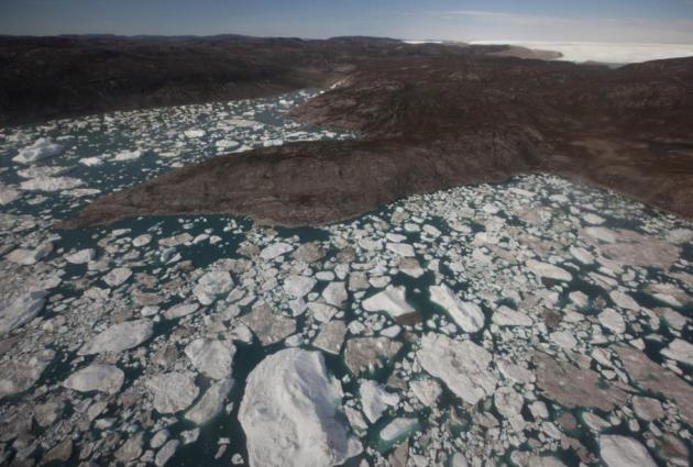
The Troubling Reasons Why NASA Is So Focused On Studying Sea Level Rise. We don’t know what we don’t know – and if anything models predicting the rate of sea level rise may be conservative. Here’s an excerpt from The Washington Post: “NASA is undertaking an “intensive research effort” into the problem of rising seas brought on by global warming, the agency announced Wednesday. And it will include satellite mounted tools so accurate that “if they were mounted on a commercial jetliner, flying at 40,000 feet, they could detect the bump caused by a dime lying flat on the ground,” as agency earth science director Mike Freilich put it Wednesday. The focus reflects the growing urgency of the topic. Recent scientific reports have documented apparently accelerating ice loss from Greenland, and potential destabilization of parts of the West Antarctic ice sheet…”
Photo credit above: “In this July 19, 2011 photo, floating ice fills a series of inlets at the edge of the Greenland ice sheet, outside Ilulissat, Greenland.” (AP Photo/Brennan Linsley)
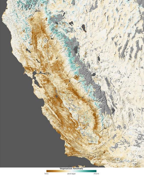
Yes, Climate Change Has a Hand In The California Drought. Here’s a clip from an Ars Techinca story that jumped out: “…In the end, the researchers calculated that anthropogenic global warming was responsible for 8 to 27 percent of the extremity of the drought between 2012 and 2014, with the dearth of rainfall chipping in around 70 percent. Because of the way they estimated anthropogenic impacts, the researchers say these numbers are conservative estimates. If you think in terms of the probability of a drought this extreme taking place, the anthropogenic contribution is enough to make it about twice as likely. The researchers write that “this analysis illustrates the general fact that the anthropogenic drying trend, while still small relative to the range of natural climate variability, has caused previously improbable drought extremes to become substantially more likely...”
Image credit above: “Vegetation was pretty sparse in early 2014.” NASA Earth Observatory
