60 F. high in the Twin Cities Thursday.
65 F. average high on October 2.
77 F. high on October 2, 2013.
.75″ rain fell yesterday at MSP International Airport.
1.45″ rain fell October 1-2 in the Twin Cities.
October 2, 1999: Earliest ever single digit temperature in Minnesota for Fall. Embarrass had a low of 9 degrees.
October 2, 1922: Hot fall day. 95 in Ada and 93 at Moorhead.
Say It Ain’t Snow
This is a test. This is only a test. Mother Nature will test your sense of humor this weekend. Are you stoic – do you take things in stride, or do you agonize over things you can’t change?
Only in Minnesota, Land of 10,000 Weather Extremes, is it possible to go from 82F and sunburn on a Sunday to slushy snow, heavy jackets and scattered scowls five days later. Each successive computer run is colder and wetter for tonight & early Saturday Saturday; the freezing level forecast to be low enough for wet snow to mix in with the rain, even as far south as the Twin Cities.
Before you unleash a primal scream consider that ground temperatures are still in the 50s. Any snow that mixes in late tonight will probably melt on contact. That said, a coating of slush is possible near St. Cloud; maybe 1 inch of premature snow from Wadena to Bemidji by Saturday morning.
Have a nice day.
This weekend would feel right at home in early November with highs in the 40s and a jacket-worthy wind chill. A stiff breeze may prevent widespread metro frost until Wednesday morning.
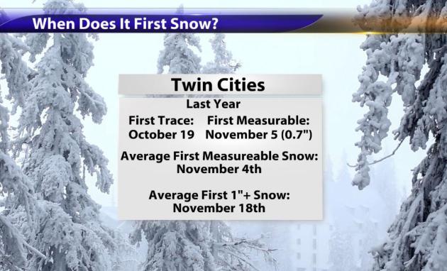
And yes, it’s early to be babbling about snow. At MSP the first measurable snow usually comes November 4.
Is another bitter winter imminent? Not necessarily. Stay upbeat.
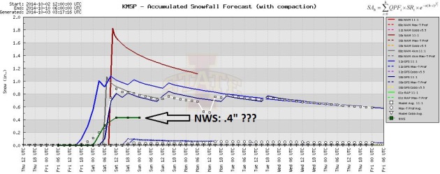
Not Buying It. I think a few snowflakes will mix with rain showers tonight, but with mild ground temperatures any snow should melt on contact in the Twin Cities. Will we wake up to a coating of slush at MSP Saturday morning? Possible, but I doubt it. The National Weather Service is predicting .4″ of slush late tonight. If soil temperatures weren’t so high I might be convinced. Graphic: Iowa State.
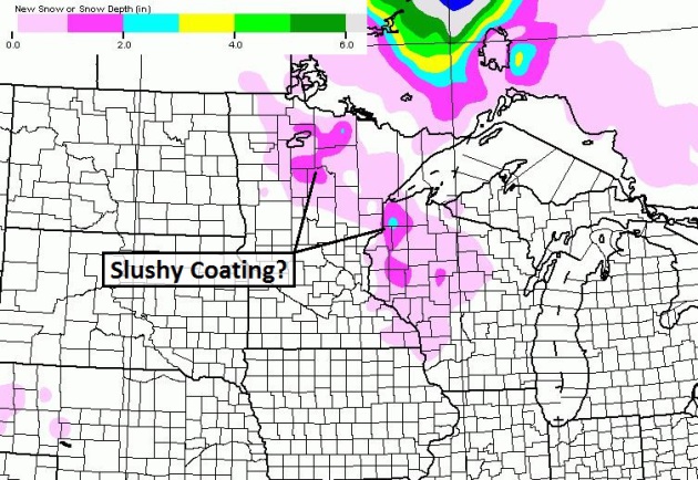
Slushy Lawns North/East of MSP. NOAA’s NAM model suggests a slushy half inch or inch from near Bemidji to Spooner and Hayward later tonight and early Saturday. Too early to dust off the snowmobile.
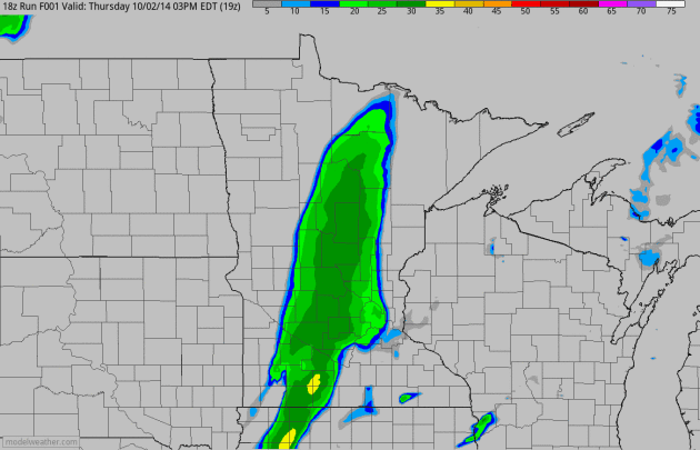
Instability Showers Arrive Tonight – Mixing With Wet Snow Late. NOAA’s 4 km NAM model shows a dry, windy start giving way to another surge of showers pushing from the Red River Valley into the metro; temperatures aloft cold enough for a little wet snow to mix in, but relatively warm ground temperatures should prevent a premature case of shock and awe Saturday morning. Future radar: HAMweather.
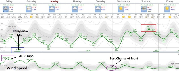
Today: Windiest Day. Models suggest sustained winds up around 20 mph today, with gusts as high as 35 mph as high velocity jet stream winds work their way down to ground level. Highs hold in the 30s Saturday, Sunday and Monday before slowly moderating next week; European guidance hinting at 60+ readings by Thursday. As winds subside under a high pressure bubble the best chance of a metro-wide frost may be Sunday morning.
* Twin Cities Marathon Weather: partly to mostly cloudy, breezy (but not as windy as today) with temperatures rising from the upper 30s into the 40s. No heat exhausion risk this year.
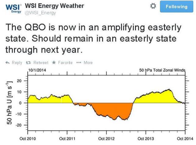
Negative Phase of QBO. What the heck is the QBO? It’s the Quasi-Biennial Oscillation, winds in the upper reaches of the atmosphere that correlate with where blocking patterns tend to set up over time. Last winter we experienced a strongly positive phase of the QBO, this year the phase trend is negative. Thus my suspicion (hope?) that we won’t have another winter with a temporarily stalled Polar Vortex. More background on QBO here. Tweet courtesy of WSI.
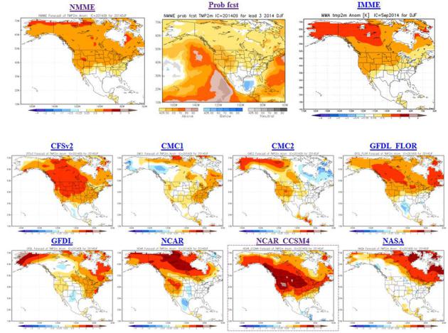
Long-Range Winter Model Guidance. Although we can’t predict specific weather for a specific date much beyond 7-10 days, it is possible to distinguish broad trends. The suite of various climate models above, valid December – February) show a uniformly milder than average bias for most of the North America during the heart of winter. Model data: NOAA NCEP.
Too Early For Snow Statistics. Wasn’t it just in the 80s? I’m still recovering from a late-season sunburn and now I have to jam in snow statistics? Not. Right. Soil temperatures are still in the 50s, so any wet snow that does fall late Friday night and early Saturday will probably melt on contact around the Twin Cities. But from St. Cloud to Brainerd? A little slush is possible there, maybe an inch or so near Bemidji.
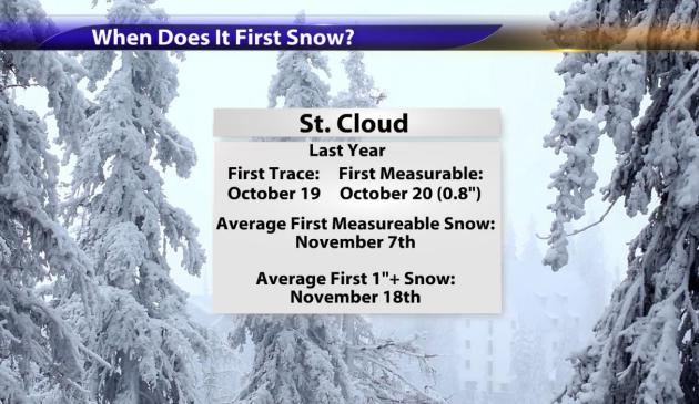
St. Cloud Stats. Last year the first flurries in St. Cloud were observed on October 19, nearly 1″ of snow fell on the 20th. That’s ahead of schedule. Long-term NOAA records show first measurable snow, on average, is November 7, the first 1″+ of snow not until November 18.
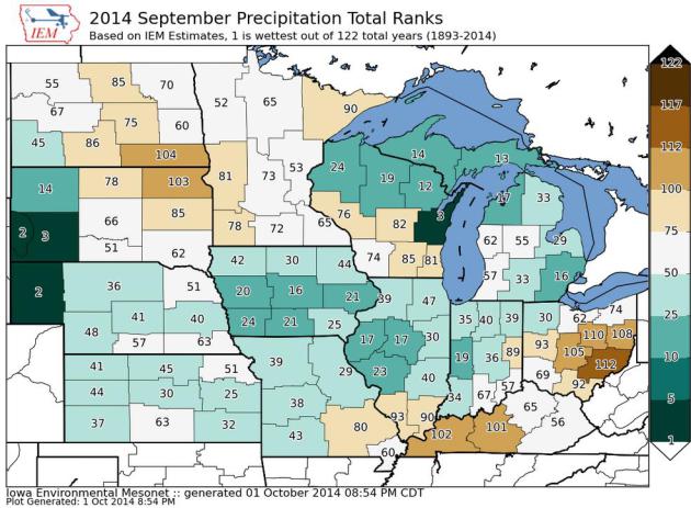
September Moisture Recap. I found this map from the Iowa Environmental Mesonet to be interesting; 53rd wettest September since 1893 for east central Minnesota, inicluding the Twin Cities, but the 3rd wettest of the last 122 years for the Green Bay area, southwwestern South Dakota and second wettest on record for the Nebraska Panhandle.
* The Minnesota DNR has more details about September here.
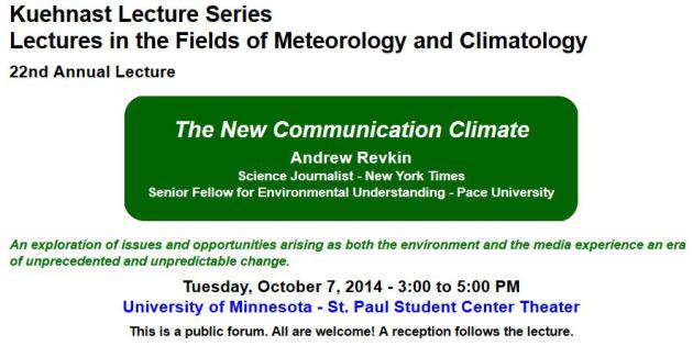
Andrew Revkin Is Coming to Minnesota. Author of The New York Times’s Dot Earth content, Revkin will be presenting at the University of Minnesota – St. Paul Student Center Theater next Tuesday, and all are welcome to attend. More details: “The Annual Kuhenast Lecture in Atmospheric and Climate Science is scheduled for October 7th, 3 p.m. at the St. Paul Campus Student Center theater. The 22nd Annual Kuehnast Lecture will feature author, musician, and award-winning journalist Andrew Revkin of The New York Times and Pace University. Revkin is known widely as the founder of the Dot Earth blog. His lecture, “The New Communication Climate,” will explore issues and opportunities arising as both the environment and the news media experience an era of unprecedented and unpredictable change. Refreshments will follow the program.”
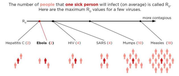
No, Seriously, How Contagious Is Ebola? NPR has a reassuring story – here’s an excerpt: “…Why is Frieden so sure this virus won’t spread beyond a handful of cases? It boils down to something called “R0.” The reproduction number, or “R nought,” is a mathematical term that tells you how contagious an infectious disease is. Specifically, it’s the number of people who catch the disease from one sick person, on average, in an outbreak.* Take, for example, measles. The virus is one of the most contagious diseases known to man. It’s R0 sits around 18…” (Image credit: Adam Cole, NPR).
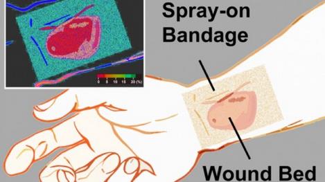
“Smart” Bandage Glows To Indicate How Well Wounds Are Healing. I still want my flying car and robotic butler, but I guess this will have to suffice for “progress” in the near term. Gizmag.com has the story – here’s an excerpt: “When a person’s skin is burnt or otherwise injured, part of the body’s healing process involves boosting oxygen levels in the damaged tissue. If doctors treating such injuries know how high those levels are, then they can determine how quickly and thoroughly the skin is healing. In order to help them obtain that information without having to remove the wound dressing, an international team of scientists has created a glowing paint-on bandage…”

Ultimate Coffee Fan Spends 17 Years Visiting Every Starbucks In The World. I’m feeling better about my coffee addiction; and I really want to sign up for a similar gig. Maybe visit every sugar-sand beach in the world? Who’s funding this caffeine-infused junket? Sign me up. Here’s an excerpt from The Telegraph: “A coffee fan from Texas has spent more than $100,000 visiting 11,733 Starbucks across six different continents, although he admids he wouldn’t recommend the coffee. Winter, who has legally changed his name from Rafael Lozano, came up with the idea while sitting at a Starbucks in Plano, Texas, in 1997…”
Photo credit above: “Winter has visited 11, 733 Starbucks so far.”


Who’s Real Enough for Facebook? You just can’t make this stuff up. I want to hear more about Lil Miss Hot Mess though, I have to admit. Here’s a clip from a story at The New Yorker: “In early September, some well-known drag queens in San Francisco, Sister Roma and Lil Miss Hot Mess, received startling messages from Facebook. Their accounts had been suspended because they were using their drag names, which Facebook didn’t consider “real.” Facebook has, since its inception, in 2004, required that people use their “real names” on the site—by Facebook’s definition, this means using your name “as it would be listed on your credit card, driver’s license or student ID...”
Photo credit above: “Lil Miss Hot Mess, Sister Roma, and Heklin speaking about their battle with Facebook during a news conference in San Francisco.” Credit Photograph by Eric Risberg/AP.

“Invisaband” Bracelet Claimed To Make You Undetectable to Mosquitoes. A cloaking device for skeeters? I know, I’ll believe it when I see it. Now if you can just modify this to work with spouses and in-laws. Here’s a clip from Gizmag: “Lathering yourself in smelly, mosquito-repelling lotions might not be ideal, but it’s better than those itchy red swellings that pop up on any skin left exposed …. not to mention the fact that these blood-sucking pests are better than most when it comes to spreading deadly diseases, such as malaria. The Invisaband is a bracelet that releases a natural oil claimed to confuse a mosquito’s senses, saving you from their irritable bites and the need to apply layers of oily repellents…”
TODAY: Very windy and raw with mainly PM showers. Winds: NW 25+ High: 48
FRIDAY NIGHT: Rain may mix with a little wet snow in the metro. Some slush may accumulate on lawns/fields from near St. Cloud to Brainerd and Bemidji late. Low: 36
SATURDAY: Hello November! Mostly cloudy with a stiff breeze. High: 47
SUNDAY: Partly sunny, still brisk. Wake-up: 35. High: near 50
MONDAY: Clouds linger – chilly. Wake-up: 37. High: 49
TUESDAY: Mostly cloudy. No sign of October. Wake-up: 38. High: 50
WEDNESDAY: Frosty start. More sun, less wind. Wake-up: 31. High: 59
THURSDAY: Fading sun, more seasonable. Wake-up: 48. High: 62
* Photo credit above: Heidi Rusch in Minnetonka.
Climate Stories…

When Can A Big Storm or Drought Be Blamed on Climate Change? A critically important question: what are random (normal) swings in wild weather vs. extremes turbocharged by a warmer, wetter climate? Here’s an excerpt from an interesting article at NPR: “…That sort of discernment is difficult, so scientists have had a rule, a kind of mantra: You can’t attribute any single weather event to climate change. It could just be weird weather. Then they took a close at last year’s heat wave in Australia. The chances that the continent’s extreme temperatures reflected normal variation is “almost impossible,” says Peter Stott, a climate scientist at the Hadley Center of the Met Office, in Exeter, Great Britain. “It’s hard to imagine how you would have had those temperatures without climate change,” he says. Stott is one of a group of researchers analyzing the patterns of “extreme weather” events in the past and comparing them with the patterns Earth is experiencing now. The intensity of last year’s Australian heat wave was statistically “off the charts,” he says. Climate change had to be behind it…” (Image: Environment America).
Climate Change Is Threatening Our Health. Here’s an excerpt from a physician’s Op-Ed at thestar.com: “In 2009, the Lancet called climate change the “biggest global health threat of the 21st century.” Many physicians, myself included, were surprised by this diagnosis. Bigger than cancer? Heart disease? Really? Since then floods have flattened crops and swamped cities, putting more people at risk of trauma, food insecurity, displacement and mental health issues. Heat waves have exhausted our elderly, Lyme disease is marching across our country and wildfires tore through forests near my home in Yellowknife, filling our skies with gloomy smoke and our ER with wheezy, breathless people. Climate change is shifting health problems that we already struggle with the wrong way on the probability curve…”
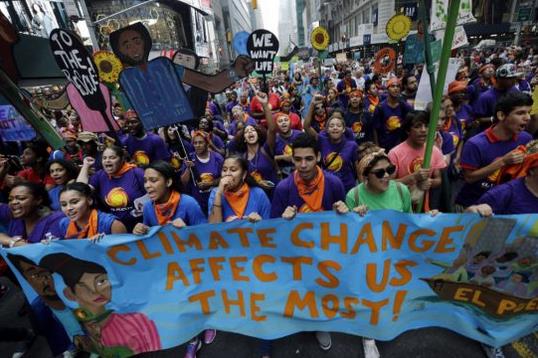
Photo credit above: Mel Evans, AP. “Thousands of demonstrators filled the streets of Manhattan to participate in a climate change march on Sept. 21, 2014, urging policy-makers to take action.”
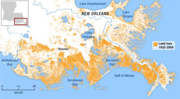
Louisiana Is Disappearing Into The Sea. New Republic takes a look at land subsidence and rising seas impacting the vanishing marshlands of Louisiana; here’s a clip: “…Louisiana is disappearing. Since 1932, the Gulf of Mexico has swallowed 2,300 square miles of the state’s wetlands, an area larger than Delaware. If no action is taken, the missing Delaware will become a missing Connecticut, and then a missing Vermont. The loss of the marshes has catastrophic implications, because they are the state’s first, and strongest, defense against hurricanes...”
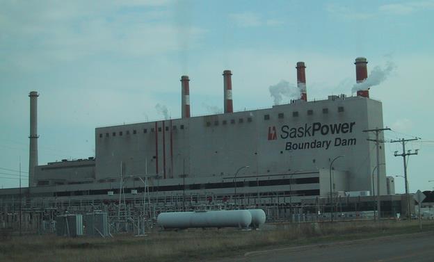
Canada To Start First Carbon-Capture Coal Power Plant. It remains to be seen whether coal-fired CO2 can be cost-effectively buried deep underground. Here’s an excerpt from Bloomberg: “Canada is poised to open the first large-scale power plant that will burn coal while cutting carbon emissions by 90 percent, part of an effort to continue the use of fossil fuels without worsening global warming. SaskPower International Inc., Saskatchewan’s province-owned utility, will officially start the C$1.35 billion ($1.2 billion) Boundary Dam power plant tomorrow, said Tyler Hopson, a spokesman for the company. The 110-megawatt project will cut carbon dioxide emissions by about 1 million metric tons annually, by trapping it before it enters the atmosphere and pumping it underground...” (File photo: Wikipedia).

We Don’t Need Perfect Knowledge To Act on Climate Change. A couple of distinguished climate scientists respond to a recent Op-Ed in The Wall Street Journal; here’s an excerpt: “…Uncertainties in projections of 21st century climate change shouldn’t be an excuse for policy inaction. The longer we delay concerted action to reduce emissions of greenhouse gases, the more difficult it will be to avoid dangerous interference with the climate system. Time is a luxury we don’t have. We welcome the constructive collaboration of the physics community in improving our understanding of the human fingerprint on climate…”
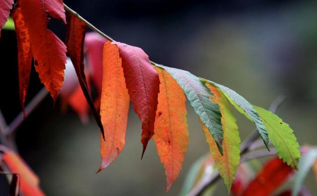
How Will Climate Change Affect Fall Foliage? Modern Farmer takes a look at how shifting seasons are impacting the timing and intensity of peak fall color; here’s the introduction: “Researchers at Princeton University recently took a deep dive into the lovely autumnal colors of the Northeast and Midwest with an eye on climate change. They found that as the planet heats up, fall foliage will respond in messy, unpredictable ways — and that as a whole, leaves will begin changing color later and the period in which bright orange, red and yellow leaves stay on trees will last longer. But even though tourists in Vermont may celebrate, it’s important to note that the researchers’ findings indicate changes that could extend beyond fall photo ops. Trees, as it turns out, are the canary in the coal mine…”
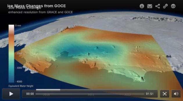
Antarctica Has Lost Enough Ice To Cause A Measurable Shift in Gravity. Here’s a clip from a story at Slate and WIRED: “…The biggest implication is the new measurements confirm global warming is changing the Antarctic in fundamental ways. Earlier this year, a separate team of scientists announced that major West Antarctic glaciers have begun an “unstoppable” “collapse,” committing global sea levels to a rise of several meters over the next few hundred years. Though we all learned in high-school physics that gravity is a constant, it actually varies slightly depending on where you are on the Earth’s surface and the density of the rock (or, in this case, ice) beneath your feet...”
