96 F. high in the Twin Cities Saturday, 2F away from tying the old record.
82 F. average high on June 25.
82 F. high on June 25, 2015.
June 26, 1982: Cold air moves into northern Minnesota. Kulger Township dips to 31 degrees. Duluth registers 36.
Trickle-Down Technology & Accidental Discoveries
Future grandkids will grow up believing we always had weather apps and radar on our phones. We’ve come a long way since Amish Doppler (staring out the window).
A race to space following launch of The Soviet Union’s Sputnik satellite in 1957 had a Cold War weather dividend: “Tiros-1” began sending back grainy weather imagery from low Earth orbit in 1960.
Radar operators tracking enemy planes during WW II noticed smudges of interference on their screens. They thought it was a bug – turns out they were seeing precipitation, not German aircraft; a happy discovery that has evolved into today’s high resolution Doppler radar.
The older I get, the less I take for granted.
Yesterday’s 100-degree heat index and severe storms are history; a fresh west wind treats us to blue sky today, with a crisp dew point in the 50s (and no blobs on Doppler).
While the western USA fries a series of Canadian cool fronts flirt with Minnesota into next weekend with highs in the 70s, lows in the 50s. Free A/C.
Amazingly, models hint at a few T-showers on the 4th of July, highs near 80F. What can go wrong?
Cool for Late June and Early July. I’m not complaining, but there may be some in our midst (you know who you are) who will gripe about “chilly conditions” next weekend with highs in the 70s – a few degrees cooler than average. I hope that predicted high of 65F next Tuesday (July 5) is an ECMWF typo. Source: WeatherBell.
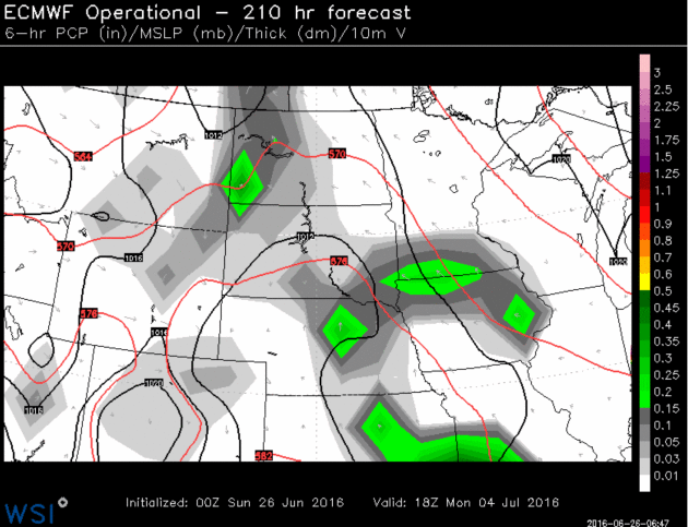
ECMWF Outlook for 4th of July. I’m amazed when it doesn’t rain on the 4th of July. It’s a tradition, being chased from boats, parades and fireworks displays, by angry mobs of swollen clouds flashing lightning bolts and ragged chunks of ice (hail). Saturday night’s 00z run shows a few T-showers pushing in from the south at midday on the 4th of July. Again, what can possibly go wrong? Map: WSI.
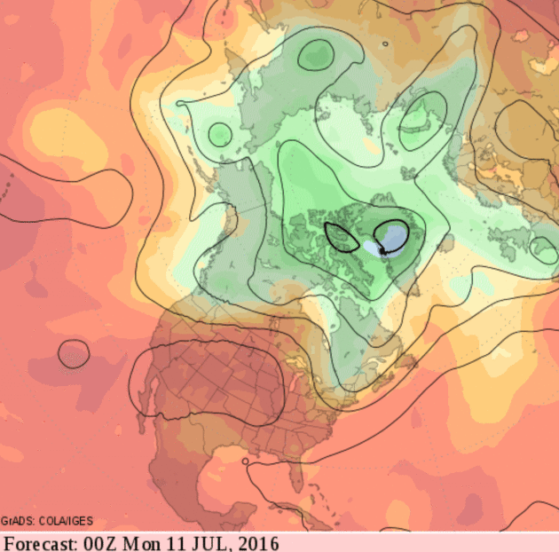
From Cool & Comfortable to Hot & Sweaty Second Week of July? Our on-again, off-again heat wave appears to be on-again, at least if you buy the 2-week 500 mb forecast, courtesy of NOAA’s GFS model, predicting the heat bubble gripping much of the west and southwest will expand across the Plains into the Midwest. If this verifies we’ll see an extended period of highs in the 90s.
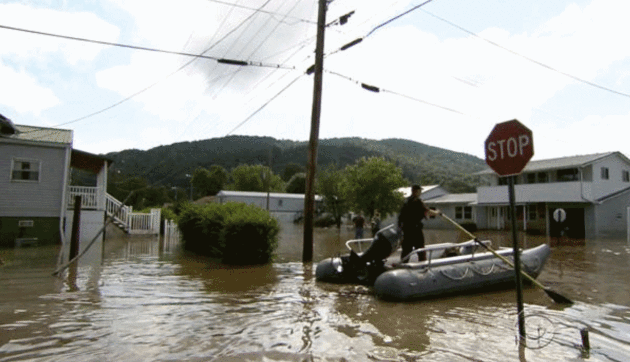
Trooper: Flood-Damaged West Virginia “Looks Like a War Zone”. Here’s an excerpt from CBS News: “…It looks like a war zone when you go inside these houses,” State Trooper C.S. Hartman told CBS News. He worried that among the destruction will be more bodies. “That’s the last thing I want to do, but we’re prepared for it,” Hartman said. The once-a-century flood left the small town of Clendenin mostly underwater. Forty-four of West Virginia’s 55 counties were inundated. The National Guard and FEMA have been called in to help. Thousands are without power. At least 100 homes suffered significant damage or were destroyed…”
Photo credit: “West Virginia State Trooper C.S. Hartman uses a boat to navigate the flooded streets of Rainelle, W. Va., on Saturday, June 25, 2016.” CBS News.
PGA Cancels Greenbrier Classic Amid West Virginia Flood. U.S. News has more details: “The PGA Tour announced Saturday that the Greenbrier Classic scheduled for next month has been canceled because of the devastating flooding in West Virginia. The tournament had been scheduled for July 7-10 at the Greenbrier Resort in White Sulphur Springs, which was inundated with floodwaters after heavy storms rolled into the state Thursday. Tour officials say the Old White TPC, the host course, suffered extensive damage and “is beyond reasonable repair to conduct the tournament…”
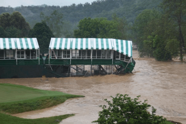
Photo credit: “This Thursday June 23, 2016 image provided by the Greenbrier shows flooding on the 18th green of the Old White Course at the Greenbrier in White Sulphur Springs, W. Va. Severe flooding hit the area that is scheduled to host a PGA tour event in two weeks.” (Cam Huffman/The Greenbrier via AP) The Associated Press
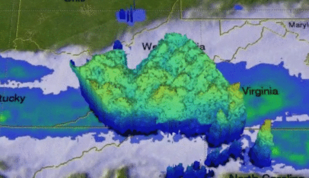
NASA Analysis of West Virginia Flood Event. Another 1-in-1,000 year rainfall event? Once again weather systems essentially stalled, with training storms dropping repeated bouts of heavy rain over the same (waterlogged) counties. Here’s an excerpt from
NASA’s Precipitation Measurement Missions: “…
GPM captured this image of the East-West oriented line of storms at 9:41 pm EDT on Thursday June 23rd (01:41 UTC 24 June 2016). The image shows rain rates derived from the GPM GMI (outer swath) and DPR (inner swath) overlaid on enhanced IR data from the GOES-East satellite. By this time, most of the heavy rain was located over southern Virginia along the border with North Carolina where rates are shown to exceed 50 mm/hr (~2 inches/hr, shown in dark red). Meanwhile a broad area of light to moderate rain (blue and green areas) stretches from the Atlantic Coast all the way through southern West Virginia and back into central Kentucky.…”
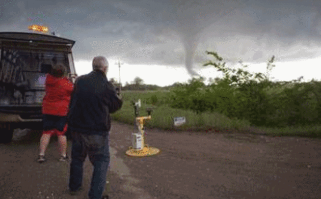
Atmospheric Scientists Boldly Go Into The Heart of a Tornado. The
National Science Foundation has the story; here’s an excerpt: “…
TWIRL’s field season ran from May 1 through June 15. That’s the time of year when two ingredients required for tornadoes — very unstable air and strong vertical wind shear — are most common. The TWIRL scientists are developing 3-D maps of the strongest tornado winds near the ground, and studying how these winds cause damage to buildings, power lines, trees — and anything else in their way. “TWIRL researchers are focusing on low-level winds flowing into the cores of tornadoes,” said Ed Bensman, program director in NSF’s Division of Atmospheric and Geospace Sciences, which funds TWIRL…”
Photo credit: “TWIRL researchers get a tornado pod set-to-go; a tornado is about to pass by.” Credit: Center for Severe Weather Research/Robin Lorenson.
Could a United Kingdom Exit From The EU Affect Weather Forecasts? What, if any, effect on ECMWF, the world’s leading weather model? Here’s an excerpt of a post from Dr. Marshall Shepherd at
Forbes: “…
I have no insight on how this vote affects the weather community but a “common sense” twitch in me suggests there could be some effects. While that ultimately remains to be seen, there are aspects worth noting about the United Kingdom (UK) and European Union as they pertain to the global weather enterprise. It is well-known in weather circles that the European Center for Medium-Range Weather Forecasting (ECMWF) or “Euro” model is the leading weather forecasting model in terms of numerous metrics for skill. I am often amused at the passionate discussion about this...”
* Here’s a link to a
statement from ECMWF about England’s decision to leave the EU.
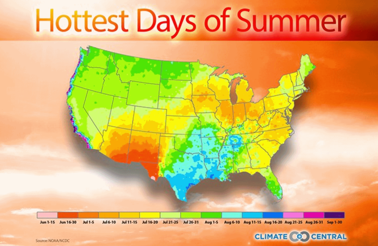
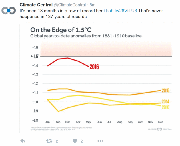
Hottest Days Come in Mid-July. It may seem counterintuitive, but the hottest weather doesn’t come on the Summer Solstice, when the sun angle is highest in the sky. There is a built-in “lag” in the atmosphere, as water takes longer than land to heat up, and historically the hottest days of summer come 2-3 weeks after the solstice, in mid-July. Graphic credit: Climate Central.
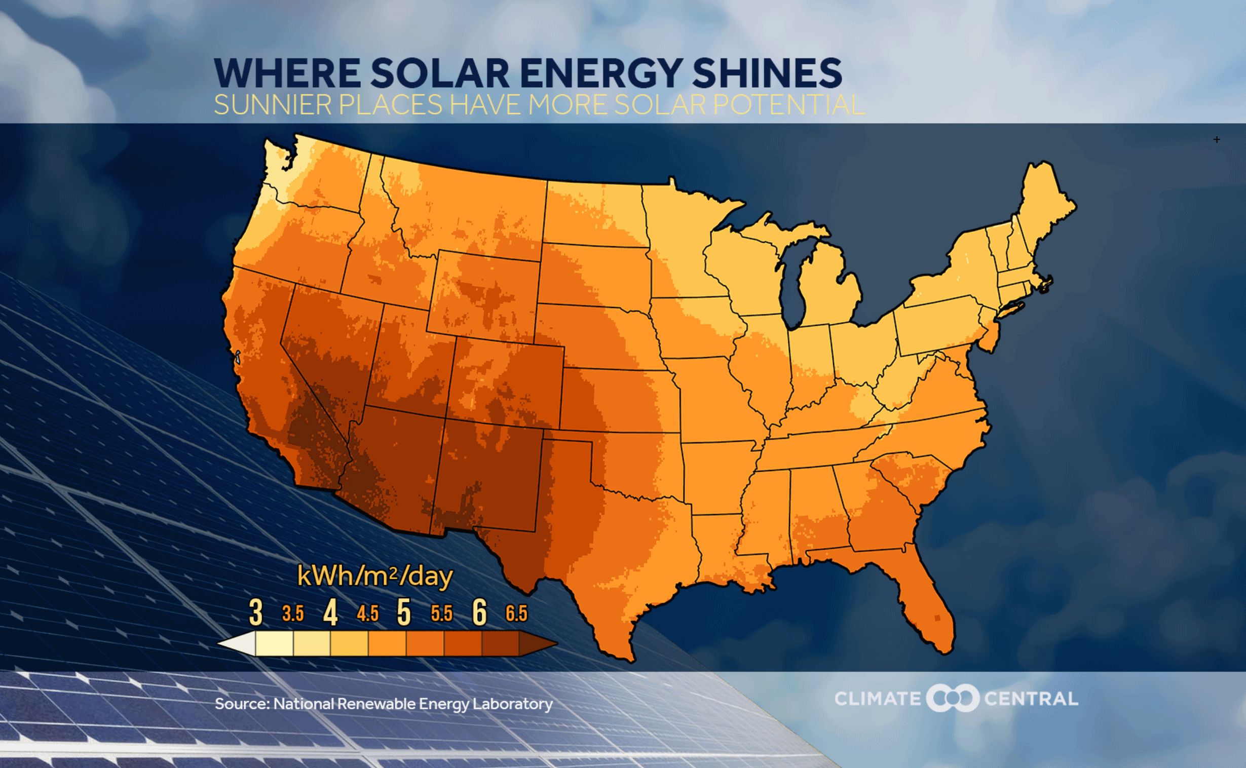
Here’s Where Solar Energy Shines in the U.S. Climate Central has the story – here’s a clip: “…
The price paid for electricity varies across the country, depending on how it is generated and other factors. But according to the Department of Energy, the average national price of electricity to residential customers is about 12 cents per kWh. If a home gets 400 kWh a month from solar, it would cut the annual energy bill for the average home by around $600. Since 2008, the cost of generating electricity from solar panels has been cut in half. The number of U.S. solar installations have increased by a factor of 17 over that period, and they now have the capacity topower the equivalent of 4 million average American homes. With solar panel costs expected to continue falling, solar energy may become an increasingly attractive proposition to homeowners…”
American Drivers Regain Appetite for Gas Guzzlers. Here’s the intro to a New York Times story: “The single most effective action that most Americans can take to help reduce the dangerous emissions that cause climate change? Buy a more fuel-efficient car. But consumers are heading in the opposite direction. They have rekindled their love of bigger cars, pickup trucks and sport utility vehicles, favoring them over small cars, hybrids and electric vehicles, which are considered crucial to helping slow global warming...”

After Thousands of Years, Earth’s Frozen Life Forms Are Waking Up.
Gizmodo reports: “…
Cryofreezing is best known for its appearances in science fiction, but self-styled “resurrection ecologists” are now showing the world just how real it is. In 2012, scientists germinated flowers from a handful of 32,000 year old seeds excavated from the Siberian tundra. Last year, researchers hatched 700-year old eggs from the bottom of a Minnesota lake, while another team resuscitated an Antarctic moss that had been frozen since the time of King Arthur. Bacteria, however, are the uncontested masters of cryogenics—one bug, at least, was alive and kicking after 8 million years of suspended animation...”
TODAY: Sunny, less humid. Winds: W 10-20. High: 85
SUNDAY NIGHT: Partly cloudy and comfortable. Low: 62
MONDAY: Mix of clouds and sun, cool wind. Winds: NW 10-20. High: 73
TUESDAY: Bright sunshine, less wind. Winds: NW 3-8. Wake-up: 55. High: 76
WEDNESDAY: Partly sunny, still pleasant. Winds: S 7-12. Wake-up: 60. High: 78
THURSDAY: Chance of showers, possible thunder. Winds: NW 10-15. Wake-up: 63. High: 82
FRIDAY: Partly sunny, comfortable. Winds: NW 7-12. Wake-up: 63. High: 78
SATURDAY: Touch of September. Cool and crisp. Winds: NE 10-15. Wake-up: 59. High: 75
Climate Stories…
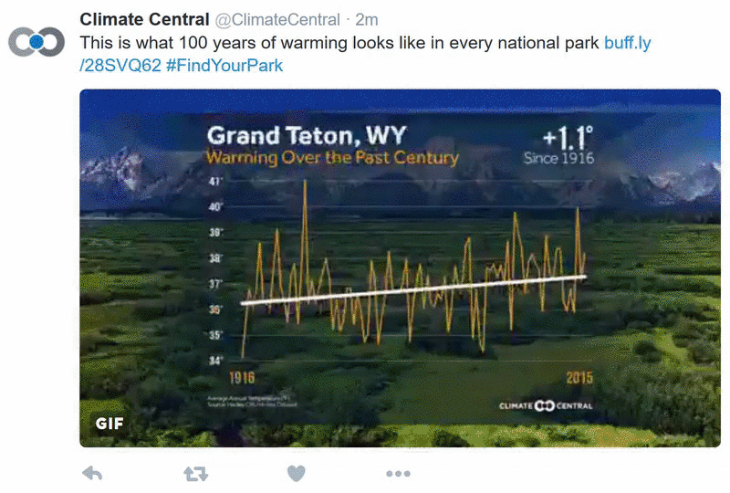
Climate Change is the National Parks’ Biggest Challenge. Climate Central takes a look at new challenges within “America’s Best Ideas”, our parks: “…Rising temperatures, an increase in extreme dry years and disappearing snowpack are altering the conditions that have allowed these trees to thrive for eons in a thin band along the Sierras’ western flank. The ongoing California drought has hit the southern Sierras hard and increased the risk of more destructive wildfires, and less water availability in the summer. Researchers have already documented a dieback in older trees during the drought, one of the many “a-ha moments” that point toward future challenges for the Giant Forest. The average annual temperatures in the park are projected to rise around 7°F by 2100 if carbon pollution isn’t slowed, further disrupting a delicate balance...”

Why the GOP is Trying to Stop the Pentagon’s Climate Plan. Politico attempts to explain the inexplicable; here’s an excerpt: “…
This is what we ask our military and national security people to do, to think long-term, look at emerging threats, figure out ways to protect against these threats,” he said. DOD officials have been warning for years that climate change could have dire consequences on U.S. national security. Increased refugee flows, which are already straining Europe, are likely to accelerate as the climate heats up and have the potential to destabilize large swaths of the world, including the Middle East and South Pacific. The “oil wars” of the 20th century could give way to “water wars,” with countries competing for scarce natural resources. Higher energy costs may further strain the military’s budget and rising water levels could force the DOD to adjust locations of critical infrastructure facilities like ports…”
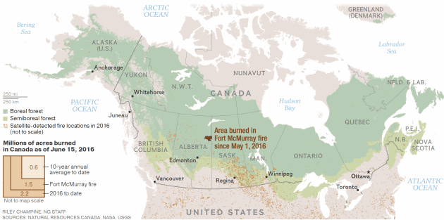
Forest Fires Can Heat Up The Whole Planet. A story at
National Geographic explains how NASA is tracking the accelerating changes: “…
Climate change is playing out twice as fast in the boreal forest than it is on the rest of the planet. Permafrost is thawing, and vegetation is changing as climatic zones migrate north faster than trees can adapt. Already, dramatic change can be glimpsed from space: The tundra is turning green, while the boreal forest is turning brown. Some scientists predict the boreal forest may reach a disastrous—and irreversible—tipping point this century and shift from carbon storehouse into a major source of greenhouse gas emissions. Others contend that the tipping point has already been reached...”