65 F. high in the Twin Cities Tuesday.
67 F. average high on September 26.
66 F. high on September 26, 2016.
September 27, 1942: Minneapolis has a high temperature of only 40 degrees.
September 27, 1898: A heat wave produces highs of 91 degrees at Beardsley and 90 at Moorhead.
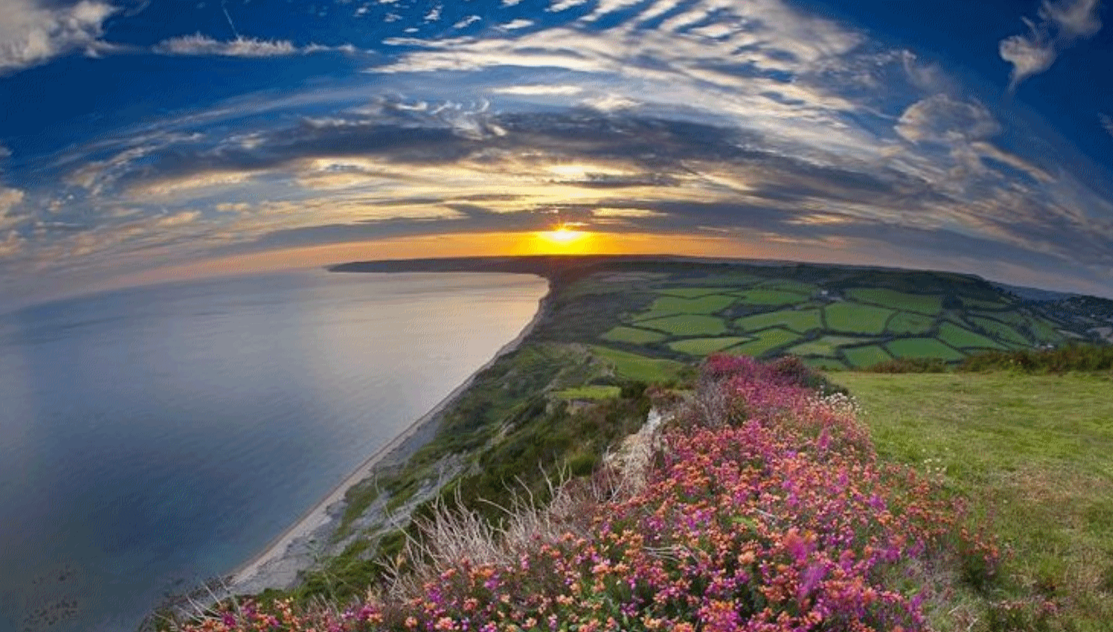
A Little Fog – A Little Sun – Relatively Quiet
“We know that in September, we will wander through the warm winds of summer’s wreckage. We will welcome summer’s ghost” wrote Heny Rollins. I love a good Minnesota summer. Even the bad ones are worth savoring, but there’s something about our increasingly super-sized autumns that rubs people the right way.
It’s almost as if Mother Nature scheduled a reluctant intermission, sandwiched between raging thunderstorms and snowy clippers to come.
Our latest stormy swirl is long gone, with sunshine the rule into Saturday. Most of us won’t see rain until Sunday, when the next frontal boundary arrives with showers and thundershowers. ECMWF (European) guidance shows another run of 80s by the middle of next week. I don’t think the metro area will enjoy another 100F heat index this year, but more shorts-worthy warmth is likely as we push into October.
September is prime time for lazy clouds, or fog, resulting from long nights and lingering moisture in the atmosphere – most likely after a sloppy front.
That’s about as exciting as our weather will get anytime soon. I’m OK with that.
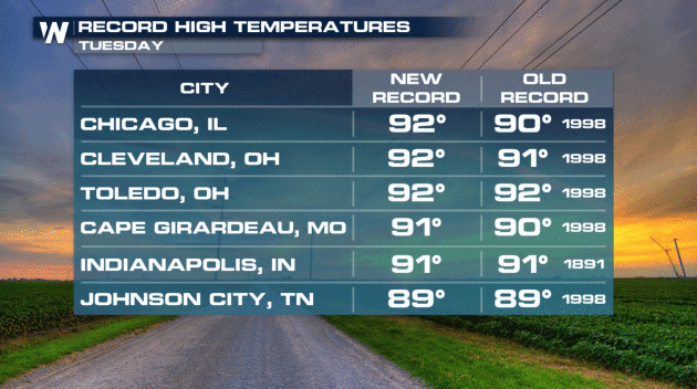
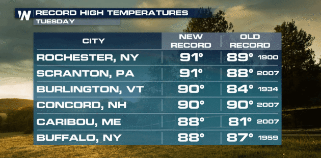
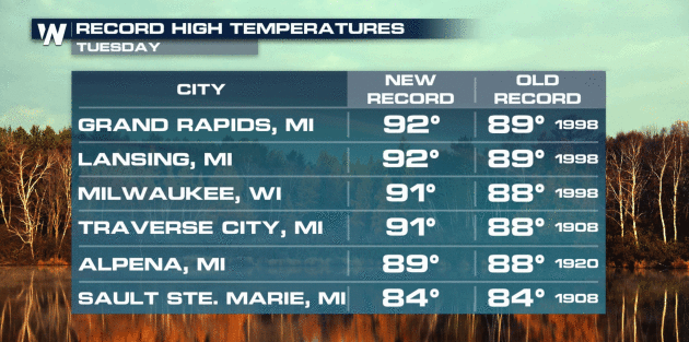
Early July in Late September. It was a stinking hot Tuesday across the eastern half of the USA. Record highs courtesy of WeatherNation.
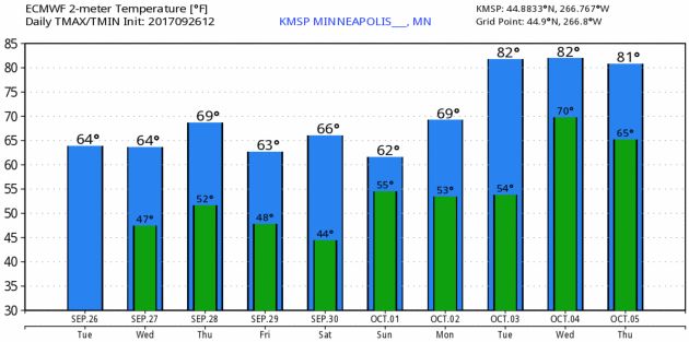
Another Summer Rerun? ECMWF guidance for the Twin Cities shows highs in the 60s through the weekend, but another surge of warm, sticky aiir may push into Minnesota by the middle of next week with more 80s. Shorts and jackets – in the same closet. Graphic: WeatherBell.
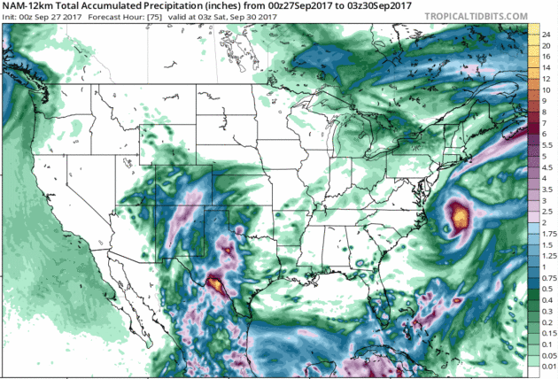
Rainfall Potential Thru Friday Night. Heaviest rains are forecast to soak the Rio Grande Valley of Texas with as much as 10″ in a few spots. Most of the west and Midwest remains dry; Maria (mercifully) pulling out into the Atlantic. 12 KM NAM accumulated rainfall product: NOAA and Tropicaltidbits.com.
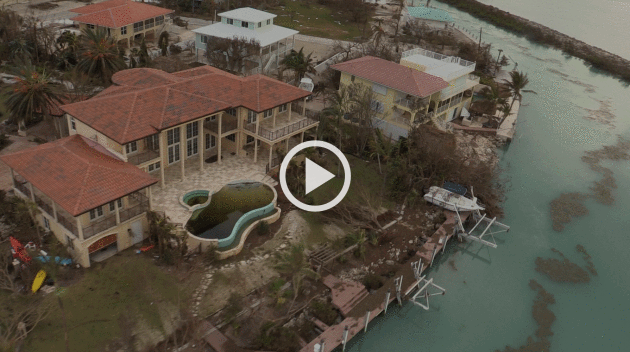
Disconnected by Disaster: Photos From a Battered Puerto Rico. The Atlantic has a story that shows Maria’s impact on Puerto Rico: “Five days after Hurricane Maria made landfall in Puerto Rico, its devastating impact is becoming clearer. Most of the U.S. territory currently has no electricity or running water, fewer than 250 of the island’s 1,600 cellphone towers are operational, and damaged ports, roads, and airports are slowing the arrival and transport of aid. Communication has been severely limited and some remote towns are only now being contacted. Jenniffer Gonzalez, the Resident Commissioner of Puerto Rico, told the Associated Press that Hurricane Maria has set the island back decades...”

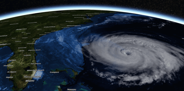
*Maria continues to cling on to hurricane strength this morning, with sustained winds of 75 mph. Maria continues to be a large system with tropical storm force winds extending outward 240 miles from the center.
*Maria will continue to parallel the U.S. coast over the next 24-48 hours before getting quickly nudged east away from the mainland. The forecast path also takes Maria far north of Bermuda.
*While the core of Maria will remain offshore, tropical storm force winds are still expected due to the wide wind swath of this storm. Wind gusts of 55 mph will be possible through Wednesday for areas under a Tropical Storm Warning, which includes Bogue Inlet to the North Carolina/Virginia border including Albemarle and Pamlico Sounds.
*A storm surge of 2-4 feet will also be possible at high tide, especially along the sound side of the Outer Banks. Due to this, a Storm Surge Watch is in effect for Cape Lookout to Duck.
*High surf and the threat of rip currents will continue along the East Coast this week due to Maria. Rainfall amounts from this system are expected to be light, with 1-2” possible for the Outer Banks.
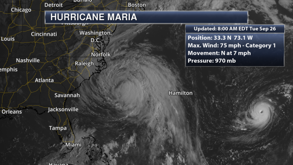
Maria This Morning. Maria continues to hold on to hurricane strength this morning, even though the system is being affected by cooler waters and some upper level winds. As of 8 AM ET, Maria was sitting 190 miles southeast of Cape Hatteras, NC, and moving north at 7 mph.
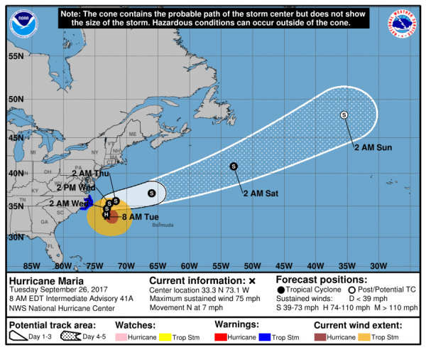
Official Maria Track. A steady (and somewhat slow) northward movement is expected over the next 24-48 hours as Maria continues to parallel the U.S. East Coast. As it does so, it would make its closest approach to the coast – although still far offshore – into Wednesday. Maria is also expected to weaken into a tropical storm during this period. By Thursday, Maria should receive a shove off to the east, and the forward motion of the system will rapidly increase.
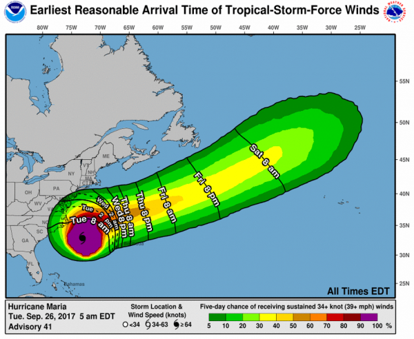
Timing Tropical Storm Force Winds. Conditions will start to deteriorate today across portions of the Mid-Atlantic Coast, including in the Outer Banks as tropical storm force winds arrive.
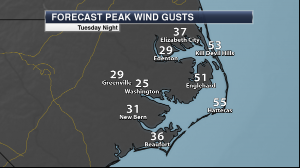
Wind Gusts Up To 55 MPH. The strongest wind gusts are expected along the Outer Banks with Maria, where winds could gust over 50 mph. Some of the strongest wind gusts for places like Hatteras and Kill Devil Hills will occur tonight.

Tropical Storm Warnings. Due to mainly the wind threat from Maria, Tropical Storm Warnings have been issued for parts of North Carolina, including the Outer Banks. Along the coast, these warnings include the following locations:
* Bogue Inlet to the North Carolina/Virginia border
* Albemarle and Pamlico Sounds
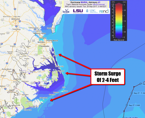
Storm Surge Potential. The large wind field will help to produce the potential of coastal flooding from storm surge, especially along the sound side of the Outer Banks. A storm surge of 2-4 feet will be possible – mainly at high tide – over multiple tide cycles.
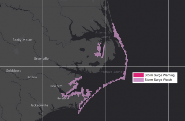
Storm Surge Watch. Due to the potential of storm surge flooding, a Storm Surge Watch has been issued for the following coastal locations:
* Cape Lookout to Duck
Summary: While Maria will continue to pass far offshore the U.S. East Coast through the middle of the week, some tropical storm impacts from this large system will be felt in far eastern North Carolina, including the Outer Banks. Winds will gust over 50 mph at times, especially in the Outer Banks, with sustained tropical storm force winds expected. Due to this wind threat, Tropical Storm Warnings are in effect from Bogue Inlet to the North Carolina/Virginia border including Albemarle and Pamlico Sounds. Storm surge flooding of 2-4 feet – especially at high tide – can be expected along the coast, especially on the sound side of the Outer Banks. Maria will continue to move north over the next 1-2 days before getting a quick push off to the east.
Meteorologist D.J. Kayser, Praedictix
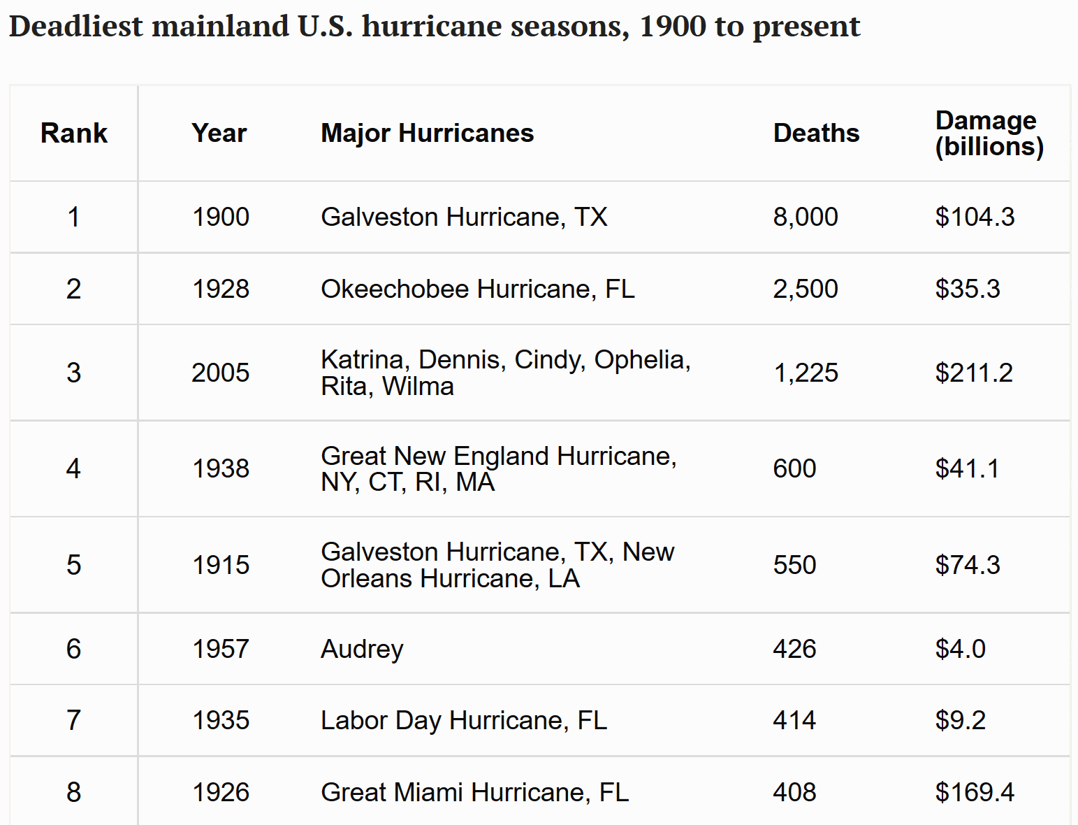
Is This the Worst Hurricane Season Ever? Here’s How it Compares. Relatives of people who died in the great Galveston Hurricane of 1900 might beg to differ. Details via TIME.com: “The deadliest natural disaster in U.S. history is also the most fatal hurricane to date. In 1900, inaccurate predictions, combined with poor warning systems, left Galveston, Texas vulnerable to a hurricane that killed between 6,000 and 12,000 people. Twenty-eight years later, an estimated 2,500 people drowned when a Category 4 hurricane caused Lake Okeechobee in Florida to overflow, deluging the surrounding area with 10-to-15-foot floods. The 10 deadliest hurricane seasons include only one from within the past 50 years: 2005, when Hurricane Katrina overwhelmed the levees in New Orleans and inundated the city, killing more than 1,000 people…”
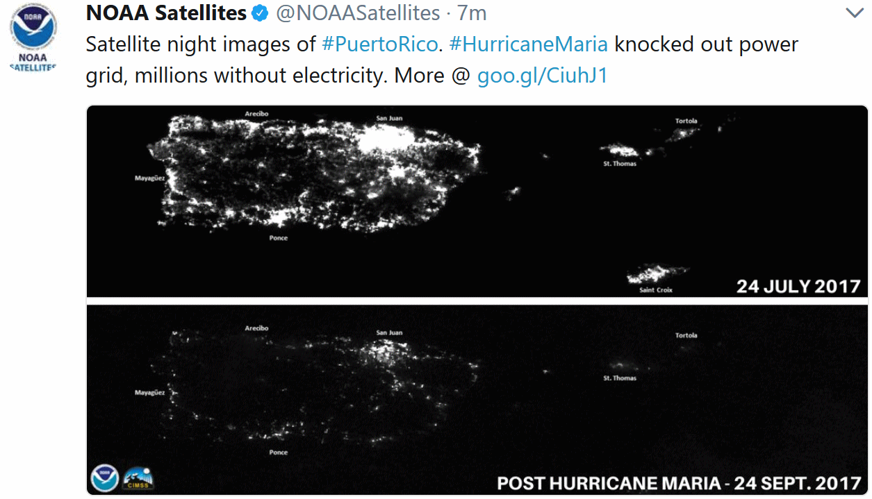
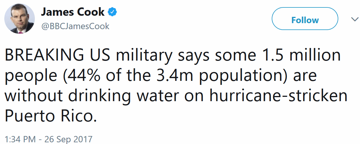
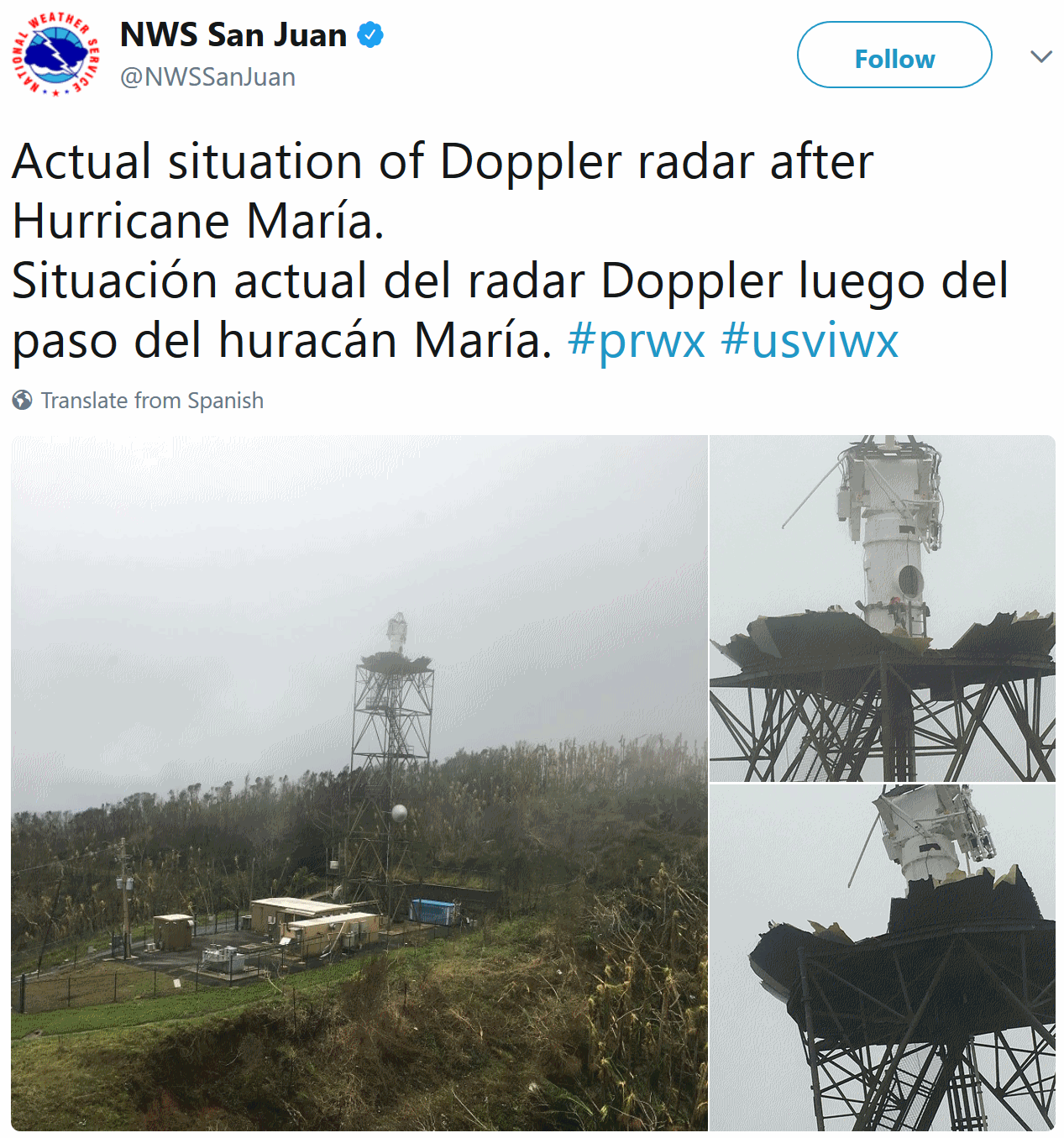
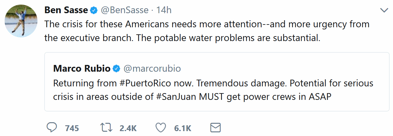
Puerto Rico’s Devastation Grows: Climate Nexus reports: “Puerto Rico’s humanitarian crisis continued to grow over the weekend, as officials describe “apocalyptic” conditions across the island in the wake of Hurricane Maria. Many of the 3.4 American citizens living on the island are without power and disconnected from communications, and officials estimate some areas won’t see power restored for months. Isolated towns and low-income communities are facing increasing shortages of supplies and fuel. Officials estimate the storm also destroyed around 80 percent of the island’s crop value, while a dam compromised by heavy rain is causing worries about flooding and accessibility of drinking water. “The devastation in Puerto Rico has set us back nearly 20 to 30 years,” Jenniffer Gonzalez, the island’s nonvoting representative in Congress, told the AP.” (Conditions: CNN, AP, Washington Post $, Bloomberg, New York Times $. Communications & power: NPR, Vox, NBC. Agriculture: New York Times $. Dam: New York Times $, Reuters, NBC, USA Today, CNN. Commentary: New York Times editorial $)
How You Can Help Hurricane Victims in Puerto Rico. We all need to step up and help fellow Americans. PBS NewsHour explains how you can help: “…Most organizations are asking for cash, rather than supplies, so they can route help to where it’s needed most more quickly. Here are some of the largest groups with campaigns underway:
- United for Puerto Rico (spearheaded by the First Lady of Puerto Rico)
- UNICEF
- Center for Popular Democracy
- Hispanic Federation’s “Unidos” page
- Former U.S. presidents have expanded their One America Appeal to include recovery efforts in Puerto Rico and the U.S. Virgin Islands
- All Hands Volunteers
- Catholic Relief Services
- Americares
- Direct Relief
- Save the Children, which focuses specifically on the needs of families and their children.
- Global Giving has a $2 million goal for victims of Hurricane Maria…”
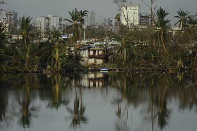
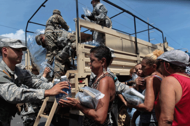
Photo credit: “Soldiers of Puerto Rico’s national guard distribute relief items to people, after the area was hit by Hurricane Maria in San Juan, Puerto Rico.” Photo by REUTERS/Alvin Baez.
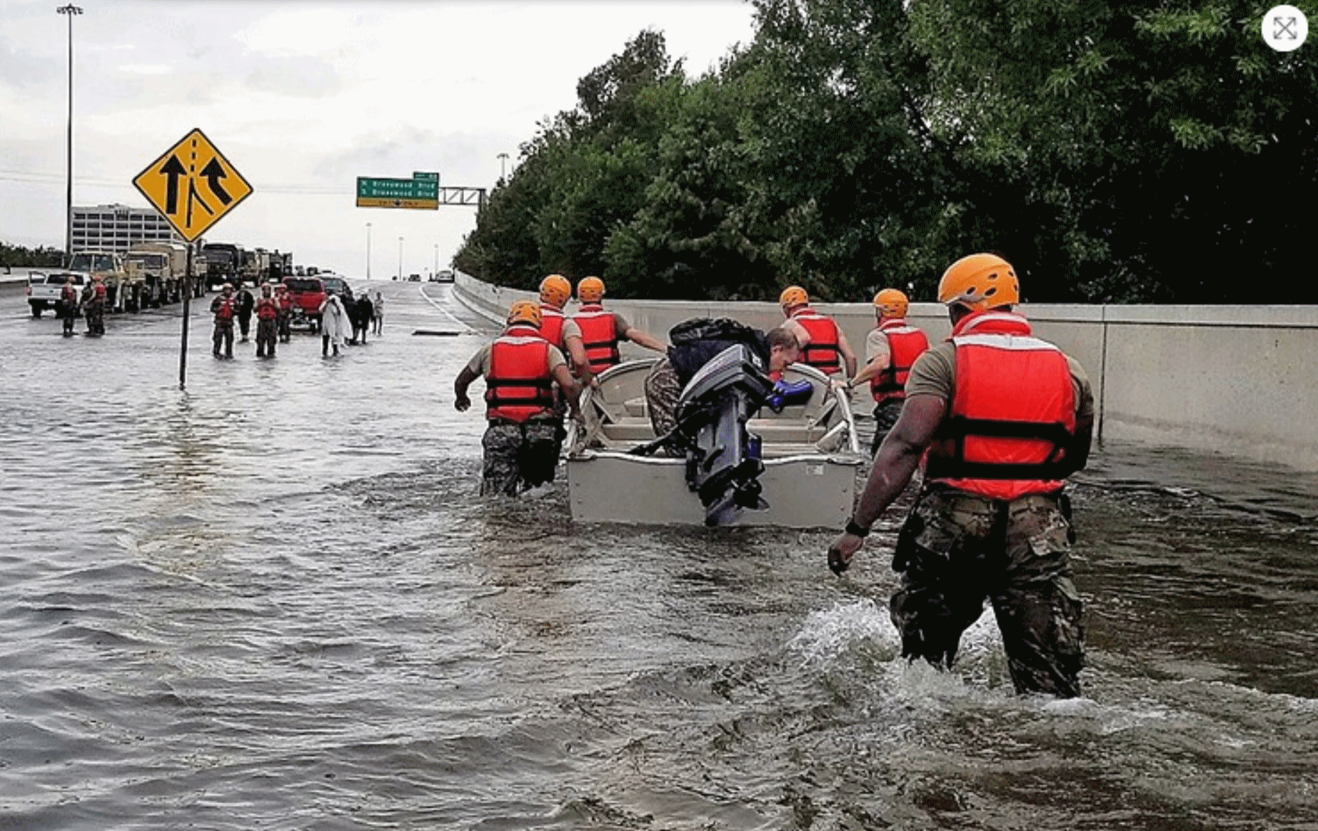
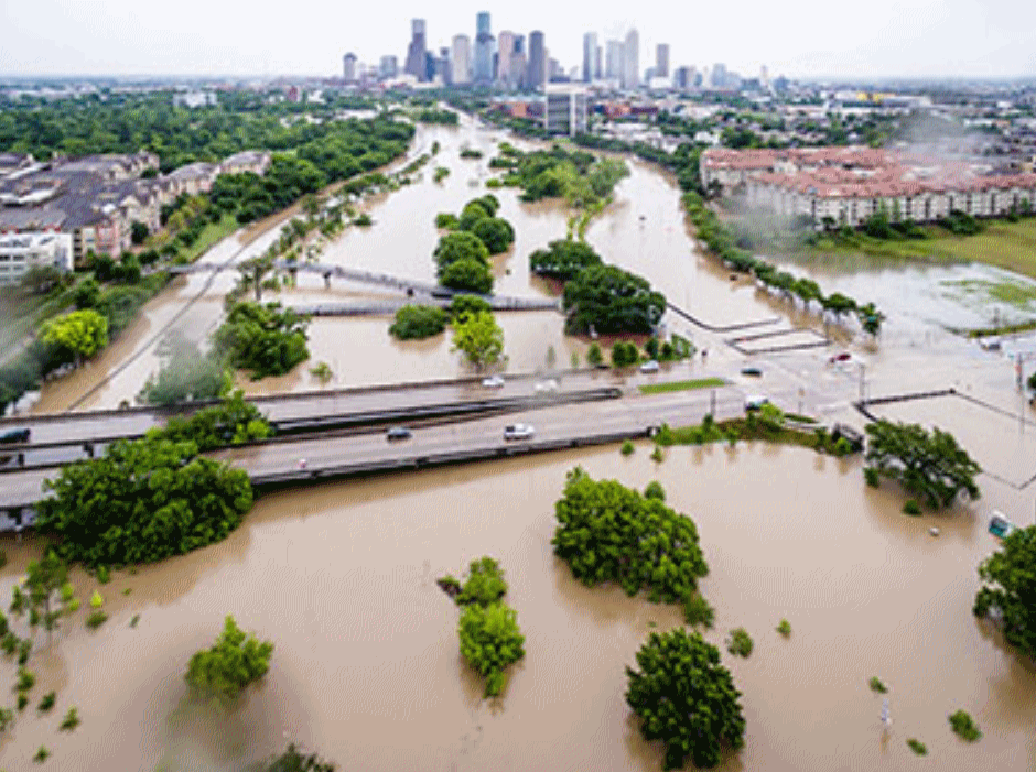
Harvey is Scaring Houston Straight on Flood Safety, But Dallas May Take Longer. The Dallas Observer has some interesting perspective on flood risk in Dallas: “…We have the same system, only more dangerous. If only one of our immense regional reservoirs fails, the toll in human lives would be staggering. As a special project in The Dallas Morning News by George Getschow revealed two years ago, a failure of the aged and decaying Lake Lewisville Dam would put 431,000 lives in immediate jeopardy. An upstream dam failure at any of the three major reservoirs that flow directly into downtown Dallas must be stacked against the old and rickety system of flood safety levees along the Trinity River through downtown. In 2009, the Corps of Engineers rated that entire levee system as “unacceptable,” the most stupidly abused term in contemporary public double-speak. What they really meant was, “no good,” “unsafe,” “won’t do the job,” “grab your water-wings and paddle as fast as you can…”
Photo credit: “Harvey taught Houston that the things it had been told before about flood safety simply were not true.” U.S. Army photo by 1st Lt. Zachary West.
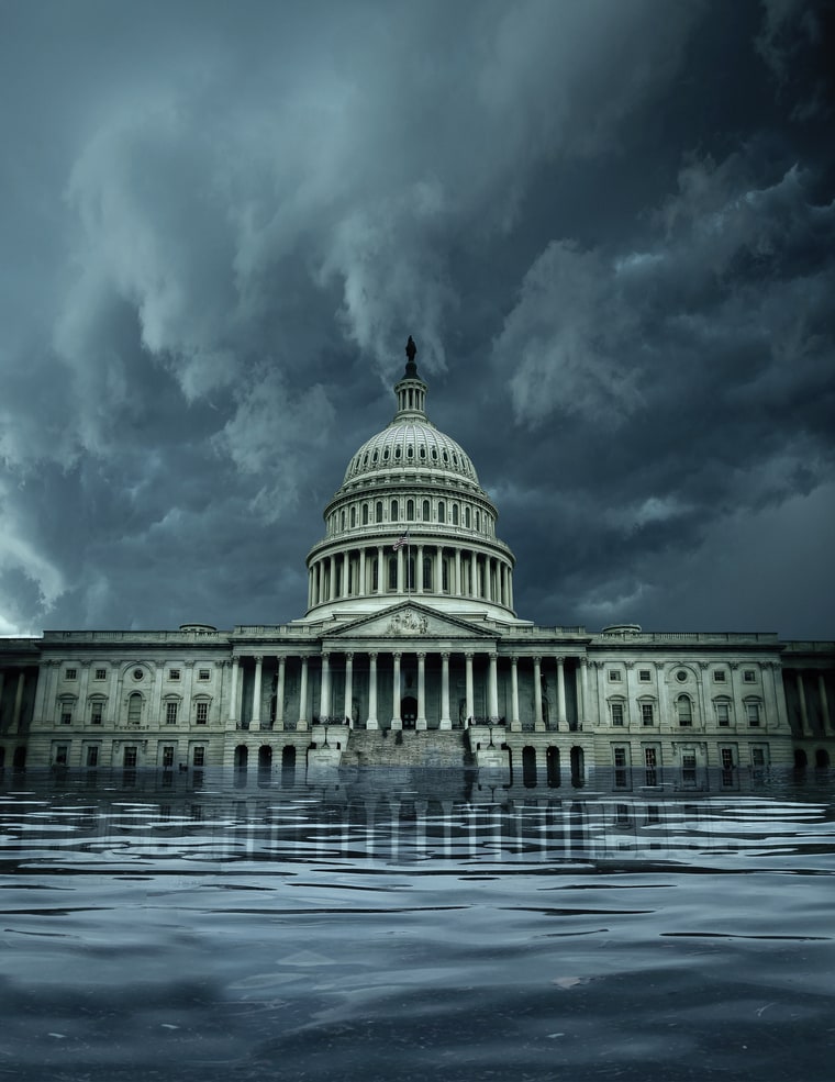
What Happens When a Superstorm Hits D.C.? Rolling Stone takes a look at a worst-case scenario for Washington D.C.: “…For scientists like Resio, a big concern is if a storm system in the mountains unfolds just before a major hurricane hits near the Outer Banks of North Carolina, then tracks inland, pulling a small mountain of water up the Chesapeake, then up the Potomac. This happened in the Chesapeake-Potomac Hurricane of 1933, which carried a deadly 11-foot storm surge; with Hurricane Hazel in 1954; Hurricane Connie in 1955; and Hurricane Isabel, a Category 2 storm that hit in 2003 with a nearly nine-foot surge that severed power at two of Maryland’s largest sewage treatment plants, sending 96 million gallons of sewage flowing toward D.C. “Isabel is a reminder,” wrote David L. Johnson, then assistant administrator for Weather Services, in a government assessment of the storm, “that if the impact of a Category 2 hurricane can be so extensive, then the impact of a major hurricane (Category 3 or higher) could be devastating...”
Illustration credit: John Blackford for Rolling Stone. Photograph used in illustration by Ryan D. Budhu.

What Would An Entirely Flood-Proof City Look Like? The Guardian imagines how cities may be forced to reinvent themselves in the years ahead: “They call it “pave, pipe, and pump”: the mentality that has dominated urban development for over a century. Along with the explosion of the motorcar in the early 20th century came paved surfaces. Rainwater – instead of being sucked up by plants, evaporating, or filtering through the ground back to rivers and lakes – was suddenly forced to slide over pavements and roads into drains, pipes and sewers. Their maximum capacities are based on scenarios such as 10-year storms. And once they clog, the water – with nowhere else to go – simply rises. The reality of climate change and more frequent and intense downpours has exposed the hubris of this approach. As the recent floods from Bangladesh to Texas show, it’s not just the unprecedented magnitude of storms that can cause disaster: it’s urbanisation…”
File photo credit: Jordan Anderson, DoubleHorn Photography.
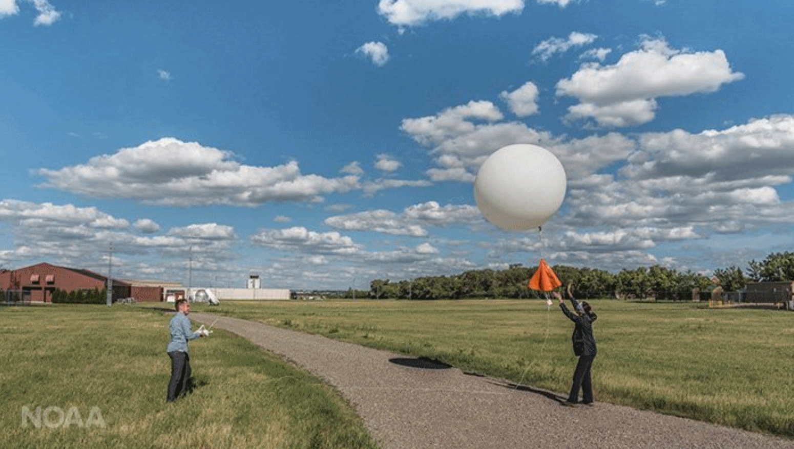
Upper Air Observations: How Weather Balloons Improve Forecasts. Satellites derive wind, moisture and temperature – with weather balloons you get real measurements of the atmosphere in real-time. NOAA explains: “…The radiosondes allow the direct measurement of the upper atmosphere as opposed to the indirect remote sensing techniques employed by satellites or ground-based remote sensing instrumentation. As a result, these observational data are more accurate and reliable than indirect data types. The combination of the two allows for the best forecasts, ensuring public safety in the event of an approaching storm. “Models initialized with good data can provide better and more certain forecast information,” said Aberson. “When the forecast is difficult or different models disagree, more frequent radiosonde observations are requested. This is likely to improve how accurate the forecasts are.”

No, We Cannot Shoot Down North Korea’s Missiles. In case you were wondering, Defense One has a sobering evaluation: “…But could we intercept before the missile climbed that high? There is almost no chance of hitting a North Korean missile on its way up unless an Aegis ship was deployed very close to the launch point, perhaps in North Korean waters. Even then, it would have to chase the missile, a race it is unlikely to win. In the only one or two minutes of warning time any system would have, the probability of a successful engagement drops close to zero. “When over Japan, they are too high to reach,” tweeted astronomer Jonathan McDowell, in between tracking the end of the Cassini mission. “You’d have to put the Aegis right off NK coast to have a chance. “It’s actually virtually impossible to shoot down a missile on the way up,” adds Gerry Doyle, deputy business editor for Asia at The New York Times. “Midcourse or terminal are the only places you have a shot...”

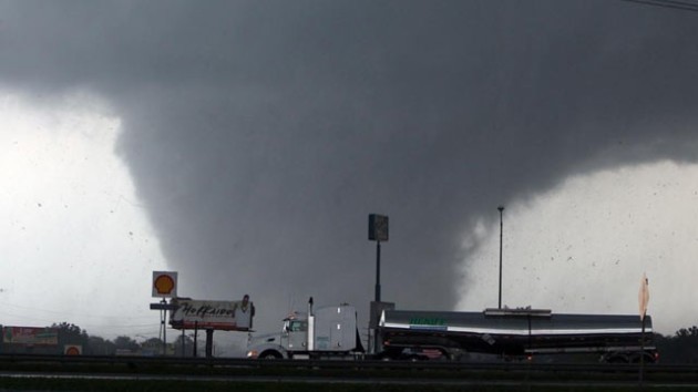
![]() Oklahoma City was rated the riskiest city in the country for natural disasters because of its tornadoes and a recent spate of earthquakes that scientists have linked to the local oil industry. Next on the danger list was a shocker: Silicon Valley’s San Jose, perennially one of the nation’s hottest and priciest real estate markets. Rounding out the top five were Los Angeles and Bakersfield, in California, and then Seattle.
Oklahoma City was rated the riskiest city in the country for natural disasters because of its tornadoes and a recent spate of earthquakes that scientists have linked to the local oil industry. Next on the danger list was a shocker: Silicon Valley’s San Jose, perennially one of the nation’s hottest and priciest real estate markets. Rounding out the top five were Los Angeles and Bakersfield, in California, and then Seattle.


TODAY: Comfortable sunshine. Winds: NW 7-12. High: 65
WEDNESDAY NIGHT: Mostly clear, patches of fog. Low: 51
THURSDAY: Mild sun, stray late-day T-shower possible. Winds: W 5-10. High: 70
FRIDAY: Plenty of blue sky, few complaints. Winds: NE 5-10. Wake-up: 49. High: 67
SATURDAY: Intervals of sun, nicer day of weekend. Winds: SE 5-10. Wake-up: 47. High: 69
SUNDAY: Showers likely, possible T-showers. Winds: S 10-15. Wake-up: 55. High: 63
MONDAY: Showers taper, PM clearing. Winds: W 7-12. Wake-up: 53. High: near 70
TUESDAY: Partly sunny, summer in October. Winds: S 10-15. Wake-up: 56. High: 82
The Best US Cities to Avoid Effects of Climate Change, According to Report. Austin’s Statesman has the story; here are a couple of excerpts: “…According to the report, the Pacific Northwest is the best U.S. region to live to escape the negative effects of climate change, according to Shandas, who said that “their infrastructure tends to be newer and more resilient to major shocks” like heat and rising water. Austin, Texas, about 160 miles from Houston, which was hit hard by Hurricane Harvey, is also among the top 13 cities — in part because of durable infrastructure as well as plans to combat carbon dioxide levels and offset emissions. Here’s the full list in no particular order:
- Seattle, Washington
- Philadelphia, Pennsylvania
- Austin, Texas
- Phoenix, Arizona
- Baltimore, Maryland
- Portland, Oregon
- San Francisco, California
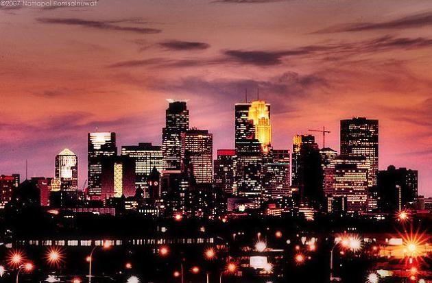
- Minneapolis, Minnesota
- Ann Arbor, Michigan
- Madison, Wisconsin
- Chicago, Illinois...”

Birding: To Cope with Climate Change, Birds Need More Time. A story at Cape Cod Times caught my eye: “…As Dr. Charles “Stormy Mayo, senior scientist at the Center for Coastal Studies in Provincetown, announced in a radio interview in August, “Changes in weather occurred over millennia, thousands of years — birds, mammals, plants and insects could evolve and deal with this slow environmental change — but climate change today happens faster, in some cases less than 10 years.” Bird behavior and bird environment are becoming mismatched: much of a bird’s life cycle and behavior is closely linked to changing seasons. A mismatch occurs when birds cannot shift their behavior in time to coincide with changes in environment, when food is most available for young and adults. Bird behavior is activated by photoperiodism; plants and insects respond to temperatures. One large-scale study has showed that most birds are laying eggs at an average rate of almost seven days earlier compared to 10 years ago...”


Millenials Think About Climate Change Differently Than Anyone Else. Because deep down they realize they are the generation that will be cleaning up our messes; here’s a clip from mindbodygreen.com: “…Millennials are fervent believers that climate change is an issue that needs to be dealt with, and 82 percent of them are concerned about how it will influence their children’s quality of life. But for many, this concern seems to have morphed into a slight helplessness. Nowadays, millennials are doubting their ability to make a dent in such a huge issue and are instead choosing to support companies that have a larger perceived impact. Therefore, they seek out companies that value environmental stewardship and employee treatment practices, even going so far as to prioritize these values above their product’s efficiency. According to data, young people are skeptical of many large corporations, but once they find one they trust, they put a lot of faith into it. Some of their top picks for eco-minded companies include Patagonia, Whole Foods, Tesla, and The Honest Company…”
Photo credit: Saptak Ganguly.