87 F. high in the Twin Cities Monday.
84 F. average high on July 7.
91 F. high on July 7, 2013.
.37″ rain fell yesterday at MSP International Airport.
July 7, 1974: Heat wave with the Twin Cities reaching 101, warmest in 26 years. 2002 three-day deluge ends in central Minnesota with 10 inches in northern Kanabec county and 9.5 inches in southwest Aitkin County.
Atmospheric Lag
June 21 is the Summer Solstice, when the sun is highest in the sky – the best day of the year to catch a debilitating sunburn. Yet the hottest weather of summer normally comes 2-3 weeks later. Why the lag? Just like a pot water on a hot stove takes a few minutes to come to a boil, so it is with our climate system. Land warms faster than water, which means Minnesota’s hottest weather arrives in mid July most years.
We’ve seen glimpses, snapshots of heat, but no long-lasting heat waves to speak of, which is just fine with most folks.
Just when I thought 2014 couldn’t get any goofier, the models I’m staring at next for early next week look like late September or early October. No, we shouldn’t be tracking Alberta Clippers and families of Canadian cool fronts during prime time summertime.
Whether its a symptom of El Nino or evidence of a confused (or “drunk”) jet stream buckling unusually far south for July, expect a cool bias into mid-month.
Clouds linger today; dew points dropping into the 40s Wednesday will leave us all breathing easier. T-storms Friday give way to comfortable sunshine Saturday; highs in the 80s. A more vigorous, almost autumn-like airmass arrives early next week, sparking T-storms Sunday afternoon and a whisper of wind chill by Monday morning, a day we should be experiencing some of the hottest weather of the year.
Sweatshirt weather on July 14.
Huh?
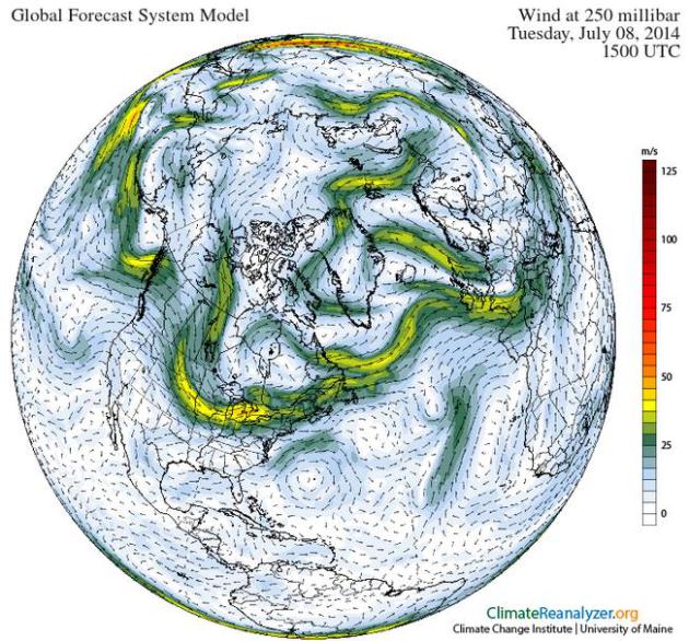
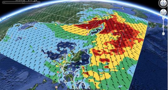
* 250 mb winds at 10 AM today courtesy of Climate Reanalyzer.
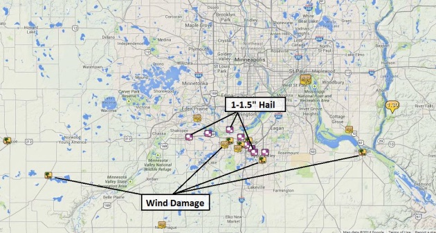
Monday Severe Storm Reports. 1 to 1.5″ diameter hail was reported over the south metro yesterday from Shakopee to Burnsville and Bloomington; wind gusts as high as 50-60 mph reported from Cologne to Hastings. 1.3″ of rain was reported near River Falls, Wisconsin. NOAA has a complete rundown on severe storm reports here. The local MPX Weather Service office has an interactive map.
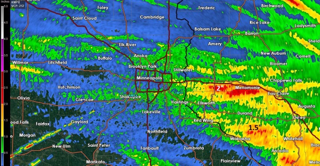
Monday Doppler Radar Rainfall Estimates. Twin Cities NWS Doppler based in Chanhassen estimated some 2″ amounts yesterday near Menomonie; some 1″ amounts near Bloomington from the fast-moving squall line.
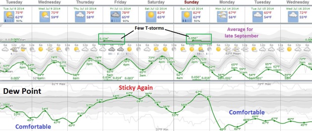
More Unusual Swings. After cooling off by midweek with dew points dropping into the upper 40s and low 50s we warm up again by the weekend (low to mid 80s possible both days). This next push of warmer air sparks a few showers and T-storms Thursday night into Friday. Saturday appears to be the nicer, drier day of the weekend. The approach of an airmass that would be right at home on September 30 sparks T-storms during the PM hours Sunday; by Monday and Tuesday temperatures may not climb out of the 60s. Unusual, considering early and mid July usually brings the hottest weather of the year. Source: Weatherspark.
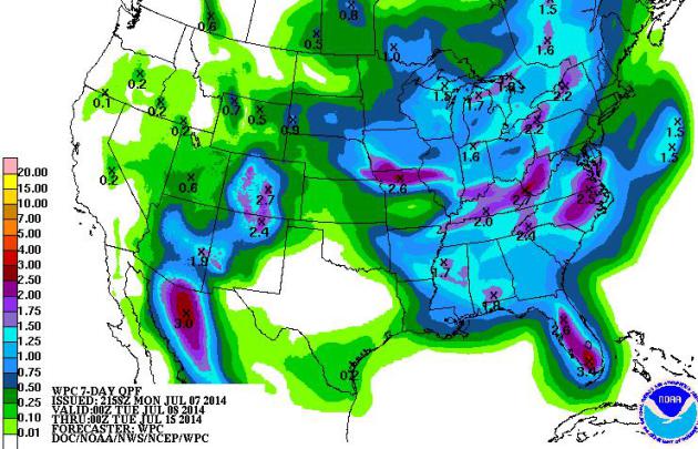
7-Day Rainfall. Heaviest rains fall from the Midwest into the Ohio Valley and Carolinas thru Tuesday of next week; some 2-4″ amounts in downpours over Florida. Monsoon T-storms drop some badly needed rain from Arizona into Colorado. Source: NOAA.
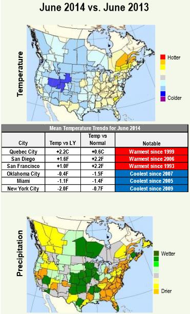
June 2014 vs. June 2013. Cooler over roughly the western half of the USA; much wetter over the central USA, but dry in California and much of the east. Here’s an excerpt of an interesting analysis from the experts at Planalytics, a few bullet points from last month. The full report summary (PDF) can be found here.
- Cool and Dry Holiday Periods Supported Outdoor Activities and Related Categories.
- Father’s Day in the U.S. was the coolest since 2004 and the driest since 2005.
- July 4th was the coolest since 1997 with rainfall focused in the Great Lakes and Northeast.
- Severe Weather Increased, Including the First Hurricane of the Atlantic Season.
Over 5,700 severe weather events occurred, a notable increase compared to recent months…”

Super Typhoon Heading for Japan is a “Once in a Decade” Storm, Says Forecasters. Neoguri may be the most intense typhoon (same thing as hurricane) to impact Japan during the month of July. Here’s an excerpt from a story about “Neoguri” from The South China Morning Post: “Japan’s weather forecasters today described Super Typhoon Neoguri, which is barrelling towards the country, as a ‘once in decades storm’. With winds already at a sustained 180km/h and gusting up to 250km/h, the typhoon is expected to gain power before it hits the southern Okinawa island chain before making landfull on the country’s westernmost island of Kyushu – home to two nuclear plants. Japan’s Meteorological Agency predicted it would grow into an “extremely intense” storm by Tuesday...”
Photo credit above: “A view of Super Typhoon Neoguri captured from the International Space Station.” Photo: Reid Wiseman/Twitter.

A Scary Super Typhoon Is Bearing Down on Japan, and It’s Nuclear Plants. Neoguri may still hit as a Category 1-2 strength typhoon, capable of significant storm surge damage. In light of the tragedy of Fukushima Chris Mooney at Mother Jones examines the safety of two plants in its potential path; here’s an excerpt: “…According to reporting by Reuters, there are two nuclear plants on the island. A company spokeswoman for Kyushu Electric Power Co. told the news agency that it “has plans in place throughout the year to protect the plants from severe weather.” Will that be good enough? According to Edwin Lyman, senior scientist in the global security program at the Union of Concerned Scientists, the good news overall is that Japan’s nuclear plants are currently shut down, awaiting permission to restart as they institute stronger safety protections, including the construction of higher seawalls. A shut-down plant is still not without risks, because “you still have to provide cooling for the fuel,” says Lyman…”
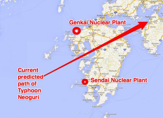
Understandable Paranoia. Science writer Greg Laden has more details on the two Japanese reactors in the potential path of Super Typhoon Neoguri at scienceblogs.com.
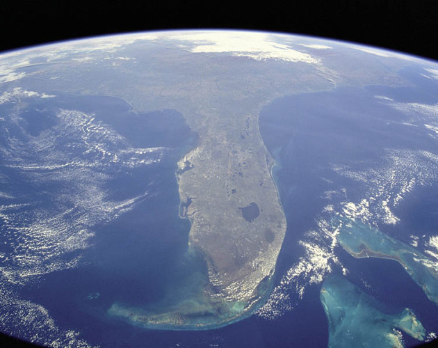
Warm Waters Around Florida Inviting to Hurricanes. The warmer (and deeper) the water, the greater the potential for hurricane intensification, all other things being equal. Here’s a clip from a story at The St. Augustine Record: “…In August, the surface waters around Florida, from the Gulf of Mexico to the Straits of Florida to the close-in waters of the Atlantic Ocean, average a nice, warm, inviting 84 degrees Fahrenheit. Tropical storms need to feed on surface water that’s about 78 degrees. If deep water is cooler, as the storm brings it to the surface, the hurricane’s not getting enough hot water — high octane fuel — and it weakens…” (Image credit: NASA).
How IBM Is Using Big Data To Fix Beijing’s Pollution Crisis. Quartz has a fascinating article about how China is trying to use Big Blue’s ultra-high-resolution computer modeling to track down the source of some of the worst pollution; here’s a clip: “…IBM plans to improve the quality of data by installing its latest generation of optical sensors, incorporating meteorological satellite data and running that through its artificial-intelligence computing system (a.k.a. Watson, that computer that trounced humans on Jeopardy). The visual maps it generates will identify the source and dispersal pattern of pollutants across Beijing with a street-level degree of detail 72 hours in advance...”
Image credit above: “An IBM interactive visualization showing evolving temperature and wind directions over China.” Courtesy of IBM.

The First Conscious Machines Will Probably Be On Wall Street. When in doubt follow the money. Here’s an excerpt of a fascinating, if not altogether reassuring, story from The Mitrailleuse: “…Even today we see supercomputers owned by financial institutions, making trading decisions on behalf of the companies that own them. These are specialized machines that do something that produces similar results to cognition. The fact that they are specialized thinking machines might lead one to believe that this precludes them from consciousness. I think the opposite is true; human beings are not generalized computing organisms. Humans, just like the machines in question, are not general purpose beings, but highly selective imitation devices with an innate dedicated language system…”

Barry Gibb: The Last Brother. Here is a sad and poignant story about Barry Gibb, the last remaining member of the Bee Gees, an excerpt from an in-depth interview at RollingStone.com: “…They’re the only group in history to have written, recorded and produced six consecutive Number One hits. “We weren’t on the charts,” Maurice once boasted, “we were the charts.” And then, just like that, they weren’t. America decided that disco sucked, and the Gibb brothers went from icons to punch lines overnight. Andy passed away, then Maurice. Now that Robin was gone, Barry was the only one left…”
Photo credit: Peter Yang.

Fireworks Filmed With a Drone. Check out this amazing HD YouTube clip captured by Jos Stiglingh for a vantagepoint you could only get with a drone: “Flying through a firework show with a DJI Phantom 2 and filming it with a GoPro Hero 3 silver. The quad was not damaged.”
WXYZ Chief Meteorologist Seriously Injured in Fireworks Accident. Our prayers are with Dave and his family in the Detroit area; details from TVSpy: “Dave Rexroth, thechief meteorologist at Detroit ABC affiliate WXYZ, was seriously injured in a fireworks accident over 4th of July weekend. The station reports the accident caused Rexroth to lose sight in his left eye:
He is currently hospitalized in Iowa City and is scheduled to undergo surgery on Wednesday. That will begin the process of Dave receiving a prosthetic eye. He expects to fully recover by September…”

Is A Wedding Day Tornado Good Luck? Because nothing says I love you better than holding hands in front of an EF-2 tornado. Here’s more from NBC’s Today Show: “…A Canadian couple caught in front of a tornado while posing for their wedding photos stayed calm in the face of the storm, leading to a series of stunning images. Photographer Colleen Niska captured breathtaking photos of the happy couple in the province of Saskatchewn, all while a tornado appears to be just up the road…”
Photo credit above: Colleen Niska.
TODAY: Mostly cloudy, cooler breeze. Winds: NW 10-20. High: 75
TUESDAY NIGHT: Clearing, cool for early July. Low: 58
WEDNESDAY: Partly sunny, low humidity. Dew point: 49. High: 76
THURSDAY: Fading sun, still pleasant. Wake-up: 57. High: 79
FRIDAY: Unsettled, a few showers and T-storms are likely. Wake-up: 65. High: 78
SATURDAY: Partly sunny, nicer day of the weekend. Wake-up: 65. High: 83
SUNDAY: Sunny start, PM showers and T-storms. Wake-up: 63. High: 81
MONDAY: Mostly cloudy. What happened to July? Wake-up: 55. High: 68 (!)
Climate Stories…


U.S. House Candidate Makes Climate Action a Campaign Centerpiece. Registered voters are 2.5 times more likely to vote for a congressional or presidential candidate who supports action to reduce global warming. Further, registered voters are 3 times more likely to vote against a candidate who opposes action to reduce global warming? That’s an excerpt of a story by Peter Sinclair at Climate Denial Crock of the Week: “Michigan House District 11 Candidate Nancy Skinner is making climate change a centerpiece of her campaign, going into next month’s primary, and has come out swinging with the piece you see above. Last week I posted a bit of distilled climate paranoia, in a video from a Louisiana congressional primary, where Sara Pailin clone Lenar Whitney laid out the complete conspiracist’s looniest fantasy of climate science as a global plot. The piece has appeared in a lot of places, and I think its an example of looney climate denial having jumped the shark in the American mind…”

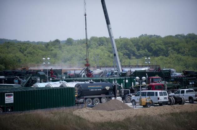
Rolling Coal. Yes, for a mere $500 you can trick your truck into burning more gas and putting out more black exhaust, annoying any Prius owners in your midst. Because there’s nothing funnier than being smelly, dirty and wasteful. Here’s a clip from Slate: “Prius Repellent” is a perfect introduction to one of the Obama era’s great conservative subcultures: the men and women who “roll coal.” For as little as $500, anyone with a diesel truck and a dream can install a smoke stack and the equipment that lets a driver “trick the engine” into needing more fuel. The result is a burst of black smoke that doubles as a political or cultural statement—a protest against the EPA, a ritual shaming of hybrid “rice burners,” and a stellar source of truck memes. The “Prius repellent” decal is easy to find on truck fan sites, as are memes of single or double stack trucks humiliating the drivers of smaller cars…”
Photo illustration by Slate, photo courtesy Mark Spearman/Flickr Creative Commons.
