Wet Saturday – And A Wet August – In The Twin Cities
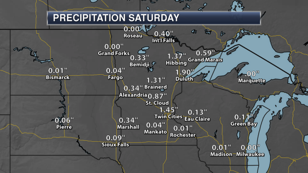
Saturday wasn’t exactly a nice day across most of the state, with many areas seeing at least periods of rain throughout the day. The Twin Cities saw just under an inch and a half of rain Saturday, but record breaking rain fell in Duluth.
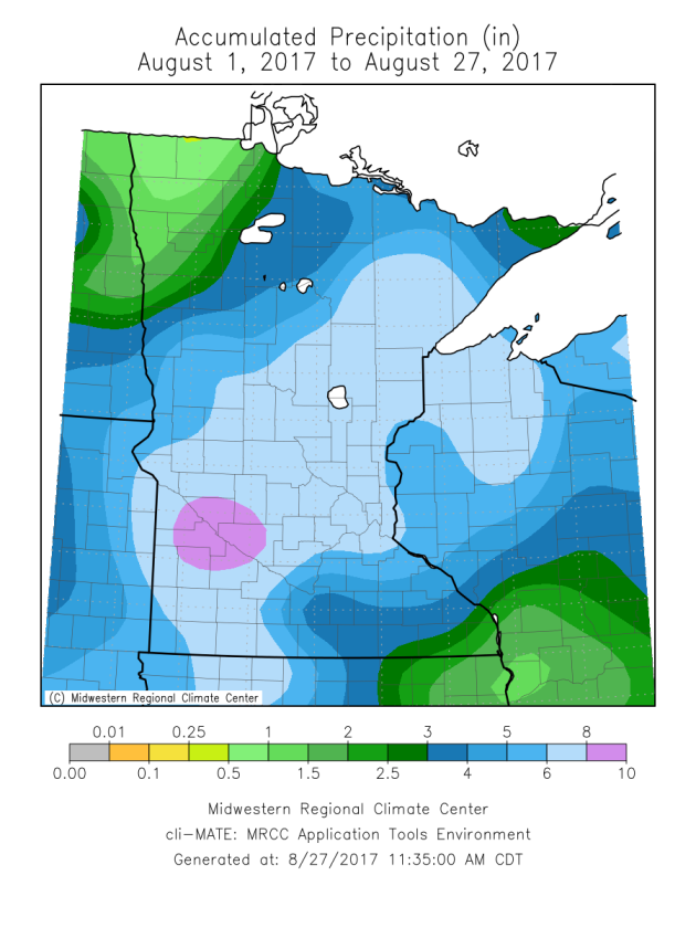
This continues the very wet August we have observed over most of the state. You can see a widespread swath of 5″+ rain from southwest to northeast Minnesota has fallen this month, with rain amounts tapering off on either side of that. Parts of northwest and far southeast Minnesota have seen less than a couple inches of rain, however.
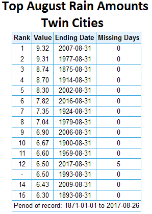
Through Saturday, 6.50″ of rain has fallen this month in the Twin Cities, tying for the 12th wettest August on record so far. Last August was also wet with 7.82″ of rain falling, marking the 6th wettest August on record. It is interesting to note six of the top 15 wettest Augusts have occurred since 2000.
_______________________________________________
New Climate Brings Things We Haven’t Seen Before
By Paul Douglas
In my new book, “Caring for Creation”, I quote my 87-year old father. “There probably has to be some natural catastrophe that can clearly be blamed on climate change. We always need something big to shock us, to wake us up. Think Pearl Harbor or 9-11.”
Climate change didn’t trigger Hurricane Harvey, but there’s a good chance a warmer, wetter climate made it much worse. Rainfall amounts of 30-55 inches from a single storm? A hurricane that stalls and lingers for an entire week? Is it natural variability – or have we loaded the dice? Warmer air holds more water vapor; more fuel for floods.
It’s not just Houston. The frequency and intensity of extreme flooding is increasing, worldwide. Houston is a worst-case scenario. The rain won’t stop until Friday – the city may take years to return to normal.
A thundershower may sprout here late Wednesday, otherwise a dry, lukewarm week is on tap. After a cool, wet August this comes as very good news. Next weekend looks lake-worthy with 80s & sunscreen. A cool front arrives on Labor Day, but let’s not complain about the weather anytime soon.
_______________________________________________
Extended Twin Cities Forecast
MONDAY: More clouds than sun. High 73. Low 58. Chance of rain 20%. Wind N 7-12 mph.
TUESDAY: Partly sunny and pleasant. High 78. Low 61. Chance of rain 10%. Wind E 3-8 mph.
WEDNESDAY: Some sun, late-day pop up T-shower? High 81. Low 59. Chance of rain 30%. Wind W 5-10 mph.
THURSDAY: Mix of clouds and sun, pleasant. High 77. Low 58. Chance of rain 20%. Wind E 5-10 mph.
FRIDAY: Lukewarm sunshine on tap. High 78. Low 64. Chance of rain 20%. Wind S 7-12 mph.
SATURDAY: Partly sunny, evacuate to the lake. High 83. Low 63. Chance of rain 20%. Wind NW 5-10 mph.
SUNDAY: Warm sun, T-storms up north. High 86. Low 56. Chance of rain 40%. Wind W 10-15 mph.
_______________________________________________
This Day in Weather History
August 28th
1989: Baseball-sized hail pummels Pequot Lakes.
_______________________________________________
Average Temperatures & Precipitation for Minneapolis
August 28th
Average High: 78F (Record: 94F set in 1955)
Average Low: 60F (Record: 42F set in 1934)
Average Precipitation: 0.12″ (Record: 1.11″ set in 1950)
________________________________________________
Sunrise/Sunset Times for Minneapolis
August 28th
Sunrise: 6:30 AM
Sunset: 7:56 PM
*Length Of Day: 13 hours, 26 minutes and 2 seconds
*Daylight Lost Since Yesterday: ~2 minute and 58 seconds
*Next Sunrise At/After 6:30 AM: August 28th (6:30 AM)
*Next Sunset At/Before 7:30 PM: September 11th (7:30 PM)
_______________________________________________
Minnesota Weather Outlook
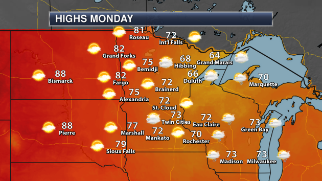
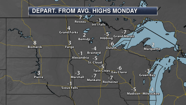
Another cool-ish day is expected in the Twin Cities Monday, with a mix of clouds and sun and temperatures climbing into the low/mid 70s. Warmer weather will be found across western Minnesota, where some areas could approach 80 (especially around Roseau). Highs will be stuck in the 60s, though, for areas like Hibbing and Grand Marais with cloudier skies.
Highs will be slightly below average for this time of year across a majority of the state Monday, with the warmest spots being across northwest Minnesota.
Over the next few days, we will see highs climb a little bit toward the middle of the week and then again next weekend, but still there are no 90s in sight through the first full week of September.
Most of the week will be dry across the Twin Cities, with our next chance of rain not moving in until late in the week. Another chance of rain will then be possible for the second half of next weekend. Rainfall amounts through next Sunday could top an inch.
_______________________________________________
Harvey Continues To Flood Texas
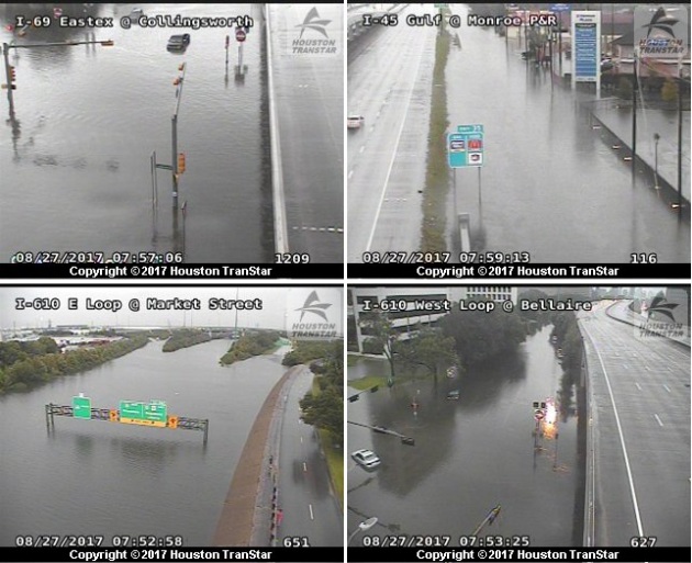
There are numerous scenes of heartache across the Houston metro on Sunday, as epic heavy rains hit the city over the past couple days, causing catastrophic flooding across the metro. Numerous bayous and creeks are historically out of their banks.
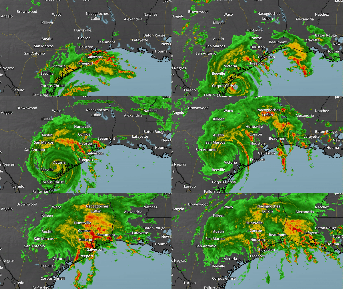
(Hourly radar loop between 7 AM Friday and 1 PM Sunday)
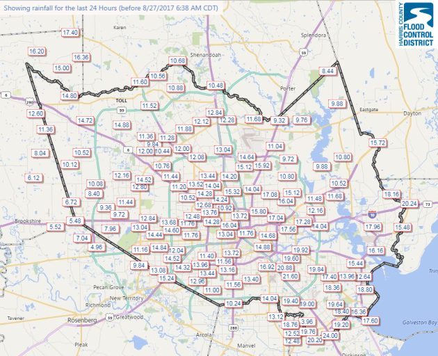
What has happened is that bands of rain from Harvey have kept feeding into the same locations east of the nearly stationary circulation, causing heavy rain to move into the same areas over and over again. Unfortunately, that set up over Houston, with areas seeing two feet of rain within a 24 hour period.
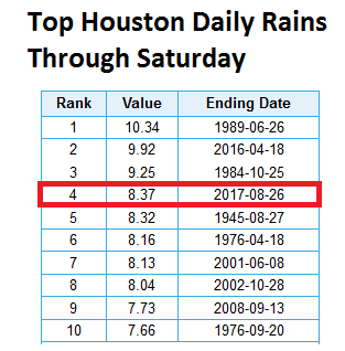
On Saturday, 8.37″ of rain fell at Houston Intercontinental Airport, making it the fourth wettest day in history (technically now the fifth wettest after Sunday). Then, at least 11.82″ of rain fell through 4 PM Sunday, making August 27th the wettest day on record. When you add up day after day of heavy rain (especially hour after hour where rainfall rates are on average between 3-6″ per hour) – you get the situation that the Houston metro is in now.
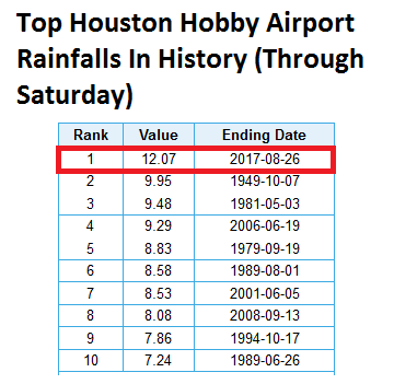
Meanwhile, the rain that Houston-Hobby Airport saw Saturday broke the previous ALL-TIME daily record by more than two inches. Hobby Airport closed early Sunday morning due to water on the runways.
24 hour rain totals through ~6:30 AM Sunday morning across Harris County, including Houston. Credit: Harris County Flood Control District
Of course, this is going to be a massive disaster. Andrew Siffert, a meteorologist for BMS,
wrote a blog post Sunday in which he estimates that the damage costs from Harvey will likely top $10 billion. More: “
It is now easy to understand that Harvey will easily reach well over $10 billion USD in economic loss. The winds and surge losses are still being assessed and given the footprint of affected areas, it is going to take weeks until full assessments are gathered to understand the totality of the damage. However, from what we know now the general consensus seem the wind related losses will likely be in excess of $2 Billion in insured loss with a much higher economic loss. If you combine this with what historical flood events have done just to the Houston area in the past (Allison 2001 $3.4B adjusted – $10B economic) insured losses are likely in excess of $5 billion dollars. In fact, for more perspective the catastrophic flooding that occurred in Louisiana last year (August 11 – 15) caused $1 Billion in insured loss according to PCS. That flooding occurred over an area with about 850K people. Houston has 7 times more population being the fourth largest city in the U.S. and the rainfall totals will be higher than what occurred in Louisiana last year.“
Steve Bowen, a meteorologist at reinsurer Aon Benfield, seems to agree:
Meanwhile, only about 1/6th of the homes in Harris County have flood insurance through the National Flood Insurance Program according to Bryan Wood, a meteorologist and storm damage analyst at Assurant.
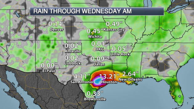
Unfortunately, the rain just continues over the region. As bands from Harvey continue to move across parts of the middle and northern Texas coasts, heavy rain and catastrophic flooding will continue. This shows that an additional 13 inches of rain will be possible for Houston through Wednesday morning, with of course areas seeing heavier totals.
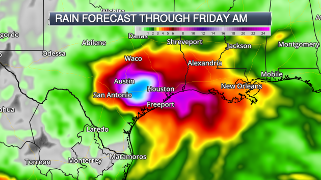
The problem is… the rain just continues, even after the middle of the week. Harvey will be slow to move off, still sitting in the state next Friday. That means that heavy rain will continue… and that some areas will see an additional 15-20″+ of rain on top of what they’ve already received. We could easily see total storm rainfall accumulations of 40-50″+ by the time Harvey finally makes it out of the state.
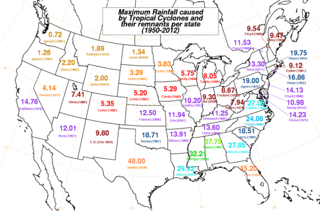
The largest ever tropical cyclone rain in Texas (from 1950 to 2012) was Amelia back in 1978. That system brought 48″ of rain to Medina, TX.
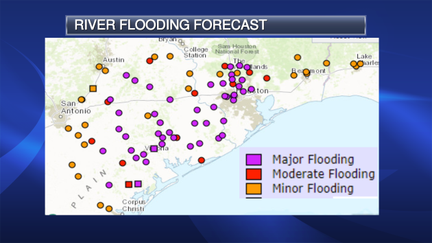
Many bayous and creeks in the Houston area were approaching/breaking record levels throughout the day Sunday. With even more rain expected, we can expected river flooding to go on throughout most of the week. Many rivers in the region could see major (if not record) flooding this week.
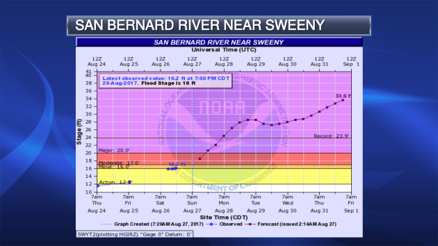
Take a look at this hydrograph for the San Bernard south of the Houston area near Sweeny. The river is expected to reach ten feet above record levels by Friday. Just an example of the historic, catastrophic flooding that will continue for a while across the region.
Eric Berger does have some perspective, though, that must be read over at
Space City Weather: “
The situation seems horrible now, and with the prospect of more rain, you may feel hopeless or helpless, or both. From a mental health standpoint, the uncertainty this brings adds a considerable amount of stress to an already stressful situation. I wish we could tell you when the rains will end, but we can’t. Here’s one thing we are sure of, however. The rains will end. After that the sun will come out.“
_______________________________________________
National Weather Outlook
Monday’s Forecast
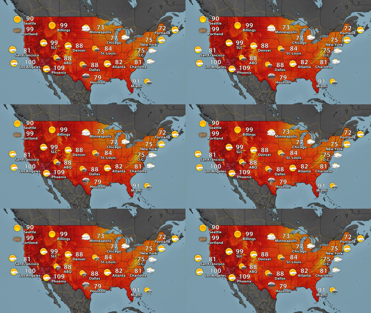
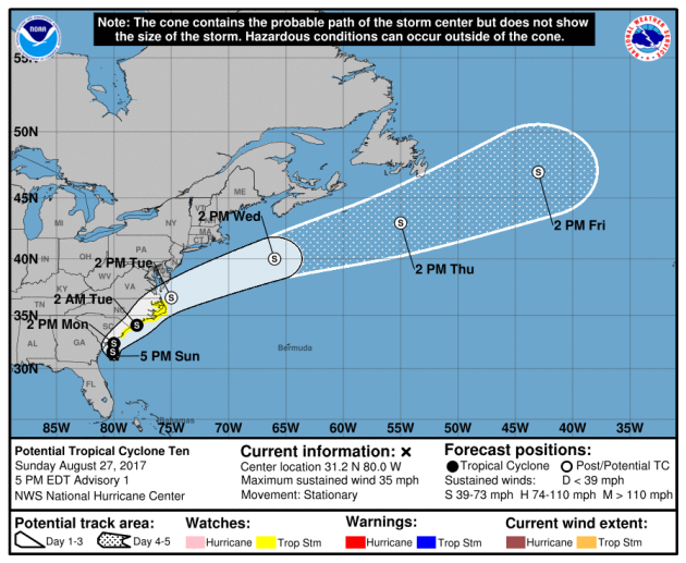
While life-threatening rain and flooding continues across the southern Plains, we do have a few more stories to watch across the county. A few showers to storms will be possible from the Great Lakes to Kansas and Oklahoma as a cold front moves through. We’re also continuing to track a tropical disturbance that has been moving across Florida this weekend. That has become Potential Tropical Cyclone Ten, which will likely become Tropical Storm Irma while impacting parts of the Carolinas and Georgia. Meanwhile, temperatures will be warming up out west, with Los Angeles expected to hit 100.
Tropical Storm Watches are in effect from South Santee River, SC, to Duck, NC, including Albemarle and Pamlico Sounds, as Potential Tropical Cyclone Ten is expected to become Irma. The system will impact these areas over the next couple days before quickly being pushed out into the Atlantic.
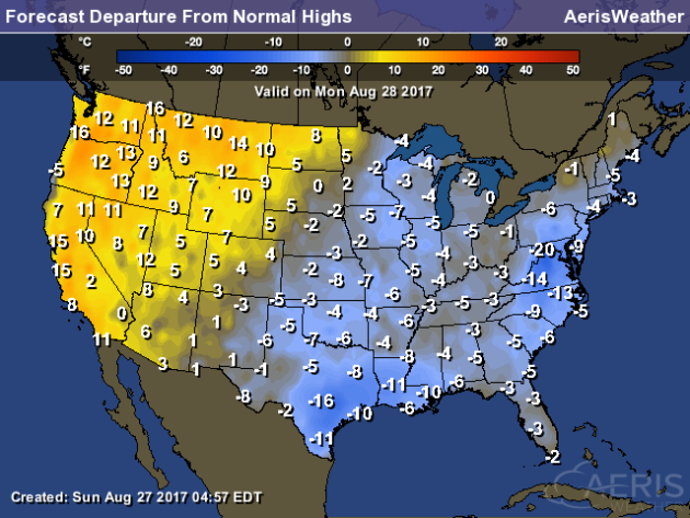
The west will be warm once again Monday, with highs that will be a good 5-15 degrees above average for this time of year. Meanwhile, the coolest weather will be in parts of the south being hit by Harvey as well as in the Mid-Atlantic, where some highs will be a good 10-20 degrees below average.
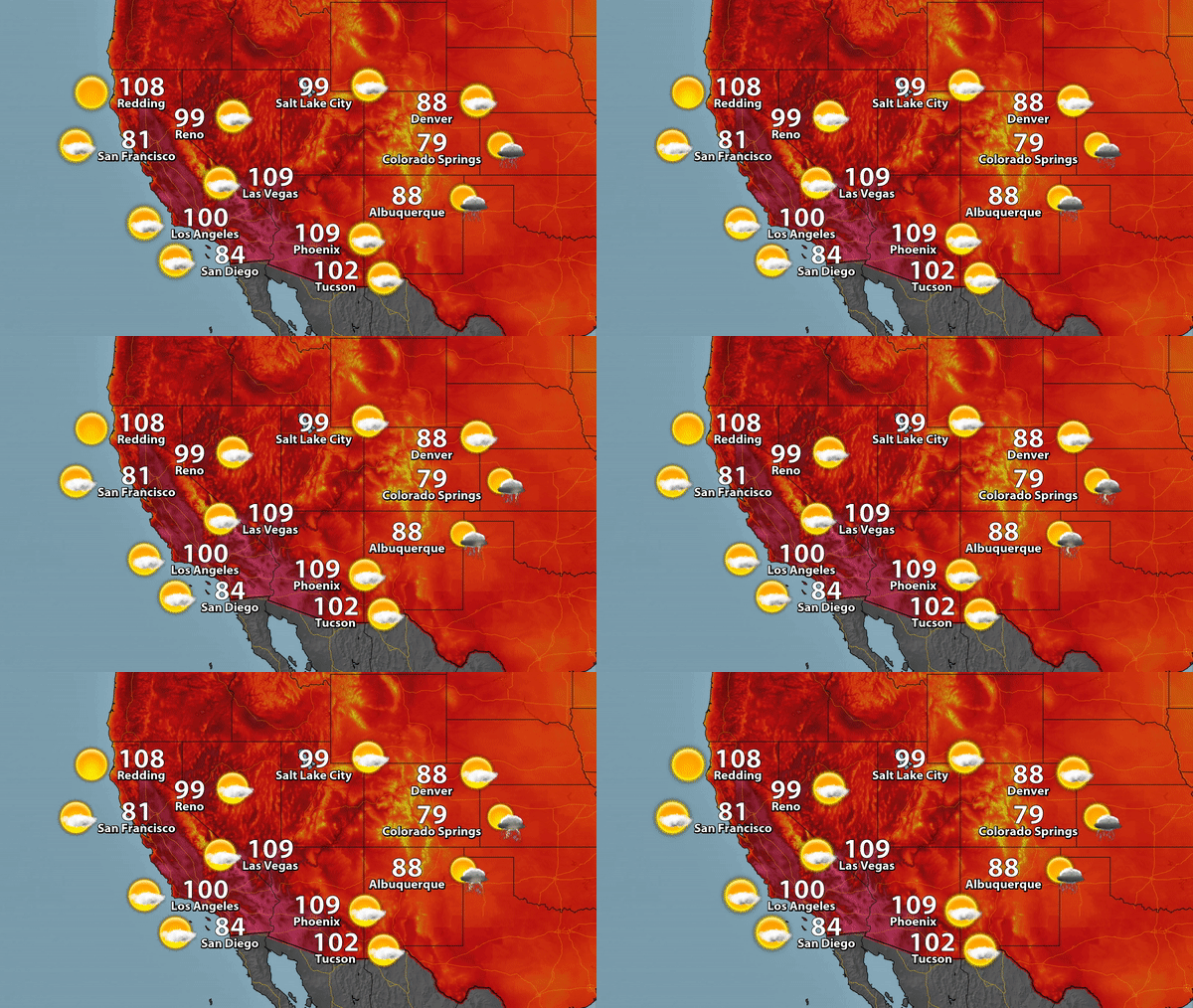
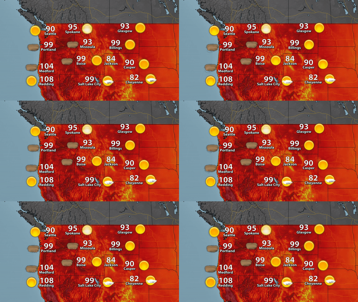
With the heat expected into early in the week in parts of the west, Excessive Heat Warnings and Heat Advisories are in effect, including Los Angeles, Las Vegas and Portland. Highs will climb into the 90s and 100s in spots.
Areas like Los Angeles, Las Vegas, Salt Lake City and Sacramento will approach (if not break) record highs on Monday as highs climb into the upper 90s and 100s.
Highs in Portland will approach 100 on Monday, with record highs possible for areas like Eugene and Medford.
_______________________________________________
Avocado Prices To Spike
Heads up! You might want to buy your avocados now if they are still cheap where you are. Prices are likely to spike soon due to drought and warm weather winter.
More from KGTV-TV: “
The price of avocados could triple in the next few weeks, experts say, as the end of the season supply dwindles. The California Avocado Commission says this year’s crop is almost half of last years, down to an estimated 212.3 million pounds across the state. Last year at this time, they were estimating almost 400 million pounds.“
California To Cut Down Dangerous Trees
Dangerous trees exist in California due to the weather over the past few years. Caltrans has a plan to remove them.
More from the Sacramento Bee: “
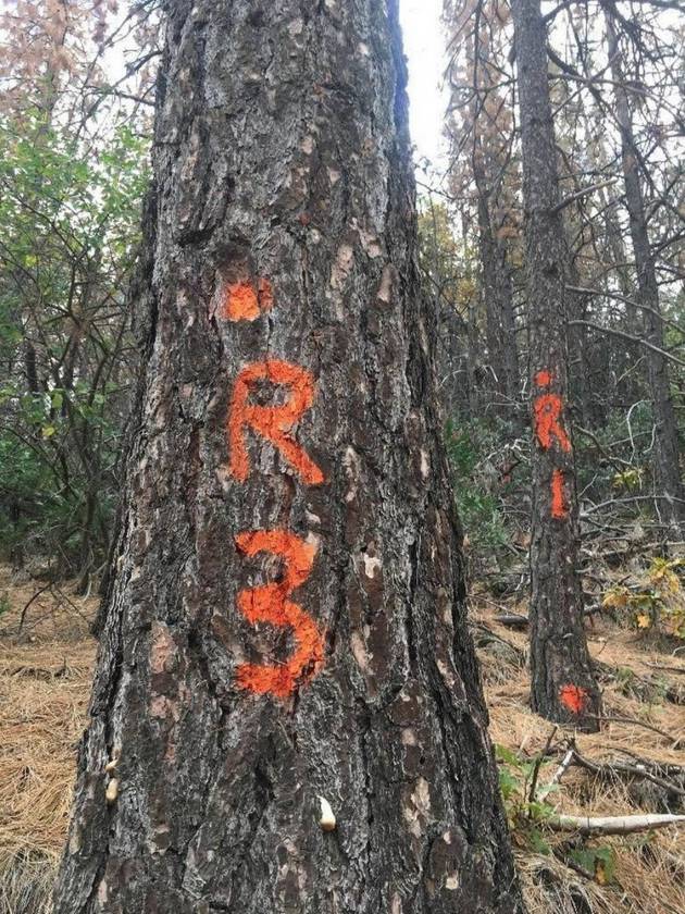
California crews will begin cutting down dead and drought-weakened trees along highways in the Tahoe Basin next month as part of a massive statewide effort to remove dangerous trees before they fall onto highways. Crews will focus on Highway 89, where a tree toppled and killed a Tahoe City woman in her car near Squaw Valley earlier this year during a winter of heavy snowstorms, as well as other mountain highways near the lake.” (Image: The state is marking dead trees near mountain highways for removal as a safety precaution. Caltrans)
Michigan To Shut Down A Coal Plant
A coal plant in Michigan is getting ready to shut down in 2025.
More from the Associated Press: “
The planned retirement of Delta Township’s Erickson Power Plant is part of an agreement between the Lansing Board of Water & Light made and the Sierra Club, an environmental group. The utility also made plans in 2015 to retire the coal-burning Eckert Power Plant in Lansing by 2020, the Lansing State Journal reported . Its website said the two plants create more than 500 megawatts of power combined.“
_______________________________________________
