
A Cold Rain
Ice is coming off Minnesota lakes a couple weeks earlier than 2014. Trees are budding, rhubarb poking up through damp soil – the frost nearly gone now. Yes, we are limping into spring and I am VERY happy to be tracking green blobs on Doppler radar.
The weather this week will help you focus on work and errands; no lukewarm fronts luring you outside anytime soon. Up to 6 inches of snow fell on Pine County yesterday, and models are hinting at a risk of slush in the metro Friday morning, mainly lawns and slow-moving robins.
For the most part the lowest mile of the atmosphere should be mild enough for rain spilling out of a curdling sky; heaviest on Thursday, again Sunday. Many towns will pick up half an inch of rain by next Monday, enough to put a modest dent in our nagging drought.
My gut (nausea?) is telling me that 2015 will be warmer and drier than 2014, based on the way patterns are setting up, and an El Nino warm phase of the Pacific that now looks much stronger than what was predicted months ago.
Before long we may be complaining about heat, whining about the humidity, shaking a fist at a dry, dusty sky.
Forgive me while I enjoy a cold rain and rediscover “green”.
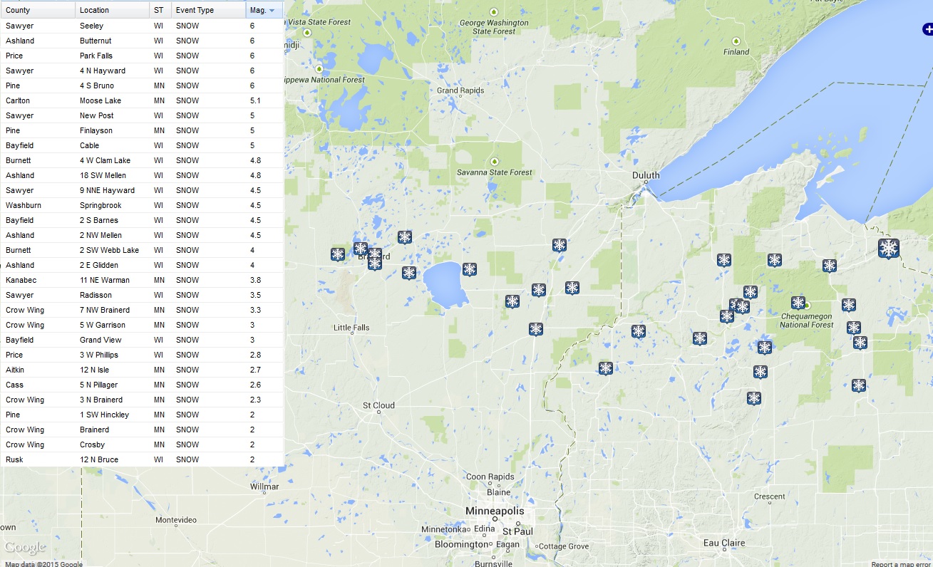
Monday Morning Slush. It was a relatively narrow band of snow, stretching from near Brainerd and Lake Mille Lacs to Pine County, where as much as 6″ of snow piled up, mainly on lawns and fields. About 2″ fell in Brainerd. 4-5 days ago both the ECMWF and GFS hinted at some 6″ amounts by early Monday – I have to say that they were on the right track. Map: National Weather Service.

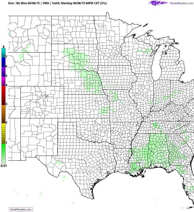
Friday Morning Slop-Snow? My confidence level is lower than usual, but NOAA’s NAM ensembles print out a little slush east of the Twin Cities Thursday night and Friday as the entire atmosphere cools behind a slow-moving storm. If this solution verifies an inch or two of slush could accumulated from near Spooner to Baldwin, Red Wing and Rochester. Source: HAMweather.
On The Northern Fringe of Significant Moisture. The Twin Cities could still wind up with half an inch or more of water by Monday of next week; NOAA NAM guidance into early Friday shows some 1″+ rainfall amounts over far southeastern Minnesota, closer to 3″ possible near Madison and Rockford.
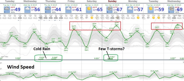
Spring Fever Returns This Weekend. The next few days will be raw, especially Thursday, when the heaviest rain may fall, keeping temperatures in the low to mid 40s. But the sun peeks out Friday afternoon with a growing chance of 60s returning over the weekend; European guidance hinting at potentially heavy T-storms Sunday PM hours.
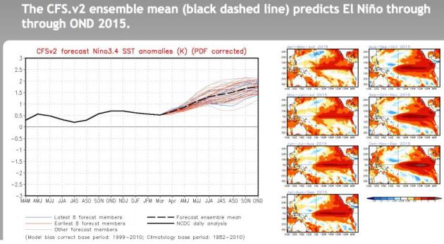
A Super-Sized El Nino in 2015 After All? Our on-again, off-again El Nino warming of Pacific Ocean water is very much on again as temperature anomalies continue to rise in the central and eastern Pacific. NOAA CPC is predicting overall temperature anomalies of 1.5 to 2C warmer than average by fall and winter, which would tend to imply a milder (drier) winter for Minnesota and the Upper Midwest. In theory. On paper. Your results may vary.
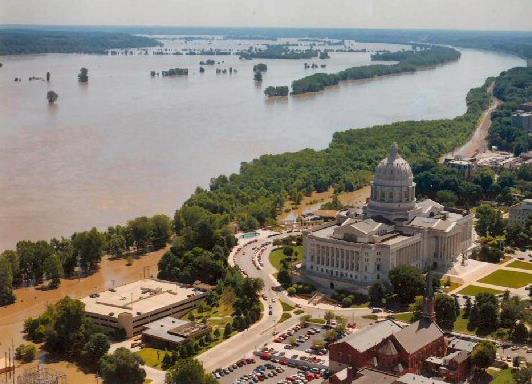
Remembering The Great Midwest Flood of 1993. I have vivid memories sandbagging the Racoon River in Des Moines, marveling at how high the waters were. Here’s an excerpt of a quick recap of historic flooding that spring, courtesy of cdapress.com: “…Dozens of major bridges were washed out from late June through early August of 1993. More than 5,000 barges, loaded mostly with grains and soybeans, were stuck on the Mississippi for weeks on end. The river is normally less than a mile wide, but by early July of 1993, it had grown as wide in places as seven miles! In total, according to my weather scrapbooks, more than half of the levees along the Mississippi River and its various tributaries were broken by the surging floodwaters. In St. Paul, Minn., in late June of 1993, the downtown airport virtually “disappeared” under several feet of water. Town after town along the Mississippi River southward past severely flooded St. Louis, Mo., saw their levees break and their houses and crops washed away. The entire town of Valmeyer, Ill., was moved to higher ground some 500 feet above the level of the Mississippi...”
Photo credit above: “US Army Corp of Engineers photo of the Missouri River’s damage to US Highway 63, Jefferson City, Missouri, near the Missouri Capitol building during the “Great Flood of 1993”. National Guardsmen created sandbag levees in the parking lot, but the building was still several feet above the water line.” Courtesy of Wikipedia, which has more information here.
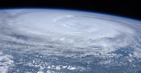
Under Debate: Social Media’s Value For Delivering Hurricane News. Can we rely on Twitter, Instagram and Facebook for the biggest weather stories? How do we insure that consumers are getting information from trusted, verified sources? Here’s an excerpt of a very interesting story at The Palm Beach Post: “Their grandparents learned of hurricanes in the newspaper, their parents on CNN. Today’s young people might get their news from their pals on Facebook. And what about the generation after that? That’s what really scares some weather forecasters and emergency managers. “Twitter can be wrong and we can’t,” Jim Forsyth, news director of San Antonio news radio station WOAI, told a session of this week’s National Hurricane Conference in Austin, Texas…” (Hurricane Irene file image: NASA).
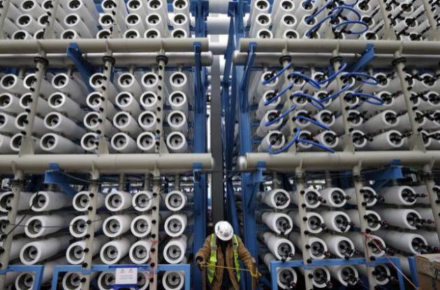
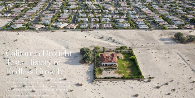
Will Turning Sea Water Into Drinking Water Help Drought-Hit California. Desalination plants are still prohibitively expensive and energy-intensive. But Santa Barbara is dusting off an old initiative to turn sea water into drinking water, a trend which may expand to other coastal cities suffering through prolonged drought. Here’s a clip from NPR: “…That briny waste is one of many concerns raised by environmentalists and other critics of desalination plants like this one and others that are being planned and built along the California coast. “The biggest concern about desalination is that it is expensive, it’s energy-intensive and it has a lot of side effects — a lot of unintended consequences to marine life both from the intake and the discharge,” says Marco Gonzalez, the executive director of the Coastal Environmental Rights Foundation. Right now, the sources of electricity available to run desalination plants are not environmentally friendly…”
File photo credit above: “In this March 11, 2015, file photo, a worker climbs stairs among some of the 2,000 pressure vessels used to convert seawater into fresh water through reverse osmosis in the western hemisphere’s largest desalination plant in Carlsbad, Calif. The Carlsbad Desalination Project, scheduled to start operations in late 2015, is expected to provide 50 million gallons of fresh drinking water a day.” (AP Photo/Gregory Bull, File).


TODAY: Light rain and drizzle. Winds: NE 10-20. High: 42
TUESDAY NIGHT: Drizzle tapers, still chilly. Low: 35
WEDNESDAY: Drier day, skies try to brighten. High: 51
THURSDAY: Another surge of steadier rain. Wake-up: 39. High: 44
FRIDAY: Early slush in a few towns? Then gradual clearing. Wake-up: 34. High: near 50
SATURDAY: Clouds increase, probably dry. Wake-up: 38. High: 56
SUNDAY: Milder with showers, PM thunder? Wake-up: 45. High: near 60
MONDAY: Drier, breezy and cooler. Wake-up: 43. High: 52
Climate Stories….


As Young Evangelical, He Finds God’s Call in Focus on Climate “Crisis”. Here’s an excerpt of a story and interview at madison.com: “...I also believe this is an issue we can do something about,” he said. “There are often arguments about whether climate change is manmade or cyclical, which kind of misses the point.” “I believe Christians are called to be conformed to the image of God,” he added, “and throughout the Bible, we see God creating, sustaining, redeeming and delighting in creation. “We as Christians should always be looking for how we can imitate God in all things, particularly how we care for the world around us.”
Photo credit above: Doug Erickson | Wisconsin State Journal. “Riley Balikian, photographed at an entrance to the UW Arboretum, is a member of the national steering committee for Young Evangelicals for Climate Action.”
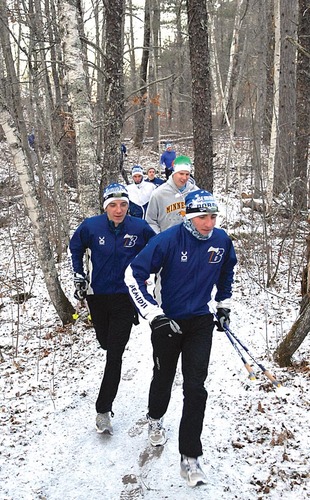
Climate Experts Called In To Save Skiing. I read this curious and vaguely alarming article in the Norwegian press; here’s an excerpt from newsinenglish.no: “Norwegian sports officials are applying to host the Nordic Ski World Championships in Trondheim in 2021, even though the prospects for having enough snow are increasingly bleak. They’re seeking help from local climate experts to make sure they’ll be able to carry out the huge international competition, and ensure the future of a sport that in Norway is part of the cultural heritage…”
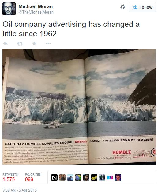
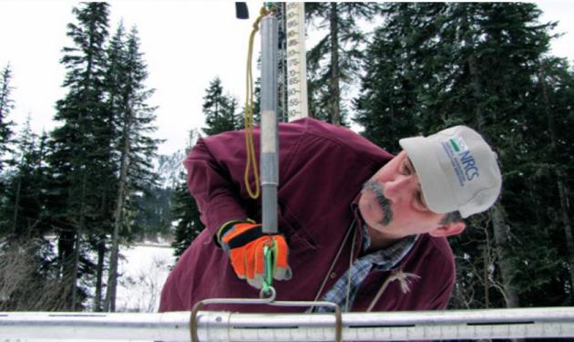
Photo credit above: “Scott Pattee, a water supply specialist with the National Resources Conservation Service, checks snow levels at Stevens Pass ski resort in Washington’s Cascade Mountains.” Credit: Ashley Ahearn/KUOW.
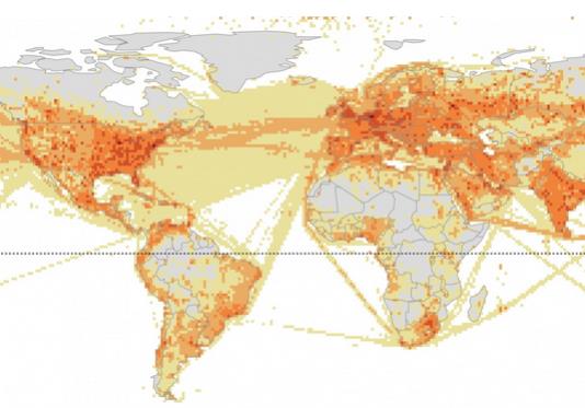
The Whole Globe is Warming – But Look At How Much Of It Is Cause By The Northern Hemisphere. Chris Mooney takes a look at the geopolitical implications of CO2 emissions in a story at The Washington Post; here’s an excerpt that caught my eye: “…The Northern Hemisphere, home to almost 90 percent of the world’s population, is where the majority of atmospheric carbon dioxide originates,” writes Elliott. Indeed, of the world’s top ten cumulative greenhouse gas emitters from 1850 to 2011, only two, Brazil and Indonesia, are at least partly situated the southern hemisphere (and each has contributed about 1 percent of the global total). These are not just idle observations — the situation has significant implications for the difficult international politics of climate change…”
Infographic credit above: “Where carbon emissions are greatest“. (Kennedy Elliott).
