Observed Lows Wednesday Morning Across Minnesota
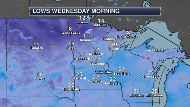
______________________________________________
Cool Start To November Across The State
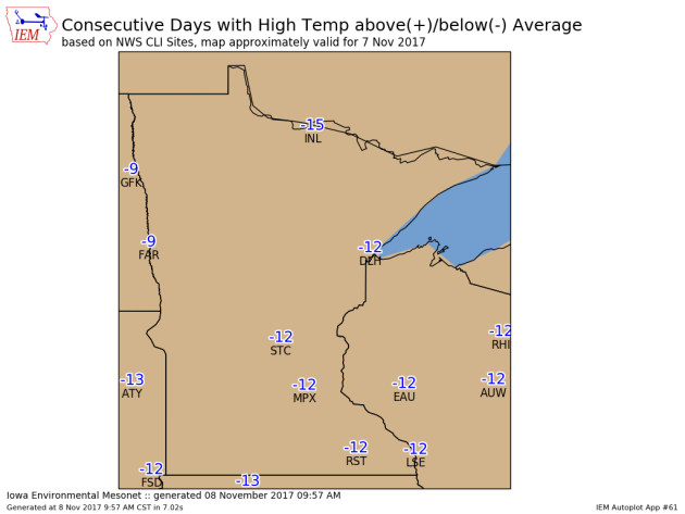
Brr! It has been a chilly start to the month across the state of Minnesota. So far we have seen below average highs each day, and when you combine those highs with the overnight temperatures, the overall average temperature each day has ended up below average as well. Wednesday will mark the 13th day in a row with a below average high (the chart above from the Iowa Environmental Mesonet goes through Tuesday) in the Twin Cities, and will be extended to two weeks in a row Thursday. Meanwhile, International Falls has already observed over two weeks in a row with below average highs.
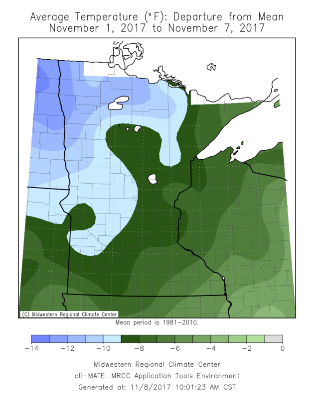
Parts of the state so far (through Tuesday) have recorded an average temperature that has been at least 10 degrees below average through the first seven days of the month. We have more cold weather on the way into the weekend – but it does look like a warm up is possible heading into next week. More on that in a moment!
______________________________________________
Ski Season… Already!

Ready for ski season? Powder Ridge up in Kimball is! They’ll be open this weekend, which according to their email would be the earliest they have ever opened. This would certainly be one way to get out and actually enjoy the cold air this weekend.
______________________________________________
A Taste of January – Few 40s Return Next Week
By Paul Douglas
There is no such thing as bad weather – only inappropriate clothing choices. A reader, Craig Richmond, had this advice: “Paul – please do not mention the wind-chill factor without clarifying that this only applies to exposed skin.” This is true. If you’re dressed appropriately and physically active the wind chill is an annoyance, not a show-stopper. Waiting for the bus in a light jacket? You may feel discomfort this morning, as the chill factor dips into single digits. Fresh air!
Today will be perfectly normal for January; the 14th day in a row of colder than average temperatures. But a thaw is coming: 40F by Saturday with a few days in the 40s next week. No big storms of any flavor brewing; a weekend mix may slide south of Minnesota.
In spite of this cold spell 2017 is forecast to be the 2nd or 3rd warmest on record, worldwide. 16 of the last 17 years have been among the warmest on record, worldwide. October was the 391st month in a row warmer than the 20th century average.
Yes, it’s cold out there. That’s weather ups and downs – superimposed on a long-term warming trend.
______________________________________________
Twin Cities Extended Forecast
THURSDAY: Numb and number. High 23. Low 12. Chance of precipitation 10%. Wind NW 10-20 mph.
FRIDAY: Cold, sunny start, clouds increase. High 30. Low 26. Chance of precipitation 20%. Wind SE 10-15 mph.
SATURDAY: Overcast, a bit milder. High 41. Low 29. Chance of precipitation 20%. Wind S 7-12 mph.
SUNDAY: Precip may stay south. Patchy clouds. High 39. Low 27. Chance of precipitation 20%. Wind NW 7-12 mph.
MONDAY: Partly sunny. I can feel my toes! High 43. Low 32. Chance of precipitation 10%. Wind S 8-13 mph.
TUESDAY: Clouds increase, almost “mild”. High 48. Low 33. Chance of precipitation 20%. Wind S 10-15 mph.
WEDNESDAY: Intervals of sun, cooler breeze. High 40. Low 27. Chance of precipitation 10%. Wind NW 8-13 mph.
_______________________________________________
This Day in Weather History
November 9th
1999: A November ‘heat wave’ impacts much of the state. Temperatures in the 70’s and 80’s are recorded in Minnesota with records shattered in many places. The Twin Cities had 73 degrees, while Canby saw 82.
1943: A severe ice storm hits the Twin Cities, and heavy snow falls over southwest Minnesota. One person died in St. Paul as a trolley car slid off the tracks and hit a pole. A Minneapolis man died shoveling snow. Many telephone poles were down due to the ice. Places like Worthington, Windom, and Marshall saw 14 to 16 inches of snow.
1870: The first storm warning for the Great Lakes is issued by the U.S. Army.
_______________________________________________
Average Temperatures & Precipitation for Minneapolis
November 9th
Average High: 45F (Record: 70F set in 1999)
Average Low: 30F (Record: 12F set in 1945)
Average Precipitation: 0.06″ (Record: 1.28″ set in 1970)
Average Snow: 0.2″ (Record: 4.5″ set in 1983)
________________________________________________
Sunrise/Sunset Times for Minneapolis
November 9th
Sunrise: 7:02 AM
Sunset: 4:50 PM
*Length Of Day: 9 hours, 47 minutes and 31 seconds
*Daylight Lost Since Yesterday: ~2 minute and 34 seconds
*Latest Sunrise At/After 7:30 AM: November 30th (7:30 AM)
*Earliest Sunset: December 5th-13th (4:31 PM)
________________________________________________
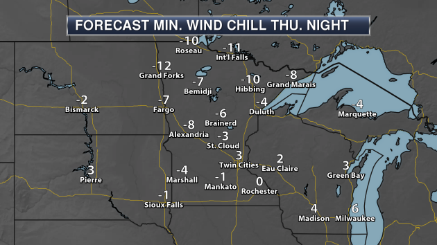
Minnesota Weather Outlook
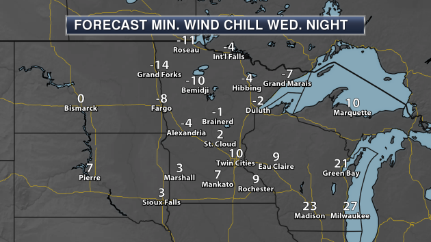
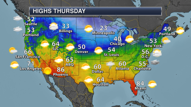
First, make sure you bundle up as you head out Thursday morning! It’ll feel like the teens below zero across parts of northern Minnesota, but even in southern Minnesota it’ll only feel like the single digits above zero.
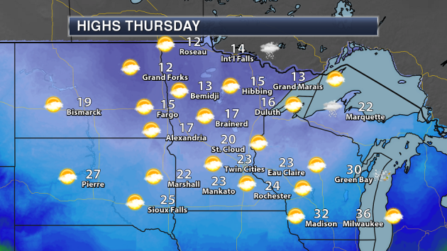
Behind a cold front passing through the state Wednesday and Wednesday Night, Thursday will be downright cold across the state. Highs will only be in the 20s across southern Minnesota, and they won’t make it out of the teens in northern parts of the state. Some snow may be possible very early Thursday morning in the International Falls area, otherwise mainly sunny skies can be expected across the state.
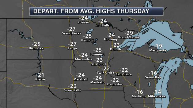
Looking at this map personally makes me sad… as highs will be a good 20-30 degrees below average for this time of year Thursday across the state. Can anyone say BRRRRR!
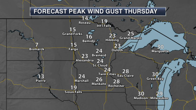
Along with the chilly air expected Thursday across the state, winds will be strong out of the northwest. We could see gusts in the 20 mph range across a good portion of the state – making that cold air feel even colder!
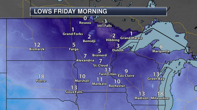
And the chill will continue Friday morning, with numerous areas of the state expected to see single digits for lows. Areas like International Falls and Hibbing are expected to drop below zero! The last time we saw a low of 11 or colder in the Twin Cities was back on March 14th (9 degrees) so this will be the coldest we’ve been in about eight months.
It’ll feel even colder as you head out the door Friday morning, with wind chill values below zero expected across most of the state.

Friday could be another windy day across parts of Minnesota, with winds potentially topping 30 mph in southwestern parts of the state.
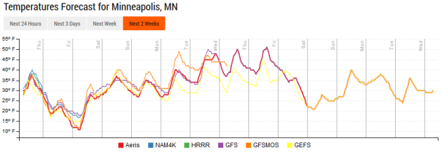
There is a bright spot in the extended forecast, as models have us back in the 40s and 50s for highs by the middle of next week – which would be above average for this time of year.
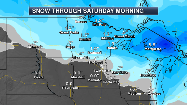
With a system passing through late Wednesday into Wednesday Night across the region, some mainly light snow can be expected across northern and central Minnesota – mainly along and north of I-94. Toward the Twin Cities snow amounts are expected to be light, with the potential of 1-3″ across northern Minnesota.
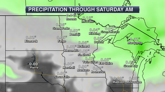
We could see up to a tenth of an inch of melted precipitation in the snow that falls late Wednesday into Wednesday Night.
______________________________________________
National Forecast
Showers and storms will be possible from far southern Texas through the Mid-Atlantic Thursday near a cold front that continues to move south. A second system with associated cold front will be moving across the Great Lakes into the Northeast, bringing chances of snow to the Great Lakes and a mix of rain and snow to parts of the Northeast. That will also usher in much cooler air with it. A third system will move onshore over the West Coast Wednesday night into Thursday, bringing rain and high elevation snow.
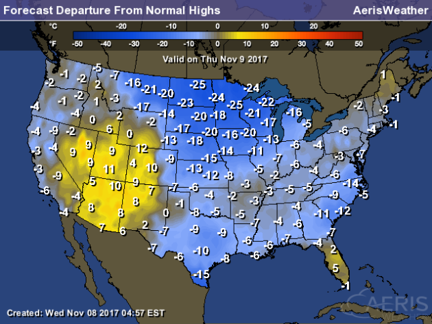
Most of the country will see below average temperatures Thursday, with warmer than average temperatures across parts of the Central Great Basin and Southwest, Florida and northern Maine. Highs across parts of the upper Midwest will be 15-25 degrees below average.
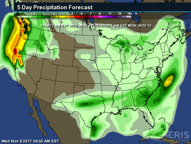
With rain chances likely through the end of the week and into the weekend across the Pacific Northwest, we could see 2-4″+ of rain from northern California into western Washington through Monday morning.
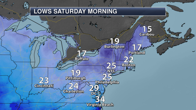
Meanwhile, behind that cold front that will be moving through the Northeast the next couple days, cold weather is expected to begin the day Saturday across the region. Lows are expected in the 20s from Boston to Washington D.C., with teens for areas like Caribou, Burlington and Buffalo.
______________________________________________
Lake Effect Clouds
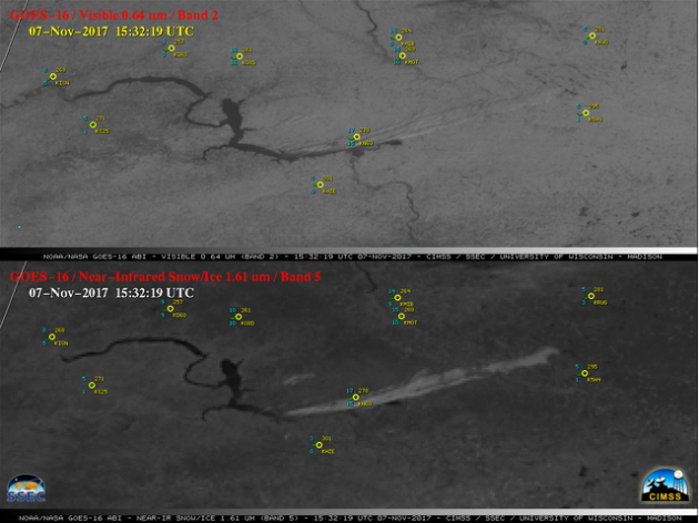
You’ve heard of lake effect snow… but what about lake effect clouds? Those were visible Tuesday in parts of North Dakota. More from CIMSS: “As cold arctic air continued to move eastward across North Dakota on 07 November 2017, GOES-16 “Red” Visible (0.64 µm) and Near-Infrared “Snow/Ice” (1.61 µm) images (above) showed “lake effect” cloud plumes streaming east-northeastward from Lake Sakakawea and the Missouri River. The Snow/Ice images were the most useful for discriminating between supercooled water droplet cloud plumes (brighter shades of white) and the surrounding snow-covered land surfaces (darker shades of gray).”
Drought Affecting Hunting In Montana
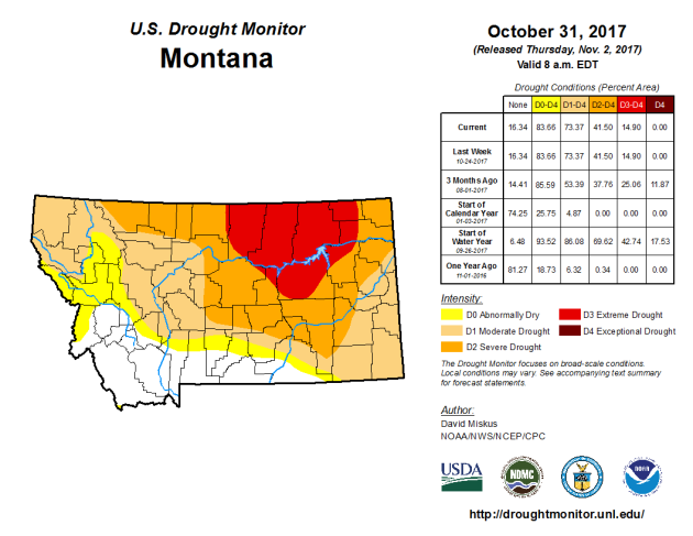
Drought in Montana this year has greatly reduced the amount of birds like pheasant and grouse available to hunt in the Havre area. More from the Havre Daily News: “While there is no indication this year’s drought reduced big-game availability, there is some evidence to suggest that may be the case for birds. Drought has affected pheasant, grouse and Hungarian partridge harvest numbers, Hemmer said. “Those are all down about 50 percent – some over, some under – but pheasant were down like 47 percent, long term,” Hemmer said. “Sharp-tailed were 58 percent down for long term. We don’t see a lot of Hungarian partridge anyway, but those were down 52 percent.”
Earth Could Be A “Ball Of Fire” 600 Years From Now
The future of Earth could be doomed in 600 years according to Stephen Hawking. Why? More from CNET: “Better cancel any plans you’ve made for the year 2617 — renowned physicist Stephen Hawking thinks we Earthlings could all be toast by then. Hawking made a video appearance at the 2017 Tencent WE Summit in Beijing on Sunday, and warned that overcrowding and increased energy consumption could bring a fiery end to our world. The end would come in a “ball of fire,” USA Today quotes Hawking as saying.”
______________________________________________
Thanks for checking in and have a great Thursday! Don’t forget to follow me on Twitter (@dkayserwx) and like me on Facebook (Meteorologist D.J. Kayser)!
– D.J. Kayser

