Snow Drought So Far Across Most Of Minnesota, Upper Midwest
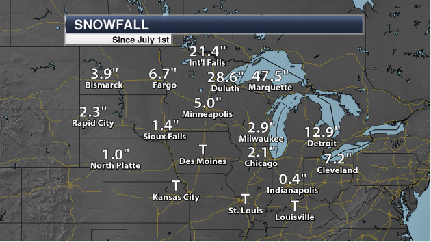
Through Friday, we have only received 5″ of snow so far this season in the Twin Cities, while we should average 16″ of snow by now. The heaviest snow so far has fallen across parts of northern Minnesota, which have been more in the path of storm systems moving through the region. Both Duluth and International Falls have received over 20″ of snow so far this winter. The snow total in Duluth was helped by the late October storm that brought them 10.6″ of snow on the 27th.
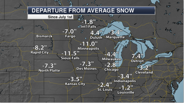
Most locations across the upper Midwest are below average for snow so far this winter, with the only places above average being Duluth and Detroit. Even Marquette, which has received 47.5″ of snow so far is 3.4″ below average.
_______________________________________________
One of the Colder Christmases In Recent Memory?
By Paul Douglas
The hype is warranted, the rumors are true. One of the two or three coldest smacks of winter arrives by late week. By Christmas Day temperatures struggle to reach zero, nighttime lows slip to -10F. Not quite record territory but cold enough to do your funny Nanook of the North impersonation.
My father and sister are traveling to Minnesota for Christmas, and they have serious concerns. “How do
we dress for subzero?” Bring extra clothes, a few extra layers. Sensible shoes (boots) and earmuffs help. “Can we go outside?” Absolutely. Just keep moving and you’ll be just fine. The sensation is roughly equivalent to bathing in battery acid. Amazingly, you get used to it.
No weather drama into Tuesday. A mix of light snow and ice arrives Wednesday. Heavier snow is possible Thursday into Friday. Right now models take the heaviest snow band over southeastern Minnesota, but confidence levels are low. We’ll get our white Christmas. ECMWF guidance hints at single digit highs from December 23-27.
The GFS brings in 20s by New Year’s Day. You’ll be amazed just how good 20s above can feel.
_______________________________________________
Extended Twin Cities Forecast
SUNDAY: Mostly cloudy, dry. High 30. Low 23. Chance of precipitation 20%. Wind NW 3-8 mph.
MONDAY: Still gray, but noticeably milder. High 40. Low 28. Chance of precipitation 20%. Wind SW 8-13 mph.
TUESDAY: Peeks of sun, still above average. High 35. Low 20. Chance of precipitation 10%. Wind NW 10-15 mph.
WEDNESDAY: Light snow, roads may ice up. High 28. Low 23. Chance of precipitation 70%. Wind E 8-13 mph.
THURSDAY: Few inches of snow possible. High 25. Low 6. Chance of precipitation 90%. Wind NE 10-20 mph.
FRIDAY: Peeks of sun, dress in layers. High 15. Low 3. Chance of precipitation 20%. Wind NW 7-12 mph.
SATURDAY: Few flakes, wind chill close to -10F. High 9. Low -7. Chance of precipitation 30%. Wind NW 10-15 mph.
_______________________________________________
This Day in Weather History
December 17th
1996: 20 to 40 mph winds combined with recent snowfall produce blizzard like conditions for about a 36 hour period over much of the area. Whiteout conditions are common in rural and open areas. Every county road in Yellow Medicine county was impassable by the morning of the 18th. Travelers heading west were stranded in Clara City as plows were pulled off the road. Wind chills were as low as 60 degrees below zero.
1946: Heavy snow is reported along with strong wind across northern Minnesota. Duluth has winds up to 62 mph.
_______________________________________________
Average Temperatures & Precipitation for Minneapolis
December 17th
Average High: 26F (Record: 53F set in 1939)
Average Low: 12F (Record: -17F set in 1985)
Average Precipitation: 0.03″ (Record: 0.81″ set in 1908)
Average Snow: 0.4″ (Record: 10.8″ set in 1908)
_______________________________________________
Sunrise/Sunset Times for Minneapolis
December 17th
Sunrise: 7:45 AM
Sunset: 4:32 PM
*Length Of Day: 8 hours, 46 minutes and 50 seconds
*Daylight Lost Since Yesterday: ~0 minutes and 21 seconds
*Latest Sunrise: December 30th-January 5th (7:51 AM)
*Next Sunset at/after 5 PM: January 17th (5:00 PM)
_______________________________________________
Minnesota Weather Outlook
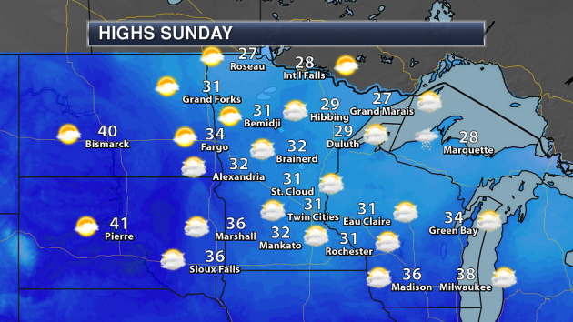
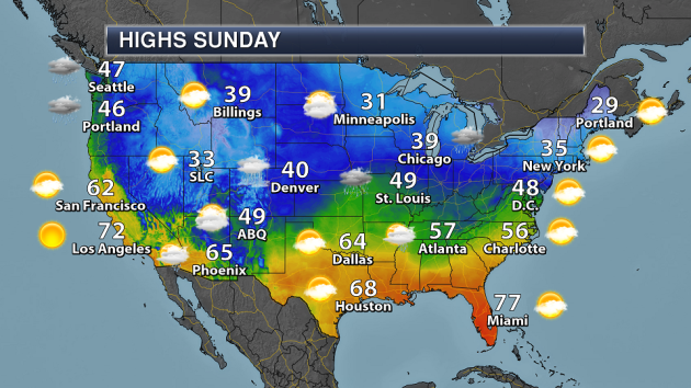
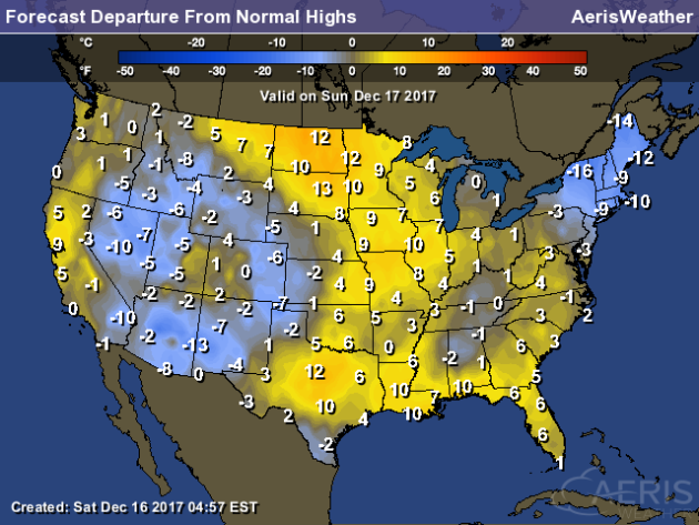
Skies will once again be mainly cloudy across the state Sunday, but potentially with a few more peaks of sun in spots. Highs will climb into the low 30s across southern Minnesota and mid/upper 20s across northern Minnesota.
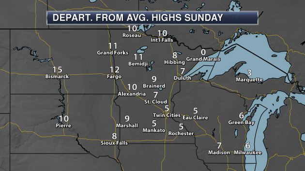
Even though we may barely make it to freezing in the Twin Cities Sunday that is above average for this time of year. Across most of the state, highs will be a good 5-15 degrees above average.
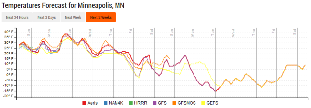
A dip in the temperatures will come as we head toward the end of the week and into the holiday weekend as frigid temperatures move south of the border. By the end of the work week, we could see our first high in the teens so far this winter in the Twin Cities. The coldest high we’ve observed so far was 20 on December 6th. Another surge of cold air appears to arrive just in time for Christmas, with some models indicating we might only make it into the single digits on Christmas Day.
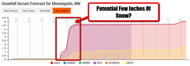
That cold air will come in behind a system that’ll bring at least the chance of some accumulating snow next Wednesday into Thursday to the region. Right now models are still showing a wide selection of scenarios that could happen with this system, so it’s certainly too early to start putting snowfall totals out. Just know that travel toward the middle to end of the week at the moment may be interrupted by at least a few inches of snow, and we’ll keep narrowing down how much snow will fall over the next few days.
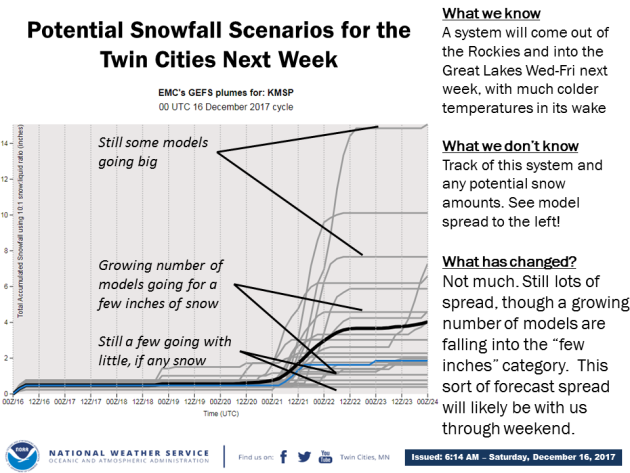
This graphic from the Twin Cities office of the National Weather Service shows that wide spread of possibilities in the models for the Wednesday-Thursday system. Again, it’s too early to tell how much will fall… especially when the model spread is 0″-14″.
_______________________________________________
National Weather Stories
A frontal system draped from the Great Lakes to southern New Mexico will help produce some rain and snow showers across portions of the Great Lakes, Northeast, and Arizona/New Mexico Sunday. A low across Louisiana could help produce showers and storms along the western and northern Gulf Coast and in parts of the Southeast. A frontal system moving toward the Pacific Northwest will help produce rain and snow.
Warmer than average temperatures will be found in parts of the central United States into the Northern Plains and Southeast on Sunday, with cooler than average highs across the Northeast and the Great Basin and Southwest.
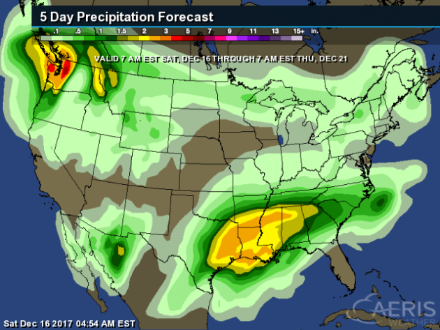
A frontal system will stall out as we head into next week across portions of the South and Southeast, leading to potentially rounds of showers and storms across the regions. Rainfall totals through Thursday morning could top 2-3″ in spots. Heavy precipitation will also be found in the Pacific Northwest as we start to see more systems approach the coast.
_______________________________________________
Praedictix Weather Corporate Briefing On The California Wildfires Issued Early Saturday Morning:
- Multiple major wildfires continue across parts of southern California early Saturday morning. Three of the six wildfires that started last week are now contained, with another two 98-99% contained. The last one – the Thomas Fire – is the fourth largest California wildfire in modern history.
- An update on the active wildfires:
- The Thomas Fire continues to burn northwest of Los Angeles. The fire has burned 256,000 acres so far and is 35% contained. According to Cal Fire, the fire has cost more than $96.9 million so far. Numerous mandatory evacuations remain in place – here are evacuation maps for Ventura County and for Santa Barbara County. Both Ventura County and Santa Barbara County are keeping their local government pages updated with evacuation orders, road closures, and other relevant information like evacuation shelters. Inciweb also has more on the fire.
- The Creek Fire has burned 15,619 acres and is 98% contained. Inciweb has more information.
- The Lilac Fire has burned 4,100 acres and is 99% contained. Cal Fire has more information.
- Critical fire danger is expected over the next couple days across California – in both the Bay Area and areas surrounding Los Angeles. Gusty winds and low humidity values will allow any new and ongoing wildfires to quickly spread across the region.
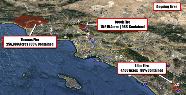
Ongoing Wildfires. Three major wildfires continue to burn across southern California early this morning. The Thomas Fire has grown to 256,000 acres burned and is 35% contained. Here was the situation on the Thomas Fire from the Cal Fire incident report last night:
Tonight (Friday Night) and into tomorrow (Saturday) morning, strong north winds are forecast to materialize. This has the potential to amplify fire behavior significantly above the coastal communities of Santa Barbara County, as well as the Fillmore area. Critical fire weather combined with very high fuel loading, critically low fuel moistures, and single-digit relative humidities will continue to support fire growth. Areas of concern are above the coastal Santa Barbara County communities, Matilija Wilderness, Rose Valley, and Sespe River drainage north of Fillmore
Santa Barbara County: Firefighters will remain prepared for structure defense operations and continue direct line construction above the communities of Santa Barbara, Carpinteria, Summerland, and Montecito.
Ventura County: Improvement and mop up of fireline in the Fillmore area will continue. Fire in the Bear Wallow area and Day Fire footprint will remain in monitor status. In the north, direct line construction will continue within the Zaca Fire footprint, tying in to Highway33.North winds will also exasperate the threat to Fillmore and surrounding agricultural values, with fire backing into the Sespe drainage.
A detailed, interactive map of the fires can be found HERE.
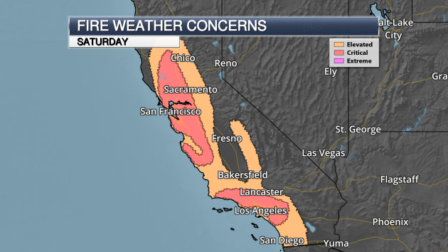
Critical Fire Danger Today. Critical fire danger continues today across California as a system passes through the Great Basin. That will be followed by high pressure moving into the Great Basin by tonight.
- Across northern and central California, gusty north winds are already occurring this morning and will continue throughout the day. Humidity values are also falling. The combination of the two will lead to critical fire weather concerns throughout the day.
- Across southern California, strong winds are already occurring across parts of Santa Barbara County and will continue through the day. As we head toward this evening, gusty Santa Ana winds will return to the rest of Southern California, with gusts up to 50 mph and falling humidity values.
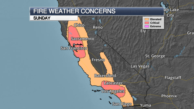
Critical Fire Danger Continues Into Sunday. Critical fire danger will remain in place across California as we head into Sunday.
- Across northern and central California, the critical fire weather concern will mainly be during the morning hours, as winds will be on the decrease into the afternoon. However, at least an elevated fire weather concern will continue into the second half of the day as some stronger winds gusts will be possible, especially at higher elevations.
- In southern California, strong Santa Ana winds and low humidity values will continue throughout the day, fanning any new and ongoing wildfires.
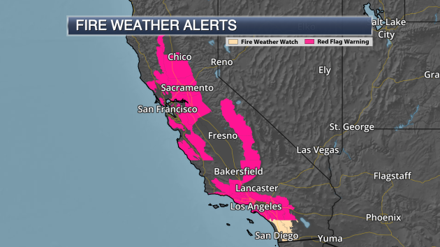
Red Flag Warnings & Fire Weather Watches. Due to the continued fire weather conditions – including gusty winds and low humidity values – Red Flag Warnings are in effect across portions of California over the next couple days.
- Across northern and central California, including warnings in both the Bay Area and around Sacramento, they are in effect through 10 AM Sunday. This is due to low humidity values and northerly winds which will gust to around 50 mph, especially at higher elevations.
- Across the Sierra and Kern County mountains, Red Flag Warnings are in effect through this evening due to low humidity values and winds that will be out of the northeast at 10-20 mph by this afternoon.
- In the Santa Barbara County Mountains and adjacent foothills, Red Flag Warnings are in effect through 10 PM today due to northerly winds gusting up to 40 mph and low humidity values.
- Across the rest of southern California, Red Flag Warnings go into effect either tonight or early Sunday morning, lasting through Sunday evening. This is due to northeast winds gusting at 40 to 50 mph (with isolated gusts to 60 mph possible)
Across parts of San Diego County, a Fire Weather Watch is in effect from 8 AM to 8 PM Sunday. Winds are expected to gust out of the northeast at 35-45 mph, with low humidity values in place.
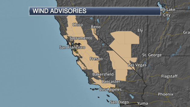
Wind Advisories In Effect. Due to the gusty northerly winds expected across the region over the next couple days, Wind Advisories are in place. Winds are expected to gust between 35-50 mph, with isolated higher gusts possible.
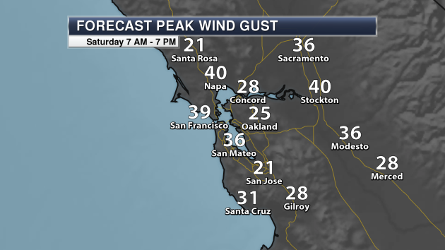
Bay Area Wind Gusts Today. Peak wind gusts are expected to be between 20-40 mph across the Bay Area and into higher elevation areas throughout the day. This would allow any fires that spark across the region to quickly spread.
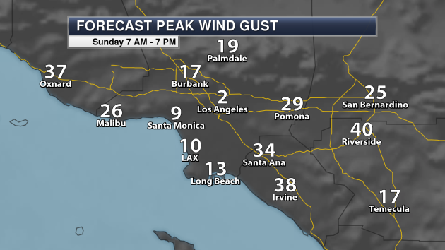
Los Angeles Wind Gusts Sunday. Wind prone areas of the Los Angeles area will see strong northeast winds due to a Santa Ana event tonight into Sunday. Peak wind gusts could top 40-50 mph in areas Sunday.
Meteorologist D.J. Kayser, Praedictix
_______________________________________________
California Wildfires Affecting Our Oceans

So just how do wildfires end up affecting the ocean? It has to do with the ash that comes from everything burning. More from Popular Science: “The Santa Barbara Channel, an 80-mile-long stretch of the Pacific Ocean just off the coast of southern California, is one of the most diverse and vibrant ocean ecosystems in the world. On Saturday, a team of scientists led by Kelsey Bisson and Nicholas Huynh, doctoral students in oceanography at the University of California at Santa Barbara, will board the research vessel Sally Ride and set off on a week-long expedition to study the organisms living there.”
What Season Is It In Denver Right Now?
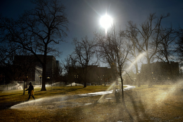
Here’s an uncommon sight this time of year: green grass in Denver. More from the Denver Post: “Denver plants that are supposed to be brown, scraggly and dead this time of year are instead green, flourishing and alive. From dandelions and pansies to trees and lawns, plants are popping up, budding and thriving, clearly feeling confused about when they’re supposed to go dormant this season — if at all.” (Image: Denver Parks and Recreation runs the sprinklers to keep up with the warm dry weather at Civic Center Park while workers also repair broken sprinkler heads and do general maintenance in downtown Denver on Dec. 12, 2017. Joe Amon, The Denver Post)
Sierra Grows In Height During Recent Drought
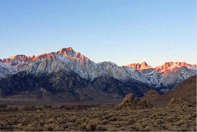
Due to the drought over the past few years out in California, the Sierra Nevada actually rose in elevation. More from U.S. News: “Loss of water from rocks during drought caused California’s Sierra Nevada to rise nearly an inch (2.5 centimeters) in height from October 2011 to October 2015, according to a new NASA study made public Wednesday. The study also found that in the following two years of increased snow and rain, the rocks in the range regained about half as much water as was lost during the drought and the return of the weight caused the height of the mountains to fall about half an inch (1.3 centimeters).” (Image: This Dec. 21, 2016 photo shows the eastern Sierra Nevada, with Mt. Whitney, the second-highest peak in the U.S., the largest of three pinnacles at center, near Lone Pine, Calif. Loss of water from rocks during drought caused California’s Sierra Nevada to rise nearly an inch in height from October 2011 to October 2015, according to a new NASA study made public Wednesday, Dec. 13, 2017. The study also found that in the following two years of increased snow and rain, the rocks in the range regained about half as much water as was lost during the drought and the return of the weight caused the height of the mountains to fall about half an inch. (AP Photo/Brian Melley))
________________________________________________
Thanks for checking in and have a great Sunday! Don’t forget to follow me on Twitter (@dkayserwx) and like me on Facebook (Meteorologist D.J. Kayser)!
– D.J. Kayser

