____________________________________________________________________________
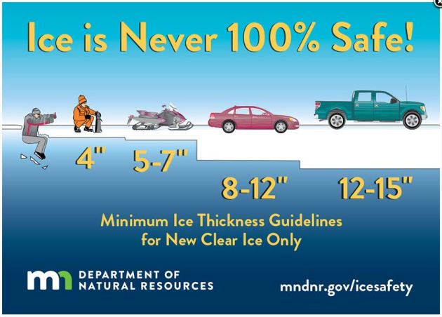
Under 4″ – STAY OFF
4″ – Ice fishing or other activities on foot
5″ – 7″ – Snowmobile or ATV
8″ – 12″ – Car or small pickup
12″ – 15″ – Medium truck
Many factors other than thickness can cause ice to be unsafe.
White ice or “snow ice” is only about half as strong as new clear ice. Double the above thickness guidelines when traveling on white ice.
_________________________________________________________________________
Weather Outlook Ahead
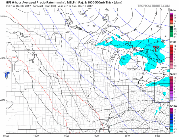
Here’s the weather outlook from Sunday to Monday, which shows another fast moving clipper racing across the region with more light snow. It doesn’t look like much, but there could be another light coating for folks across northern MN and into WI.
___________________________________________________________________
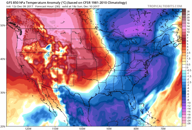
Cold Air Continues Acorss the Eastern Half of the Country
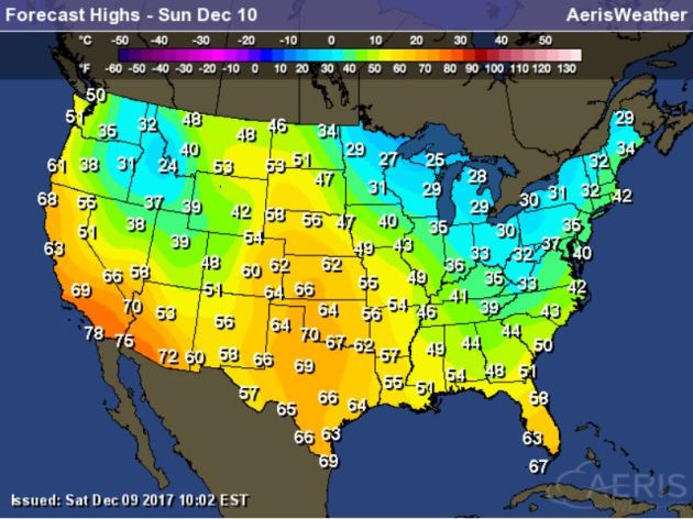
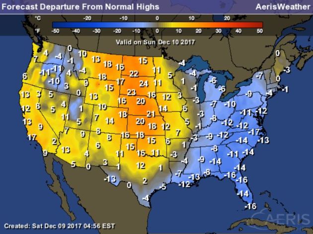
High Temps Sunday
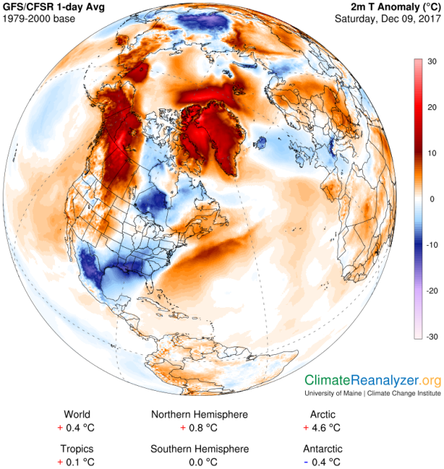
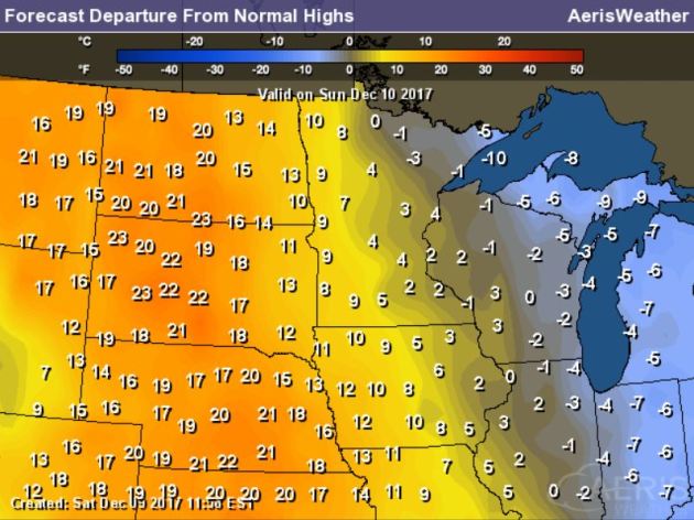
High temperatures on Sunday will still be VERY chilly across the third of the country with temperatures running nearly 10F to 15F below average. Meanwhile, warmer than average temperatures will continue in the Western half of the country and especially across the Plains where temps will be nearly 20F to 25F above average.
.gif)
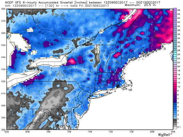
According to NOAA’s WPC, the 5 day precipitation outlook suggests areas of heavier precipitation continuing across the Northeastern part of the country through the weekend. There will also be areas of heavier precipitation across the Great Lakes as another clipper rolls through, which will turn on the lake effect snow machine. Note how dry the Western US will be through the week ahead.
.gif)

__________________________________________________________________________
Praedictix Briefing: Saturday, December 9th, 2017
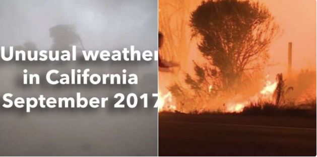
- Multiple major wildfires continue across parts of southern California Saturday morning, with almost 175,000 acres consumed since Monday.
- Power outages continue in the areas affected by fires. Late last night, Southern California Edison reported approximately 4,300 customers without power due to the four fires north of Los Angeles, and San Diego Gas & Electric reported 5,000 without power due to the Lilac Fire.
- Progress was made on many of the fires across the region Friday. Breaking down the major wildfires in the region:
- The Thomas Fire has burned 148,000 acres and is 10% contained. According to Cal Fire: “The fire continues to threaten structures in various parts of the cities of Ventura, Ojai, Casitas Springs, Santa Paula, Carpinteria, Fillmore and the unincorporated areas of Ventura County and Matilija Canyon. The fire is expected to spread towards Santa Barbara County, Sespe Wilderness and the Sespe Condor Sanctuary.”Mandatory evacuations remain in place – here is the evacuation map. Both Ventura County and Santa Barbara County are keeping their local government pages updated with evacuation orders, road closures, and other relevant information like evacuation shelters.
- The Creek Fire has burned 15,619 acres and is 70% contained. All evacuation orders have been lifted. Cal Fire has more information.
- The Rye Fire has burned 6,049 acres and is 50% contained. Conditions Fridayallowed firefighters to make “considerable” progress on the fire. Cal Fire has more information.
- The Skirball Fire has burned 475 acres and is 50% contained. Some areas are still under mandatory evacuations. The Los Angeles Fire Department has more information.
- The Lilac Fire has burned 4,100 acres and is 15% contained. Evacuation orders and warnings remain in place. Cal Fire has more information.
- The Liberty Fire has burned 300 acres and is 90% contained. All evacuations have been lifted. The city of Murrieta has more information.
- Critical fire danger continues through the weekend across southern California.
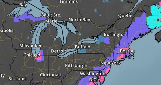
- In the Northeast, the same system that brought parts of the Southeast a half a foot of snow over the past 24 hours will impact the region today and tonight with a swath of 3-7” of snow.

Ongoing Wildfires. A half a dozen wildfires continue across southern California this morning, however conditions Friday allowed firefighers to make progress on these fires. Residents are advised to stay alert of the situation over the weekend, as conditions could quickly change. A detailed, interactive map can be found HERE.

Update From The Los Angeles National Weather Service Office. Moderate Santa Ana winds will continue through Sunday with gusts of 30 to 50 mph for the wind-prone areas of Los Angeles and Ventura Counties. These Santa Ana winds combined with humidities in the teens and single digits, along with very dry fuels, will continue to bring the extended period of critical fire weather conditions to much of Los Angeles and Ventura Counties. Extreme fire behavior with rapid fire spread and spotting is possible for ongoing fires as well as for any future fire ignitions. Caution is advised with potential ignition sources during this period of critical fire weather conditions. Continue to heed evacuation orders near active fires.

Strong Winds Continue. A Wind Advisory has been issued through 3 PM today for the Ventura County valleys/coast and the Santa Clarita Valley due to the potential of gusts up to 35 mph. Winds will increase tomorrow, likely needing more advisories across the region. To the south, High Wind Warnings are in effect for the San Diego County valleys/mountains through 4 PM Sunday. Winds today will gust up to 50 mph, with gusts to 60 mph possible tonight into Sunday morning.

Red Flag Warnings Continue. Due to the continued fire weather conditions – including strong Santa Ana winds and low humidity values – Red Flag Warnings continue across the region through Sunday evening. Here’s a portion of the updated warning issued by the National Weather Service in Los Angeles yesterday (Friday): “An extended period of Santa Ana offshore winds will continue through at least Sunday focused over much of Los Angeles and Ventura Counties. These winds will generally be in the 30 to 40 mph range through Saturday, then increase into Sunday with gusts in the 40 to 50 mph range. Meanwhile, minimum humidities of 5 to 10 percent will be common through at least the middle of next week, with widespread poor overnight recoveries mostly staying under 30 percent. As a result, critical Red Flag conditions will persist over most of Los Angeles and Ventura Counties through Sunday with a chance for locally critical at times especially in the mountains.”
Meteorologist D.J. Kayser, Praedictix
___________________________________________________________________________
It certainly has been a fairly active first half of 2017 with 1,511 preliminary tornado reports through December 8th. Note that this is the most tornadoes through that date since 2011, when there were 1,880 reports. The map below shows the distribution of the tornadoes so far this year.
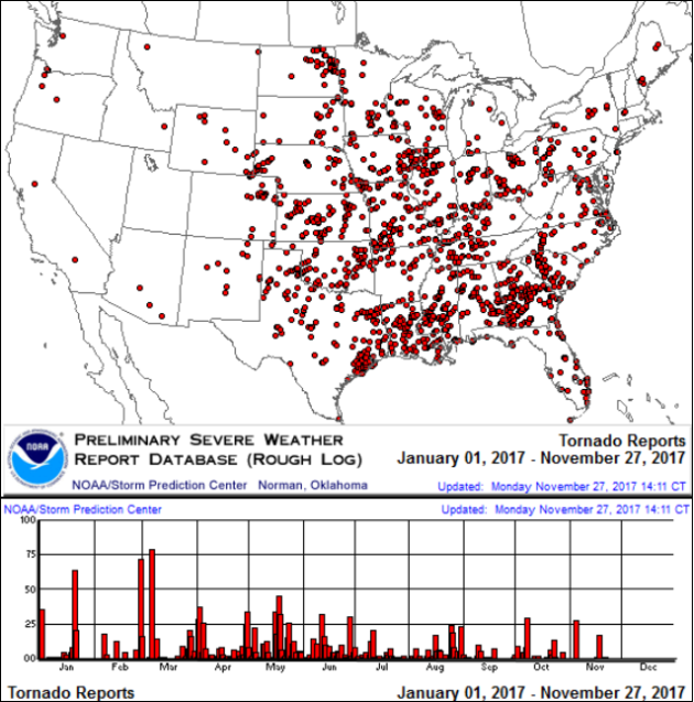
PRELIMINARY 2017 Tornado Count
According to NOAA’s SPC, the PRELIMINARY 2017 tornado count is 1,511 (through December 8th). Note that is the most active year for tornadoes since 2011, when there were 1,880 tornadoes. Notice that the only other year with more tornadoes than this year was in 2008, which ended with a whopping 2,140 tornadoes nationwide.
.png)
_____________________________________________________________________
National Weather Hazards Ahead…
1.) Heavy snow across portions of the Great Lakes, Mon-Thu, Dec 11-Dec 14.
2.) Heavy snow across portions of the Northeast, Tue, Dec 12.
3.) High winds across portions of California, Mon-Tue, Dec 11-Dec 12.
4.) Much below normal temperatures across the Great Lakes, Mon-Fri, Dec 11-Dec 15.
5.) Much below normal temperatures across portions of the Northeast and Mid-Atlantic, Wed-Fri, Dec 13-Dec 15.
6.) Much below normal temperatures across portions of Florida and the Southeast, Mon, Dec 11.
7.) Heavy precipitation across portions of the Alaska Panhandle and mainland Alaska, Mon-Fri, Dec 11-Dec 15.
8.) High winds across portions of mainland Alaska, Mon, Dec 11.
9.) High winds across portions of mainland Alaska and the Aleutians, Fri, Dec 15.
10.) Much above normal temperatures across portions of mainland Alaska, Mon-Fri, Dec 11-Dec 15.
11.) Slight risk of much below normal temperatures for portions of the Great Lakes and the Northern Plains, Fri, Dec 22.
12.) Slight risk of much below normal temperatures for portions of the Southeast, the Mid-Atlantic, and the Great Lakes, Sat-Sun, Dec 16-Dec 17.
13.) Slight risk of much below normal temperatures for portions of the Northeast, Sat-Fri, Dec 16-Dec 22.
14.) Moderate risk of much below normal temperatures for portions of the Northeast, Sat-Sun, Dec 16-Dec 17.
15.) Slight risk of heavy precipitation for the central Gulf Coast, Sun-Mon, Dec 17-Dec 18.
16.) Slight risk of heavy precipitation for portions of the Alaska Panhandle and mainland Alaska, Sat-Wed, Dec 16-Dec 20.
17.) Severe Drought across the Lower Mississippi Valley, the Northern Plains, Hawaii, the Northern Rockies, the Middle Mississippi Valley, the Southern Plains, and the Southwest.
.png)
_____________________________________________________________________
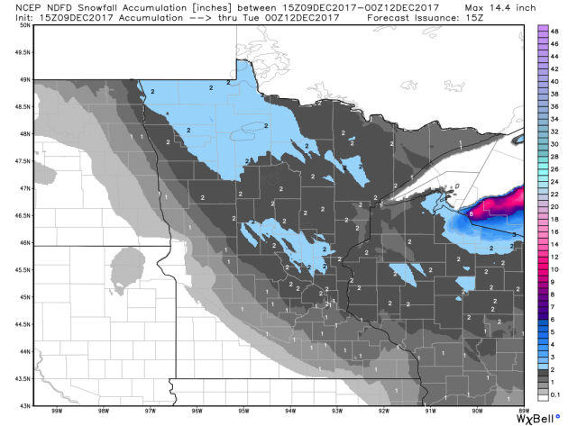
Clipper Sunday Night – Feeling an Urge to Ski Atlanta
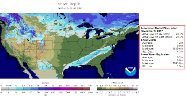
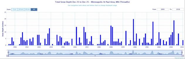
Oh, the indignity of it all for Minnesota snow lovers. 3 inches of snow has decorated the Twin Cities since Labor Day. Looking at long term averages we should have picked up closer to 13 inches, to date.
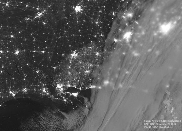
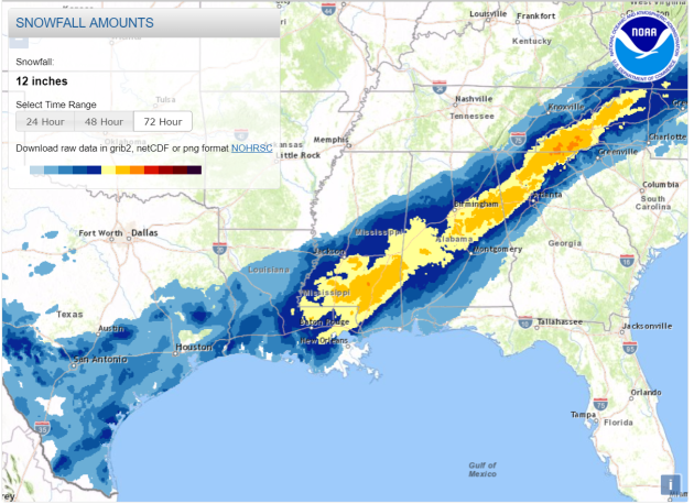
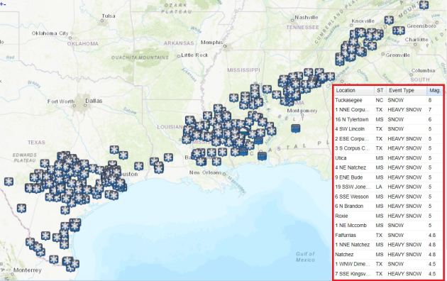
While we handicap the odds of a white Christmas snowbirds in the northwest suburbs of Atlanta are digging out from a foot of snow; 7 inches of white wonder paralyzed Corpus Christi, Texas! Yes, it’s a head-scratching weather map.
While the south and east digs out we enjoy occasional dribs and drabs of snow. An Alberta Clipper may drop a quick inch Sunday night and early Monday. Tuesday and Wednesday will feel like January, but temperatures mellow by late week; ECMWF guidance hinting at 30s and 40s a week from today. A colder surge returns the week before Christmas, and NOAA’s GFS model predicts a rain-to-snow scenario Christmas weekend. Confidence levels this far out are (laughably) low, but if the planets align we may still get our white Christmas.
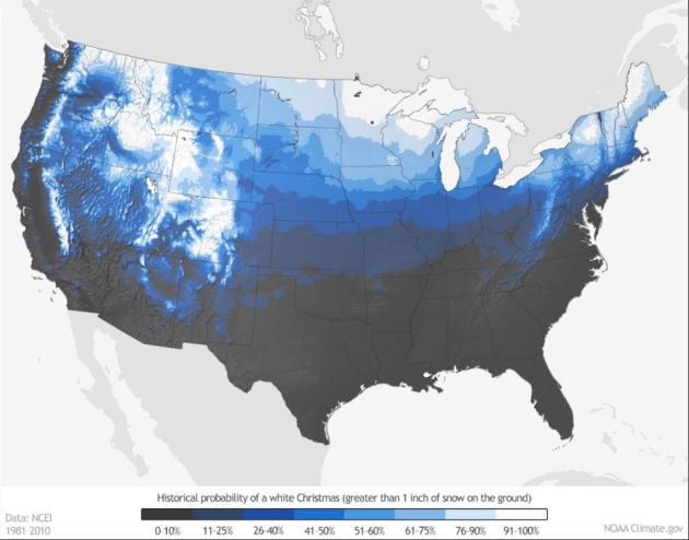
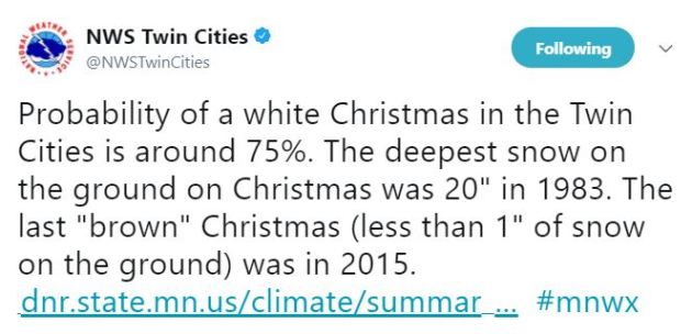
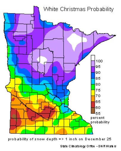
30-year climate data shows a 74 percent probability of at least an inch of snow on the ground on December 25. It’ll be a close call.
________________________________________________________________________
Extended Forecast
SUNDAY: Mostly cloudy Winds: NW 8-13. Wake-up: 13. High: 32.
SUNDAY NIGHT: Quick inch possible. Winds: WSW 5. Low: 24.
MONDAY: Windblown flakes. Gusty winds. Winds: NW 15-30. High: 32.
TUESDAY: Intervals of sun. Hints of January. Winds: NW 8-13. Wake-up: 15. High: 30.
WEDNESDAY: Weak clipper. Flurry potential. Winds: SE 8-13. Wake-up: 13. High: 25.
THURSDAY: More clouds than sun. Winds: NW 8-13. Wake-up: 20. High: 29.
FRIDAY: Patchy clouds, risk of a thaw. Winds: SE 5-10. Wake-up: 25. High: 32.
SATURDAY: Letfover clouds, but trending milder. Winds: W 7-12. Wake-u
_______________________________________________________
This Day in Weather History
December 10th
1992: By this time there is partial ice cover in the Duluth harbor.
1979: A ‘heat wave’ develops across Minnesota. Highs of 54 at Twin Cities and 57 at Winona are recorded.
1978: Alexandria ends its fourteen day stretch of low temperatures at or below zero degrees Fahrenheit.
1889: A late season thunderstorm is observed at Maple Plain.
_______________________________________________________
Average High/Low for Minneapolis
December 10th
Average High: 29F (Record: 54F set in 1979)
Average Low: 14F (Record: -18F set in 1977)
Record Rainfall: 0.61″ set in 1911
Record Snowfall: 1.8″ set in 2013
_________________________________________________________
Sunrise/Sunset Times for Minneapolis
December 10th
Sunrise: 7:40am
Sunset: 4:32pm
Hours of Daylight: ~8 hours 51 mins
Daylight LOST since yesterday: ~53 seconds
Daylight LOST since summer solstice (June 20th): 6 hours & 46 minutes
__________________________________________________________
Moon Phase for December 10th at Midnight
1.0 Days After Last Quarter Moon
.gif)
_________________________
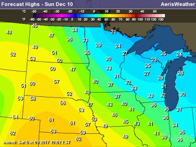
High temps on Sunday won’t be quite as chilly as it has been as of late. In fact, a few locations in southwestern Minnesota could top out in the lower 40s! The Twin Cities could briefly warm to the freezing mark, but those in northern Minnesota will still be in the 20s. Note that many across the Plains will once again be WELL above average with highs nearly 20F to 25F above average.
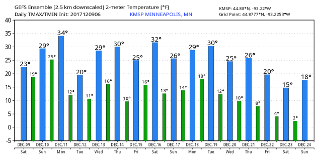
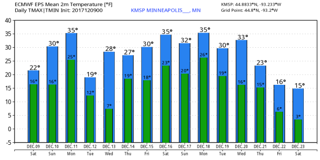
Here’s the temperature outlook from the GEFS & ECMWF modles through December 23rd/24th. Interestingly, both models are picking up on slightly warmer temperatures through Christmas now than what they were previously saying earlier this month. The GEFS keeps us in the 20s for much of the time with a few days close to or slightly above the freezing mark through the middle part of the month. However, the ECMWF is suggesting a little warmer weather with highs in the mid 30s by the 3rd week of December. Stay tuned…
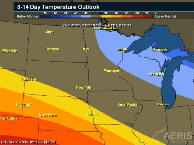
8 to 14 Day Temperature Outlook
Here’s the temperature outlook through the 3rd week of December, which suggests that the MUCH colder that is in place over the eastern third of the nation now will start to retreat a bit just before Christmas. Meanwhile, warmer than average temps might start moving back in over much of the Central US.
8 to 14 Day Temperature Outlook
Here’s the extended temperature outlook as we head through the 3rd week of December. Note that after a fairly significant surge of colder air across much of the eastern two-thirds of the nation earlier this month, we look to warm to well above average temps across much of the nation. The only cool spot will be the lingering colder air across the Northeast and Great Lakes.

__________________________________________________________________________
_____________________________________________________________________________
.jpg)
_____________________________________________________________________________
_____________________________________________________________________________
Thanks for checking in and don’t forget to follow me on Twitter @TNelsonWX