The Domebuster Snow: 7 Years Later
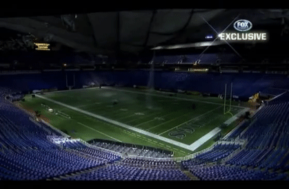
Sunday and Monday marks the fifth largest snowstorm in Twin Cities history, when 17.1″ of snow fell at the Twin Cities airport in 2010. You may remember this system as the one that busted the Metrodome roof.
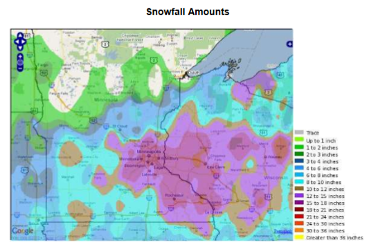
Here’s a look at the snowfall map from that system. Over the two days, the largest snow total came from the Winona Dam, where 23″ of snow fell. Again, 17.1″ of snow fell at the MSP Airport (which was closed for four hours), with 16.3″ of that falling on the 11th, marking a new record for the day. You can read more about the storm from the Minnesota State Climatology Department and the Twin Cities National Weather Service.
_______________________________________________
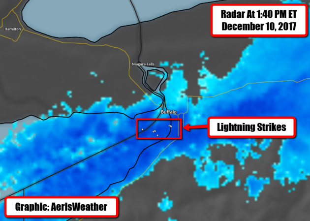
Buffalo Snow Bowl
Lake effect snow made Sunday’s football game between Indianapolis and Buffalo a literal snow bowl! Visibility was low and the teams (for the most part) relied on the running game.
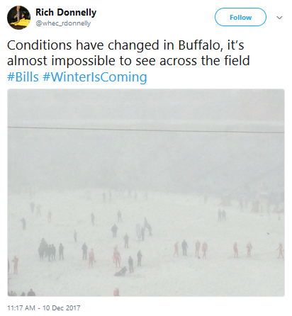
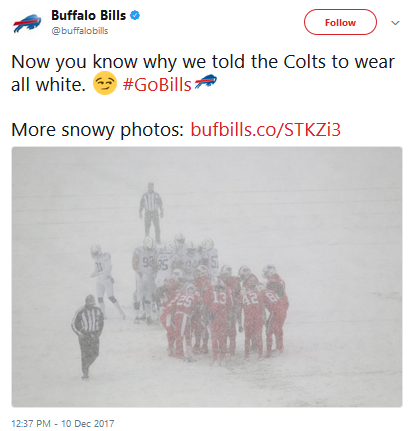

There was even some thundersnow on the eastern end of Lake Erie with the lake effect snow, as shown by lightning strikes in the area.
_______________________________________________
Temperatures At or Above Average This Week
By Paul Douglas
Pick your poison. I guess that applies to weather, too. Although Hawaii comes close, there is no such thing as “perfect weather”, anywhere on the planet.
Exhibit A: 2017. A parade of hurricanes from Harvey to Maria may have cost the U.S. $250-400 billion in damage. The New York Times reports the real death toll from Maria in Puerto Rico is over 1,000.
And this is shaping up to be the worst fire season on record for California, where blazes are burning longer and larger. I can’t think of anything more terrifying than being chased by a 100-foot wall of flames advancing at 40 mph. Climate change is a factor, but more Americans are living in dangerous places: in the woods or near the water, increasing the risk. Suddenly our cold fronts don’t look quite so bad.
Today’s Alberta Clipper drops an ill-timed inch or two of slushy snow; roads will be greasy. More clippers whip up flurries Wednesday, Saturday and next Monday, but no big, beefy storms are brewing from now into Christmas.
We’ll see a few 30s this week, but next week looks colder again. Our no-drama-December limps on.
_______________________________________________
Extended Twin Cities Forecast
MONDAY: 1-2″ snow, gusty winds. High 34. Low 14. Chance of precipitation 80%. Wind NW 15-30 mph.
TUESDAY: Partly sunny and brisk. High 25. Low 19. Chance of precipitation 10%. Wind NW 5-10 mph.
WEDNESDAY: Weak clipper, few flakes? High 31. Low 20. Chance of precipitation 40%. Wind NW 10-15 mph.
THURSDAY: Mostly cloudy with a few flurries. High 28. Low 25. Chance of precipitation 30%. Wind NW 10-20 mph.
FRIDAY: Stubborn smear of clouds, milder. High 34. Low 27. Chance of precipitation 20%. Wind SW 10-15 mph.
SATURDAY: Next clipper, dusting of flurries. High 33. Low 23. Chance of precipitation 40%. Wind NW
10-15 mph.
SUNDAY: Mostly cloudy, average for December. High 29. Low 26. Chance of precipitation 20%. Wind NW 7-12 mph.
_______________________________________________
This Day in Weather History
December 11th
2010: A blizzard hits much of southern Minnesota. Minneapolis saw a December record 16.3 inches of snow in one calendar day and much of the metro area saw between 15 and 20 inches of snow.
1983: Nine cars fall through the ice at the same time on Buffalo Lake in central Minnesota. There was only 5 to 6 inches of ice on the lake.
1979: The temperature drops in Roseville from 48 degrees at 2 pm to zero by dawn of the following day.
1916: Montevideo has its fifty-second consecutive day with no precipitation.
_______________________________________________
Average Temperatures & Precipitation for Minneapolis
December 11th
Average High: 28F (Record: 56F set in 1913)
Average Low: 14F (Record: -14F set in 1972)
Average Precipitation: 0.04″ (Record: 1.16″ set in 2010)
Average Snow: 0.4″ (Record: 16.3″ set in 2010)
_______________________________________________
Sunrise/Sunset Times for Minneapolis
December 11th
Sunrise: 7:41 AM
Sunset: 4:31 PM
*Length Of Day: 8 hours, 50 minutes and 9 seconds
*Daylight Lost Since Yesterday: ~0 minutes and 49 seconds
*Latest Sunrise: December 30th-January 5th (7:51 AM)
*Earliest Sunset: December 5th-13th (4:31 PM)
_______________________________________________
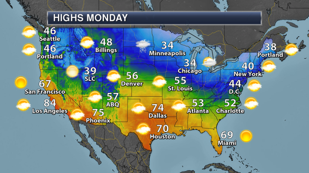
Minnesota Weather Outlook
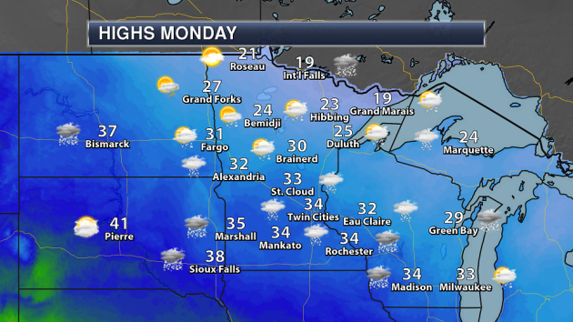
An Arctic front will move through the region Monday, but we should still see temperatures right around to just above freezing across southern Minnesota. Snow showers will be possible with the clipper moving though Sunday Night into early Monday.
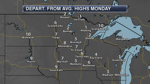
Highs will be between about 5-10 degrees above average across the southern half of Minnesota Monday, with values a lot closer to average across northern parts of the state.

Winds will be strong throughout the second half of the day across southern Minnesota, especially after the cold front works through the state. We could see wind gusts over 30 mph from the northwest here in the Twin Cities during the afternoon hours.
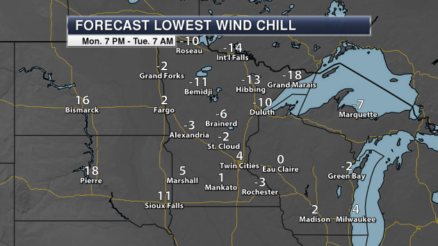
With cold air sinking in, and some strong winds at times, we will see wind chills below zero across the northern two-thirds of Minnesota Monday night and to wake up Tuesday morning.
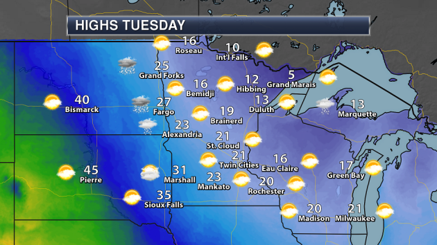
We’ll see considerably colder temperatures behind the Arctic front Tuesday, with highs barely making it into the 20s across parts of southern Minnesota. Many areas of northern Minnesota won’t make it out of the teens, and will only be in the middle single digits for Grand Marais.
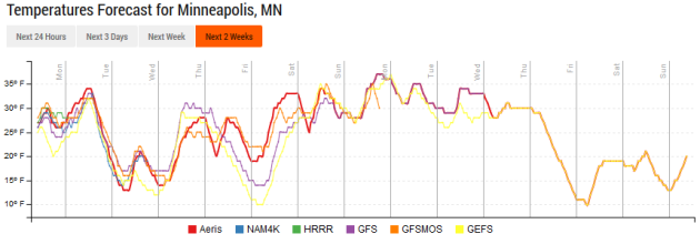
You can see that dip in the temperatures for Tuesday behind the front, but we do see them rebounding by Wednesday. We could see highs back in the 30s by the weekend and into early next week.
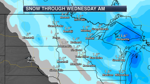
The clipper that moves through the state Sunday night into Monday will bring the potential of 1-2″ for many areas, especially from around I-94 north and east.
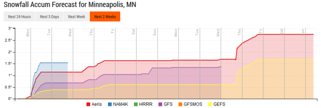
No big snowfall events continue to be in the forecast over the next couple weeks in the Twin Cities. After our inch to two of snow to start Monday off, a few snow showers or flurries will be possible Wednesday through Friday, with not much accumulation expected. Long range shows another snow chance next weekend and toward the middle of next week – but again, they don’t look to be massive snow producers. Will we have a white Christmas? We shall see.
_______________________________________________
National Weather Stories
A clipper system will bring snow to parts of the upper Midwest and Great Lakes. Otherwise, most of the rest of the country is expected to be quiet as we head through Monday.
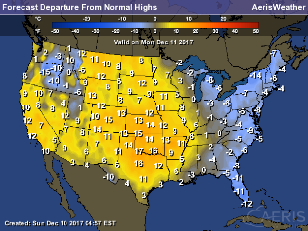
Many areas from the Mississippi River westward will see above average temperatures Monday (expect for the Intermountain West). The east coast will see below average temperatures.
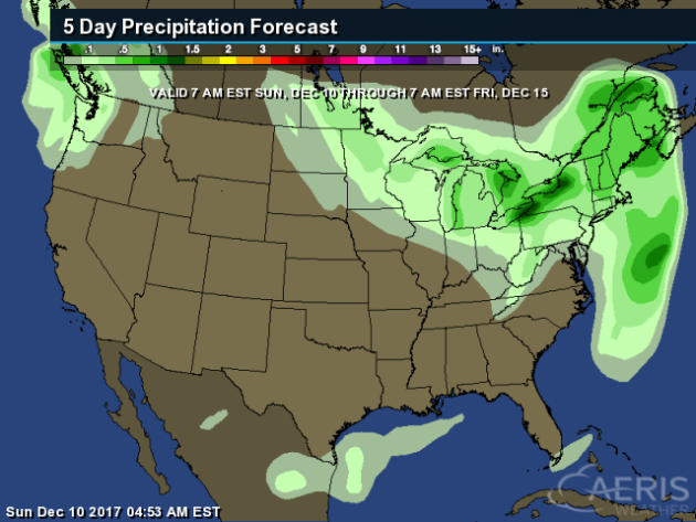
The heaviest precipitation over the next five days will be along the eastern Great Lakes due to lake effect snow. A few clippers/light snow events will affect parts of the northern Plains into the Northeast, with rain closer to the coast. After fairly dry conditions recently in the Northwest, a system will move in toward the end of the week.
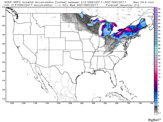
The heaviest snow through Tuesday evening will be around the Great Lakes, with the potential of 6-12″+ in spots. Heavy snow amounts of 4-7″ will also be possible Tuesday across parts of New England.
_______________________________________________
Snow So Far This Winter
Looks like winter skipped right over parts of the central of the county, with that stripe of snow that fell Thursday Night into Saturday from Texas across parts of the Southeast and Mid-Atlantic. Birmingham, AL recorded 4″ of snow from this system, more than areas like Chicago (0.7″), Minneapolis (3.1″), Detroit (2.1), and Des Moines (Trace) have received so far this winter.
“Well-Behaved” Snow In Washington D.C.
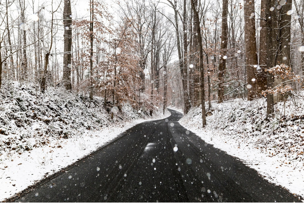
A correct snow forecast… for many meteorologists, that is the hope every time it snows. Looks like they were right on target in the D.C. area Saturday. More from the Capital Weather Gang: “The Washington area and forecasters passed their first snow test of the winter. Amounts were in line with what was predicted. Meanwhile, the snow mostly didn’t stick to roads – minimizing disruptions around the region. It also helped the snow fell gently on a Saturday, while schools were out and most Federal workers off. The region’s first measurable snow fell right on time. The average date of the D.C. area’s first accumulating snowfall is between Dec. 10 and 15. Even so, it was the first accumulating snowfall in D.C. during Dec. since 2013.” (Image: Snow, Dec. 9. (Jarrett Hendrix via Flickr))
More Severe Droughts Coming In California?

More severe droughts are possible in California due to melting ice. More from Reuters: “Melting Arctic sea ice could render sun-soaked California vulnerable to a recurrence of the severe drought suffered in recent years as it is likely to cause high pressure systems that push away rain-bearing storms, a study released on Tuesday said. As temperatures rise, the Arctic Ocean is expected to become ice-free within two or three decades, resulting in more of the sun’s heat being stored in the Arctic Ocean, leading to atmospheric circulation changes and cloud formations in the tropical Pacific that move north.” (Image: The crew of the U.S. Coast Guard Cutter Healy, in the midst of their ICESCAPE mission, retrieves supplies in the Arctic Ocean in this July 12, 2011 NASA handout photo. Kathryn Hansen/NASA via REUTERS/File Photo)
________________________________________________
Thanks for checking in and have a great Monday! Don’t forget to follow me on Twitter (@dkayserwx) and like me on Facebook (Meteorologist D.J. Kayser)!
– D.J. Kayser

