Dangerously Cold Wind Chills
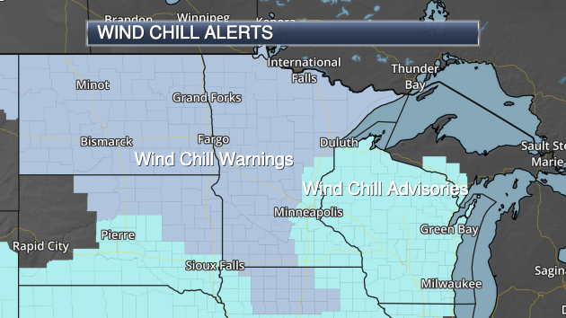
Wind Chill Advisories have been issued for Friday Night through midday Sunday in the Twin Cities as wind chill values are expected to be consistently between -20 and -35, even with “warmer” daytime temperatures in the single digits below zero. Across central Minnesota, Wind Chill Warnings have been issued from Friday Night through Sunday morning for wind chill values between -25 and -40. In parts of northern Minnesota, Wind Chill Warnings are in effect through Monday morning.
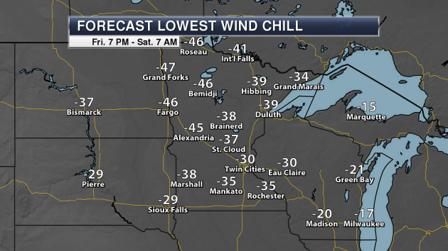
Wind chills Friday Night are expected to approach -30 in the Twin Cities, with most of central and northern Minnesota seeing wind chills in the -30s and -40s. These types of wind chills can easily produce frostbite in a short period of time.
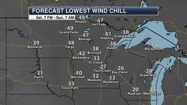
We will also see bitterly cold wind chills to start Sunday as well, with another round of -20s, -30s and -40s across much of the state. Wind chills may be even colder across parts of northern Minnesota into the Fargo and Grand Forks areas Saturday Night vs. Friday Night.
_______________________________________________
Cold New Year’s Day 2018 Ahead
They say one is the loneliest number… but that will be our high to begin 2018 in the Twin Cities. One degree for the first day… kind of fitting, right? Across the state temperatures will be within a few degrees (plus or minus) of zero to bring in the New Year, with mostly sunny skies expected.
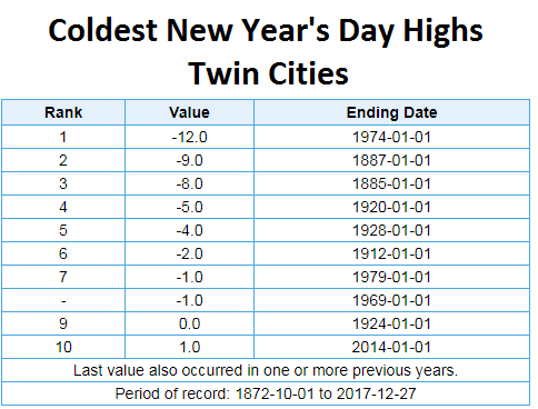
While we could see a top ten coldest New Year’s Day in the Twin Cities Monday, highs won’t luckily be close to the coldest New Year’s on record. That was set in 1974 when the high only reached -12.
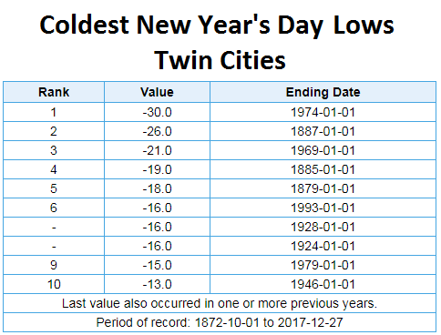
We could also see a low New Year’s Day morning that will be close to breaking into the top ten, but will be far short of the record low for the day of -30 also set in 1974.
_______________________________________________
Fun With Negative Numbers – Coldest of the Winter?
By Paul Douglas
Does aerobic shivering count as exercise? Note to self: keep moving. It’s only cold when you’re standing still.
Yes, I’ll whine about the polar pain while staring out my dual-pane Marvin windows, clad in a sturdy Thinsulate jacket, before remote-starting my car and turning my heated car seats onto HIGH.
The pioneers who settled Fort Snelling in the 1830s had no warm weather creature comforts to speak of. They dressed in layers, cuddled up and waited patiently for spring to arrive.
The battery-draining airmass oozing overhead may be the coldest of the entire winter. Weekend temperatures won’t rise above 0F; in fact New Year’s Eve may be the coldest since 1973 in the Twin Cities. The windchill dips to -30F at times today; check in on older friends and family members. Hypothermia poses the greatest risk to the elderly.
Teens will feel tolerable next week; a Pacific flow luring the mercury into the 20s and 30s the second week of January. I don’t see any significant snow looking out 2 weeks. Maybe the pattern will shift by February 4. I mean what can possibly go wrong, weatherwise?
_______________________________________________
Extended Twin Cities Forecast
SATURDAY: Bitter. Feels like -30F. High -4. Low -14. Chance of precipitation 10%. Wind NW 8-13 mph.
SUNDAY: Tastes like Polar Vortex. Still numb. High -3. Low -16. Chance of precipitation 10%. Wind NW 7-12 mph.
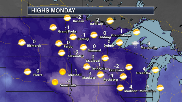
MONDAY: Polar. At least the sun is out. High 3. Low -5. Chance of precipitation 10%. Wind W 5-10 mph.
TUESDAY: Clouds increase, not as harsh. High 17. Low 2. Chance of precipitation 20%. Wind SW 10-20 mph.
WEDNESDAY: Another shot. Blue sky. High 8. Low -5. Chance of precipitation 10%. Wind NW 8-13 mph.
THURSDAY: Patchy clouds, few flurries. High 15. Low -8. Chance of precipitation 30%. Wind S 5-10 mph.
FRIDAY: Intervals of sun, cold & quiet. High 9. Low -4. Chance of precipitation 20%. Wind NW 5-10 mph.
_______________________________________________
This Day in Weather History
December 30th
2005: A large swath of snowfall in the 6 to 8 inch range falls approximately north of a line from Madison to Redwood Falls through Glencoe and Woodbury. Even heavier snowfall occurred west of a Granite Falls to Willmar line, where reports of between 8 and 11 inches were recorded. In Willmar, several vehicles were reported stuck in ditches. A semi-truck also rolled onto its side.
1996: 6 to 7 inches of snow falls in Willmar. The new snowfall, in addition to previous heavy snowfall, caused a portion of the historical society’s roof to collapse.
1980: A ‘heat wave’ develops across Minnesota. Redwood Falls hits 51.
_______________________________________________
Average Temperatures & Precipitation for Minneapolis
December 30th
Average High: 24F (Record: 51F set in 2004)
Average Low: 9F (Record: -20F set in 1973)
Average Precipitation: 0.04″ (Record: 0.39″ set in 1884)
Average Snow: 0.3″ (Record: 4.0″ set in 1906)
_______________________________________________
Sunrise/Sunset Times for Minneapolis
December 30th
Sunrise: 7:51 AM
Sunset: 4:40 PM
*Length Of Day: 8 hours, 49 minutes and 31 seconds
*Daylight Gained Since Yesterday: ~0 minutes and 41 seconds
*Latest Sunrise: December 30th-January 5th (7:51 AM)
*Next Sunset at/after 5 PM: January 17th (5:00 PM)
_______________________________________________
Minnesota Weather Outlook
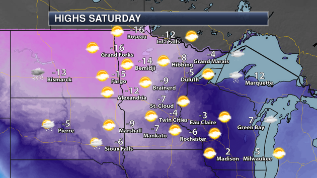
Ready to visit the freezer section of the weather department again? Highs won’t make it above zero across most – if not all – of the state Saturday, with highs in the single digits and teens below zero.
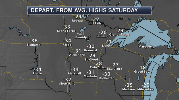
If that map was hard to look at… this might be worse. Highs will be 20-35 degrees below average for this time of year Saturday. Find the heavy parka if heading out… or better yet, just stay inside. It might be better for your sanity.
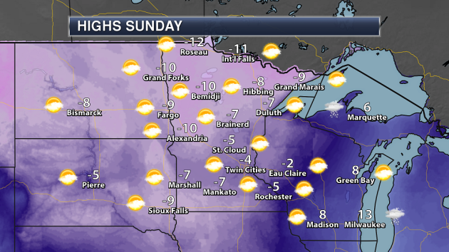
We are expected to see temperatures below zero throughout the entire weekend across the state, with -4 expected for a high Sunday in the Twin Cities.
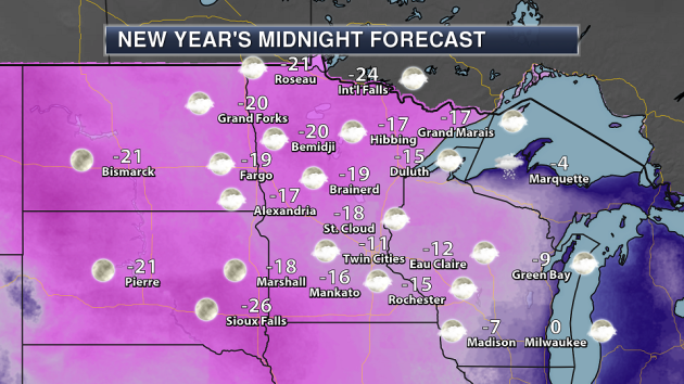
And if you are heading out for New Year’s Eve festivities across the state Sunday night… the only words I can say to you is “bundle up!” By midnight, we’ll see temperature in the 10s and 20s below zero with partly cloudy skies.
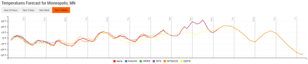
The good news is that highs next week should be above zero… so there’s that. Unfortunately, they’ll only be in the single digits and teens until potentially late next weekend. Florida sounds good right about now…
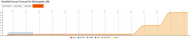
Snow chances are minimal through the first week of the new year, with maybe only a slight chance of snow next Thursday across the region. We might see better snow chance into the second week of the month if the long range models are correct, though.
_______________________________________________
National Weather Outlook
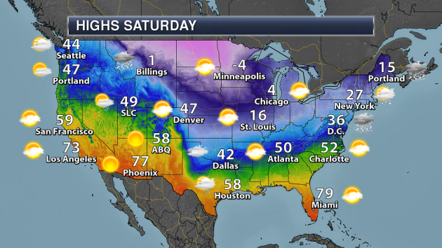
Heavy lake effect snow will be underway across portions of the Great Lakes Saturday behind a clipper-like system moving through the Northeast. Some rain and snow will continue across the Northwest. Meanwhile, the other story will be the bitterly cold air setting into portions of the nation, with the Twin Cities expected to see a below zero high.
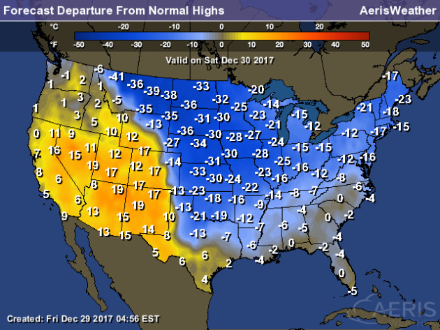
Canada has decided to share the cold air just in time for the year to end, as temperatures from Montana to parts of the southern Plains will be 20-40 degrees below average Saturday. We’ll also see highs that are 10-20 degrees below average across the Northeast. Warmer than average weather can be found across the Southwest for the second to last day of 2017.
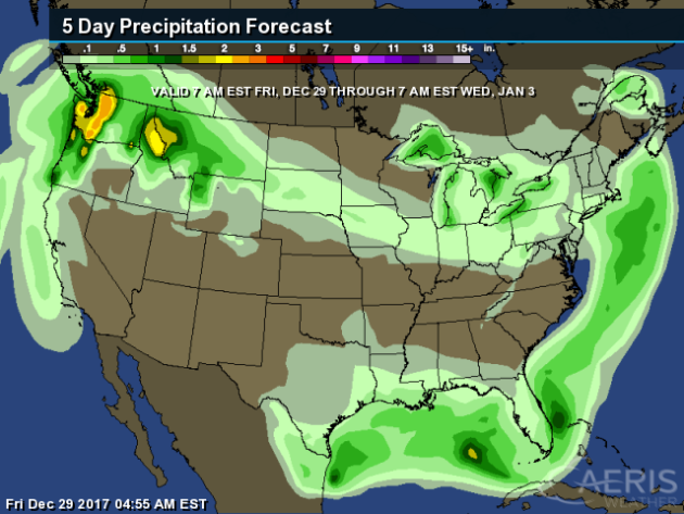
The heaviest precipitation across the nation over the next five days will be across the Northwest, where a few inches of liquid may fall by Saturday morning.
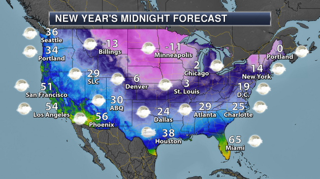
Taking a look nationwide at the forecast for midnight Sunday night as we turn the page from 2017 to 2018… there’s a good portion of the nation that will want a heavy coat. If you are looking for warm weather to celebrate the new year, there’s still time to book a ticket to the Bay Area, Phoenix or Miami! For the ball drop in New York City, we’ll see temperatures in the mid teens at midnight.
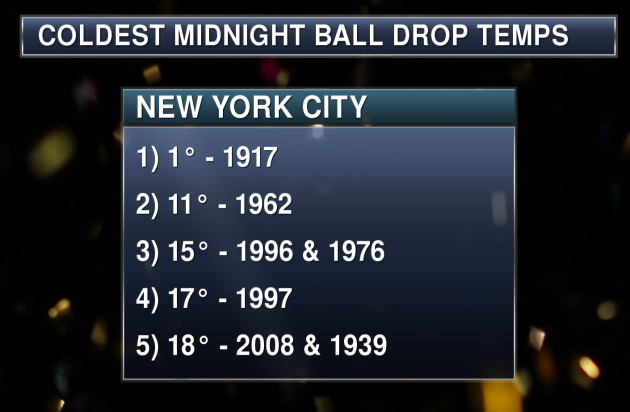
If we saw that temperature of 14° in New York City at midnight Sunday Night, it would be the third coldest ball drop in Central Park observation history (going back to 1907).
_______________________________________________
50th Anniversary Of The Ice Bowl
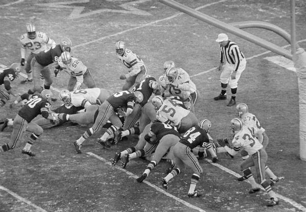
Sunday marks the 50th anniversary of the Ice Bowl at Lambeau Field. NWS Green Bay has more: “The 1967 NFL Championship Game between the Dallas Cowboys and the Green Bay Packers, played on December 31 at Lambeau Field, is known as the Ice Bowl, arguably one of the greatest games in NFL history. The game was played in brutal cold and windy conditions. The kickoff temperature in Green Bay was -13°F, with a wind chill of 36 below zero. Temperatures were so cold, in fact, that referees had to shout signals so that the metal whistles wouldn’t stick to their lips. Even so, nearly 51,000 fans watched the coldest game in league annals.” (Image: Green Bay Packers quarterback Bart Starr scores the game-winning touchdown against the Dallas Cowboys in the NFL Championship Game on Dec. 31, 1967, at Lambeau Field in Green Bay. (AP Photo))
The Response For Cold Weather Climate Change Deniers
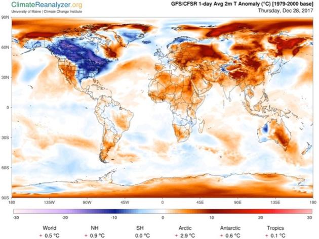
When it gets cold, do you ever hear people say “so much for global warming?” Professor of meteorology at the University of Georgia Marshall Shepherd has the response he uses when people say that over at Forbes: “If you are reading or watching the news, winter weather is the current headline. Negative wind chills, feet of lake effect snow in the Great Lakes region, and possibly the coldest New Year’s Eve ball drop in almost a half century are on tap. Forecasts are suggesting that temperatures will be in the teens and wind chills below 0 deg F as the famed ball descends from the New York City skyline. The top 3 coldest temperatures were: 1 degree F in 1917, 11 degrees in 1962, and 15 degrees in 1976/1996, respectively. Like clockwork, you will also start seeing tweets and posts refuting climate change even though 2017 will end as one of the top 3 warmest years on record. It is very common to see statements like”those climate scientists are full of it, I have 30 inches of global warming in my yard.” These moments are perfect opportunities to increase science literacy. Here is a template for how I often explain cold weather within the context of a warming climate.” (Image: Near surface temperatures on December 28th as generated by the Climate Reanalyzer online software tool)
________________________________________________
Thanks for checking in and have a great Saturday! Don’t forget to follow me on Twitter (@dkayserwx) and like me on Facebook (Meteorologist D.J. Kayser)!
– D.J. Kayser

