34 F. high yesterday in the Twin Cities.
32 F. average high on February 25.
35 F. Maximum temperature in the MSP metro on February 25, 2016.
February 26, 1996: A bolt of lightning from a snowstorm causes an explosion at a fireworks storage site in Milaca. One employee was injured and several homes in the area were damaged. An eight foot crater was all that remained where the storage site had been.
February 26, 1971: Extremely low pressure moves across Minnesota. The Twin Cities had a barometer reading of 28.77 inches and Duluth beat that with 28.75. Freezing rain and snow hit northern Minnesota, dumping up to 18 inches of snow in some areas. Areas around Virginia, MN were without power for 5 days.
February 26, 1896: A balmy high of 60 degrees is reported at Maple Plain. The warm weather hampered the annual ice cutting on Lake Independence to store for summer use.
Limping Into Spring A Little Early This Year
“Joy is not produced because others praise you. Joy emanates unbidden and unforced. Joy comes as a gift when you least expect it. At those fleeting moments you know why you were put here and what truth you serve” writes David Brooks in his remarkable book “The Road to Character”.
What brings you joy? Your faith? Kids? Grandkids? All of the above. Yesterday it was the sun waking me up, not the shrieking of an alarm clock.
We’ve picked up well over 2 hours of daylight since December 1. A higher sun angle and nagging lack of snow cover means the sun’s energy can go into heating up the air, not melting snow. The result will be 40s by Monday; even a little rain Tuesday. ECMWF guidance hints at 50s next Saturday.
We’ll see more cold fronts (there’s a bold prediction) but the odds of sustained, subzero weather are small, and receding fast with each passing day.
Yesterday my sister called me about a tornado warning west of Philadelphia. The east has experienced record-crushing highs in the 70s and 80s; the warmest temperatures ever observed in February.
Gloriously unsettling.
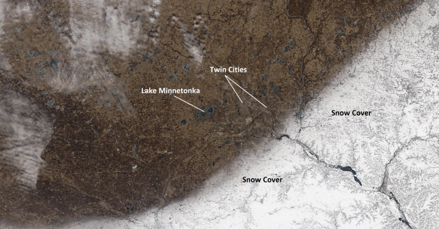
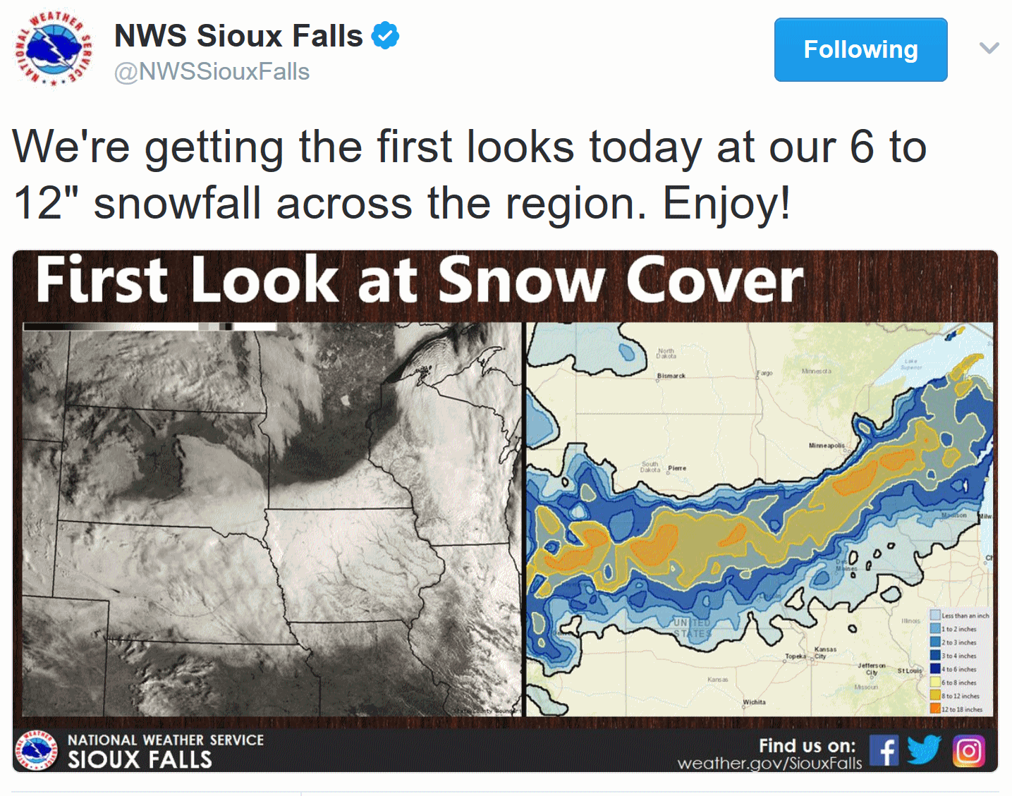
Close Call. Here is Saturday’s high-resolution (10 meter) image of Minnesota and western Wisconsin from CIMSS/SSEC at The University of Wisconsin, showing just how close the snow came to the Twin Cities.
Mea Culpa From the National Weather Service. Trust me, meteorologists are upset when they (we) miss a forecast, and this was a big bust, no question. But people expect perfection in a very imperfect world. And it almost seemed to me like some people were venting their frustration about another snow-less winter. I like snow – I would have been thrilled with another foot of the white stuff, but it just wasn’t meant to be. Patch has a transcript of a post that went out Friday night: “We understand your frustration with the changing forecasts as this system evolved. We realize many people made or changed plans based on our forecasts,” the NWS said. “We sympathize with those of you out there who are disappointed with the initial forecasts that didn’t work out.” The service also said it would “evaluate” its messaging and forecasts from this week. Patch has reproduced the letter, in full, below:
Dear Minnesota and Wisconsin Residents,
We would like to take a couple minutes to address the latest winter storm to affect our area, and also provide our thoughts on the changes to the forecast the past couple days.
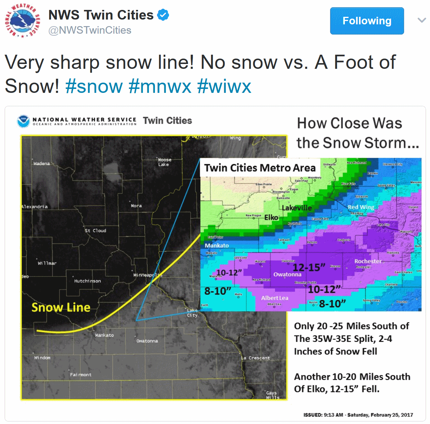
For over a week, the weather models we depend on have been forecasting a significant winter storm across a large portion of the Upper Midwest, including most of central/southern MN and western WI.
Nearly all the weather models we use showed a 10 to 20 inch area of snow across the southern half of Minnesota and in western Wisconsin at one time or another. The precise location of this snow band was not certain, but our recognition of the incoming weather pattern and the weather models all pointed to a significant snowfall event for today. Even as late as Wednesday-Thursday, there were still weather models showing the heaviest snow band farther north with heavy snow impacting the Twin Cities metro area.
Our forecasts on Monday, Tuesday and Wednesday depicted a middle-of-the-road solution in terms of location.
By Thursday, it was apparent that the vast majority of the heavy snow would impact northern Iowa, far southern Minnesota and western Wisconsin. By Thursday, we used radar, satellite and weather models with higher detail to see how the snow bands were taking shape, and ultimately where the storm was tracking. In the end, the heavy snow continues to fall 50-100 miles to the southeast of where earlier forecasts were calling for heavy snow. There is also a remarkably small transition zone from heavy snow to absolutely zero snowfall. These are quite difficult to pin down even hours before the snow begins.
We understand your frustration with the changing forecasts as this system evolved. We realize many people made or changed plans based on our forecasts. We sympathize with those of you out there who are disappointed with the initial forecasts that didn’t work out.
We promise to evaluate our messaging and forecasts this week, and continually work to provide you with the best information we possibly can.
Our thoughts are also with the folks of southern MN and western WI, who continue to see heavy snow today and are trying to dig out from the 8-14” of snow that are already on the ground. We would like to thank our local and national media that helped get the winter storm message out. We would like to thank all of the many local, state and federal partners we have worked with this week and continue to work with today. These are the folks making the tough decisions based on the forecasts — and who are always striving to keep the people of Minnesota and Wisconsin safe.
Thank you to everyone else for your continued support and for following us. Good luck to those dealing with the storm today. We remain committed to providing the most accurate information we can for the rest of the winter and as we head into flooding/severe weather season this spring.
Sincerely,
The Forecast Team
National Weather Service Twin Cities
Record-Setting Warm Spell. The duration and intensity of warmth in Minnesota in February was unique and unprecedented in the historical record. Dr. Mark Seeley has more details on February’s amazing warmth in this week’s edition of Minnesota WeatherTalk: “…Two new preliminary statewide maximum temperature records were reported during this warm spell: 67°F at Redwood Falls on the 17th is a new statewide record for the date; and 66°F at Amboy reported on the 22nd is a new statewide record high for the date as well. In addition, some new high record dew point values were reported during this spell of warmth, including a reading of 52°F at MSP on Monday, February 20th which also tied for the highest ever dew point measured in the Twin Cities during the month of February (also occurred on February 25, 2000). Another noteworthy feature in Minnesota’s climate was what happened in Voyageurs National Park. Like the warm spell in mid-Jsnuary last month, the warm spell this month forced the closure of the ice roads on Rainy Lake and Kabetogama. To the best of my knowledge this is the first time these ice roads have been closed in back to back winter months…”
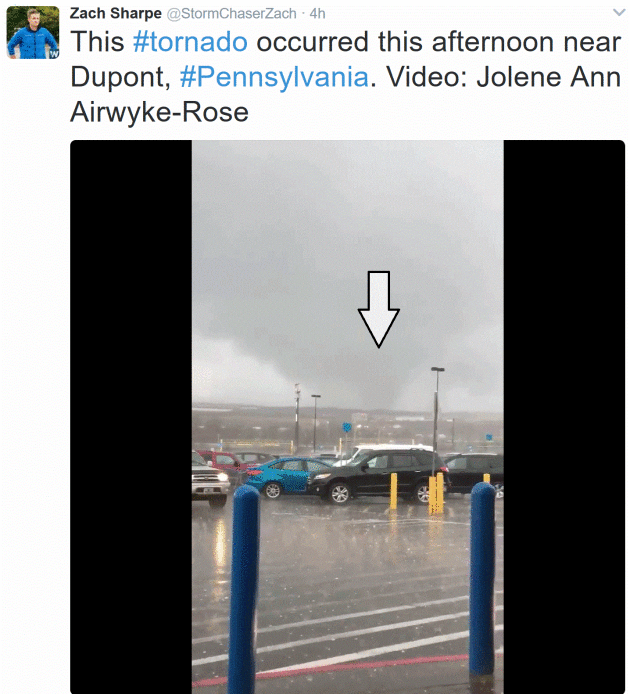
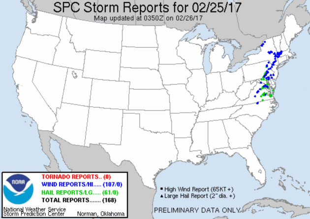
Saturday Storm Reports. NOAA SPC was reporting 107 severe wind reports (capable of damage) and 61 large hail reports as of late last night – I’m pretty sure a few confirmed tornado reports will be added to the list.
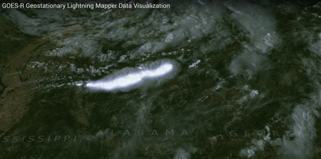
Tracking Lightning From Space. The GOES-16 GLM, or Geostationary Lightning Mapper should become operational later this year with a potential to revolutionize severe weather forecasting and tracking – providing a continuous stream of cloud to cloud and cloud to ground lightning, which often spikes before a major outbreak of severe storms or tornadoes. More details via NOAA/NASA: “GLM will collect information such as the frequency, location and extent of lightning discharges to identify intensifying thunderstorms and tropical cyclones. Trends in total lightning that will be available with the GLM have the promise of
providing critical information to forecasters which will allow them to focus on developing severe storms much earlier than they can currently, and before these storms produce damaging winds, hail or even tornadoes.
Such storms exhibit a significant increase in total lightning activity, often many minutes before the radar detects the potential for severe weather. Used in combination with radar, satellite data, and surface observations, total lightning data from GLM has great potential to increase lead time for severe thunderstorm and tornado warnings and reduce false alarm rates.Knowledge of total lightning activity and its extent will help improve public safety...”
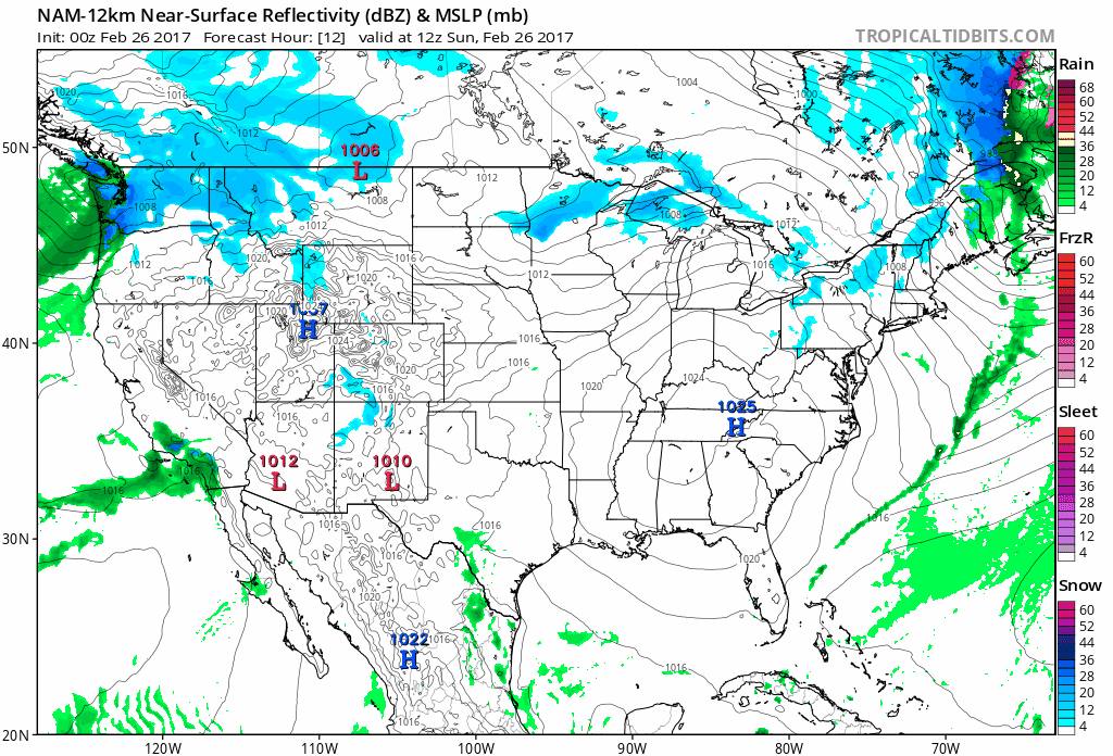
Fast-Forward Spring. There’s a little blue (snow) on future radar, but not as much as one would expect in late February. The cold front that spawned Saturday’s surreal severe weather outbreak across the northeastern USA yesterday is sailing out to sea as temperatures cool off today. The southeast enjoys cool sun before a return of showers and T-showers by midweek. The Pacific Northwest gets pelted with more wind-whipped rain and snow for the elevations, spreading into northern California tonight and Monday. 84-hour NAM guidance: NOAA and Tropicaltidbits.com.
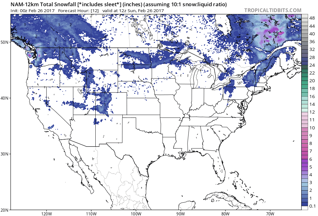
Accumulating Snow Potential. The Colorado Rockies may pick up over a foot of additional snow by Wednesday morning; generally nuisance amounts of snow for the northern USA into New England – more typical of mid-March.
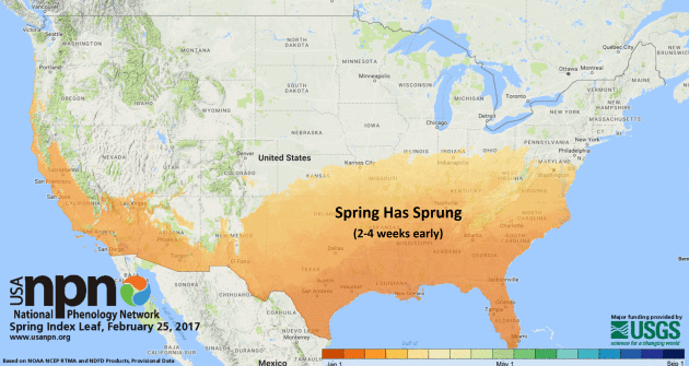
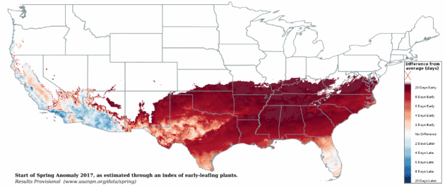
The U.S. Geological Survey Hails an Early Spring – And Ties It To Climate Change. The Washington Post reports: “As the nation basks in some of the warmest February weather it has seen in decades, the U.S. Geological Survey has been quick to point out that the early spring conditions are another symptom of climate change. On Thursday, the USGS shared a new analysis just released by the USA-National Phenology Network, which the agency helps to fund, showing that an early spring has already swept through the Southeast and is continuing to work its way across the country. As the agency points out, the new analysis reaffirms a fact scientists have known for at least a decade now — that “climate change is variably advancing the onset of spring across the United States.” The analysis relies on a special “spring index,” which defines the start of spring as the point when temperatures allow for certain early-season events in plants, such as the emergence of leaves and blooms...”
Map credit: “How do you know when spring has begun? Is it the appearance of the first tiny leaves on the trees, or the first crocus plants peeping through the snow? The Spring Leaf Index is a synthetic measure of these early season events in plants, based on recent temperature conditions. This model allows us to track the progression of spring onset across the country. The map (above) shows locations that have reached the requirements for the Spring Leaf Index model (based on NOAA National Centers for Environmental Prediction Real-Time Mesoscale Analysis temperature products).”
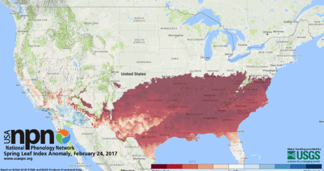
An Alarmingly Early Spring is Sweeping Across the Southern United States. Here’s a clip from Gizmodo: “Spring is well ahead of schedule across much of the southern United States, in some cases by at least two to three weeks. An early spring may sound nice, but it comes with serious consequences—both to human health and the environment. A new set of maps produced by the USGS-led US National Phenology Network (US-NPN) demonstrates just how ahead of schedule spring is across much of the continental United States. Temperature-sensitive plants have started to become active earlier than normal, sprouting leaves and flowers in coastal California and southern Nevada through to the southern Great Plains and the Atlantic Coast. In Washington, DC, spring arrived 22 days earlier than historical norms, as indicated by data on leaf-outs and flowering...”
Map credit: “An anomaly map showing the degree to which early spring has appeared in the US. In Washington DC, spring arrived 22 days earlier than normal.” (Image: US-NPN).
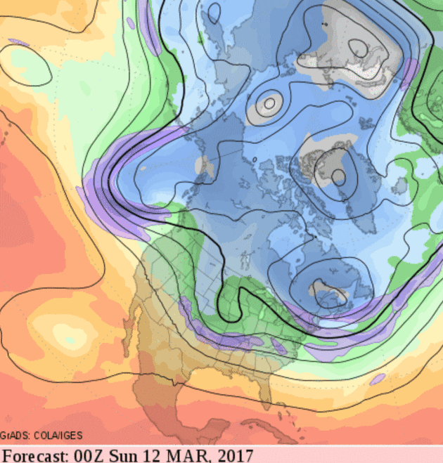
Minor Winter Relapses Northern USA. It’s still a very active pattern as we transition into what may turn into a weak El Nino pattern (again) with the coldest weather aimed at New England; most of the nation still trending milder than average for mid-March.
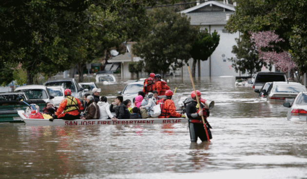
San Jose Flood Photos: Dramatic Images of This Week’s Disaster. The Mercury News in the Bay Area has a photo essay that puts this week’s historic flooding of San Jose into stark perspective: “Here are dramatic images of the flooding in San Jose neighborhoods following heavy rains on President’s Day weekend. The flooding, the worst the city has seen in decades, prompted the frantic evacuation of 14,000 people.”
Photo credit: “San Jose Fire Department rescuers evacuate the last residents from their homes along the flooded streets on Welch Ave and Needles Drive near Kelley Park in San Jose, Calif. on Tuesday, Feb. 21, 2017.”
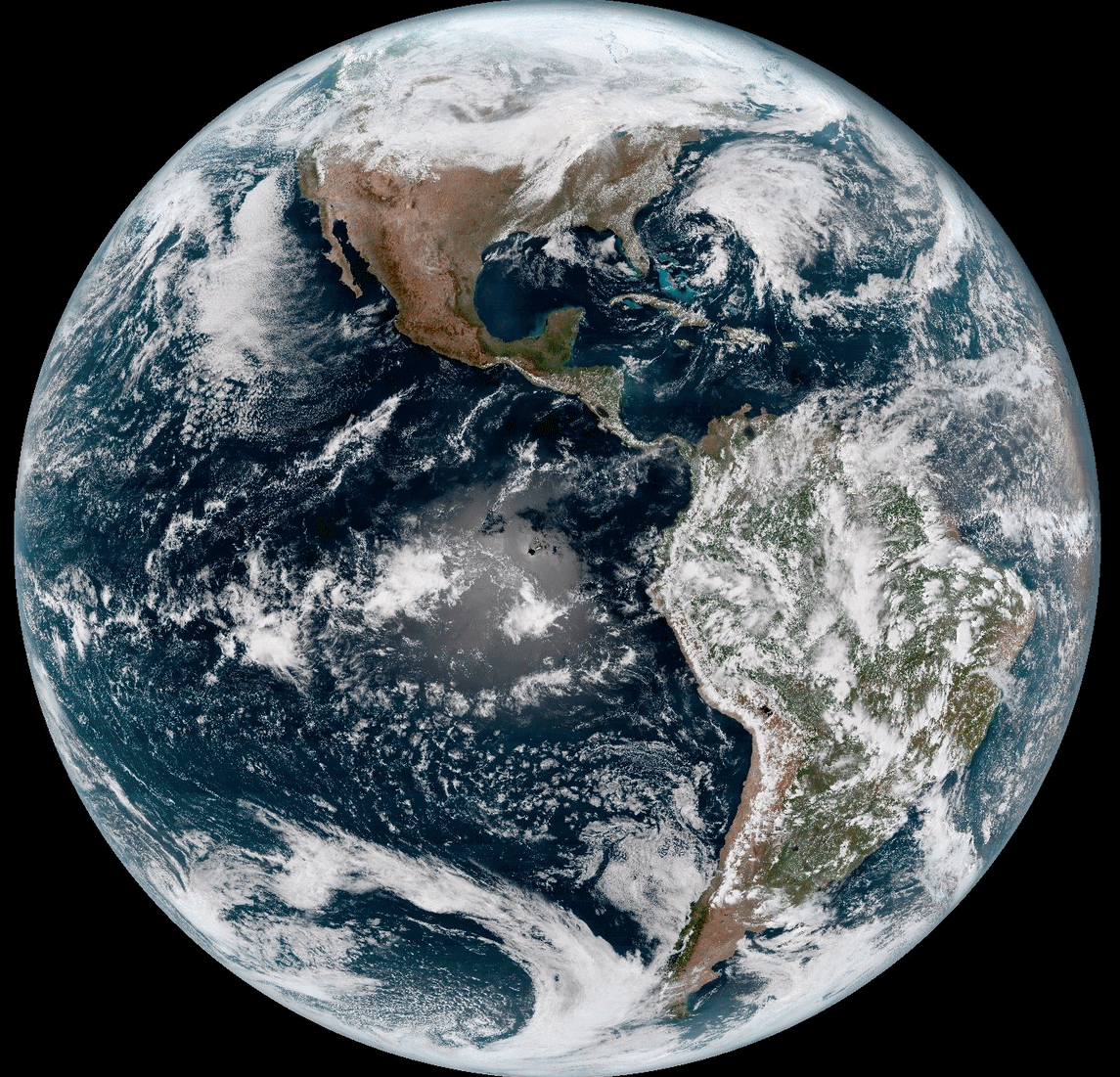
February 24 full-disk image above courtesy of GOES-16 and NOAA. Check out NOAA’s GOES-16 Image Gallery for more eye-popping imagery.
Alabama’s Newest Climatologist Has a Heads-Up for Gulf Coast. Here’s an excerpt from AL.com: “…If the floating ice is melting, that could remove the inward pressure against continental glaciers the shelves help to maintain. That could lead to more continental ice flowing into the sea. “So we could have runaway scenarios where you’re contributing a lot of ice to the global ocean and increasing sea level significantly,” Minzoni said. As a paleoclimatologist, Minzoni can discuss climate change going back thousands of years. She knows the old patterns and the recent trends. She knows these discussions can get political these days, but she finds most people simply curious. “I think they like it when you’re able to explain the data, explain why we have these conclusions we’ve made about climate change and what data we’re adding to better predict future climate change,” she said. “Even though politicians try to paint it as black and white, it’s not black and white,” Minzoni said. “There’s a lot of shades of gray. It’s actually pretty fun to get into the weeds and understand what these key processes are that affect climate and how we can build better records and better models to predict future change...”
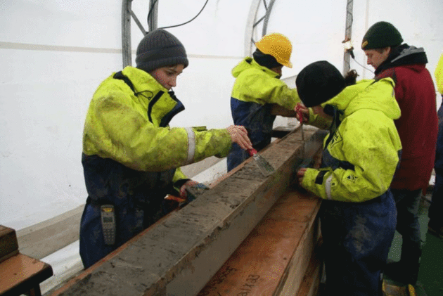
Photo credit: “University of Alabama climatologist Dr. Rebecca Minzoni, left, is shown during a scientific expedition to Antartic early in her career. Minzoni has helped identify underwater currents that are melting Antarctic glaciers from underneath.”
Air Pollution Affects Preterm Birthrates Globally, Study Finds. Here’s an excerpt from The Washington Post: “A pregnant woman’s exposure to air pollution has adverse effects on her fetus, according to a new international study, with prolonged exposure associated with nearly 1 in 5 premature births globally. The study, published recently in the journal Environment International, is the first global estimate of preterm births associated with pollution caused by fine particulate matter. This matter, known as PM2.5, is identified by the size of the microscopic particles and droplets it contains (2.5 micrometers in diameter or less), and it can reach deep into the respiratory tract. It is emitted by man-made sources such as diesel engines, industrial plants and the cooking fuels used mostly in parts of Asia, as well as by natural sources such as chemical reactions occurring in the atmosphere...”
Photo credit: Paul Pival, Flickr.

The Future of Energy – Opportunities and Challenges. It turns out the new CEO of ExxonMobil supports the Paris Climate Accord; here’s an excerpt of a recent post: “…Most forecasts project that many factors – including global population growth of nearly 2 billion, a doubling of worldwide economic output and a rapid expansion of the middle class in emerging economies – will raise global energy demand by an amount equivalent to the total energy used today in the entire Western Hemisphere. This growing demand creates a dual challenge: providing energy to meet people’s needs while managing the risks of climate change. I believe, and my company believes, that climate risks warrant action and it’s going to take all of us – business, governments and consumers – to make meaningful progress. At ExxonMobil, we’re encouraged that the pledges made at last year’s Paris Accord create an effective framework for all countries to address rising emissions; in fact, our company forecasts carbon reductions consistent with the results of the Paris accord commitments...”
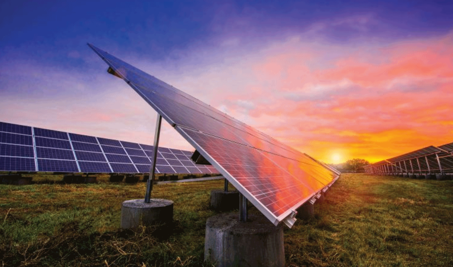
Xcel Energy Switches on 32 MW of Community Solar in Minnesota. I don’t take for granted the fact we have a utility that gets it, and is trying to get out in front of the renewable energy revolution. Here’s an excerpt from PV-Tech: “Xcel Energy has commissioned seven new community solar gardens, totalling 32MW in Minnesota. The projects were developed under the utility’s Solar Rewards Community programme that aims to spur community solar among residential subscribers and local businesses. Xcel Energy currently has 57MW of community solar gardens online at 17 project sites as part of its programme, which was launched in 2014. The projects are also part of a larger 96MW of community solar to be developed by BHE Renewables and Geronimo Energy that will provide clean energy throughout the Twin Cities metro area and greater Minnesota…”
Photo credit: “More community solar comes online in Minnesota, with seven new projects by Xcel Energy, Geronimo Energy and BHE Renewables.” Source: Xcel Energy.


Megyn Kelly, Matt Lauer, and the Battle for the Future of NBC. Vanity Fair has an article that will appeal to TV news geeks; here’s an excerpt: “…Aside from the executives at NBC and NBC News, according to two people familiar with the discussions, there was only one on-air personality who knew about Kelly’s wooing well in advance: Matt Lauer. (NBC denies this.) Coming from rightward-leaning Fox, Kelly might be seen as an effort by NBC to come to terms with life in a Donald Trump era. She is not overtly or inevitably a challenge to Lauer—perhaps she will prove a complement. More to the point, though, Kelly represents a literal doubling down on the proposition that, when it comes to a successful news operation, personality is what counts, and everything else must accommodate itself to that reality. How that will translate into what we see on TV remains to be seen, but one fact can’t be argued with: there used to be only one person at NBC News who was too big to fail. Now there are two.”

Listen Technology Holdouts: Enough is Enough. Having trouble finding parts for that 8-track player or 1997-era fax machine? The Washington Post feels your pain: “...But in some cases the devotion of the laggards can cause major headaches. When the market for outmoded products shrinks, most manufacturers just stop making them. By law, however, some technologies can’t be put to sleep until regulators give permission — usually long after the dying market has become unprofitable. Car manufacturers must keep up to a decade’s worth of spare parts, for example, even for discontinued models. And the U.S. Postal Service, teetering on bankruptcy for over a decade, still has to deliver mail to 155 million households, even as first-class volume continues to decline precipitously. As the post office has learned, the cost of keeping old technologies on life support skyrockets when expensive networks of equipment and people must be spread over a dwindling number of users…” (Photo credit: iStock).

Dubai to Test Passenger-Carrying Drones. Sign me up. Wait, not sure I want to beta-test this, but version 3.6? I’m your guy. Here’s a clip from The Economist: “AT TIMES it can feel like we are living in an episode of “Travel Futurama”. This week: flying drone taxis. Dubai, a city that sometimes seems to inhabit a time zone five years ahead of the rest of the planet, has embraced another improbable travel innovation, to go alongside its enthusiasm for hyperloop trains and long driverless metro lines. This week, the Emirati metropolis announced it is to test passenger-carrying drones in its skies by July. The unpiloted drone taxis won’t exactly replace the traditional earthbound sort, since they will be able to carry only one passenger, who together with luggage cannot weigh more than 100 kilograms (220 pounds). And it will have a range of just 50 kilometres (31 miles), or half an hour of flying time…”

Sorry, Nobody Wants Your Parents’ Stuff. Amen to that. Here’s an excerpt from TPT: “…This is an Ikea and Target generation. They live minimally, much more so than the boomers. They don’t have the emotional connection to things that earlier generations did,” she notes. “And they’re more mobile. So they don’t want a lot of heavy stuff dragging down a move across country for a new opportunity.” And you can pretty much forget about interesting your grown kids in the books that lined their grandparents’ shelves for decades. If you’re lucky, you might find buyers for some books by throwing a garage sale or you could offer to donate them to your public library — if the books are in good condition. Most antiques dealers (if you can even find one!) and auction houses have little appetite for your parents’ stuff, either. That’s because their customers generally aren’t interested…”

Costco Giving Up on Winter. I couldn’t help but notice all the summer camping/swimming/lake stuff on full display at my local Costco store. Another sign of the times…

TODAY: Clouds, flakes north. Winds: W 10-15. High: 37
SUNDAY NIGHT: Partly cloudy. Low: 23
MONDAY: Patchy clouds, turning milder again. Winds: S 10-15. High: 45
TUESDAY: Light rain and drizzle. Winds: NE 8-13. Wake-up: 33. High: 41
WEDNESDAY: Mostly cloudy, drier and cooler. Winds: N 10-15. Wake-up: 28. High: 36
THURSDAY: Chilly, few passing flurries. Winds: NW 8-13. Wake-up: 23. High: 32
FRIDAY: Sunny, milder breeze by afternoon. Winds: S 8-13. Wake-up: 18. High: 39
SATURDAY: Partly sunny, hints of April. Winds: SW 10-15. Wake-up: 30. High: 51
Climate Stories….
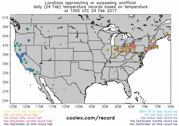
Is It Okay To Enjoy the Warm Winters of Climate Change? No, it probably shouldn’t be in the 60s and 70s in February, but should I feel guity for enjoying early pangs of spring fever? Here’s an excerpt from a timely article at The Atlantic: “…For the climate-concerned, this is an encouraging theory of change—and it fits with a body of research that suggests people experiencing unusual warmth are more likely to tell pollsters they believe in global warming. But a study published last year in Nature should make advocates pause. It found that, for the vast majority of Americans, the weather became more favorable and pleasant from 1974 to 2013. Over all, winters have gotten generally warmer and more pleasant for “virtually all Americans,” while summers have not yet become scorching and oppressively humid. This change has occurred on a shocking scale: On the “pleasantness index” used by the study, Boston in 2013 was as favorable as New York City was in 1976; and present-day St. Louis is nicer than D.C. or Baltimore four decades hence…”
Map credit: coolwx.com.

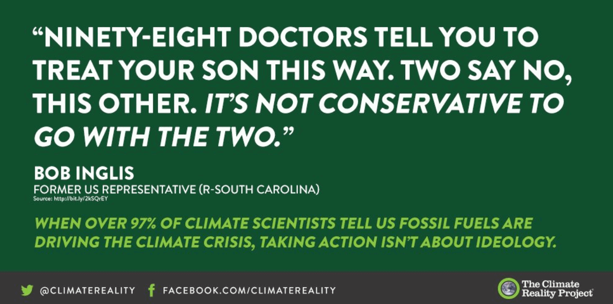
Conservative Group’s Carbon Plan Gives Us Hope for Climate Change Action. Here’s an excerpt of an Op-Ed from the Editorial Board at The Dallas Morning News: “…Congressional Republicans refuse to take powerful steps to embrace renewable energy. Like the Trump administration, they seem poised to roll back environmental rules, including the Obama-era Clean Power Plan, without also establishing a workable mechanism to reduce carbon emissions. With the clock ticking on climate change problems, this would be highly irresponsible. That is why we are pleased the Climate Leadership Council — a conservative panel including former Secretaries of State George Schultz and James Baker and former Treasury Secretary Henry Paulson — is challenging skeptics in their party with a market-based approach. While their plan to tax carbon emissions has flaws, as does any carbon reduction system, we think it boldly speaks truth to power and could bring moderate Republicans to the table...”
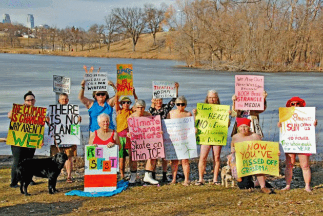
Minnesota Grandmas Get Naked To Draw Attention to Climate Change. Possibly my favorite headline ever. Here’s more from City Pages: “…During one of the recent 60 degree days, Gille and about a dozen friends decided they needed to remind everyone about our collective dire situation. The event was the brainchild of Minneapolis resident Polly Kellogg. They made signs and went to Powderhorn Lake. “Now you’ve pissed off grandma,” read Gille’s. “Climate change deniers skate on thin ice,” another said. Some of the women donned swimsuits. Others disrobed. Some more so than others. Gille was one of those who went topless for the cause. “Here we are having the warmest February days ever locally at the same time nationally we’re moving in the opposite direction as to the things we can do about global warming,” she says. “We had the [photo] shoot to let everyone know we’re not okay with it and neither should they.”
Photo credit: “Minneapolis grandmas bare all — or most — near Powderhorn Lake to bring attention to climate change, which has been delivering 60-degree days to our not-very-frozen tundra.”