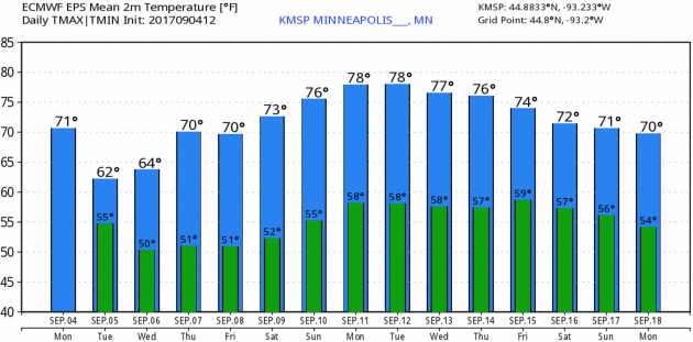
76 F. high yesterday in the Twin Cities.
76 F. average high on September 4.
79 F. maximum temperature on September 4, 2016.
September 5, 1990: Nine inches of rain falls in Duluth by the end of the following day, washing out $1,000,000 worth of roads.
September 5, 1982: 77 mph winds are reported in Anoka County.
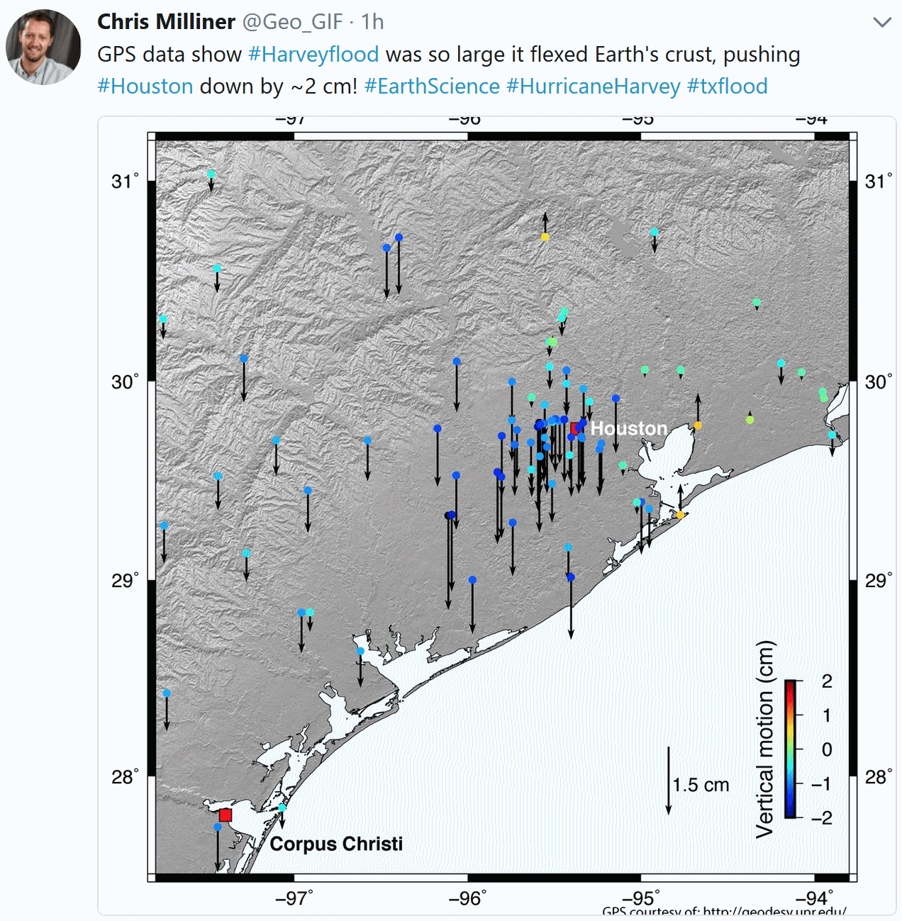
The biggest difference between Harvey and Irma? The tropical remains of Hurricane Harvey stalled over Texas for the better part of 5 days, unleashing a year’s worth of rain on Houston.
Canada leaks free A/C south of the border, with 60s for highs today and Wednesday. According to Mark Seeley August was the 11th wettest on record, statewide. I’m happy to report a dry week with a shot at 80 by Sunday.
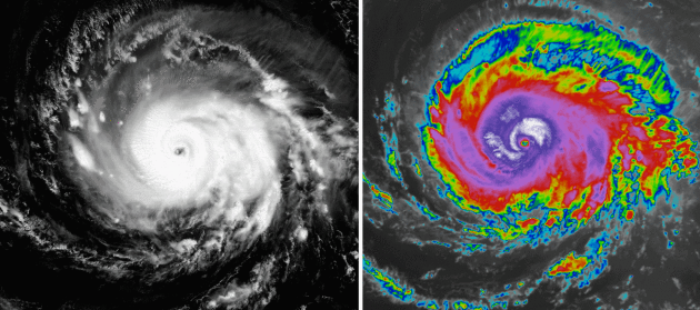
Symmetry. Non-operational GOES-16 images (visible and enhanced) taken midday Monday show a powerful hurricane with a double eye-wall and little sign of dry air or Saharan dust disrupting the feeder band circulation into the core of the storm. With Caribbean water temperatures unusually warm conditions favor additional strengthening in the coming days. Image: AerisWeather.
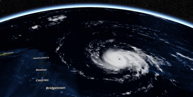
Perspective. This 3-D visible image perspective from midday Monday shows Puerto Rico on the far left side of the screen. Irma may come close enough to trigger significant storm surge and wind damage in San Juan. Image: AerisWeather.
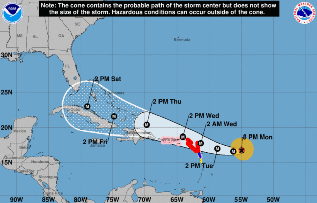
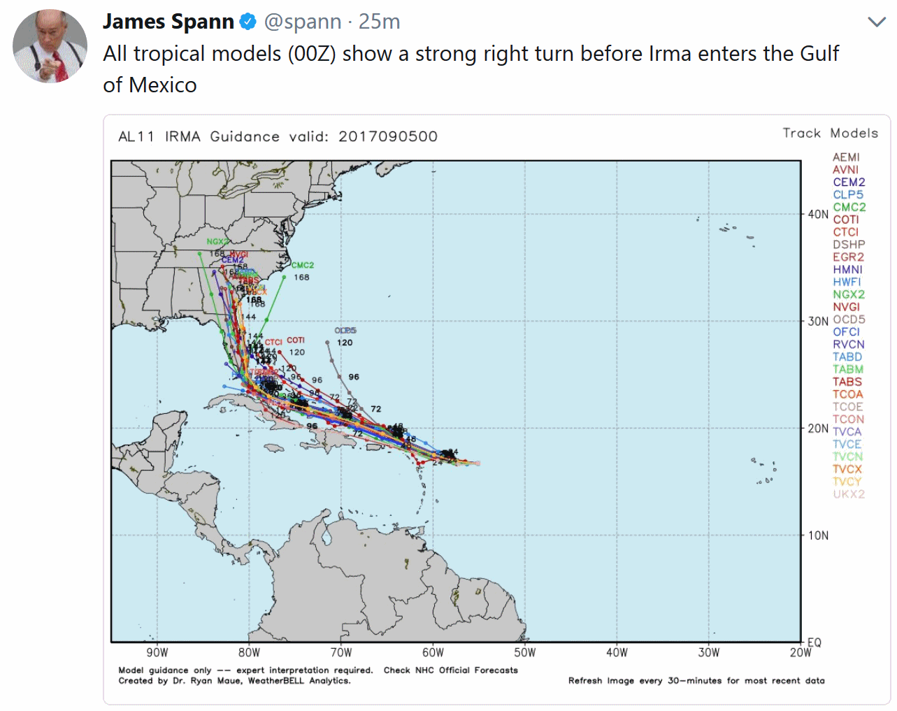
NHC Track. The official track continues to shift south and west with time; a major hurricane predicted off the north shore of Cuba by Saturday afternoon. Along the way the U.S. and British Virgin Islands may see damaging winds and a 4-6 foot storm surge as Irma’s eye tracks just to the north. Puerto Rico may also see significant damage (especially north shore) and power outages. Track: NOAA NHC.
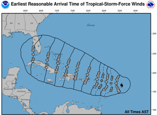
Tropical Storm-Force Winds. The map above is an experimental product from NHC, setting expectations for when sustained winds are predicted to top 39 mph – tropical storm force.

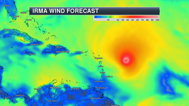
Predicted Wind Field. NOAA’s GFS model shows Irma as a strong Category 3-4 hurricane as is tracks precariously close to the U.S. Virgin Islands, Puerto Rico, the Dominican Republic and Cuba. Animation: Aeris AMP.
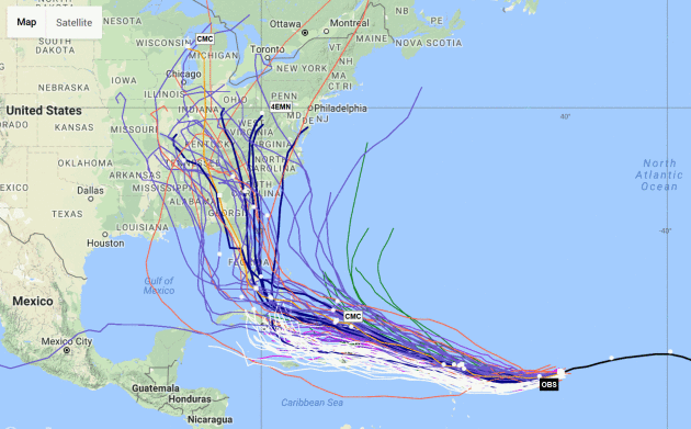
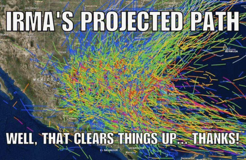
Tropical Cyclone Tracks from Experimental Forecast and Ensemble Models. NOAA ESRL has a page that updates frequently. Welcome to our world – so many models, only one (correct) forecast track.

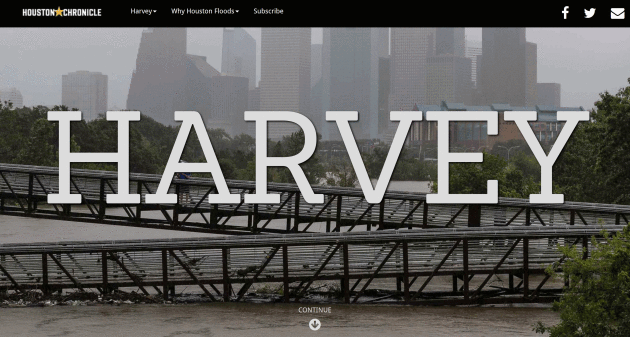
Fifty-One Inches. Terror, Heartbreak and Heroism as Five Houstonians Brave America’s Worst Storm. And here is another reason why we need newspapers to get the real story, the full story – with perspective and context you won’t find anywhere else. Check out this ambitious multimedia story at The Houston Chronicle: “They couldn’t have known that a low pressure system in the Atlantic would, over the next week, grow into the fiercest hurricane to hit Texas in four decades. That it would stall over Houston and dump 51.88 inches of rain at Cedar Bayou in East Harris County, more than any storm in U.S. history…”
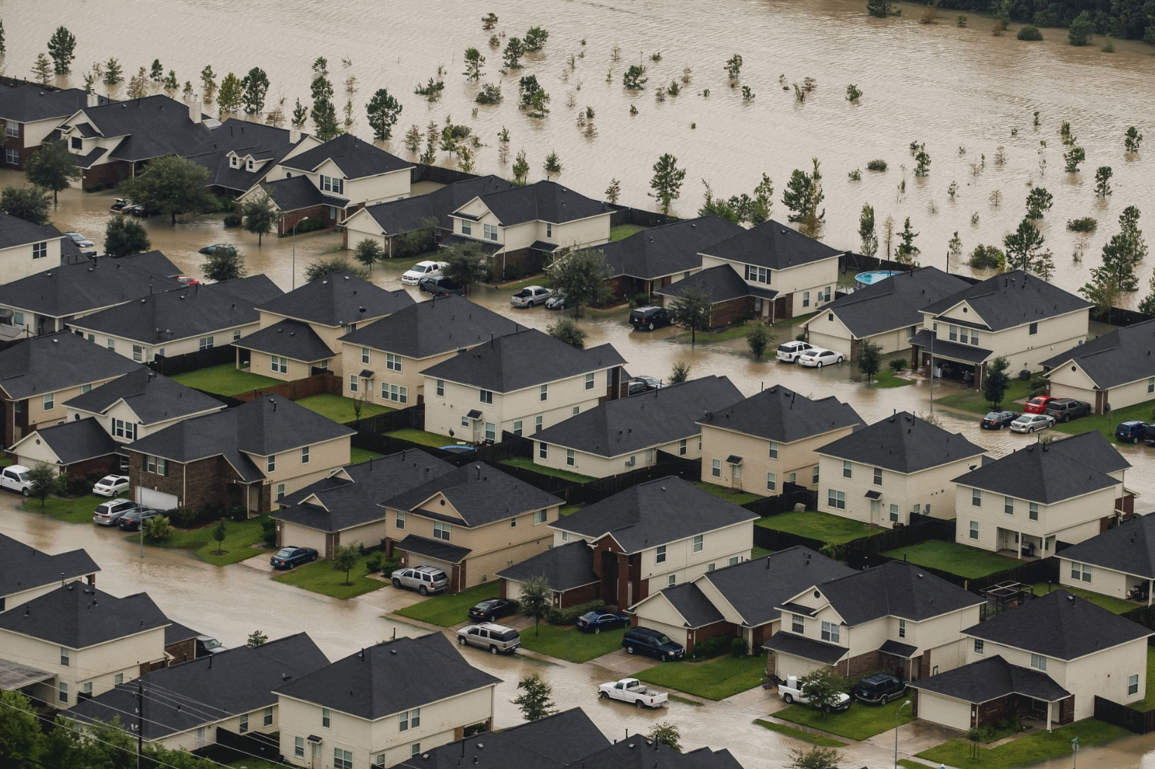
Development and Disasters – A Deadly Combination Well Beyond Houston. Demographic shifts and urbanization near the coast are huge factors – urban sprawl has made the disaster bulls-eye much bigger, and we continue to build in areas that are increasingly vulnerable to rising seas and extreme rains, argues a story at ProPublica: “…Indeed, the economic costs — which will include everything from thousands of ruined and uninsured homes to higher national gasoline prices to lost business activity in the country’s fourth-largest city — will take months to calculate, and years to overcome, said Kevin Simmons, an economist at Austin College focused on storm impacts. “In the Houston metro area alone, there is more than $325 billion in residential value at risk,” Simmons said in an interview. “Most damage to residential property will be flooding and if people don’t have flood insurance they are on their own.” (Most don’t, in part because the floodwaters reached so far beyond established danger zones.) Add in damaged cars, commercial property, lost business and the damage outside of Houston, “The bottom line will likely exceed Katrina,” he said…”
Photo credit: “Residential neighborhoods in Houston, Texas near Interstate 10 sit in floodwater in the wake of Hurricane Harvey.” (Marcus Yam/Los Angeles Times).
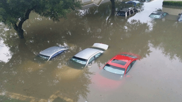
Harvey Wrecks Up to a Million Cars in Driving-Dependent Houston. And be extra-careful if you’re buying a used vehicle in the months ahead, argues a story at WIRED.com: “…And that’s where another specter raises its head: title washing, or taking a damaged vehicle, fixing it up a bit, and fudging the record (either by forgery or taking advantage of legal loopholes by moving states) to hide the fact that it was once the victim of serious problems. A 2014 study by Carfax found there were nearly 800,000 cars on US roads that had been through this sort of fraud; 650,000 of those were flood damaged or salvage vehicles.Because these cars tend to be sold cheap, their sellers are likely to target the many people now in desperate need of a new chariot. “Flooded vehicles will be showing up on the market,” says Fred Britton, owner of Public Auto Auctions in Niederwald, Texas, near Austin...”
Photo credit: Julia Andrews, Houston Chronicle.

14 Famous Business Pivots. Your business model isn’t working out the way you hoped? You can try a new way forward; fail until you succeed. Here’s an excerpt from Forbes: “The most critical decision for an entrepreneur is to know when to stay the course vs. change direction. I’ve spoke at length about how to deal with “The Entrepreneur’s Dilemma.” Today we launched the new version of Docstoc that completes our 6 year evolution from a professional document sharing website to the go-to resource to start and grow small businesses. In part we were inspired by some of the most famous business pivots of some of the most famous brands. Here are fourteen extraordinary examples…”

Here’s When Machines Will Take Your Job, As Predicted by AI Gurus. I don’t worry about immigrants (I’m the son of an immigrant). I worry about really, really smart machines that don’t take vacations and never ask for raises. Here’s an excerpt from Big Think: “…In the next 10 years, we should have AI do better than humans in translating languages (by 2024), writing high-school-level essays (by 2026), writing top 40 songs (by 2028) and driving trucks. And while the consensus may be that driving trucks may come by 2027, it’s easy to predict that this could happen even sooner, with top tech entrepreneurs like Elon Musk constantly pushing the envelope and promising these innovations earlier. A chore that would take less time – folding laundry should be a breeze for AI by 2022. Other tasks might take longer, but still within the foreseeable future...”

Get Ready for Technological Upheaval by Expecting the Unimagined. Following up the story above, here’s a clip from a New York Times article: “…Self-driving vehicles could upend the transportation sector and eliminate a million or more jobs. Algorithms that decode M.R.I.s put a whole medical subfield at risk. And the list of professions and sectors soon to be obsolete grows steadily by the day. New technologies are rattlinng the economy on all fronts. While the predictions are specific and dire, bigger changes are surely coming. Clearly, we need to adjust for the turbulence ahead. But we may be preparing in the wrong way…”
Photo credit: “The best way to prepare for the future may be to prepare for change.” Tim Cook.


You Can’t Kill Bigfoot in Washington and More Odd Animal Laws. Who knew? National Geographic has a story with jaw-dropping details: “…The U.S. laws show all the many ways we relate to animals, as pets, property, food, co-workers, friends, and more, says David Rosengard, the fund’s staff attorney. For instance, in Juneau, Alaska, you can’t take a dog with you into a beauty salon or barbershop; if you’re going hunting in West Virginia, don’t be tempted to take along your ferret for help. Some of these laws are indeed kooky, but others have got horse sense. According to an Ohio law, “no horse owner is allowed to let their stallion mate with a mare anywhere near a public street or alley...”
Photo credit: “Mexican free-tailed bats sail through the night sky in Texas. People in that state can kill the animals if they’re inside the house or on the roof.” Photograph by Joel Sartore, National Geographic Creative.
TODAY: Mostly cloudy, windy & cool. Winds: NW 10-20. High: 64
TUESDAY NIGHT: Clearing and cool. Low: 49
WEDNESDAY: Partly sunny, comfortably cool. Winds: NW 8-13. High: 65
THURSDAY: Sunny and milder. Looking good. Winds: W 7-12. Wake-up: 50. High: 74
FRIDAY: Sunny, still spectacular. Wake-up: 54. High: 77
SATURDAY: Plenty of mild sunshine, no complaints. Winds: SE 10-15. Wake-up: 57. High: 78
SUNDAY: Blue sky holding pattern. Balmy. Wake-up: 61. High: near 80
MONDAY: Another fine September day. Winds: S 7-12. Wake-up: 62. High: 81
Climate Stories…
Four Radical Plans to Save Civilization from Climate Change. I’m still not there yet with geoengineering. Maybe we’ll all have to wrap our heads around stuff that sounds an awful lot like science fiction to avoid worst case scenarios, argues a story at WIRED: “Smug eco-warriors may think they’re curbing global warming with their vegan diets, charged-up Teslas, and rooftop solar panels. But according to Peter Wadhams, head of the Polar Ocean Physics Group at the University of Cambridge, we’re barely staving off disaster. He should know: The pessimistic professor has been studying sea ice for nearly 50 years. “Reducing our emissions is not going to be enough to prevent catastrophic consequences,” he says. In his scorching new book, A Farewell to Ice, he presents a slew of radical—and sometimes theoretical—ways to save civilization…”
Illustration credit: Paul Lacolley.
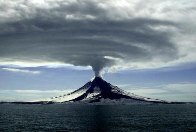
Ancient Global Warming Event Linked to Volcanic CO2. Planetary volcanic eruptions spewing out CO2, methane and other greenhouse gases was responsible for the last (spike) in warming. Now we are the volcano. Here’s an excerpt from New Atlas: “We’re currently breaking climate record after climate record, and it appears that we might be on track to topple a record that’s held strong for about 56 million years. The Palaeocene-Eocene Thermal Maximum (PETM) was the most rapid and extreme example of global warming since the dinosaurs were wiped out, and a new study has found evidence that intense volcanic eruptions were to blame, pumping mind-boggling amounts of carbon into the oceans and atmosphere…”
