Northern Minnesota Snow Friday
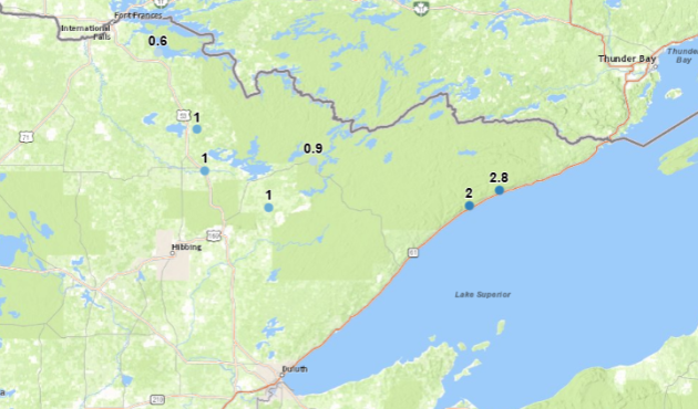
Some mainly light snow fell across northern Minnesota Friday. The highest observed total was 2.8″ in the Grand Marais area, with 2″ in Lutsen. At the Duluth airport, officially 0.2″ of snow fell Friday, bringing the season total so far to 21.3″ (12.5″ above average).
_______________________________________________
Twin Cities Thanksgiving Climatology
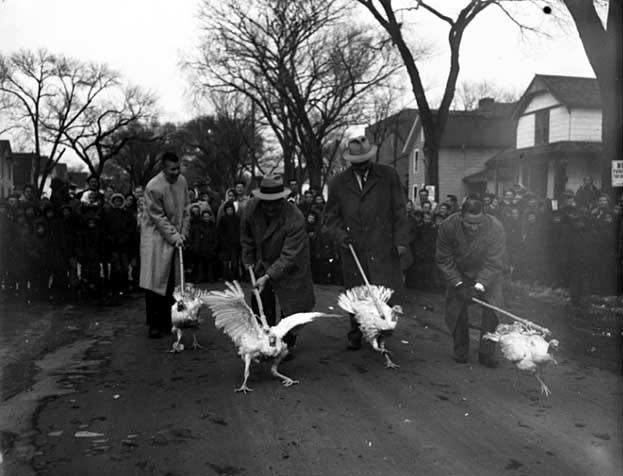
(Image: Turkey Race – 1955. Courtesy: Minnesota Historical Society)
The Minnesota State Climatology Office has put together some Thanksgiving climatology as we approach the holiday on Thursday. The warmest Thanksgiving on record was 62 back in 1914 and 1922, and we have only had a high of 50+ in the Twin Cities on Thanksgiving Day eleven times. Meanwhile, about one in five Thanksgiving have measurable snow that falls during the day, and about one in three have at least an inch of snow on the ground.
_______________________________________________
The Black Art of Weather Forecasting Psychology
By Paul Douglas
Yesterday’s sky was sunnier than predicted, at least over the southern half of Minnesota. Nobody complained much about the busted forecast. You see, when the weather is nicer than predicted most people let it slide. They resist the urge to heckle the meteorologist.
Which brings up a dirty little weather secret: forecasters, as a profession, often err on the side of pessimism or worst-case. It’s human nature; if the weather turns out worse than forecast, especially on a weekend or holiday, the natives get very restless.
On this date in 1981 nearly a foot of snow fell, causing fabric on the Metrodome to rip and collapse. Yes, we could easily be knee-deep in drifts.
Expect more blue sky with less wind today. Monday may bring 50F; the mildest day in sight. A colder front arrives on Tuesday; a light (nuisance) mix of slush possible Wednesday. Thanksgiving day may see highs in the upper 30s, but Black Friday brings mid-40s and a dry sky – before a chance of a little wet snow next Saturday.
On Thanksgiving 1983 we woke up to 10 inches of snow on the ground. Insert gasp here.
_______________________________________________
Extended Twin Cities Forecast
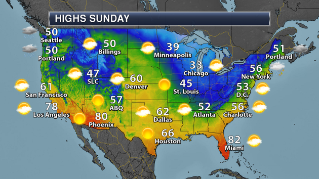
SUNDAY: Partly sunny and cool. High 39. Low 29. Chance of precipitation 10%. Wind SW 7-12 mph.
MONDAY: Intervals of sun, milder breeze. High 50. Low 29. Chance of precipitation 20%. Wind SW 8-13 mph.
TUESDAY: More clouds, colder wind kicks in. High 36. Low 21. Chance of precipitation 10%. Wind NW 10-15 mph.
WEDNESDAY: Light mix, risk of a little slush. High 34. Low 27. Chance of precipitation 50%. Wind S 7-12 mph.
THURSDAY: Serving of blue sky for Thanksgiving. High 35. Low 29. Chance of precipitation 10%. Wind NW 8-13 mph.
FRIDAY: Patchy clouds, but a milder day. High 46. Low 34. Chance of precipitation 20%. Wind S 7-12 mph.
SATURDAY: Colder, wet snow tapers to flurries. High 37. Low 22. Chance of precipitation 60%. Wind NW 15-25 mph.
_______________________________________________
This Day in Weather History
November 19th
1981: Heavy snow with near blizzard conditions is observed over parts of the state. A two day total of 10.4 inches of snow was received at Minneapolis, which caused the inflated fabric of the Metrodome to collapse and rip.
1957: Snowstorm in Southeast Minnesota. A foot is dumped at Winona. Heavy crop losses.
_______________________________________________
Average Temperatures & Precipitation for Minneapolis
November 19th
Average High: 39F (Record: 65F set in 1930)
Average Low: 24F (Record: –5F set in 1932)
Average Precipitation: 0.07″ (Record: 1.00″ set in 1983)
Average Snow: 0.4″ (Record: 6.2″ set in 1981)
________________________________________________
Sunrise/Sunset Times for Minneapolis
November 19th
Sunrise: 7:16 AM
Sunset: 4:40 PM
*Length Of Day: 9 hours, 23 minutes and 49 seconds
*Daylight Lost Since Yesterday: ~2 minute and 11 seconds
*Latest Sunrise At/After 7:30 AM: November 30th (7:30 AM)
*Earliest Sunset: December 5th-13th (4:31 PM)
________________________________________________
Minnesota Weather Outlook

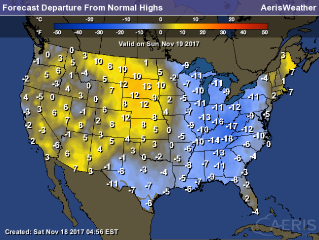
Parts of southwestern Minnesota will be where the warmest weather will be found Sunday as a warm front approaches from the west. Areas like Marshall and Mankato are likely to make it into the 40s for highs during the afternoon. Northern Minnesota will only stay in the 20s for highs. A mix of clouds and sun can be expected across the state.
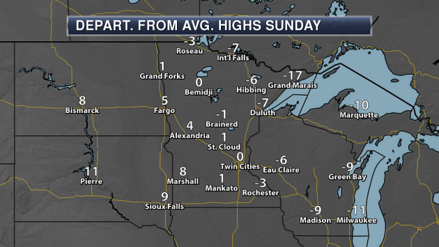
Just like the temperature divide from southwest to northeast Sunday, we’ll see that same divide in the departure from averages. Parts of southwest Minnesota could be up to 10 degrees above average, with northwestern Minnesota mainly between 5-15 degrees below average.
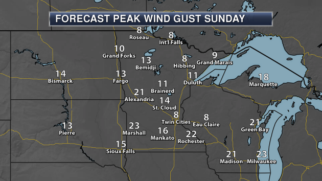
Tired of the blustery weather we’ve had recently? Good news: most of us will get a break in it on Sunday! While winds will still be in the 5-15 mph range across most the state (topping 20 mph potentially across parts of western Minnesota), they certainly won’t be as strong as they have been. Don’t get used to it too long, as it looks like windy weather will return into the beginning and middle of the week.
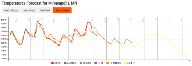
One word can describe the next several days: roller-coaster! After highs in the 30s Sunday, we’ll climb to near 50 Monday with a push of warm air moving into the upper Midwest. A cold front, though, will quickly drop us back into the low 30s Tuesday and Wednesday before another quick warm up commences for Thanksgiving and Black Friday. Cooler weather then can be expected again for your weekend after Thanksgiving shopping adventures – including potentially dropping temperatures throughout the day Saturday.
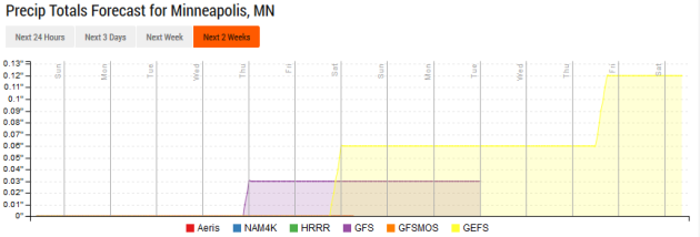
A fairly dry week is ahead. A few of the models hint at light precipitation chances late Wednesday and late Friday, but there is the question of whether there will be enough moisture to work with.
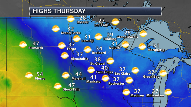
Heading off to grandma’s house for Thanksgiving? Weather looks good across most of the state right now, with dry conditions expected across southern Minnesota and highs in the 30s and 40s. Some light snow will be possible across parts of northern Minnesota (in the International Falls area) as we head toward the evening hours. These areas of the state will see highs in the 20s and low 30s.
________________________________________________
National Forecast
A cold front continues east on Sunday, bringing rain for the Northeast and along the Mid-Atlantic coast. Winds will be blowing from the north and west behind the front, leading to lake effect snow around the Great Lakes. The heaviest lake effect snow will fall across parts of Pennsylvania and New York. A new frontal system will move into the Northwest, bringing rain and higher-elevation snow with windy conditions as well.
As the cold front marches east, cooler than average air will work east as well Sunday. Areas from the Southern Plains to the East Coast and Great Lakes will be 5-20 degrees below average for this time of year. Temperatures over parts of the Northern and Central Plains will be 5-15 degrees above average, with other areas of the west having a mixture of slightly above and below average temperatures.
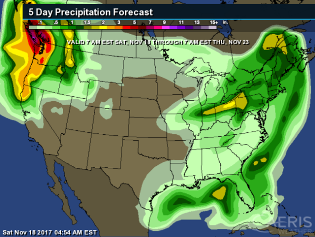
The western U.S. will stay active this week with a couple fronts – one to end the weekend and another one midweek. This could bring several inches of rain to the region through Thanksgiving morning. In the eastern U.S., up to a couple inches of rain will be possible with the frontal system as it continues to move east.
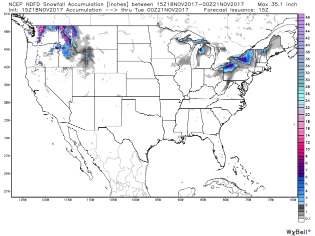
Out west, up to 15″ of snow will be possible for parts of the Cascades through the beginning the week, with up to a foot of snow possible in parts of northern Idaho and western Montana. Periods of lake effect snow will be possible around the Great Lakes, with the greatest amounts expected downwind of Lakes Erie and Ontario Sunday into Monday with up to 8″ possible.
Taking a look toward Thanksgiving holiday travel, on Wednesday rain will be likely across the Northwest with higher elevation snow. Scattered snow showers will be possible around the Great Lakes and into parts of both eastern North Dakota/northwestern Minnesota and New England. A few showers will be possible near the major airport hubs of Washington D.C., New York City and Boston which may cause some travel headaches. Rain will also be possible along the Gulf Coast, especially in parts of Florida, southern Georgia and southern Alabama.
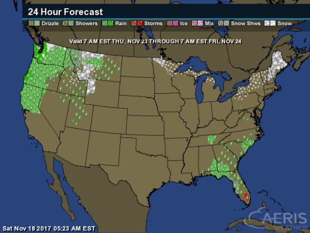
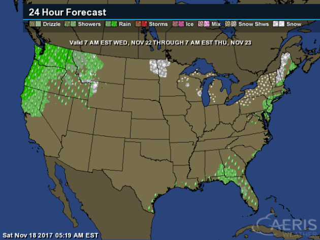
For Thanksgiving Day, rain and snow will continue in the Northwest, causing some travel troubles across the region. Snow will be possible from northern Minnesota to northern Michigan and into northern New England. A few showers will be possible from Florida into the Mid-Atlantic, with a few storms possible over southern Florida.
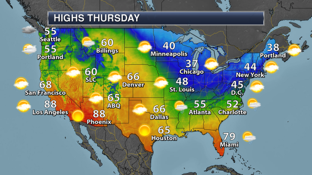
Highs on Thanksgiving will be cool around the Great Lakes in to the Northeast, with highs in the 30s and 40s. Warmer weather can be found in parts of southern California and Arizona, with highs approaching 90 in spots.
________________________________________________
Temperature Preferences
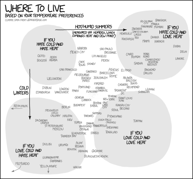
xkcd put together a graphic earlier this week showing where to live based off of temperature preferences, using data from weatherbase.com. Good news here in the Twin Cities – you must love cold and heat to live here. If you love cold… head to McMurdo Station.
More Farmland In The World
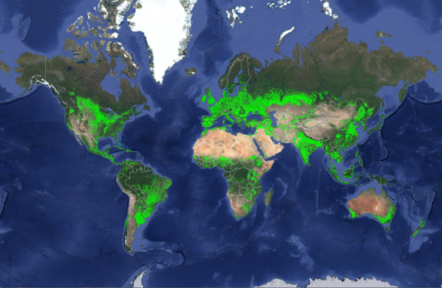
That means there’s more room for crops to grow, right? Total cropland across the world is now estimated at 1.87 billion hectares – however, the United States doesn’t have the most. More from Bloomberg: “There’s more agricultural land in the world than previously thought, and India rather than the U.S. or China is now believed to have the biggest acreage of any country, according to new study aimed at improving food and water security. Global cropland totals 1.87 billion hectares (4.62 billion acres), 15 percent to 20 percent higher than earlier estimates, according to a map released Tuesday by the U.S. Geological Survey. The increase is due to the assessment of areas previously mapped inaccurately, or left unmapped, the USGS said in a statement.” (Image: U.S. Geological Survey)
Less Ice Means A Higher Potential Of Lake Effect Snow
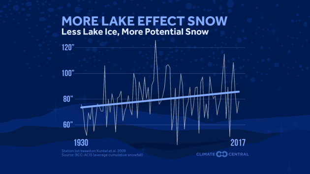
With less ice on the Great Lakes due to climate change, that means the potential is there for more lake effect events. More from wxshift: “Arctic air begins to race across the relatively milder water of the Great Lakes every fall, generating lake effect snow. These snowfalls can be intense, but are often localized. Several inches of snow can fall a few miles away from a place that only gets flurries. As the planet has warmed from the increase in greenhouse gases, so have the lakes, meaning more evaporation into the atmosphere during the winter. Paradoxically, this had led to an increase in lake effect snow, but that trend is not expected to last.” (Image: ClimateCentral)
______________________________________________
Thanks for checking in and have a great Sunday! Don’t forget to follow me on Twitter (@dkayserwx) and like me on Facebook (Meteorologist D.J. Kayser)!
– D.J. Kayser

