
_______________________________________________
Storms Later Today – Feels Like September Thursday
By D.J. Kayser – In For Paul Douglas
Happy August 1st! I’ll give you fair warning right off the top: we are only one month away from the start of meteorological autumn, and a little over a month away from kids all over the state being back in school. Where did the summer go?
We start to see some relief from the summertime heat (at least in the averages) this month. Our average high goes from 83 today in the Twin Cities to 78 by the end of the month. Of course, August still has its fair share of heat and humidity – especially around the State Fair.
If you enjoy the summer temperatures, you better take advantage of today while it lasts. A few storms will be possible later this afternoon, but highs will be in the 80s. Weather later this week will feel more like late September or early October versus early August, with highs not making it out of the 60s Thursday with showers.
So make sure you get out and enjoy the last month of meteorological summer. Our average temperatures are all downhill from here (at least for a few months)!
_______________________________________________
Extended Twin Cities Forecast
TUESDAY: Scattered PM storms. High 85. Low 65. Chance of precipitation 40%. Wind SW 3-8 mph.
WEDNESDAY: Turning cloudy. Showers by the evening. High 80. Low 60. Chance of precipitation 20%. Wind NE 3-8 mph.
THURSDAY: Feels like September. Cool and rainy. High 67. Low 56. Chance of precipitation 70%. Wind E 5-15 mph.
FRIDAY: A few widely scattered PM showers. High 75. Low 59. Chance of precipitation 20%. Wind NW 5-15 mph.
SATURDAY: Mostly sunny. Isolated PM shower. High 76. Low 61. Chance of precipitation 20%. Wind NW 3-8 mph.
SUNDAY: A touch warmer. Pop-up PM shower. High 79. Low 61. Chance of precipitation 20%. Wind W 3-8 mph.
MONDAY: Looks dry and sunny! High 80. Low 63. Chance of precipitation 10%. Wind NW 3-8 mph.
This Day in Weather History
August 1st
1955: A thunderstorm in Becker County dumps a foot of rain at Callaway.
_______________________________________________
Average Temperatures & Precipitation for Minneapolis
August 1st
Average High: 83F (Record: 101F set in 1988)
Average Low: 64F (Record: 49F set in 1962)
Average Precipitation: 0.15″ (Record: 2.03″ set in 1975)
________________________________________________
Sunrise/Sunset Times for Minneapolis
August 1st
Sunrise: 5:58 AM
Sunset: 8:39 PM
*Length Of Day: 14 hours, 40 minutes and 16 seconds
*Daylight Lost Since Yesterday: ~2 minute and 23 seconds
*Next Sunrise At/After 6 PM: August 2nd (6:00 AM)
*Next Sunset At/Before 8:30 PM: August 8th (8:29 PM)
_______________________________________________
Minnesota Weather Outlook
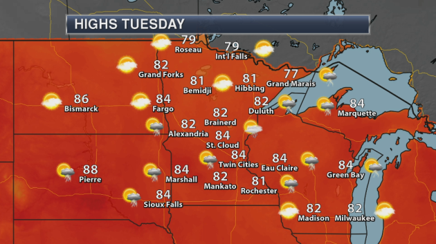
Tuesday will be another nice day temperature-wise across the state, with highs in the upper 70s to mid 80s expected. A few storms will be possible, especially across southern Minnesota and in the Arrowhead, as we head through the afternoon and evening hours.
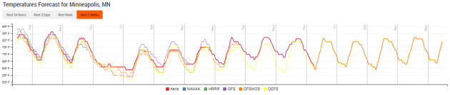
Temperatures will take a dive, however, as we head toward the middle of the week as a storm system passes through the region. Highs will only be in the 60s on Thursday before slowly rebounding into the weekend.
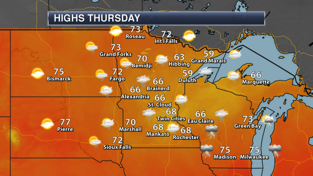
Here’s a closer look at those highs on Thursday across the state. They’ll only be in the 60s with showers across southern Minnesota, meanwhile areas that see a little bit more sun across northern Minnesota will make it into the 70s.
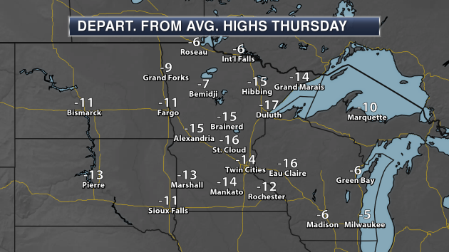
Those highs Thursday across southern Minnesota will be a good 10-20 degrees below average for this time of year as that storm system moves through.
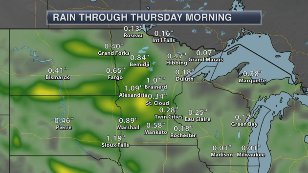
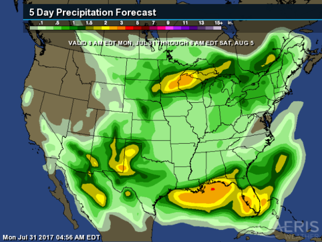
That storm system will also bring rain starting Wednesday Night across the area. While some of this rain is from what is expected Tuesday across the state, the Thursday system will bring heavier rain with it. By the end of the week, parts of central Minnesota could see over 1-2″ of rain.
We’ll watch a few more isolated afternoon rain chances Friday and into the weekend, but those showers and storms are expected to be widespread where not everyone will get rain. Some more rain will then be possible toward the middle of next week.
_______________________________________________
National Weather Outlook
Tuesday’s Forecast
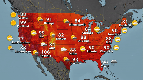
Storms will be possible Tuesday across the central and southwestern United States, as well as in parts of Florida. Highs will make it to around 90 in New York City and flirt with the century mark in Portland, OR.
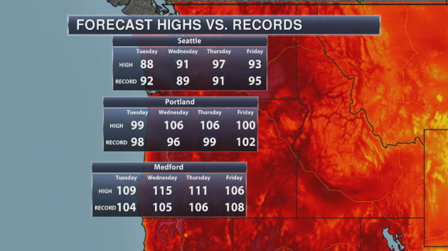
The heat is on to begin the month of August in the Pacific Northwest. By Wednesday, both Medford and Portland could be flirting with all-time record highs.
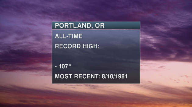
The warmest it has ever been in Portland, OR, was 107°, most recently reached on August 10th, 1981. We are expected to see a high of 106° both Wednesday and Thursday.
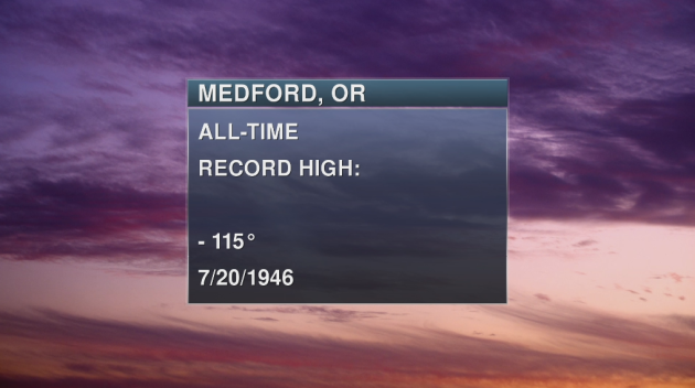
In Medford, OR, the all-time record high is 115° set on July 20, 1946, and there is the potential we could tie that on Wednesday.
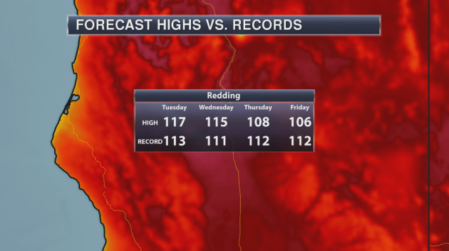
The heat is on in northern California as well. Redding, CA is expected to see a high of 117° Tuesday before cooler weather starts to prevail for the rest of the week.
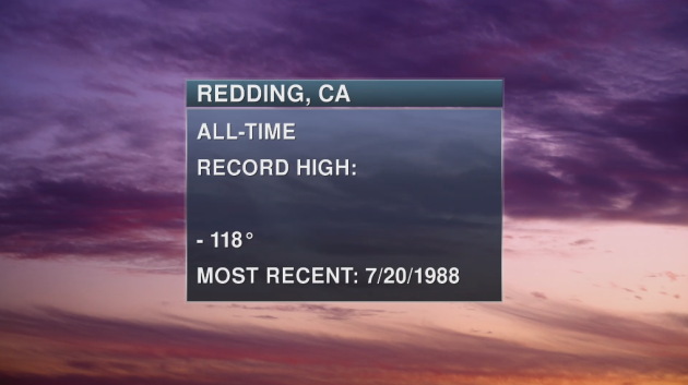
That high tomorrow in Redding could come close to their all-time record high of 118° set most recently in July of 1988.
_______________________________________________
Emily Makes Landfall In Florida
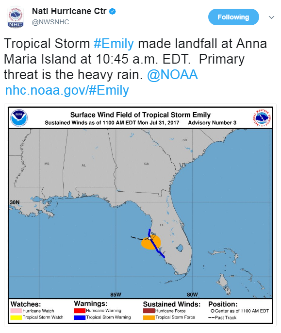
Tropical Storm Emily quickly formed in the eastern Gulf of Mexico early Monday morning, and just as quickly made landfall south of Tampa before 11 AM. The main concern has been heavy rain with this system as it continues to move across the Florida peninsula.
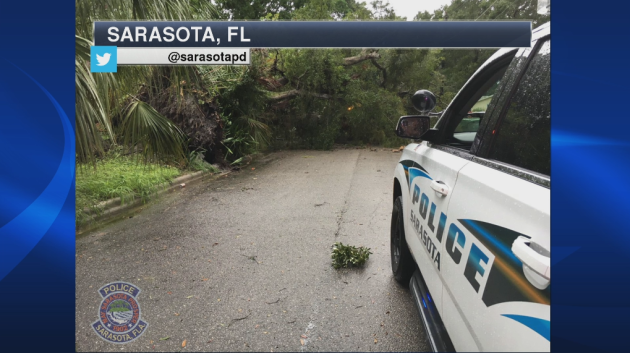
However, this system does have some strong winds gusts with it as well, helping to bring down some trees during the day Monday in the Sarasota area.
Earth Continues To Quickly Warm, According To New Studies
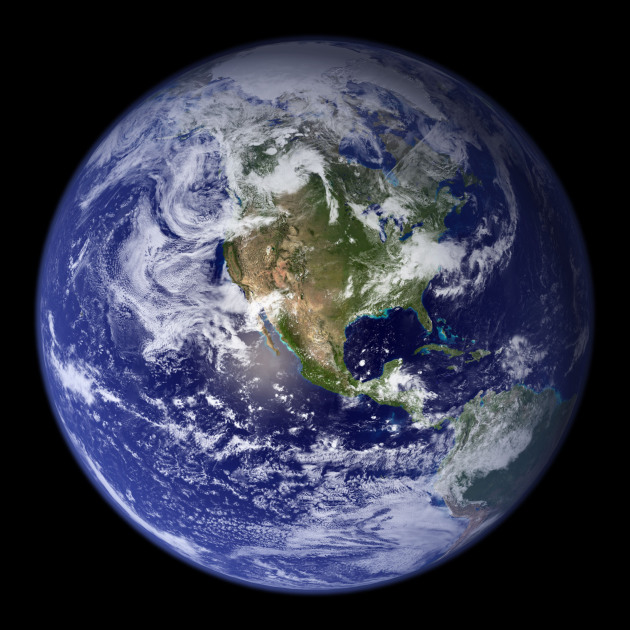
A couple new studies out today show that Earth could warm 2°C by the end of the century, which could have some dire consequences. More from CNN: “By the end of the century, the global temperature is likely to rise more than 2 degrees Celsius, or 3.6 degrees Fahrenheit. This rise in temperature is the ominous conclusion reached by two different studies using entirely different methods published in the journal Nature Climate Change on Monday.”
More Wildfires Out West As The Climate Warms
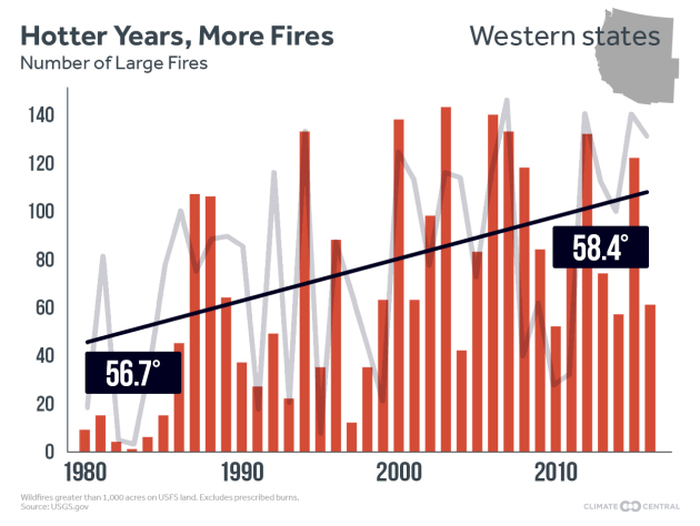
The wildfire season continues across the western U.S., and a comparison from Climate Central shows that hotter years have a correlation with more fires. More from Climate Central: “The West is ablaze as the summer wildfire season has gotten off to an intense start. More than 37,000 fires have burned more than 5.2 million acres nationally since the beginning of the year, with 47 large fires burning across nine states as of Friday.”
Escape To Europa? Not So Fast…
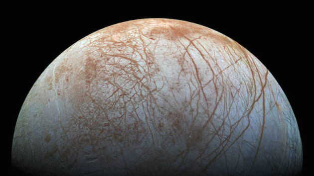
Did you want to make an escape to Europa in the future? Well, even though it is icy, it may still not be habitable. More from Gizmodo: “According to a study published today in Nature Geoscience, researchers used 3D global climate models to simulate how icy worlds around F and G-type stars (like our Sun) might skip a habitable period once they melt. The team found that the simulated worlds required an incredibly high amount of energy to melt the icy surface, and that when the Sun becomes hot enough to do so in a few billion years, they quickly transitioned to a “greenhouse state,” skipping over a habitable phase. The oceans evaporated and left any hope for water-based life out of luck. Since our Sun is a G-type star, this doesn’t bode well for the future of Enceladus and Europa.” (Image: NASA/JPL-Caltech)
Tampa Bay – And The Next Major Hurricane
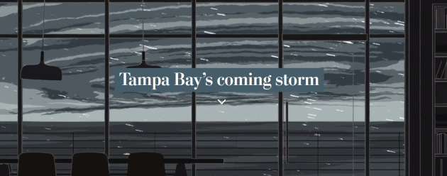
With sea levels on the rise, Tampa Bay is somewhat of a sitting duck right now if a major hurricane struck the area. The damage could even be worse than what was observed during Katrina in New Orleans. More from the Washington Post: “Mark Luther’s dream home has a window that looks out to a world of water. He can slip out the back door and watch dolphins swim by his private dock. Shore birds squawk from nearby nests in giant mangroves. He said it’s hard to imagine ever leaving this slice of paradise on St. Petersburg’s Bayou Grande, even though the water he adores is starting to get a little creepy.”
50/50 Chance Of Rain? Not In Canada

Oh Canada… I actually kind of like this philosophy of having to make a decision one way or another. More from the CBC: “When it comes to forecasting the chance of rain or snow, Environment Canada’s Guide to Public Forecasts is pretty clear: “The use of 50 per cent is not permitted.” Wait. Why not? To understand, it’s a good idea to start at the beginning: What exactly is probability of precipitation or POP? Environment Canada defines it as “the chance that measurable precipitation’ (0.2 mm of rain or 0.2 cm of snow) will fall on any random point of the forecast region during the forecast period.”” (Image: Alistair Steele/CBC)
Iowa And Nebraska Farmers Taking A Hit Due To Dry Conditions
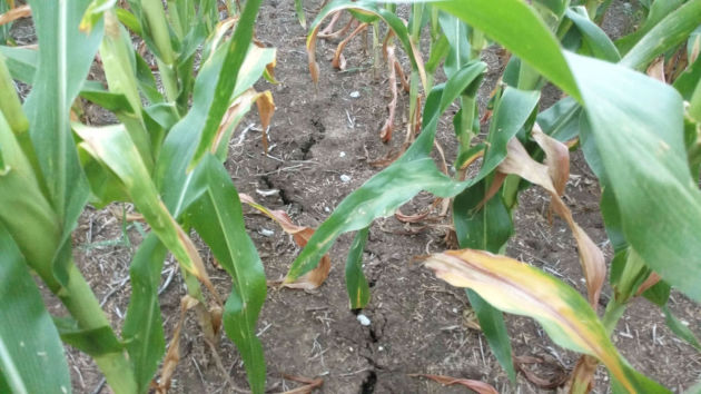
It’s not only the High Plains that are dealing with drought right now. Farmers in Nebraska and Iowa are being hit as well. More from the Omaha World-Herald: “Sioux City-area farmer BJ Hayes is tired of seeing rain in the forecast only to end up with a few tenths of an inch on his corn crop. There are cracks in his soil, and his corn plants are producing smaller ears and ears with fewer kernels. A deepening drought has become a stressful situation for many Nebraska and western Iowa farmers, made worse by the fact that the price for corn — down by about half since it soared in 2012 and 2013 — isn’t budging.” (Image: Despite some rain this week, there are still cracks in the soil on Matt Chambers’ fields in Audubon, Iowa. He’s expecting lower yields this year, and isn’t sure he’ll turn a profit. MATT CHAMBERS)
Rome Is Avoiding Water Rationing In A Drought… At The Moment
Drought isn’t only striking areas in the U.S. – Rome has seen a drought, but they are avoiding water rationing at the moment. More from Reuters: “ROME (Reuters) – Rome water utility ACEA said on Friday the Italian capital had avoided water rationing after regional authorities modified a decree banning withdrawals from a drought-hit lake. The city’s mayor had called on the government to stop water rationing, which ACEA had said would have to be introduced on July 31 if it could not draw on Lake Bracciano, north of Rome. ”
_______________________________________________
Thanks for checking in and have a great Tuesday! Don’t forget to follow me on Twitter (@dkayserwx) and like me on Facebook (Meteorologist D.J. Kayser)!
– D.J. Kayser

