.gif)
Minimal Snow Chances Ahead
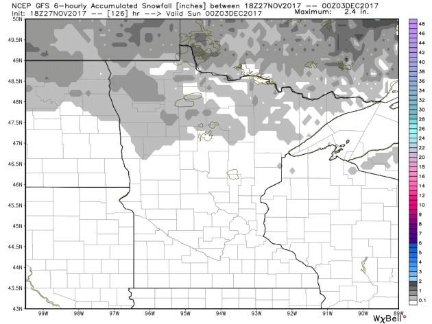
Here’s the snowfall potential through the 2nd day of December, which shows minimal snow chances over the next several days. Snow lovers will have to continue being patient as Old Man Winter takes his sweet time showing up.
Minimal Precipitation Chances Ahead
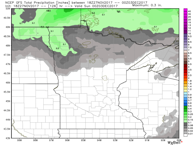
Here’s the precipitation chance through Saturday, which suggests mostly dry conditions continuing across much of the state with the exception of the northern third of the state.
 _________________________________________________________________
 ___________________________________________________________
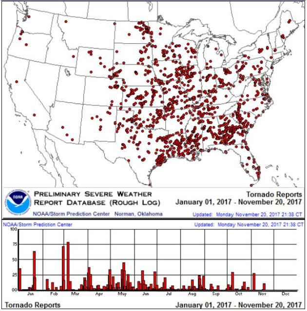
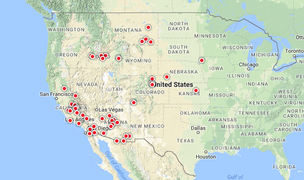
It certainly has been a fairly active first half of 2017 with 1,509 preliminary tornado reports through November 26th. Note that this is the most tornadoes through that date since 2011, when there were 1,880 reports. The map below shows the distribution of the tornadoes so far this year.
PRELIMINARY 2017 Tornado Count
According to NOAA’s SPC, the PRELIMINARY 2017 tornado count is 1,509 (through November 26th). Note that is the most active year for tornadoes since 2011, when there were 1,880 tornadoes. Notice that the only other year with more tornadoes than this year was in 2008, which ended with a whopping 2,140 tornadoes nationwide.
.png)
_____________________________________________________________________
National Weather Hazards Ahead…
1.) Heavy precipitation across portions of the Pacific Northwest, Thu, Nov 30.
2.) Heavy snow across portions of the Pacific Northwest and the Northern Great Basin, Thu, Nov 30.
3.) Heavy precipitation across portions of California, the Central and Northern Great Basin, and the Pacific Northwest, Sat-Sun, Dec 2-Dec 3.
4.) Heavy snow across portions of the Northern Plains, the Northern Rockies, and the Northern Great Basin, Sat, Dec 2.
5.) Heavy snow across portions of the Central Rockies and the Central Great Basin, Sun, Dec 3.
6.) Flooding occurring or imminent across portions of the Pacific Northwest.
7.) Heavy rain across portions of the Southeast, the Lower and Middle Mississippi Valleys, the Ohio Valley, and the Tennessee Valley, Tue-Wed, Dec 5-Dec 6.
8.) Heavy precipitation across portions of the Alaska Panhandle and mainland Alaska, Sun-Mon, Dec 3-Dec 4.
9.) High winds across portions of mainland Alaska and the Aleutians, Thu-Fri, Nov 30-Dec 1.
10.) High significant wave heights for coastal portions of mainland Alaska and the Aleutians, Thu, Nov 30.
11.) Slight risk of much below normal temperatures for portions of the Central and Southern Rockies, the 12.) Central Great Basin, California, the Southern Plains, and the Southwest, Tue-Wed, Dec 5-Dec 6.
13.) Slight risk of much below normal temperatures from the Southern Great Plains to the Southeast and Carolinas, Sat-Mon, Dec 9-Dec 11.
14.) Severe Drought across the Lower Mississippi Valley, the Northern Plains, Hawaii, the Northern Rockies, the Middle Mississippi Valley, the Southern Plains, and the Southwest.
.png)
_____________________________________________________________________
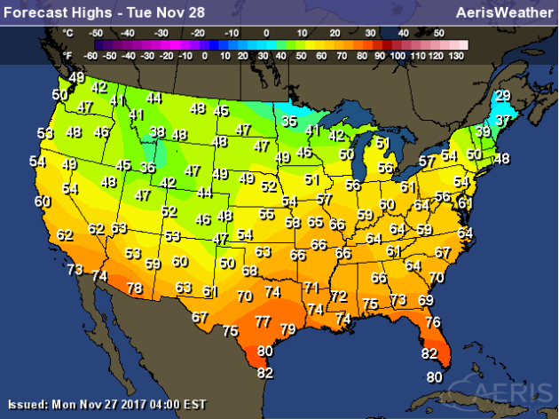
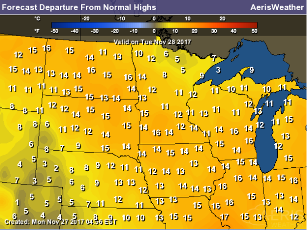
Here’s a look at high temperatures across the nation on Tuesday, which suggests that readings will still be above average for much of the nation. However the only areas that will below average will be the Oklahoma & Texas Panhandle as well as much of Maine.
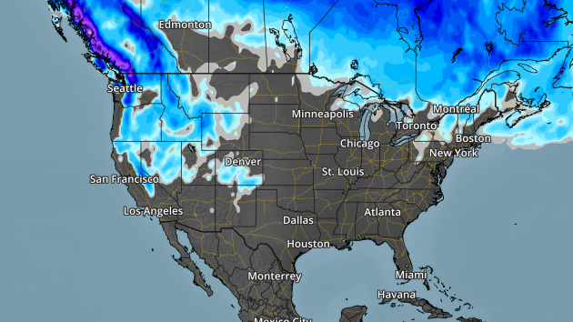
Here’s the weather outlook through Wednesday, which shows a fairly continuous stream of Pacific moisture heading through parts of the Western US. These waves of energy look to dimish some as they head east of the Rockies, but there will still be a little light precipitation across the Southern US midweek.
.gif)
According to NOAA’s WPC, the 5 day precipitation outlook suggests areas of heavier moisture in the Northwestern US with several inches possible in the higher elevations of the Olympics and the Northern Cascades. Some locations in the Northern Rockies could also see some 1″+ liquid tallies through the end of the week. As the storm system move east through the week ahead, there may be some isolated heavier tallies across the Central US and also in the Northeast.
.gif)
By Todd Nelson, filling in for Douglas.HUH? What the heck is “Altweibersommer”? For all you German speakers out there, you may have an idea, but for most of us “Indian Summer” may be a little more recognizable. While the two may not mean exactly the same thing, they are very closely related and refer a warm period of weather from September to mid-November after a hard freeze.
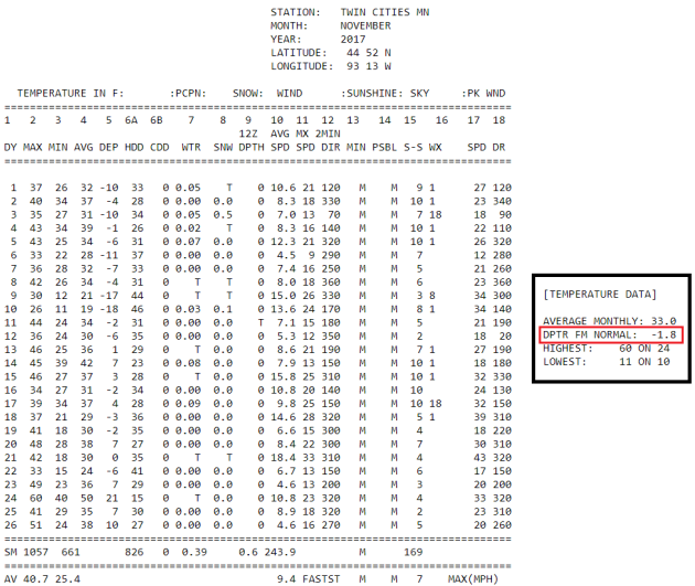
Interestingly, the mercury has hit 60F two times in the last 4 days, which is more like October. It’s also interesting that “Altweibersommer” literally translates to “Old Women Summer”, which seems a little odd. I’m stumped?
I think we’ve tapped the rest of the 60s here in the Twin Cities for a while. Temps will still be running above average, but we’ll cool into more respectable number with readings in the 40s.
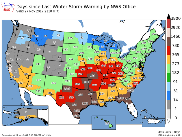
I’m still flabbergasted by the lack of eye-popping storm systems that tend to make wintry weather headlines around parts of the country at this time of the year. Note that it has been 260 days since the Twin Cities NWS has issued a winter storm warning in the county warning area!
________________________________________________________________________
TUESDAY: Sunny. Cooler breeze. Winds: WNW 15-25. High: 48.
WEDNESDAY: Quiet weather continues. Winds: S 5-15. High: 46.
THURSDAY: Light rain/snow mix up north. Winds: WNW 5-15. Wake-up: 31. High: 43.
FRIDAY: Hazy sun. Dry start to December. Winds: SW 5-10. Wake-up: 28. High: 43.
SATURDAY: Remarkably quiet. Winds: SSE 5-15. Wake-up: 28. High: 43.
This Day in Weather History
November 28th
1983: Widespread snowfall occurs across much of central Minnesota with snowfall totals at or above 1 foot in many areas. A record 15 inches fell in Gaylord and 14 inches fell in Farmington.
1960: A major storm produces near hurricane force winds on Lake Superior, with 20 to 40 foot waves on the lake. Erosion and damage occurred on the North Shore.
________________________________________________________
Average High/Low for Minneapolis
November 28th
Average High: 34F (Record: 58F set in 1941)
Average Low: 19F (Record: -21F set in 1887)
Record Rainfall: 1.08″ set in 1987
Record Snowfall: 7.5″ set in 1905
_________________________________________________________
Sunrise/Sunset Times for Minneapolis
November 28th
Sunrise: 7:27am
Sunset: 4:34pm
Hours of Daylight: ~9 hours 6 mins
Daylight LOST since yesterday: ~1 minutes and 42 seconds
Daylight LOST since summer solstice (June 20th): 6 hours & 31 minutes
__________________________________________________________
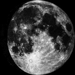
Moon Phase for November 28th at Midnight
2.6 Since First Quarter
_________________________
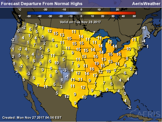
Tuesday will be another mild day across the region with temperatures running nearly 10F to 15F above average. However, it won’t be nearly as warm as it was on Monday as the mercury reached 60F two times in the last 4 days. With that said, temps across the state will warm in the 30s and 40s with an isolated 50F possible across extreme southern MN.
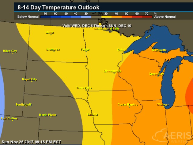
Here’s the temperature outlook through December 12th, which shows very mild temps continuing through the week ahead with readings warming into the 40s to near 50F. The extended forecast suggests temperatures dipping into the 20s and slightly below average as we approach the 2nd weekend of December. Keep in mind that the average high by December 12th is 28F.
.png)
8 to 14 Day Temperature Outlook
Here’s the temperature outlook from into the early part of December, which suggests that temperatures will still be above average for much of the Midwest.
6 to 10 Day Temperature Outlook
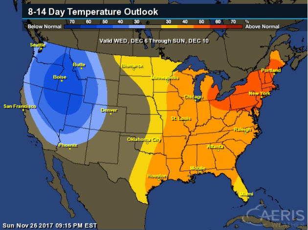
According to NOAA’s CPC – much of the nation will remain above average as we head into the early part of December. The only spot that may see below average temps is in the Western US.
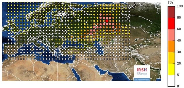
“Here’s What You Need to Know About That Mysterious Radiation Cloud Over Europe”
“After weeks of silence and denials, Russia has confirmed that it too has detected evidence of a mysterious radiation cloud floating above much of Europe, observing a dramatic radiation spike above Russia’s Ural Mountains. The acknowledgement comes after a number of other European nations suggested Russia was the probable origin of the unexplained radiation surge, which was first detected by numerous monitoring stations back in September. Up until this point, Russian authorities had only disclosed they were not aware of any nuclear accidents on their turf, issuing a statement saying “[n]one of the enterprises of the Russian nuclear industry has recorded radiation levels that exceed the norm”. But now Russia’s meteorological service, Roshydromet, has for the first time corroborated findings made by the French Institute for Radiation Protection and Nuclear Safety (IRNS). They acknowledged “extremely high contamination” above the Ural Mountains, detecting levels of the radioactive isotope ruthenium–106 up to almost 1,000 times the normal amount.”
See more from Science Alert HERE:
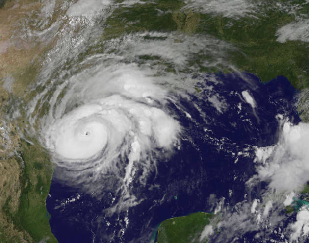
_______________________________________________________________________“Think Hurricane Harvey’s Flooding Was Bad? Just Wait until 2100”
“This season Hurricane Harvey slammed Houston and surrounding southeastern Texas with torrential rains that broke records and created what felt to many like biblical-scale flooding. Harvey was an unusually wet and potent storm by today’s standards—and it may provide a glimpse of North America’s future. A new study predicts the continent will experience more storms that dump similarly huge volumes of rain by the end of the century, thanks to climate change. For the study, published Monday in Nature Climate Change, researchers looked at how global warming will affect storms, called mesoscale convective systems, in North America. These are clusters of smaller storms that grow into one another and eventually act as one. Hurricanes can fall into this category, but the majority of such events in North America are actually giant thunderstorms. They mainly occur east of the Continental Divide, are relatively long-lived and span at least 60 miles (about 100 kilometers)—although they can grow large enough to cover a state as big as Kansas, according to Andreas Prein, the study’s lead author and atmospheric scientist at the National Center for Atmospheric Research.”
See more from Scientific American
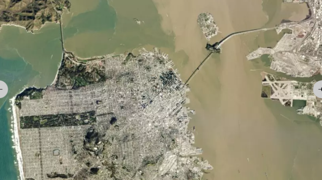
_______________________________________________________________“Every Day, This Satellite Company Takes A Snapshot Of The Entire Planet”
“Planet wants to analyze and index its 1.4 million daily photos to enable researchers to track Earth’s physical changes over time. Six years ago, a group of scientists and engineers, among them three former NASA employees, gathered in a garage in Cupertino, California, with a goal: to found a company whose mission was to capture an image of Earth’s entire landmass every day. To do so, Planet Labs, as they called themselves (they’ve since rebranded to become Planet), had to use satellites small enough and cost-effective enough to launch en masse in a “fleet” that could traverse Earth, snapping images and collecting data. They settled on CubeSat satellites–devices no bigger than a shoebox, and built with consumer smartphone technology for imaging and data collection (the first of this type of CubeSat were built by NASA’s Ames Research Center and inspired by first-generation Google Android phones. The small remote-controlled box, equipped with sensors, floated two miles above the Earth via balloons). As Planet evolved, they began designing and building their own mini satellites, which they call “doves,” and updated their technology simply by switching out the smartphone used for the latest model.”
__________________________________________________________“Mysterious Particles Are Slamming Into Earth—But Why?”
“New observations stir up debate over an abundance of antimatter found in our atmosphere. A cosmic engine is hurling strange particles at Earth—and new observations, published today in the journal Science, are complicating the hunt for the culprit. In 2008, the space-based instrument PAMELA detected an overabundance of particles called positrons in Earth’s atmosphere. These particles are a form of antimatter, a substance that is the opposite of normal matter. When an antimatter positron encounters its opposite particle, the two can annihilate one another and vanish in a tiny puff of energy that often includes gamma-rays, which scientists can detect. (Read about the first antimatter found orbiting Earth.) Figuring out the source of this weird positron excess is exciting, because it helps scientists understand the highest-energy phenomena in the nearby universe, which in turn could help solve some of the big mysteries in physics.”
See more from National Geographic HERE:

__________________________________________________________________“Salting Roads Saves Lives, But Also Takes a Major Environmental Toll”
“This winter, around 17 million tons of rock salt from mines in the U.S. and all over the world will be applied to icy roads across the United States. A growing body of research shows that this salt has become an environmental pollutant, and that we need to start considering alternatives. For most people in states where it snows, seeing rock salt spread on sidewalks and roads is a common sight. But what happens to the salt after the snow melts is less widely understood. Runoff, full of road salt, can flow into nearby streams or ponds and can stay in the environment long after winter is over. Just one teaspoon of salt is enough to permanently pollute five gallons of groundwater used for drinking. Once in the water, salt, or sodium chloride, is difficult to remove. Aquatic life in freshwater ponds, lakes, streams and rivers can also be affected by this runoff, according to Steven Brady, assistant professor in the biology department at Southern Connecticut State University. “It’s salty enough that you can actually taste the salt in these ponds,” Brady told Earther.”

____________________________________________________________________________Thanks for checking in and don’t forget to follow me on Twitter @TNelsonWX

