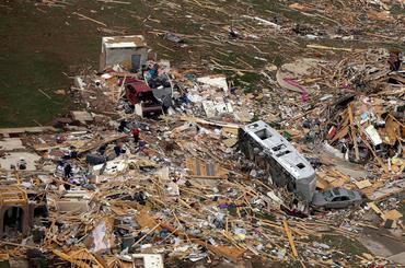
1939: Tornado hits Anoka. 9 were killed and over 200 were injured.
1850: Territorial Governor Ramsey reports that about halfway between Ft. Ripley and Ft. Snelling on the Mississippi a severe hail storm occurred in the evening. One or two hailstones picked up were as large as hens eggs and he thought he saw one about the size of a “musket ball.”

We Surrender
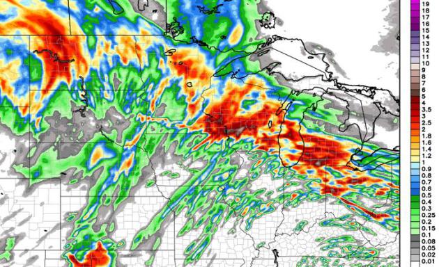
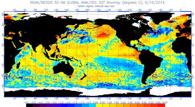
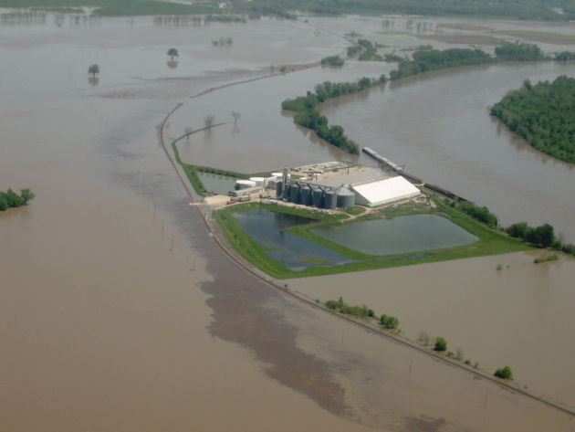
I’ve been standing by the Amish Doppler (window), waving the white flag of surrender, pleading for atmospheric mercy. Please stop the rain! Rivers are out of their banks, there’s standing water in many fields across southern Minnesota and all-time rainfall records are falling.
Pete Boulay at the State Climate Office says it’s the second wettest start to any year since 1871. As of Tuesday MSP was .12 inches from the all-time record in 2001. Dr. Mark Seeley reports “4 of the last 5 Junes (2010, 2011, 2013, and now 2014) have brought historically wet conditions to many parts of southern Minnesota”.
The jet stream appears drunk; winds overhead light and sluggish – meandering unusually far south, prolonging T-storms capable of tropical rains into Thursday. Another inch or two of rain may fall before we dry out Friday and Saturday.
Dew points top 70F the next few days. Men will sweat, women will glow; overflowing lakes more inviting than ever.
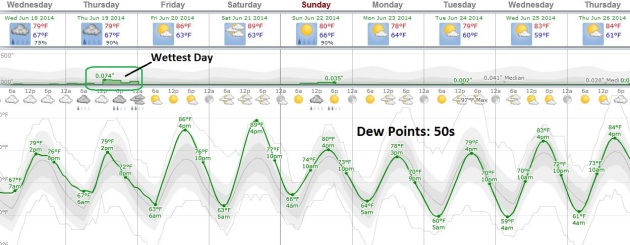
The approach of drier, Canadian air sparks showers Sunday; nearly half as much water floating overhead by Tuesday as dew points drop back into the 50s. A dry, blue sky prevails much of next week with highs near 80F.
Yes, there is a light at the end of this super-saturated, jungle-like tunnel.
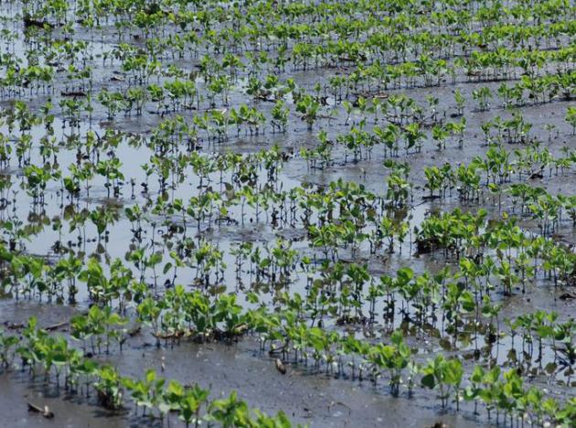

Considerations for Flooded Corn and Soybean. In light of recent flooding and field inundation across much of southern Minnesota here is an excerpt of a very timely story at Crop News, courtesy of the University of Minnesota Extension: “…Young corn can survive flooded condition lasting for about 2 days under warm temperatures (at or above mid-70ºF) to 4 days under cooler temperatures (at or below mid-60ºF). Survivability also is influenced by how much of the plant was submerged and how quickly the water recedes. Corn plants that survived flooded conditions should show new leaf development within 3 to 5 days after water recedes. Flooding and saturated conditions also restrict root development, thereby reducing the crop’s ability to take up water and nutrients and tolerate drought stress later in the season…”
Tornado Forecasting: Scientists Aim To Focus Location, Timeframe. Here’s an excerpt of an interesting article from WTOP.com in Washington D.C.: “Scientists are working to improve tornado forecasting to help save lives and give emergency responders more notice. Researchers at the National Severe Storm Laboratory are working on the Warn-On-Forecast project, which narrows the location a tornado can hit and gives people about 30 minutes notice before it strikes, says NationalGeographic.com writer Brian Clark Howard. The project is slated to be done by 2020. Scientists are combining high-resolution satellite data, forecasts around the country and temperature and moisture levels to better predict a tornado…”
Photo credit above: “Researchers at the National Severe Storm Laboratory are working on project slated to be done 2020 that narrows in on the location a tornado can hit and gives people more notice before it strikes.” (AP)
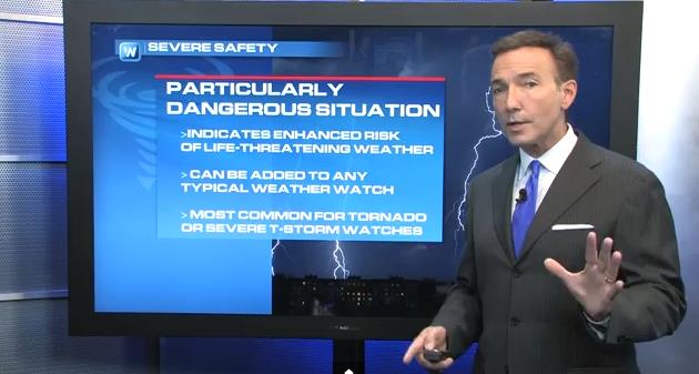
Tornado Terminology. Less than 3% of all watches issued by NOAA SPC are PDS Tornado Watches, but if and when one is issued for your county you’ll want to pay even more attention to unfolding weather conditions. There are, in essence, two grades of tornado watches. The same with tornado warnings. A Tornado Emergency implies a large (confirmed) tornado on the ground, moving into a populated area. That’s the subject of today’s first Climate Matters segment.
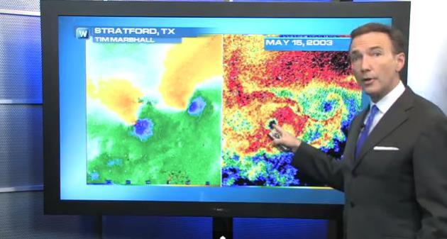
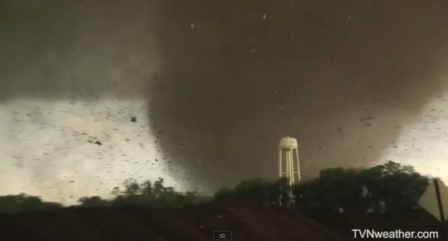
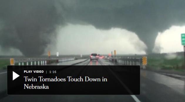
Twin Tornadoes: Rare but Not Unprecedented. There have been several very well documented cases of multiple tornadoes on the ground simultaneously (different that a multi-vortex tornado where smaller funnels are rotating around the same common vortex). What happened in Pilger, Nebraska Monday evening was unusual, but in the second Climate Matters segment we examine previous cases, and end with high-resolution that captured the calm eye() of another 2003 twin tornado – something you don’t see very often.
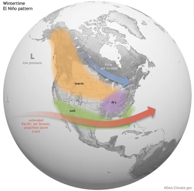
United States El Nino Impacts. Here’s an excerpt of a good summary of previous El Nino events, and the prospect for a moderate El Nino in 2014 to break the drought out west, courtesy of NOAA’s climate.gov: “…In general, El Niño-related temperature and precipitation impacts across the United States occur during the cold half of the year (October through March). The most reliable of these signals (the one that has been observed most frequently) is wetter-than-average conditions along the Gulf Coast from Texas to Florida during this 6-month period. This relationship has occurred during more than 80% of the El Niño events in the past 100 years. Over California and the Southwest, the relationship between El Niño and above-average precipitation is weaker, and it depends significantly on the strength of the El Niño. The stronger the episode (i.e., the larger the sea surface temperature departures across the central equatorial Pacific are), the more reliable the signal in this region has been…”
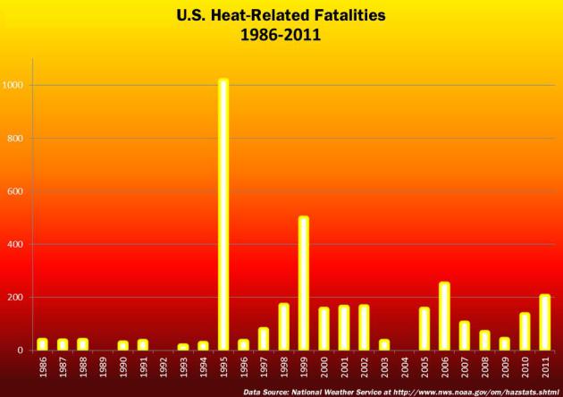
America’s #1 Weather Killer: Heat. Here’s an excerpt from a story at The Midwestern Regional Climate Center: “Heat is the top weather-related killer in the United States. Heat-related fatalities were first officially tallied in 1986, and since then an average of 137 people each year have lost their lives as a result of excessive heat. Heat waves develop over a period of days, and therefore don’t evoke the same sense of urgency as, for example, severe thunderstorms and tornadoes. A heat wave is defined as a period of abnormally and uncomfortably hot and unusually humid weather. Typically a heat wave lasts two or more days. What temperature threshold marks a heat wave varies by geography. For example, a string of four days of 100°F temperatures in Madison, Wisconsin in July would be considered a heat wave because the average maximum temperature in Madison in mid-July is 82°F. Four days of 100°F in Phoenix, Arizona would not be considered a “heat wave”, because the average daily maximum temperature in mid-July in Phoenix is 106°F!”
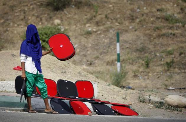
Photo credit above: “An Indian boy, with his face covered to protect himself from the sun, sells sunshades for car windows on a roadside in Jammu, India, Saturday, June 14, 2014. Heat wave conditions prevail in the city with temperature around 41 degrees Celsius (106 degrees Fahrenheit).” (AP Photo/Channi Anand)

Forecast: Overlord. 1994 Local 4 Special Explores Meteorological Planning for D-Day Invasion. Eisenhower’s team of meteorologists accurately predicted a slight break in a major storm over the U.K., a drop in winds and seas that would support an invasion force. Hitler’s meteorologists believed the storm would continue, unabated, with little or no chance the allies would be able to move as massive contingent of troops and supplies into coastal France. Talk about pressure. My friend, meteorologist Paul Gross at WDIV-TV in Detroit, points us to a two-part video series on the meteorological heroes of D-Day: “This week we commemorate the 70th anniversary of World War II’s Operation Overlord, otherwise known as D-Day. The Allied invasion of the Nazi-held French coast at Normandy is widely regarded as one of the most important military operations in history. But the story of how a small band of meteorologists played a decisive role in the invasion’s planning went largely untold for decades…”

“Statistically significant” is one of those phrases scientists would love to have a chance to take back and rename. “Significant” suggests importance; but the test of statistical significance, developed by the British statistician R.A. Fisher, doesn’t measure the importance or size of an effect; only whether we are able to distinguish it, using our keenest statistical tools, from zero. “Statistically noticeable” or “Statistically discernable” would be much better.
Twitter Isn’t As Democratic As You Think. We tend to fixate on celebrity chatter and retweet rumors and opinions – more clutter than substance, according to a story at ThinkProgress; here’s a clip: “…But while social media revolutionizes how the world responds to political and social events, it may be a double-edged sword. Researchers warned that the tendency to fixate on a small number of opinions encourages the proliferation of rumors, misinformation, and political polarization.”
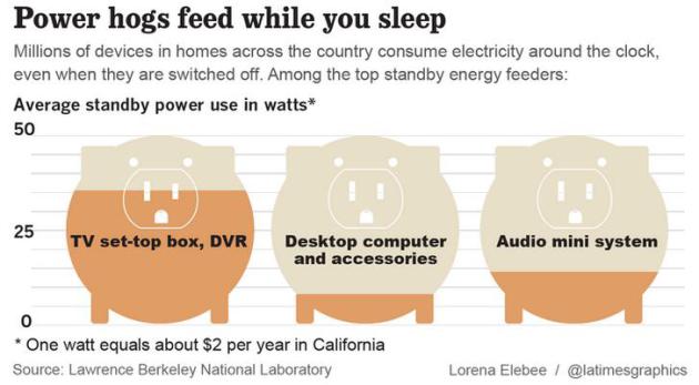
Cable TV Boxes Become Second Biggest Energy Users In Many Homes. This story at The Los Angeles Times made me take a second look at my latest electricity bill; here’s an excerpt: “In the middle of the night, when most Americans are sound asleep, their lights and appliances off, a power hog is wide awake and running at nearly full throttle: the boxes that operate their cable or satellite television service. The seemingly innocuous appliances — all 224 million of them across the nation — together consume as much electricity as produced by four giant nuclear reactors, running around the clock. They have become the biggest single energy user in many homes, apart from air conditioning…”
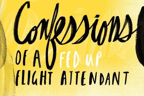
15 Flying Tips That Will Keep You Sane This Summer. A few of these are intuitive, common sense suggestions, but it’s a good recap for those of us about to hit our favorite airports. Oxymoron. Here’s an excerpt from Yahoo Travel: “…Book the first flight of the day. Yes, you have to wake up really early. But the morning flights have a huge advantage because the airplane is already there. You don’t have to worry about delays or weather in some other city where your plane is flying in from…” (Graphic: Ryan McCullah).

TODAY: Some sticky sun, thunder possible by evening. Dew point: 71. Winds: E 10-20+ High: 86
WEDNESDAY NIGHT: Showers and T-storms, locally heavy rain. Low: 70
THURSDAY: More numerous T-storms. More flash flooding? High: near 80
FRIDAY: More sun, warm & dry. Wake-up: 68. High: 86
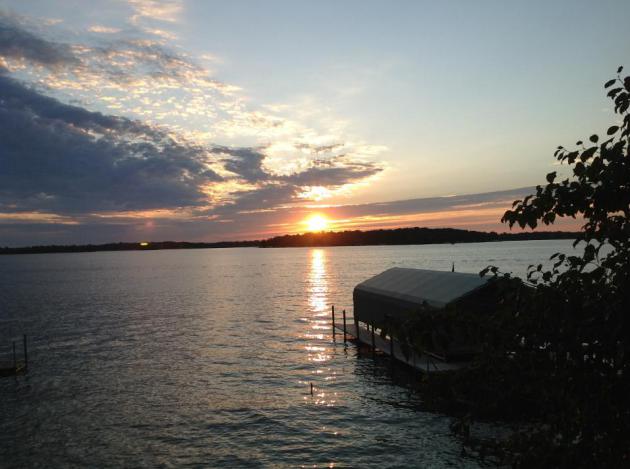
SATURDAY: Nicer day of the weekend? Plenty of sun. Lake-worthy. Wake-up: 62. High: 87
SUNDAY: Unsettled, few showers and T-showers. Wake-up: 65. High: 83
MONDAY: Some sun, less humid. Dew point: 60. Wake-up: 60. High: 78
TUESDAY: More sun. “Pleasant”. Wake-up: 59. High: 80
Climate Stories…
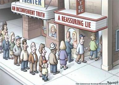
Thanks to cartoonist Clay Bennett, the Christian Science Monitor and Facebook for passing this one along.
Op-Ed. How The Insurance Industry Sees Climate Change. The Los Angeles Times has the editorial; here’s the introduction: “Twenty years ago, I interviewed Frank Nutter, then and now president of the Reinsurance Assn. of America, on the threat climate change posed to the $2-trillion-plus global property and casualty insurance industry. “It is clear,” he said back then, “that global warming could bankrupt the industry.” But in the two decades since, the industry mostly limited itself to talk, sponsoring innumerable reports on the threat. Now a major insurance company has moved to protect itself, and it may be the most important milestone yet in the struggle to contend with global warming…”


Saving The World Should Be Based On Promise, Not Fear. Here’s an excerpt of a unique perspective on dealing with environmental risk from George Monbiot at The Guardian: “… I don’t know anyone who became an environmentalist because she or he was worried about ecological impacts on their bank balance. Almost everyone I know in this field is motivated by something completely different: the love and wonder and enchantment nature inspires. Yet, perhaps because we fear we will not be taken seriously, we scarcely mention them. We hide our passions behind columns of figures. Sure, we need the numbers and the rigour and the science, but we should stop pretending these came first…”
