
___________________________________________________
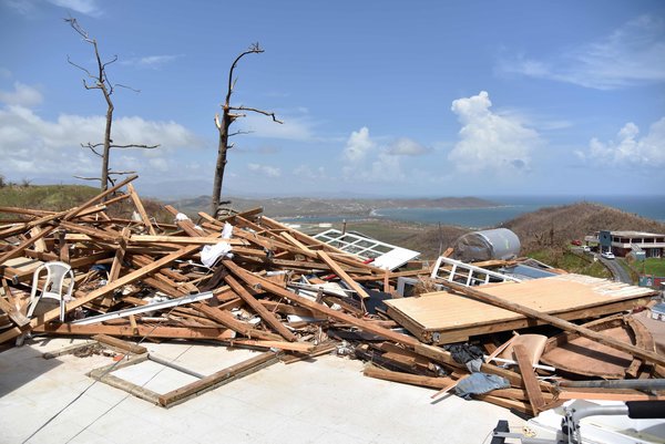
“Almost nothing on the planet, short of nuclear weaponry, destroys economic value as rapidly as a mega-hurricane. In Puerto Rico, decades of economic progress were undone in 12 hours by Hurricane Maria. With millions lacking electricity or potable water, avoiding a humanitarian disaster should be President Trump’s top priority. But these immediate needs are just the beginning of Puerto Rico’s long road to recovery. As Congress considers an aid package in the days and weeks ahead, it’s important to grasp the truly extraordinary scale of the storm’s economic devastation. Hurricane Maria was an absolute monster. By our calculation, the average exposure in Puerto Rico was winds of 123 miles per hour. Normally, only small areas get slammed, and indeed some locations suffered through Category 5 winds of 158 m.p.h. But what stands out about Maria is that if you were anywhere in Puerto Rico on Sept. 20, you would have been experiencing something that felt like passing through a strong Category 3 hurricane. There was nowhere to hide.”
(A house in ruins in Puerto Rico. HECTOR RETAMAL / AGENCE FRANCE-PRESSE — GETTY IMAGES via NYTimes)
_______________________________________________________________
Eagle Mountain
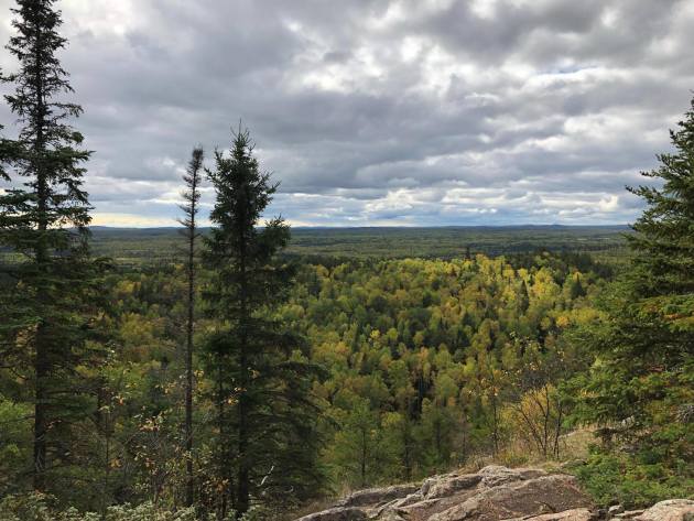
Minnesota Fall Color Update
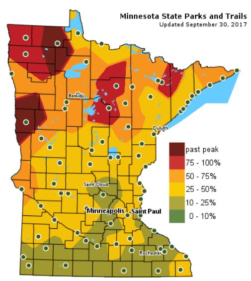
According the MN DNR, much of the state is starting to see hints of fall color, however, there are pockets of peak color across northern Minnesota! Interestingly, some in northwestern Minnesota are already passed peak.
Follow along as the fall colors change with the MN DNR map HERE:
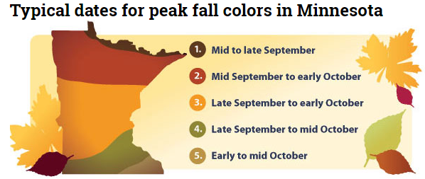
Typical Fall Color Peak in Minnesota
Here are the typical fall color peak times across the state of Minnesota and note that areas along the northern tier of the state usually see their peak toward the 2nd half of September. However, peak color usually doesn’t arrive in central Minnesota until October, but we’re getting close.
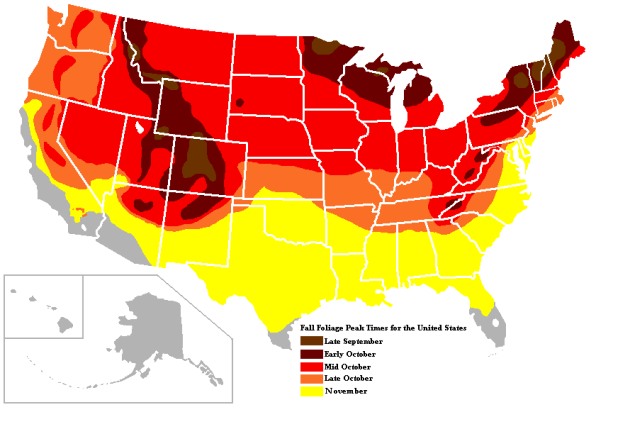
Typical Fall Color Times Across the Country
Here are the typical fall color peak times across the country, which suggests that much of the peak across the northern half of the nation usually wraps up through the month of October.
__________________________________________________________
_____________________________________________________________________
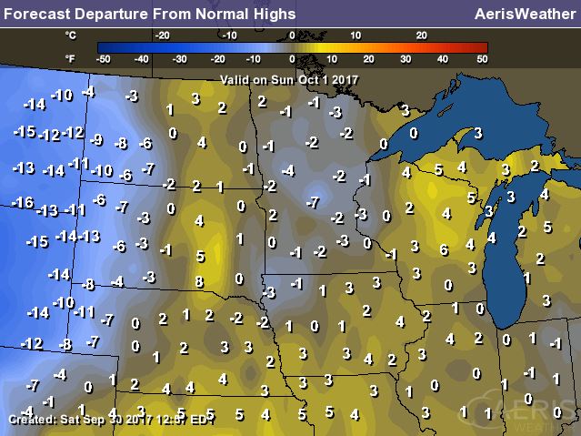
More on the Record-Breaking Warmth From September 22nd-24th
“As the 2017 fall began, summer staged an impressive comeback in Minnesota. On Friday September 22nd, Minnesota found itself stuck between a strong and persistent high pressure area over the eastern United States, and a nearly stationary low pressure system and cold front to the west. In between, unseasonably warm and moist air flowed up into the state from the south and southwest, pushing temperatures into the 80s up to the Canadian border, with 90s common across the southern half of Minnesota. Dew point temperatures well into the 60s and 70s streamed into the state as well, resulting in heat index values exceeding 100 degrees in some places.”
(Image Credit: MN DNR)

_____________________________________________________________________
Record Setting Accumulated Cyclone Energy
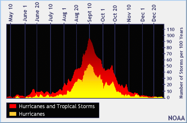
The month of September spawned several very strong hurricanes in the Atlantic basin. In fact, these storms were so strong that the amount energy that was accumulated by these storms was record setting! It narrowly beat the previous record, which was set in 2004.


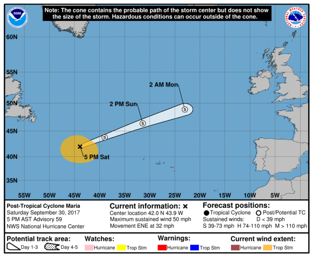
Tracking MARIA
Here’s a visible satellite image of MARIA, which as of Saturday evening was downgraded to a post-tropical cyclone with sustained winds of 50mph. MARIA has had a pretty long life in the Atlantic. The National Hurricane Center starting monitoring this wave on September 13th, which became a tropical storm on the 16th and by the 18th became a category 5 hurricane with sustained winds of 160mph. The good news is that MARIA is weakening fast as is quickly lifts into the North Atlantic.
.gif)
Tracking MARIA
Here’s the official track from NOAA’s NHC, which shows the storm quickly moving into the North Atlantic through the rest of the weekend and into early next week. The strong upper level winds are playing a big role in MARIA’s quickened pace and interestingly, some of the remnants of this storm could end of getting close to Europe by midweek.
_______________________________________________________________
Atlantic Outlook Next 5 Days
.png)
.gif)
.png)
___________________________________________________________
It certainly has been a fairly active first half of 2017 with 1377 preliminary tornado reports through September 22nd. Note that this is the most tornadoes through September 29th since 2011, when there were 1,796 reports. The map below shows the distribution of the tornadoes so far this year.
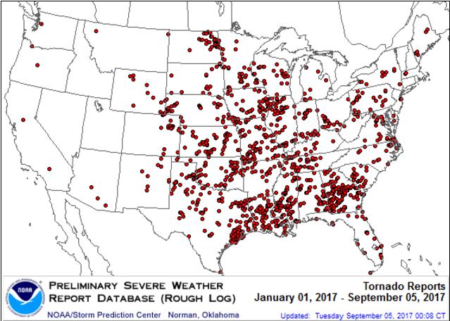
PRELIMINARY 2017 Tornado Count
According to NOAA’s SPC, the PRELIMINARY 2017 tornado count is 1377 (through September 29th). Note that is the most active year for tornadoes since 2011, when there were 1,796 tornadoes. Keep in mind there was a major tornado outbreak in the Gulf Coast region from April 25-28, 2011 that spawned nearly 500 tornadoes, some of which were deadly. That outbreak is known as the Super Outbreak of 2011 and has gone down in history as one of the biggest, costliest and one of the deadliest tornado outbreaks in history.
.png)
_____________________________________________________________________
National Weather Hazards Ahead…
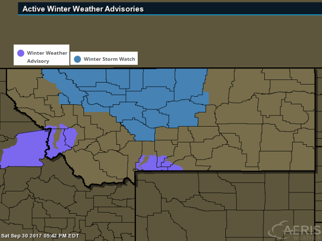
1.) Heavy snow for parts of Montana, Mon-Tue, Oct 2-3.
2.) Much below-normal temperatures for parts of the western U.S., Mon-Wed, Oct 2-4.
3.) Periods of heavy rain for the upper Mississippi Valley, Great Lakes, and parts of the northern and central Great Plains, Mon-Thu, Oct 2-5.
4.) Heavy rain for parts of the lower Mississippi Valley, Mon, Oct 2.
5.) Heavy rain for parts of the southern Florida peninsula and Florida Keys, Mon-Wed, Oct 2-4.
6.) Flooding occurring or imminent along the St. Johns and Withlacoochee Rivers across the Florida peninsula.
7.) Severe drought across parts of the northern Rockies, northern and central Great Plains, Midwest, and Hawaii
.png)
_________________________________________________________
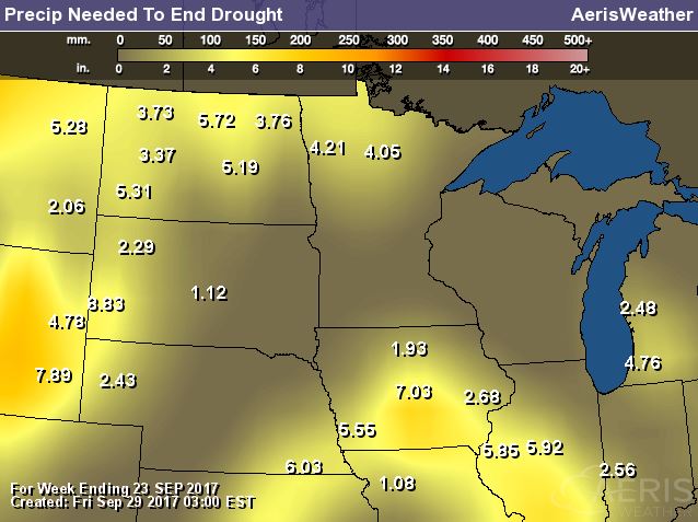
“The Great Wheat Drought That Spooked Traders Seems Overblown”
“When drought spread across the Northern Plains this summer, traders feared the worst for the U.S. spring-wheat crop. Those concerns now seem overblown. The U.S. Department of Agriculture on Friday said growers harvested 416.2 million bushels of the grain this year, topping a previous outlook and the average estimate by analysts surveyed by Bloomberg. At the peak of the drought, some experts were dreading a crop as small as 300 million bushels. The agency’s report sent spring-wheat futures tumbling as much as 3.8 percent on Friday. The price is down almost 19 percent this quarter, the biggest loss in three years. Early in the summer, drought spread across much of North Dakota and Montana, the two biggest growers of the variety of grain used to make bread, bagels and pasta. Luckily for bakers, rains came later and brought some relief. At the same time, yields in Minnesota rose to the highest ever, allowing the state to become the second-largest U.S. grower, trailing North Dakota.”

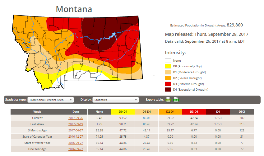
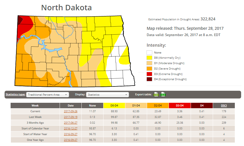
Here’s the latest drought update from the US Drought Monitor, which shows EXCEPTIONAL drought conditions continuing across parts of Montana. Note that nearly 94% of the state is considered to be abnormally dry, but the EXCEPTIONAL drought covers nearly 18% of the state, which is the same as last week. In North Dakota, less than 1% is in an EXCEPTIONAL drought, but nearly 3% of the state is still in an EXTREME drought, which is also the same as last week.
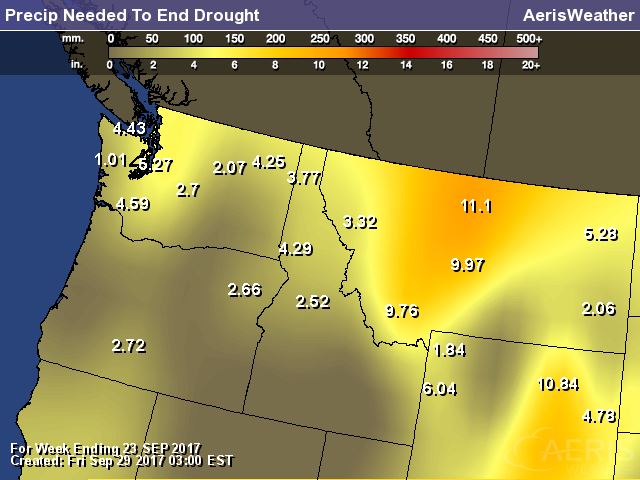
Rain Needed to End Drought
Chetco Bar Fire – 5 Miles Northeast of Brookings, OR
The Chetco Bar Fire near Brookings, Oregon is a very large wildfire in the Western US that started on Wednesday, July 12th by lightning and has grown to more than 191,000 acres! There are nearly 465 people working on this fire, which is 97% contained. The estimated containment date is set for Sunday, October 15th.
“Incident Summary: Firefighters continue to complete equipment recovery and fire suppression repair work on the Chetco Bar Fire. Over 160 miles of hose has been retrieved from the fire perimeter. Crews continue to work with chippers to dispose of brush that was cut when fire lines were constructed and to bring soil, duff and vegetation back over constructed hand lines. Excavators are working to repair dozer lines by spreading soil, duff, tree limbs and logs across the constructed lines to naturalize the area and are creating waterbars as needed to prevent soil erosion. With the return to warmer weather over the next few days, smoke may appear from very interior areas of the Chetco Bar Fire where fire could be smoldering in stump holes or large logs. Firefighters will continue to monitor and patrol the fire perimeter and respond as needed to these areas.”
(Credit: Inciweb)
 Rice Ridge Fire – 1.4 Miles NE of Seeley Lake, MT
The Rice Ridge Fire near Sleeley Lake, MT is another very large wildfire that started on Monday, July 24th due to lightning. The fire has grown to more than 160,000 acres and is 87% contained. There are 193 people working on the fire and they hope to have it fully contained by Sunday, October 15th.
“The Rice Ridge Fire was detected on July 24, 2017. It grew to the current size of over 160,000 acres. With a change of the weather and the onset of fall, fire activity has significantly slowed although firefighters and engines continue to patrol and cool hot spots that are near the fire’s edge. The perimeter in the Scapegoat and Bob Marshall Wildernesses are continually monitored for heat and fire activity.
Fire suppression repair is in full swing, with a large variety of heavy equipment and a couple hand crews working to restore road surfaces, diminish roadside slash, install erosion barriers and similar work to repair resources that were affected by fire operations. Hauling back pumps and other equipment no longer needed, removing fire protective wrap from bridges and other structures, and opening trail access is also high priority work. The Northern Rockies Wildland Fire Management Team is managing the fire, under command of Diane Hutton (IC) and Joe Sampson (IC Trainee). Refer to the daily update under the News Tab for details.”
(Image Credit: Inciweb – taken on 9/14/2017)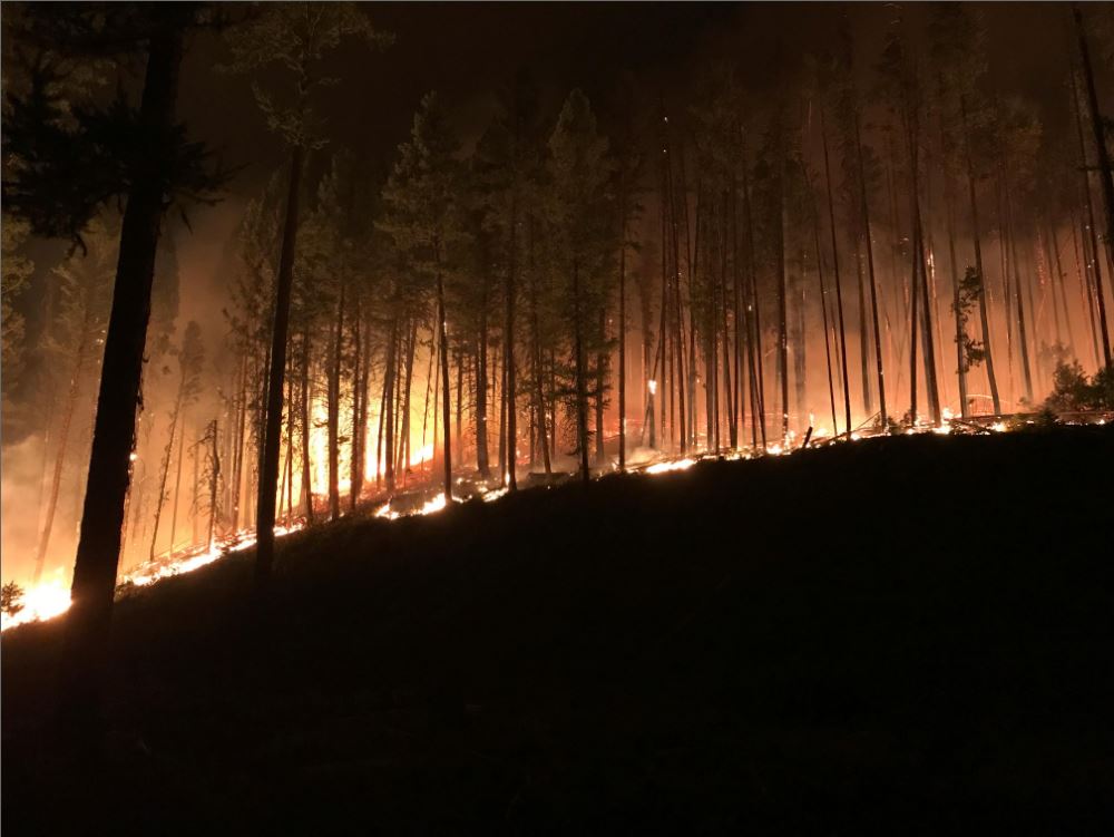
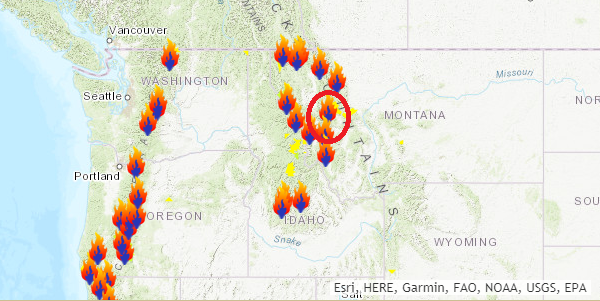
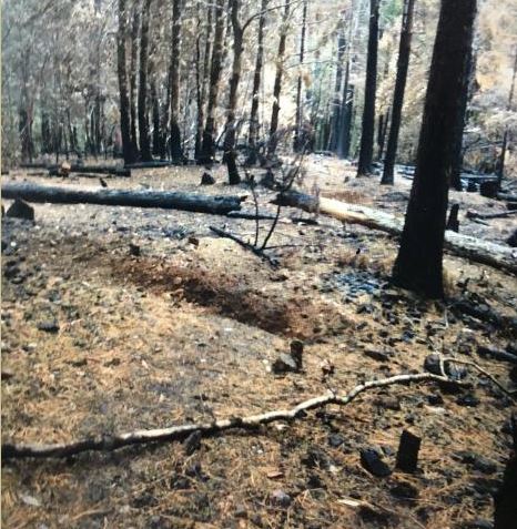
Diamond Creek Fire – Mazama, Washington
The Diamond Creek Fire near Mazama, Washington is a very large wildfire in the Western US that started on Sunday, July 23rd and has grown to more than 128,000 acres! There are nearly 202 people working on this fire, which is 80% contained. The estimated containment date is set for Sunday, October 15th.
“Incident Summary: The Diamond Creek Fire was reported on July 23, 2017 at approximately 9:45 a.m. The fire is burning in the Pasayten Wilderness and Eightmile drainage about 11 miles north of Mazama, Washington. Smokejumpers responded to the fire within two hours of it being reported. However, due to extreme terrain, heavy dead and down timber, and critical fire weather conditions, the fire was unable to be contained during initial response. The fire crossed into Canada on August 29. Fire managers recognized that the Diamond Creek Fire would likely be a long term event. Monitor, confine and point protection strategies are being used inside the Pasayten Wilderness. Outside the wilderness, the fire is being managed under a suppression strategy using a mixture of direct, indirect and point protection tactics when and where there is a high probability of success. Fire personnel will engage the fire at the appropriate time and location, while keeping public and firefighter safety as the top priority. Fire personnel are currently focused on identifying and implementing suppression repair work on the primary and contingency control lines. The suppression repair will not compromise the intended purpose of the control lines should they be needed at a later date.”
(Night time picture of a glowing yurt Credit: Brent Tannehill) 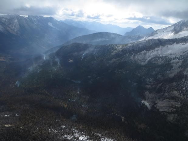
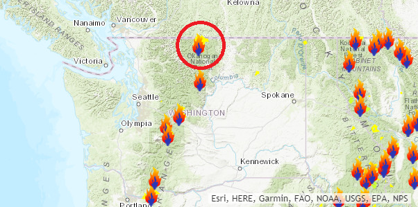
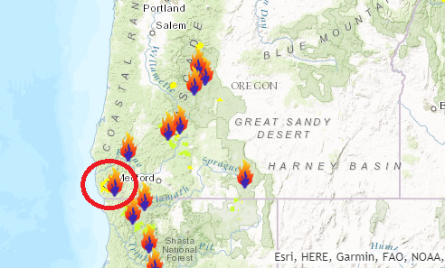
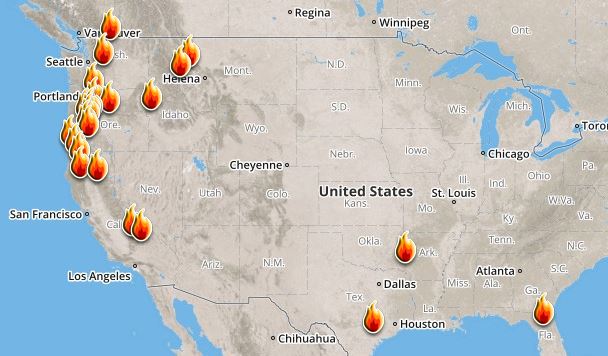
Ongoing Large Wildfires
Here’s a look at the current wildfire map across the country. While several fires are still ongoing, recent cool and somewhat wet weather has been helping curb the wildfire threat.
Here’s a list of all the current large wildfires from Inciweb:
National Weather Outlook
Here’s the weather outlook through early next week, which shows a stalled front across Florida and the Gulf Coast, which will help to bring widespread T-storms to the region, some of which could produce heavy rainfall. There will also be some unsettled weather across the western half of the country, which will bring widely scattered showers and storms across the Plains, while heavy snow will fall again in the mountains.
.gif)
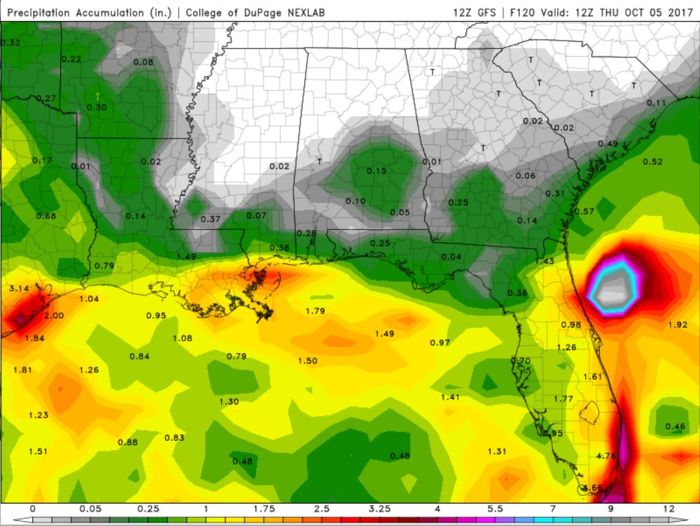
According to NOAA’s WPC, the next several days could produce very heavy rainfall across the Florida and the Gulf Coast with some 1″ to 3″+ tallies possible. There will also be prolonged areas of rain across the Midwest and the Plains. Some areas there could see 2″ to 4″+ through midweek and possibly even more through the end of the week.
.gif)
.png)
By Todd Nelson, filling in for DouglasWANTED – A bottle of Saturday’s weather to open on a rainy day. Anyone? I wish it was that easy.
Our bright fall sunshine from yesterday has been replaced by weather fit for a duck today. Those running in the Twin Cities Marathon will likely have to battle soggy shoes and socks, but it could be worse. True runners are hardy folk and will battle most elements to grind out a few miles. Good luck and have a great race!
A stalled frontal boundary will be responsible for scattered showers and storms through much of the first full week of October. Widespread 1 to 3 inch rainfall tallies maybe possible by Friday. By then, we’ll all be ready to ditch the umbrellas.
By the way, The average high in the Twin Cities on the first day of October is 65 degrees and by the end of the month it is 51 degrees. We also average 0.6 inches of snow! In fact, on this date back in 1999, one of the earliest significant snowfalls of the season hit southern Minnesota. 4 inches fell in Montgomery; 2.8 inches fell in Mankato. I’ll take a Rain check please!
________________________________________________________________________
_______________________________________________________
This Day in Weather History
October 1st
1999: One of the earliest significant snowfalls in Minnesota history falls in a narrow track across southern Minnesota. Reported snowfall totals include 4.0 inches in Montgomery (Le Sueur County) and Northfield (Rice County), 3.8 inches in Springfield (Brown County), 3.0 inches in Vesta (Redwood county), and 2.8 inches in Mankato (Blue Earth County).
1989: High temperatures across central and southern Minnesota reach the 80’s. Later in the day, a cold front would come through and drop the mercury to the 40’s.
________________________________________________________
Average High/Low for Minneapolis
October 1st
Average High: 65F (Record: 87F set in 1897)
Average Low: 45F (Record: 24F set in 1974)
Record Rainfall: 1.29″ set in 2009
_________________________________________________________
Sunrise/Sunset Times for Minneapolis
October 1st
Sunrise: 7:11am
Sunset: 6:53pm
Hours of Daylight: ~11 hours 41 mins
Daylight LOST since yesterday: ~3 minutes and 6 seconds
Daylight LOST since summer solstice (June 20th): 3 hours & 56 minutes
__________________________________________________________
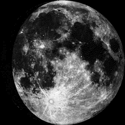
Moon Phase for October 1st at Midnight
3.5 Days Until Full “Harvest” Moon
“Oct. 5, 2:40 p.m. EDT– Full Harvest Moon. Traditionally, this designation goes to the September full moon that occurs closest to the autumnal (fall) equinox. This year’s Harvest Moon comes unusually late. At the peak of the harvest, farmers can work into the night by the light of this moon. Usually, the moon rises an average of 50 minutes later each night, but for the few nights around the Harvest Moon, the moon seems to rise at nearly the same time each night: just 25 to 30 minutes later across the U.S., and only 10 to 20 minutes later for much of Canada and Europe. Corn, pumpkins, squash, beans and wild rice — the chief staples of Native Americans — are now ready for gathering.”
_________________________
Sunday will be a pretty typical early October day with temps in the 60s across much of the state except across northern MN where readings will be in the 50s. Dewpoints will also be on the increase as scattered rain showers start moving in.
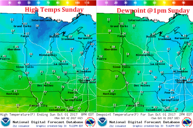
Weather Outlook For Sunday
Sunday could be fairly wet as scattered showers and a few thunderstorms push through. The best chance of rain looks to be across the northern half of the state.