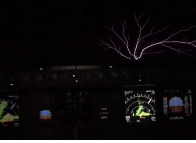
“When you’re hurtling through a thunderstorm at thirty-seven thousand feet, a lot of wacky stuff can happen. Of all the crazy things to see though, one of them is rarer and more spectacular than just about everything else: the incredibly-elusive St. Elmo’s Fire. The phenomenon, a fork-shaped discharge of atmospheric electricity that’s not lightning but has that look, was caught on camera earlier this week on a flight from Rome to Barcelona. As the plane flew over the French island of Corsica, it encountered a strong thunderstorm. The plane entered a region of an exceptionally high electric field, which touched off the amazing spectacle. Maria Ines Rubio was the lead flight attendant on this supercharged flight. She’s worked in the industry for over a decade, and was “hoping to someday see this.” “I was in the cockpit, bringing dinner to the pilots,” she said. “It lasted about three minutes. I wasn’t nervous, because it a rather normal occurrence when you get into a strong enough storm.” The video she shot shows dozens of flashes dancing across the plane’s windshield, arcing like small lightning bolts along the skin of the aircraft.”
See more from WashingtonPost HERE:
(Image Credit: @Ines_Rubio Via WashingtonPost)
_______________________________________________________________“The data that prove bad weather alters your mood”

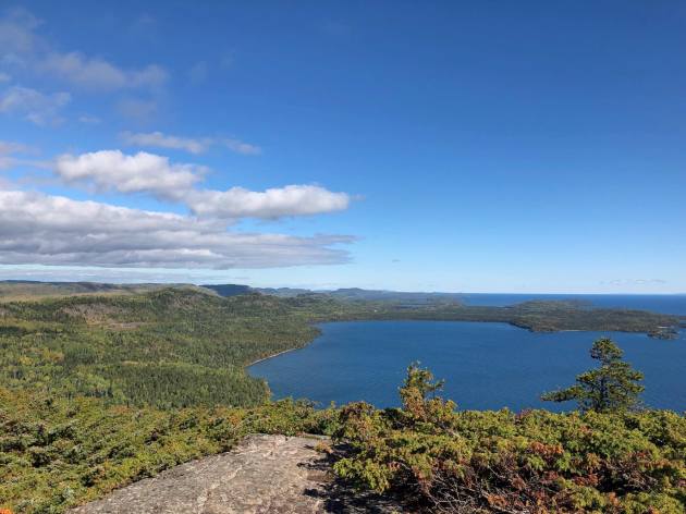
Mount Josephine
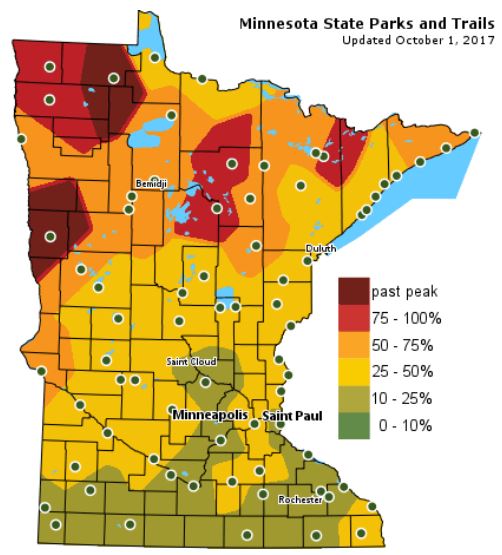
According the MN DNR, much of the state is starting to see hints of fall color, however, there are pockets of peak color across northern Minnesota! Interestingly, some in northwestern Minnesota are already passed peak.
Follow along as the fall colors change with the MN DNR map HERE:
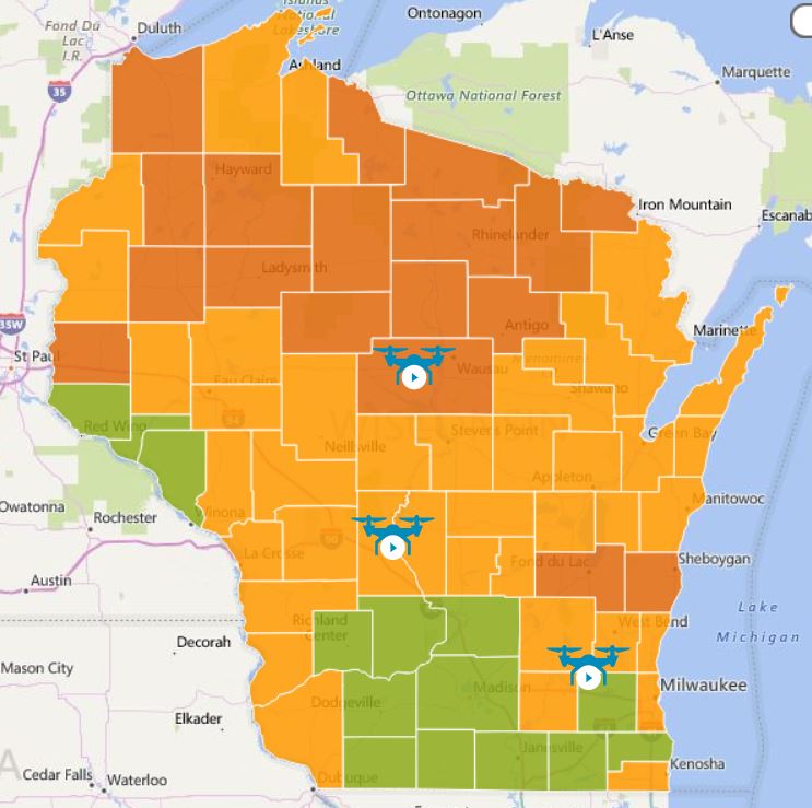
Wisconsin Fall Color Update
We’re also seeing quite a bit of color show up across the northern half of Wisconsin with many locations now nearing 50%-75% color!
See more from Travel Wisconsin HERE:

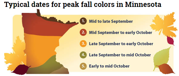
Typical Fall Color Peak in Minnesota
Here are the typical fall color peak times across the state of Minnesota and note that areas along the northern tier of the state usually see their peak toward the 2nd half of September. However, peak color usually doesn’t arrive in central Minnesota until October, but we’re getting close.
__________________________________________________________________
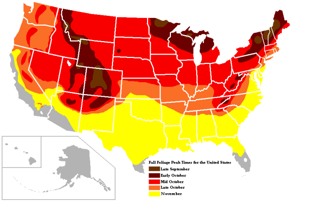
Typical Fall Color Times Across the Country
Here are the typical fall color peak times across the country, which suggests that much of the peak across the northern half of the nation usually wraps up through the month of October.
_____________________________________________________________________
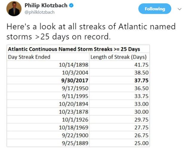
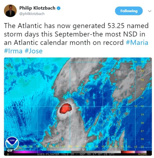
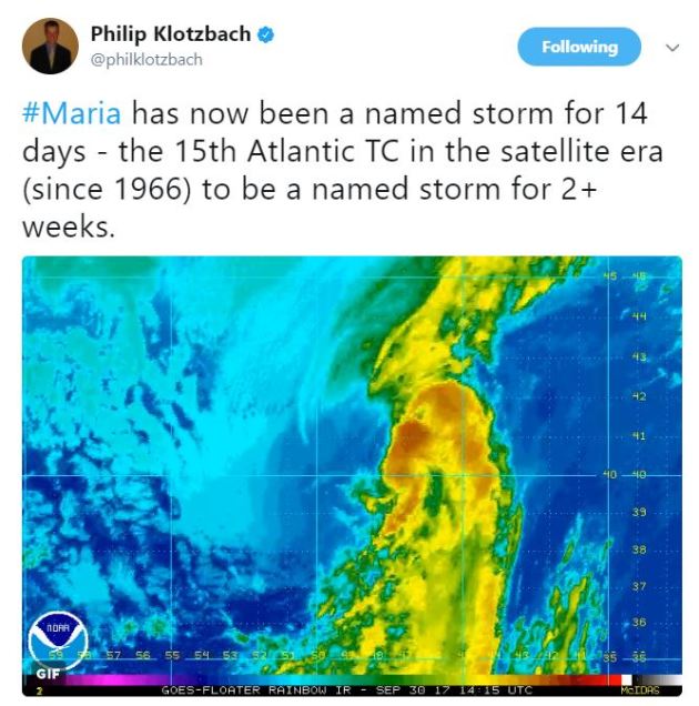
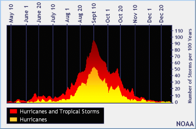
Record Number of Named Storm Days in September
_______________________________________________________________
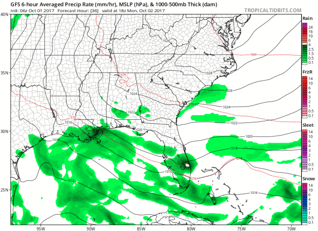
Atlantic Outlook Next 5 Days
.png)
.png)
___________________________________________________________
It certainly has been a fairly active first half of 2017 with 1378 preliminary tornado reports through September 30th. Note that this is the most tornadoes through September 30th since 2011, when there were 1,796 reports. The map below shows the distribution of the tornadoes so far this year.
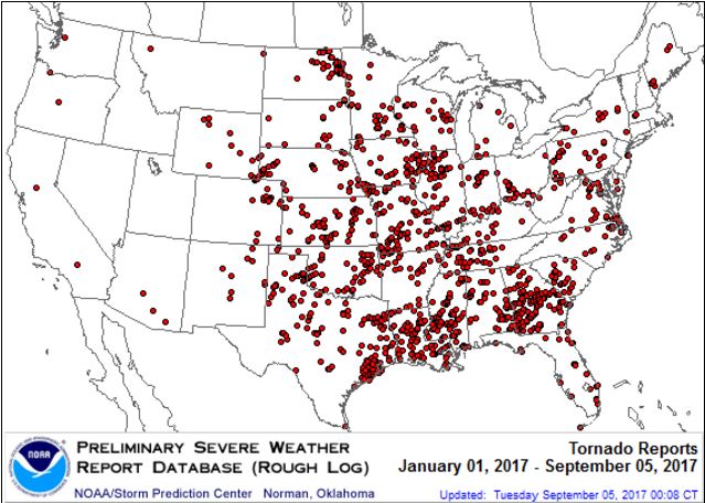
PRELIMINARY 2017 Tornado Count
According to NOAA’s SPC, the PRELIMINARY 2017 tornado count is 1378 (through September 30th). Note that is the most active year for tornadoes since 2011, when there were 1,796 tornadoes. Keep in mind there was a major tornado outbreak in the Gulf Coast region from April 25-28, 2011 that spawned nearly 500 tornadoes, some of which were deadly. That outbreak is known as the Super Outbreak of 2011 and has gone down in history as one of the biggest, costliest and one of the deadliest tornado outbreaks in history.
.png)
_____________________________________________________________________
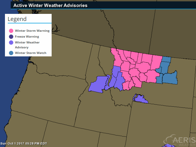
National Weather Hazards Ahead…
1.) Heavy snow for parts of Montana, Mon-Tue, Oct 2-3.
2.) Much below-normal temperatures for parts of the western U.S., Mon-Wed, Oct 2-4.
3.) Periods of heavy rain for the upper Mississippi Valley, Great Lakes, and parts of the northern and central Great Plains, Mon-Thu, Oct 2-5.
4.) Heavy rain for parts of the lower Mississippi Valley, Mon, Oct 2.
5.) Heavy rain for parts of the southern Florida peninsula and Florida Keys, Mon-Wed, Oct 2-4.
6.) Flooding occurring or imminent along the St. Johns and Withlacoochee Rivers across the Florida peninsula.
7.) Severe drought across parts of the northern Rockies, northern and central Great Plains, Midwest, and Hawaii
.png)
_________________________________________________________
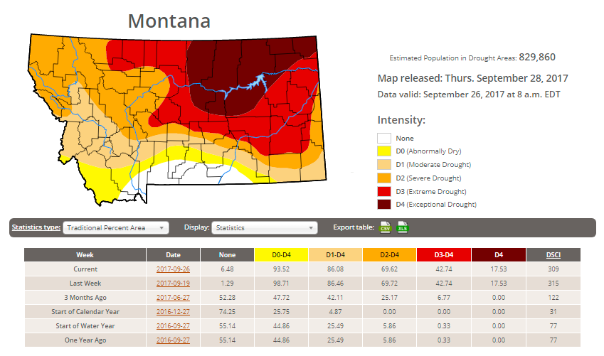
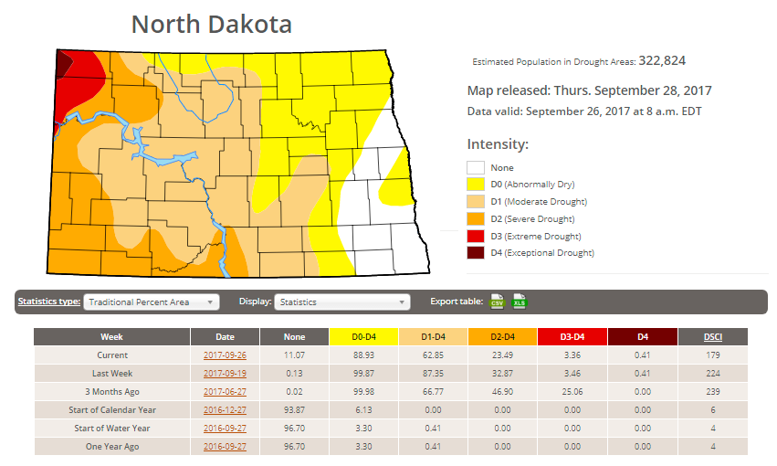
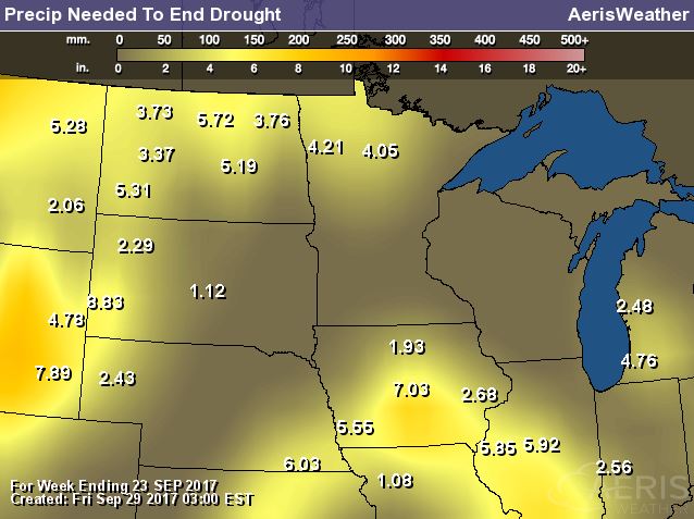
Latest Drought Monitor
Here’s the latest drought update from the US Drought Monitor, which shows EXCEPTIONAL drought conditions continuing across parts of Montana. Note that nearly 94% of the state is considered to be abnormally dry, but the EXCEPTIONAL drought covers nearly 18% of the state, which is the same as last week. In North Dakota, less than 1% is in an EXCEPTIONAL drought, but nearly 3% of the state is still in an EXTREME drought, which is also the same as last week.
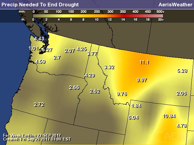
Rain Needed to End Drought
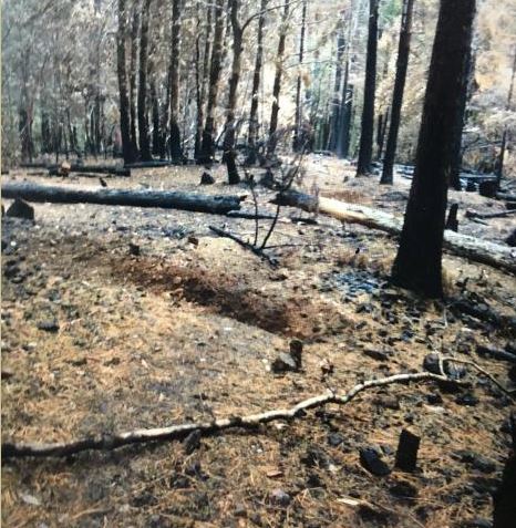
Chetco Bar Fire – 5 Miles Northeast of Brookings, OR
The Chetco Bar Fire near Brookings, Oregon is a very large wildfire in the Western US that started on Wednesday, July 12th by lightning and has grown to more than 191,000 acres! There are nearly 359 people working on this fire, which is 97% contained. The estimated containment date is set for Sunday, October 15th.
“Incident Summary: Firefighters continue to complete equipment recovery and fire suppression repair work on the Chetco Bar Fire. Over 160 miles of hose has been retrieved from the fire perimeter. Crews continue to work with chippers to dispose of brush that was cut when fire lines were constructed and to bring soil, duff and vegetation back over constructed hand lines. Excavators are working to repair dozer lines by spreading soil, duff, tree limbs and logs across the constructed lines to naturalize the area and are creating waterbars as needed to prevent soil erosion. With the return to warmer weather over the next few days, smoke may appear from very interior areas of the Chetco Bar Fire where fire could be smoldering in stump holes or large logs. Firefighters will continue to monitor and patrol the fire perimeter and respond as needed to these areas.”
(Credit: Inciweb)
 Rice Ridge Fire – 1.4 Miles NE of Seeley Lake, MT
The Rice Ridge Fire near Sleeley Lake, MT is another very large wildfire that started on Monday, July 24th due to lightning. The fire has grown to more than 160,000 acres and is 89% contained. There are 144 people working on the fire and they hope to have it fully contained by Sunday, October 15th.
“The Rice Ridge Fire was detected on July 24, 2017. It grew to the current size of over 160,000 acres. With a change of the weather and the onset of fall, fire activity has significantly slowed although firefighters and engines continue to patrol and cool hot spots that are near the fire’s edge. The perimeter in the Scapegoat and Bob Marshall Wildernesses are continually monitored for heat and fire activity.
Fire suppression repair is in full swing, with a large variety of heavy equipment and a couple hand crews working to restore road surfaces, diminish roadside slash, install erosion barriers and similar work to repair resources that were affected by fire operations. Hauling back pumps and other equipment no longer needed, removing fire protective wrap from bridges and other structures, and opening trail access is also high priority work. The Northern Rockies Wildland Fire Management Team is managing the fire, under command of Diane Hutton (IC) and Joe Sampson (IC Trainee). Refer to the daily update under the News Tab for details.”
(Image Credit: Inciweb – taken on 9/14/2017)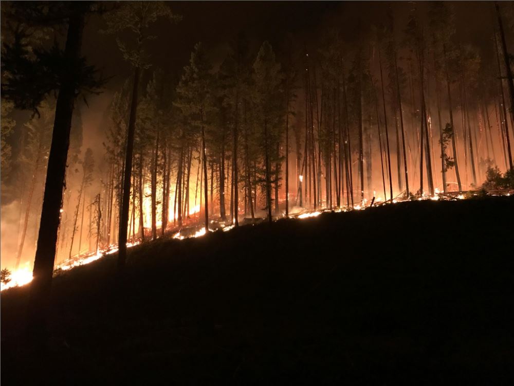
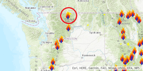
Diamond Creek Fire – Mazama, Washington
The Diamond Creek Fire near Mazama, Washington is a very large wildfire in the Western US that started on Sunday, July 23rd and has grown to more than 128,000 acres! There are nearly 22 people working on this fire, which is 80% contained. The estimated containment date is set for Sunday, October 15th.
“Incident Summary: The Diamond Creek Fire was reported on July 23, 2017 at approximately 9:45 a.m. The fire is burning in the Pasayten Wilderness and Eightmile drainage about 11 miles north of Mazama, Washington. Smokejumpers responded to the fire within two hours of it being reported. However, due to extreme terrain, heavy dead and down timber, and critical fire weather conditions, the fire was unable to be contained during initial response. The fire crossed into Canada on August 29. Fire managers recognized that the Diamond Creek Fire would likely be a long term event. Monitor, confine and point protection strategies are being used inside the Pasayten Wilderness. Outside the wilderness, the fire is being managed under a suppression strategy using a mixture of direct, indirect and point protection tactics when and where there is a high probability of success. Fire personnel will engage the fire at the appropriate time and location, while keeping public and firefighter safety as the top priority. Fire personnel are currently focused on identifying and implementing suppression repair work on the primary and contingency control lines. The suppression repair will not compromise the intended purpose of the control lines should they be needed at a later date.”
(Night time picture of a glowing yurt Credit: Brent Tannehill) 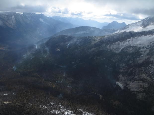
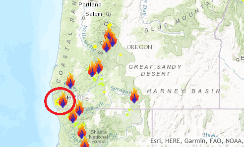
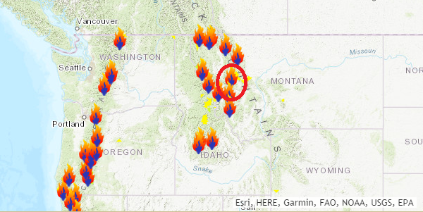
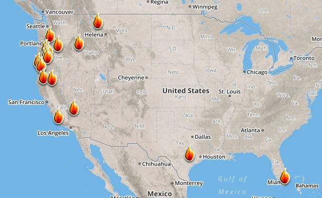
Ongoing Large Wildfires
Here’s a look at the current wildfire map across the country. While several fires are still ongoing, recent cool and somewhat wet weather has been helping curb the wildfire threat, especially in the Western US.
Here’s a list of all the current large wildfires from Inciweb:
National Weather Outlook
Here’s the weather outlook through the middle part of the week, which shows a stalled front across Florida and the Gulf Coast, which will help to bring widespread T-storms to the region, some of which could produce heavy rainfall. There will also be some unsettled weather across the western half of the country, which will bring widely scattered showers and storms across the Plains, while heavy snow will fall again in the mountains.
.gif)
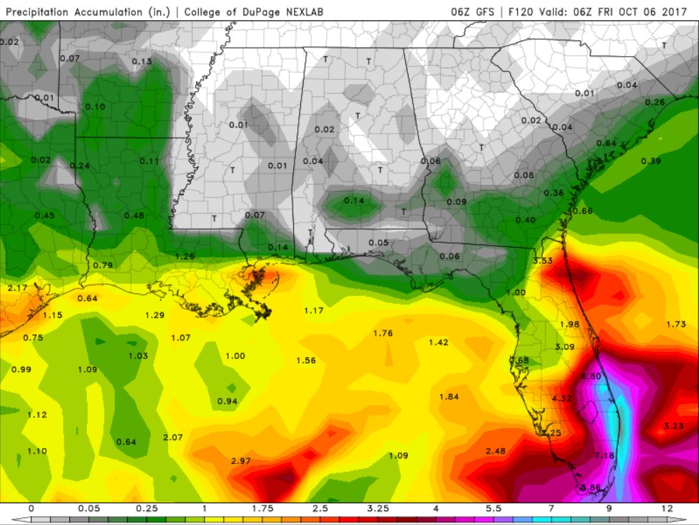
According to NOAA’s WPC, the next several days could produce very heavy rainfall across the Florida and the Gulf Coast with some 2″ to 4″+ tallies possible. There will also be prolonged areas of rain across the Midwest and the Plains. Some areas there could see 2″ to 4″+ through midweek and possibly even more through the end of the week.
.gif)
.png)
By Todd Nelson, filling in for DouglasAhh, October. The month of Pumpkin Spice and orange-colored everything.
My 2 young boys decided to put every Halloween decoration known to man up around the house yesterday. It’s a little much and I’m pretty sure astronauts aboard the International Space Station can now see a strange orange glow as they pass overhead. Happy haunting.
After a soggy Sunday, we don’t get much relief as more showers and storms linger across the region Monday. It still looks like the best chance of isolated strong storms and locally heavy rain rumbles in tonight.
Expect numerous puddles through Tuesday as rainfall tallies approach 1 to 2 inches or more across the state. Latest computer models suggest that sunshine returns for a majority of the 2nd half of the week with temperatures near normal. Not bad if you’re planning any trips for fall color peeping.
According to MN’s DNR, there are areas across the northern parts of the state that are peaking right now. Typical peak in the Twin Cities usually arrives in mid October and it goes fast! Don’t blink.
________________________________________________________________________
_______________________________________________________
This Day in Weather History
October 2nd
1953: A record high of 90 for the St. Cloud area is recorded in 1953 (and later tied in 1992). Minneapolis also sets a record that same day in 1953 with a high of 89 degrees.
1849: Persistent rain at Ft. Snelling accumulates to 4 inches in one and a half days.
________________________________________________________
Average High/Low for Minneapolis
October 2nd
Average High: 65F (Record: 89F set in 1953)
Average Low: 45F (Record: 22F set in 1974)
Record Rainfall: 0.90″ set in 2013
_________________________________________________________
Sunrise/Sunset Times for Minneapolis
October 2nd
Sunrise: 7:12am
Sunset: 6:51pm
Hours of Daylight: ~11 hours 38 mins
Daylight LOST since yesterday: ~3 minutes and 5 seconds
Daylight LOST since summer solstice (June 20th): 3 hours & 59 minutes
__________________________________________________________
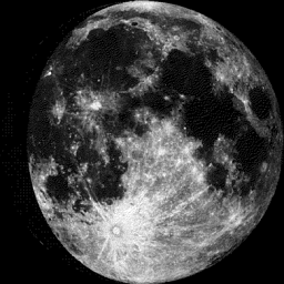
Moon Phase for October 2nd at Midnight
2.5 Days Until Full “Harvest” Moon
“Oct. 5, 2:40 p.m. EDT– Full Harvest Moon. Traditionally, this designation goes to the September full moon that occurs closest to the autumnal (fall) equinox. This year’s Harvest Moon comes unusually late. At the peak of the harvest, farmers can work into the night by the light of this moon. Usually, the moon rises an average of 50 minutes later each night, but for the few nights around the Harvest Moon, the moon seems to rise at nearly the same time each night: just 25 to 30 minutes later across the U.S., and only 10 to 20 minutes later for much of Canada and Europe. Corn, pumpkins, squash, beans and wild rice — the chief staples of Native Americans — are now ready for gathering.”
_________________________
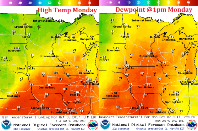
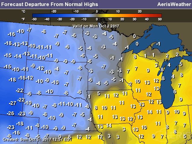
Temps on Monday could sneak up close to 70F across southern Minnesota as the front stalls across the region. Dewpoints will also be a bit higher as some climb to around 60F across the southern part of the state as well.
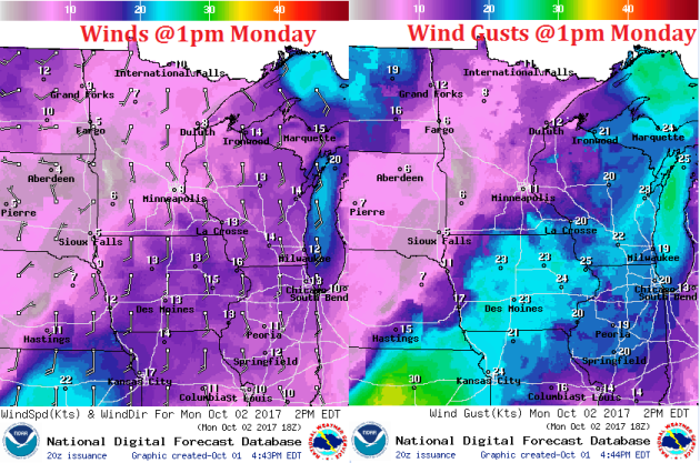
Weather Outlook For Monday
A round of heavier rain will taper a bit early Monday, but another round of heavy showers looks to develop later Monday through early Tuesday.