
Cold Weather Facts You Never Wanted To Know
Here are a few cold weather factoids; numbing nuggets that will all but guarantee you’ll never be asked to talk about the weather again. Winter cold kills roughly twice as many Americans as summer heatwaves. Every year, state and local agencies spend over $2.3 billion on snow and ice removal. And the most common birthday in the United States is September 16th, which means that most babies are conceived during the early winter holiday season.
Who knew? Citations below.
Misery does, in fact, love company. On some primal level it’s reassuring that most of America east of the Rockies is shivering through what may be the coldest outbreak of the winter. A major coastal storm will thrash coastal New England and Canada with near-hurricane-force winds later this week.
Another jab of Nanook air later this week gives way to a tepid weekend warming trend. Models hint at 20s by Sunday, which will feel pathetically good after what we’ve just been through.
According to the National Weather Service the last week of December was the coldest in 132 years at MSP. Impressive.
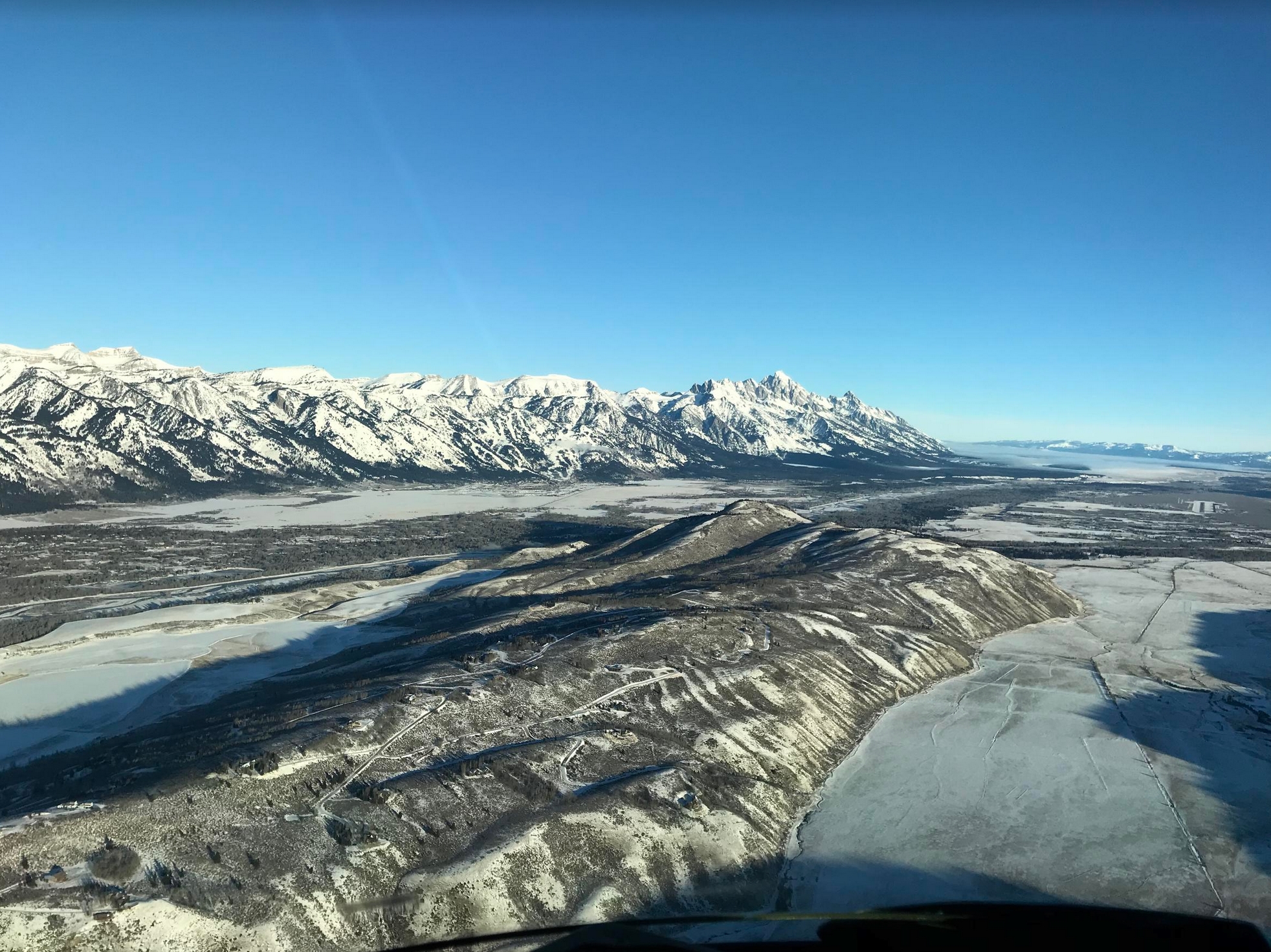
Photo above of Jackson Hole courtesy of Mark Anderson, a private pilot. Notice the runway in the upper right. Thanks Mark!

59 Cold Facts About Winter. Check out some of the (vaguely amazing) factoids about snow and cold from FactRetriever.

Trending Milder. Here is ECMWF (European) guidance for the Twin Cities looking out 15 days, showing 20s, even a chance of 30s by mid-January. Only in Minnesota would this be interpreted as a “warm front”. Graphic: WeatherBell.


Graphic credits above: Praedictix and AerisWeather.

Growing Risk of a January Thaw. GFS 500mb wind forecasts are (consistently) calling for more of a west to east wind flow aloft by mid-January, implying fairly consistent 20s and 30s. Which will feel quite remarkable after the recent cold wave.

Praedictix Briefing: Issued Tuesday, January 2nd, 2018:
* An area of low pressure will form tonight into Wednesday off the eastern Florida coast that will bring wintry precipitation along the East Coast for the middle to end of the week.
* Snow or ice – depending on temperature and precipitation intensity – will start later tonight across northern Florida and southern Georgia – with wintry precipitation spreading into the Carolinas Wednesday. Across the Southeast, snow totals are expected to range from under an inch (across southern portions) to up to 5” across parts of the Carolinas into Virginia.
* The system will continue to strengthen as it moves north along the coast, and will have the potential to bring areas like Boston 5-7” of snow Wednesday Night through Thursday and eastern Maine over a foot of snow Thursday into Friday. This – combined with gusty winds – will cause reduced visibilities and rough travel across the region.

Coastal Low Forming. An area of low pressure is expected to form off the Southeast coast tonight into Wednesday and quickly strengthen as it moves up the East Coast into Thursday. While there is still uncertainty in the overall path of this system, it does currently have the potential to bring snow and ice to parts of the Southeast tonight into Wednesday, with snow spreading into the Northeast Wednesday night. If the storm tracks further west, we could see heavier snow totals unfold across parts of the Northeast than currently is in the forecast. Map credit: NOAA.

Timing Out Precipitation. By tomorrow morning, snow or freezing rain (dependent on temperatures and precipitation intensity) is expected to be falling across parts of northern Florida and southern Georgia with this forming system. As it moves up the east coast, snow will spread across the Carolinas and into southern Virginia by Wednesday evening, then into New England and the Northeast by Thursday morning. Snow will come to an end in the New York City and Boston areas Thursday Night, with snow slowly tapering off across Maine Friday. However, due to the strength of this system, snow (and strong winds) will be possible across a good portion of New England. Map credit: Praedictix, AerisWeather.

Advisories And Watches. Winter Weather Advisories and Winter Storm Watches have already been issued from northern Florida up the east coast to the Boston area ahead of this mid to late week system. Winter Weather Advisories are in effect tonight into Wednesday morning across parts of Florida and Georgia for the potential of either less than an inch of snow or less than a quarter-inch of ice, depending on temperatures and precipitation intensity. Winter Storm Watches have been issued from northern Florida to southeastern Maryland and southern Delaware for the potential of mainly accumulating snow. Snow totals will range from an inch or two across the Southeast, with 3-6” possible across parts of the Mid-Atlantic. Across all of Rhode Island and eastern Massachusetts (including Boston), a Winter Storm Watch is in effect for the potential of 6”+ of snow. I would expect Winter Storm Watches to be extended into Maine later today.

Snowfall Forecast Across The Southeast. Snow totals will range from less than an inch across northern Florida to up to three inches across parts of east-central North Carolina and up to five inches across northern North Carolina and southern Virginia tonight and Wednesday. Most of the snow across the Carolinas will fall along and east of I-95. This snow will have the potential to impact travel and cause reduced visibilities across the region.
NWS Most Likely Snowfall Totals Across The Southeast. Based on NOAA guidance, here are the most likely snowfall totals for more select cities:
Charleston, SC:

Wilmington, NC:

Newport, NC:

Wakefield, VA:


Ice Forecast Across The Southeast. Any ice will be dependent on temperatures and precipitation intensity, but we could see enough in some spots – especially across northern Florida and southern Georgia – to make travel slick and difficult.

Snowfall Forecast Across The Northeast. While only 1-3” of snow is expected at the moment for the Philadelphia and New York City metros, the heaviest snow with this system will be found from Rhode Island to eastern Maine. In Rhode Island and eastern Massachusetts, snow totals of 5-7” are possible, which is why a Winter Storm Watch has been issued for Boston. Across parts of eastern Maine, snow totals could top a foot. Due to the expected later timing of the heavy snow across Maine (and still some uncertainty in the forecast), watches will not be issued by local weather service offices until at least later today. Map credit: Praedictix and AerisWeather.
NWS Most Likely Snowfall Totals Across The Northeast. Based on NOAA guidance, here are the most likely snowfall totals for more select cities:
Philadelphia, PA:

New York, NY:

Boston, MA:

Portland, ME:

Caribou, ME:


Strong Wind Gusts Expected Thursday. Due to the rapid strengthening of this system, strong wind gusts are expected to accompany the snow Thursday (and into Friday as well). We could see wind gusts of 30+ mph Thursday along the east coast, with the strongest winds potentially right along the coast. This will lead to reduced visibility with the falling snow, and could have the potential to lead to blizzard conditions.
Summary: An area of low pressure is expected to form off the eastern Florida coast tonight into Wednesday, quickly strengthening and tracking up the East Coast through the end of the week. This will bring the potential of snow or ice (with plenty of cold air in place) across parts of the Southeast to wake up Wednesday morning. The snow will track north into parts of the Mid-Atlantic by Wednesday Night and into the Northeast by Thursday. Snow totals across the Southeast could range from 1-5” (with higher totals the further north across the region you are into parts of North Carolina and Virginia). Across the Northeast, snow totals of 4-7” will be possible across parts of Rhode Island and Massachusetts, with over a foot possible across eastern Maine. Along with strong winds expected Thursday across the Northeast, this will lead to reduced visibilities and difficult travel conditions.
D.J. Kayser, Meteorologist, Praedictix

Ice Loss and the Polar Vortex: How a Warming Arctic Fuels Cold Snaps. InsideClimate News connects the dots: “…New research shows that some northern regions have been getting hit with these extreme cold spells more frequently over the past four decades, even as the planet as a whole has warmed. While it may seem counterintuitive, the scientists believe these bitter cold snaps are connected to the warming of the Arctic and the effects that that warming is having on the winds of the stratospheric polar vortex, high above the Earth’s surface. Here’s what scientists involved in the research think is happening: The evidence is clear that the Arctic has been warming faster than the rest of the planet. That warming is reducing the amount of Arctic sea ice, allowing more heat to escape from the ocean. The scientists think that the ocean energy that is being released is causing a weakening of the polar vortex winds over the Arctic, which normally keep cold air centered over the polar region. That weakening is then allowing cold polar air to slip southward more often...”
Map credit: “A strong polar vortex (left, from December 2013) is centered over the Arctic. A weakened polar vortex (right, from January 2014) allows cold air to dip farther south.” Credit: NOAA

Only Once Has America Seen More Billion-Dollar Disasters. Bloomberg Quint has the article: “…Among the most devastating events were hurricanes Harvey, Irma and Maria and wildfires in northern California. The killer storms caused economic losses of more than $210 billion in the U.S. and across the Caribbean, and about $100 billion in insured damages, according to Mark Bove, a senior research scientist with Munich Reinsurance America in Princeton, New Jersey. The list goes on — ruinous hail in Colorado and Minnesota, tornado outbreaks across the Midwest and South, flooding that damaged a massive dam in California and triggered evacuations downstream. A lake-effect snowband off Lake Erie dumped 34 inches of snow at Pennsylvania’s Erie International Airport on Christmas Day, quadrupling the previous record from 2002, according to the Weather Channel. A warming climate can bring an increase in lake-effect snow, according to NOAA…”

100 Days On, Puerto Ricans Still Struggle for Power: From Climate Nexus Hot News: “Around half of Puerto Ricans–more than 1.5 million people–remain without power 100 days since Hurricane Maria hit the island, according to official figures released Friday. In the first official figures released by the Puerto Rican government since the storm made landfall in September, officials report one of the island’s 78 municipalities remains totally without power. Gov. Ricardo Rosselló had promised in October to restore 95 percent of power by December 15, while the Army Corps of Engineers estimated power would be totally restored by May. Anger continues to grow as residents continue to struggle with closed schools and businesses and increased health risks. Authorities are grappling with challenges updating and restoring the aged grid and potentially introducing new renewable power.” (Announcement: New York Times $, AP, The Hill. Impacts: AP, NPR, NBC. Grid: Politico Pro $, Washington Examiner).

In All Likelihood, Someday the Sun Will Knock Out the Grid. A story at Popular Science increased my desire to get off the grid: “…Today, modern society relies on exactly the devices that such a storm disrupts. A 2017 study in the American Geophysical Union’s Space Weather journal estimated the effect if a solar storm as great as the largest on record—an 1859 shakeup called the Carrington Event—were to strike again. It would cost the United States $42 billion per day. The repercussions could last years, perhaps decades. The power grid could fail. You wouldn’t be able to get money out of a bank. Businesses couldn’t operate. Water pumps wouldn’t work; phones either. Food would go bad. Governments would have a hard time governing. “We have created an incredible vulnerability, unlike any other,” says Bill Murtagh, program coordinator for the Space Weather Prediction Center, the celestial arm of the National Oceanic and Atmospheric Administration, headquartered in Boulder, Colorado…”
File image: NASA.

Tax Overhaul Leaves Minnesota Clean Energy Future Uncertain. The markets hate regulatory uncertainty. Here’s an excerpt from Associated Press: “…Gregg Mast is the executive director of Clean Energy Economy Minnesota, a nonprofit that represents clean energy businesses. Mast said the uncertainty the new tax law creates is not good for business. He said he’s working with a congressional delegation and business leaders to better understand the impact of the measure on the renewable energy industry and energy efficiency. “It’s early,” Mast said. “I think with a tax bill this large, there’s always an opportunity to come back with a fix bill to address some of those provisions that, perhaps, were not thought of early on.” Wind and solar energy has grown in Minnesota because of the tax credits, and that growth is expected to continue through 2018 because utilities have been planning such expansions for years. But smaller companies might find themselves in a less comfortable position, according to Beth Soholt, executive director of Wind on the Wires...”

2017 Was Safest Year on Record for Airline Passengers. There was some good news last year. Here are a couple of clips from The Independent: “In a year when more people flew to more places than ever, 2017 was the safest on record for airline passengers. The Dutch-based aviation consultancy, To70, has released its Civil Aviation Safety Review for 2017. It reports only two fatal accidents, both involving small turbo-prop aircraft, with a total of 13 lives lost. No jets crashed in passenger service anywhere in the world…The report warns that electronic devices in checked-in bags pose a growing potential danger: “The increasing use of lithium-ion batteries in electronics creates a fire risk on board aeroplanes as such batteries are difficult to extinguish if they catch fire. “Airlines worldwide are training their crews to fight any fires in the cabin; the challenge is keeping such batteries out of passenger luggage.” In 2016, 271 people lost their lives in seven fatal events…”

Robots Are Going to Turbocharge One of Society’s Biggest Problems. Quartz explains: “…On the flip side, it warned that automation will widen the pay gaps for women and minorities since robots are likely to phase out lower-skilled jobs over the next few decades, and the jobs created in their place will be more highly skilled. Low-wage jobs are five times more likely to be automated than higher paid jobs, according to the report. “Automation risks increasing gender and race inequality,” says IPPR, noting that women and some minority groups are more likely to work in low-skill, “automatable” occupations. “The impact on inequality will depend on the skill-level of new jobs created and individuals’ ability to access opportunities…”

Best Cities for Beer Lover? Duluth ranks third in the USA, details from SmartAsset: “Sometimes when it comes to beer quantity is more important than quality. For beer drinkers who follow that philosophy Duluth is probably a good place to stumble into. Duluth has 31 bars per 100,000 residents and 10.4 breweries per 100,000 residents. That means plenty of options for where to get a brew. Best of all, a night out on the town won’t run your savings account dry in Duluth. Our data shows the average pint of draft beer in Duluth costs only $2…”

Man’s Obituary Blames Cleveland Browns Winless Season as Cause of Death. AP reports: “An Ohio man’s tongue-in-cheek obituary blames the winless Cleveland Browns for contributing to his demise. The obituary published in the Sandusky Register says Paul Stark, of Huron, died Wednesday at a hospice facility after a brief illness “exacerbated by the hopeless condition of the Cleveland Browns.” The football team was 1-15 last season and 0-15 this year ahead of Sunday’s finale at Pittsburgh...”
Trace of snow fell in the Twin Cities yesterday.
13 F. high yesterday at Twin Cities International Airport.
24 F. average high on January 2.
33 F. maximum temperature on January 2, 2017.


WEDNESDAY: Partly sunny. WC: -15F. Winds: NW 8-13. High: 5
WEDNESDAY NIGHT: Mostly clear and nippy. Low: -9
THURSDAY: Plenty of sun. Bug count remains low. Winds: NW 3-8. High: 3
FRIDAY: Blue sky. Hard to get out of bed. Winds: NW 5-10. Wake-up: -10. High: 4
SATURDAY: Clouds increase, stiff breeze. Winds: S 10-20. Wake-up: -5. High: 17
SUNDAY: Mostly cloudy, almost tolerable. Winds: NW 5-10. Wake-up: 12. High: 26
MONDAY: Chance of light snow or flurries. Winds: SW 7-12. Wake-up: 17. High: 20
TUESDAY: Patchy clouds, above average temps. Winds: SW 5-10. Wake-up: 18. High: 27
Climate Stories…

Science Says: Why There’s a Big Chill in a Warming World. Seth Borenstein explains for The Associated Press: “…This is an area of hot debate and research among scientists and probably is a mix of human-caused climate change and natural variability, said Furtado. Climate change hasn’t made the polar vortex more extreme, but it probably is making it move more, which makes the weather seem more extreme, he said. A recent study by Potsdam Institute climate scientist Marlene Kretschmer found the polar vortex has weakened and meandered more often since 1990, but that study focused more on Europe. Ongoing research shows that there seems to be a similar connection for more frequent Arctic cold snaps like what the U.S. is now experiencing, Kretschmer said. Don’t confuse weather — which is a few days or weeks in one region — with climate, which is over years and decades and global. Weather is like a person’s mood, which changes frequently, while climate is like someone’s personality, which is more long-term, Furtado said…”
Photo credit: “Chris McGuire tries to stay warm as he waits for a space at the City Rescue Mission on Tuesday, Jan. 2, 2018, in Jacksonville, Fla. Dangerously cold temperatures blamed for several deaths have wreaked havoc across a wide swath of the U.S., freezing a water tower in Iowa, halting ferry service in New York and leading officials to open warming centers even in the Deep South.” (Will Dickey/The Florida Times-Union via AP).

It’s Cold Outside, But That Doesn’t Mean That Climate Change Isn’t Real. USA TODAY explains the difference between “weather” and “climate”: “…But there’s a big difference between weather and climate, scientists say: Weather happens in the short term, while global climate systems influence weather over longer time scales. Daily or weekly weather patterns “say nothing about longer term climate change,” said J. Marshall Shepherd, director of the atmospheric sciences program at the University of Georgia and a former president of the American Meteorological Society. “The clothes that you have on today do not describe what you have in your closet but rather how you dressed for today’s weather. The range of clothing that you have in your closet is climate,” Shepherd said in an email...”

Hurricanes and Heat Waves: Stark Signs of Climate Change “New Normal”. Here’s a clip from a story at The Guardian: “…Eight states – Arizona, New Mexico, Florida, Georgia, North Carolina, South Carolina, Virginia and West Virginia – have in fact experienced record warmth for the first 11 months of the year. A national record, however, is out of reach due to the lack of an El Niño, a periodic climatic event that appeared last year and spurred extra heat. But the fingerprint of climate change extends beyond just temperature. California’s deepest drought on record was broken by intense rainfall at the start of the year, an example of the long dry spells interrupted by ferocious downpours that scientists say are becoming more frequent in a warming world. To the north, Arctic sea ice reached a record low wintertime maximum extent as, incredibly, temperature instruments in Alaska malfunctioned due to the surging warmth…”

Three 2016 Weather Extremes “Not Possible” Without Human Warming. Yale Climate Connections reports: “For the first time, an annual report issued by the American Meteorological Society has found that the extreme magnitudes of three weather events in 2016 “was not possible without the influence of human-caused climate change. ” Explaining Extreme Events of 2016 from a Climate Perspective, published as a supplement to the Bulletin of the American Meteorological Society (BAMS), is AMS’s sixth annual report on extreme weather events. It was officially released and presented on December 13 at the American Geophysical Union’s fall meeting in New Orleans. The report includes 27 peer-reviewed scientific papers. Authors of those papers examined 21 different extreme weather events around the globe in 2016 – including wildfires in North America and Australia, droughts in South Africa and Brazil, cold snaps in Eastern China, and an anomalous body of warm water in the Pacific Ocean...”

What the World Will Look Like 4C Warmer. Here’s a clip from a story at Big Think: “Micronesia is gone – sunk beneath the waves. Pakistan and South India have been abandoned. And Europe is slowly turning into a desert. This is the world, 4°C warmer than it is now. But there is also good news: Western Antarctica is no longer icy and uninhabitable. Smart cities thrive in newly green and pleasant lands. And Northern Canada, Scandinavia and Siberia produce bountiful harvests to feed the hundreds of millions of climate refugees who now call those regions home. This map, which shows some of the effects a 4°C rise in average temperature could have on the planet, is eight years old, but it seems to get more contemporary as it ages (and the planet warms)...”

How Big Oil Lost Control of its Climate Misinformation Machine. InsideClimate News explains: “…Heartland’s rebound is striking. Its ascent into the Trump administration’s orbit, where it now advises the Environmental Protection Agency on climate change issues, marks the most dramatic success yet in a decades-long crusade, first funded by fossil fuel money, against the mainstream scientific conclusion that human activity is warming the planet and inviting disastrous consequences. Hundreds of millions of dollars from corporations such as ExxonMobil and wealthy individuals such as the billionaires Charles and David Koch have supported the development of a sprawling network, which includes Heartland and other think tanks, advocacy groups and political operatives. They have cast doubt on consensus science, confused public opinion and forestalled passage of laws and regulations that would address the global environmental crisis. It is one of the largest, longest and most consequential misinformation efforts mounted against mainstream science by an industry. Climate denial, thanks to the network’s influence, has become a core message of the Republican Party, now in control of the White House and Congress...”
On It’s 100th Birthday in 1959, Edward Teller Warned the Oil Industry About Global Warming. The Guardian has details.

Nine Reasons To Be Optimistic About Climate Change in 2018. VICE.com has a long list, including this: “…The vast majority of vehicles on today’s roads are still run by gas and diesel. But there were many signs in 2017 this could quickly change. It wasn’t just that Volvo announced plans to only sell electric vehicles and hybrids by 2019. Nor that China, as I noted earlier, will be banning gas-powered cars. There is an emerging consensus among followers of the industry that the entire auto business model is radically changing—shifting from privately owned cars to fleets of robot-driven electric vehicles hailed on your phone. “It saddens me to say it,” acknowledged the former vice chairman of General Motors Bob Lutz in an article for Automotive News, “but we are approaching the end of the automotive era…”
