.gif)
Atlantic Outlook Next 5 Days
.png)
.png)
___________________________________________________________
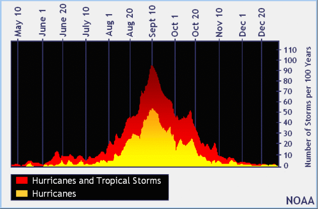
It certainly has been a fairly active first half of 2017 with 1390 preliminary tornado reports through October 4th. Note that this is the most tornadoes through that date since 2011, when there were 1,796 reports. The map below shows the distribution of the tornadoes so far this year.
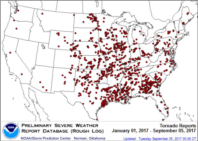
PRELIMINARY 2017 Tornado Count
According to NOAA’s SPC, the PRELIMINARY 2017 tornado count is 1390 (through October 4th). Note that is the most active year for tornadoes since 2011, when there were 1,796 tornadoes. Keep in mind there was a major tornado outbreak in the Gulf Coast region from April 25-28, 2011 that spawned nearly 500 tornadoes, some of which were deadly. That outbreak is known as the Super Outbreak of 2011 and has gone down in history as one of the biggest, costliest and one of the deadliest tornado outbreaks in history.
.png)
_____________________________________________________________________
National Weather Hazards Ahead…
1.) Heavy rain from the Gulf Coast to the Ohio Valley and Mid-Atlantic, Sun-Mon, Oct 8-Oct 9.
2.) Heavy rain across portions of the Mid-Atlantic and Northeast, Tue, Oct 10.
3.) High winds across portions of the Southeast and the Lower Mississippi Valley, Sun, Oct 8.
4.) High significant wave heights for coastal portions of the Gulf Coast, Sun, Oct 8.
5.) Heavy snow across portions of the Central and Northern Plains, Mon, Oct 9.
6.) High winds across portions of the Central Great Basin and California, Sun-Mon, Oct 8-Oct 9.
7.) High winds across portions of the the Northern Plains and the Northern Rockies, Sun, Oct 8.
8.) Flooding possible across portions of the Upper Mississippi Valley and the Northern Plains.
9.)Flooding occurring or imminent across portions of the Southeast and the Southern Plains.
Flooding likely across portions of the Northern Plains.
10.) Slight risk of much below normal temperatures for portions of California and the Pacific Northwest, Fri-Sat, Oct 13-Oct 14.
11.) Severe Drought across the Central Plains, the Northern Plains, Hawaii, the Northern Rockies, the Middle Mississippi Valley, and the Upper Mississippi Valley.
.png)
_________________________________________________________
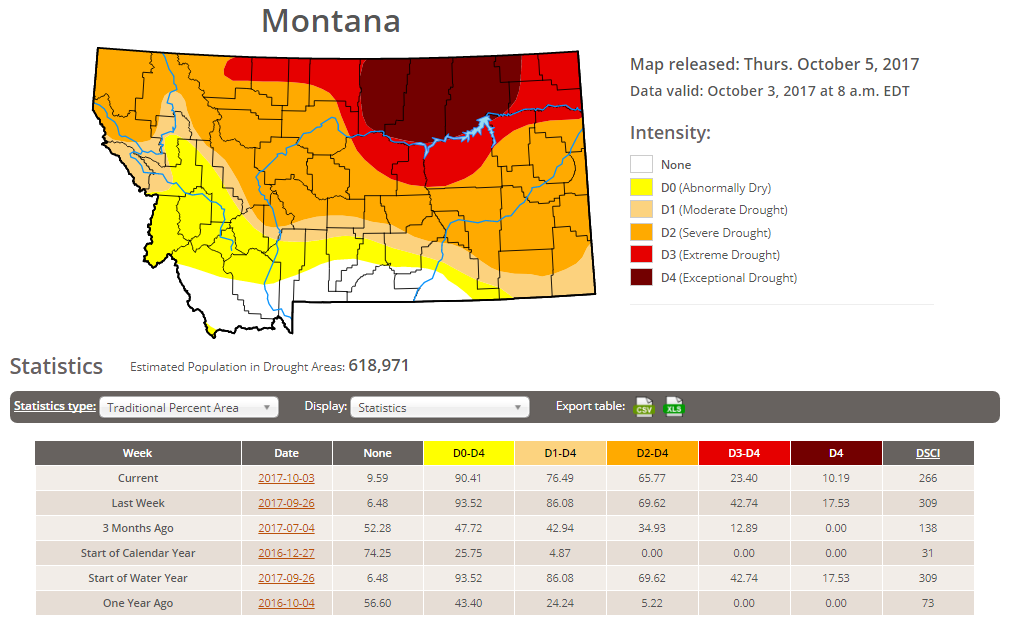
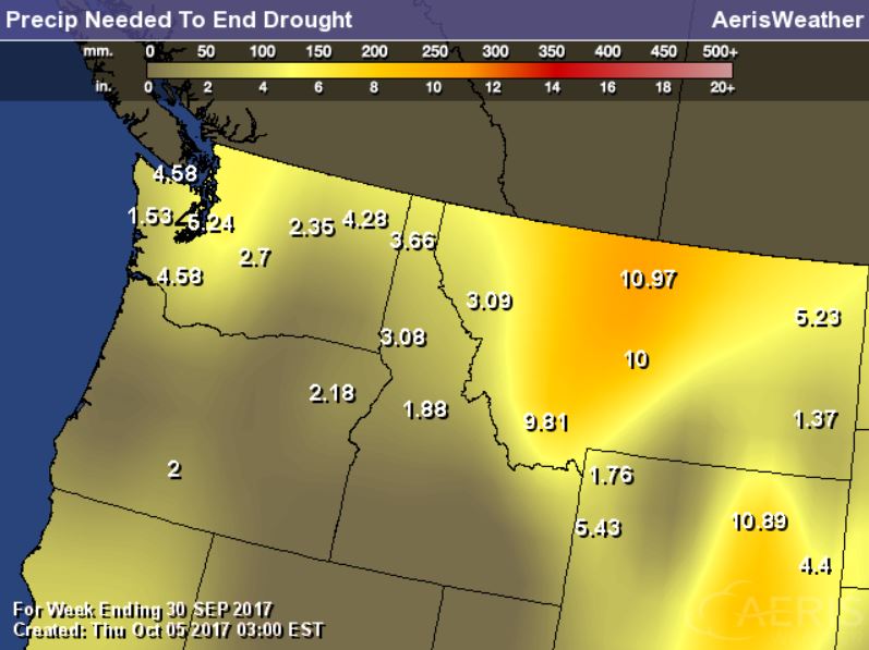
Latest Drought Monitor
Here’s the latest drought update from the US Drought Monitor, which shows EXCEPTIONAL drought conditions continuing across parts of Montana. Note that nearly 90% of the state is considered to be abnormally dry, but the EXCEPTIONAL drought covers nearly 10% of the state, which is down from nearly 18% from last week. In North Dakota, less than 1% is in an EXCEPTIONAL drought, but nearly 3% of the state is still in an EXTREME drought, which is also the same as last week.
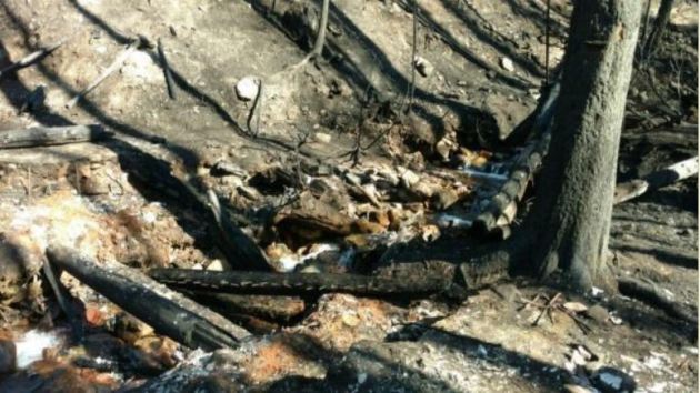
Rice Ridge Fire – 1.4 Miles NE of Seeley Lake, MT
The Rice Ridge Fire near Sleeley Lake, MT is another very large wildfire that started on Monday, July 24th due to lightning. The fire has grown to more than 160,000 acres and is 95% contained. There are 37 people working on the fire and they hope to have it fully contained by Sunday, October 15th.
“The Northern Rockies Wildland Fire Management Team is transitioning with the local Type 3 organization Tuesday Oct 3 at 6 p.m. Remaining operations will be managed by Phil Shilmerdine, Incident Commander. The Rice Ridge Fire was detected on July 24, 2017. It grew to the current size of over 160,000 acres. With a change of the weather and the onset of fall, fire activity has significantly slowed although firefighters and engines continue to patrol and cool hot spots that are near the fire’s edge. The perimeter in the Scapegoat and Bob Marshall Wildernesses are continually monitored for heat and fire activity.”
(Image Credit: Inciweb – taken on 10/3/2017)
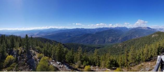
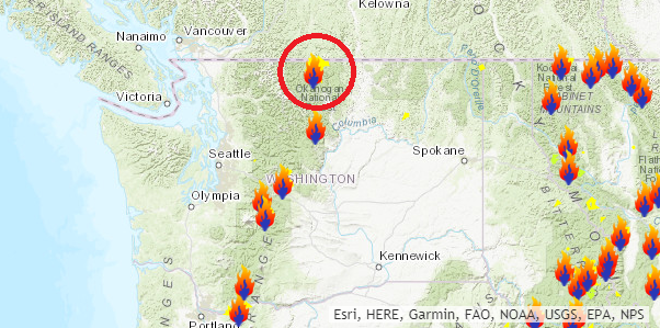
 Diamond Creek Fire – Mazama, Washington
The Diamond Creek Fire near Mazama, Washington is a very large wildfire in the Western US that started on Sunday, July 23rd and has grown to more than 128,000 acres! There are nearly 19 people working on this fire, which is 85% contained. The estimated containment date is set for Sunday, October 15th.
“Incident Summary: The Diamond Creek Fire was reported on July 23, 2017 at approximately 9:45 a.m. The fire is burning in the Pasayten Wilderness and Eightmile drainage about 11 miles north of Mazama, Washington. Smokejumpers responded to the fire within two hours of it being reported. However, due to extreme terrain, heavy dead and down timber, and critical fire weather conditions, the fire was unable to be contained during initial response. The fire crossed into Canada on August 29. Fire managers recognized that the Diamond Creek Fire would likely be a long term event. Monitor, confine and point protection strategies are being used inside the Pasayten Wilderness. Outside the wilderness, the fire is being managed under a suppression strategy using a mixture of direct, indirect and point protection tactics when and where there is a high probability of success. Fire personnel will engage the fire at the appropriate time and location, while keeping public and firefighter safety as the top priority. Fire personnel are currently focused on identifying and implementing suppression repair work on the primary and contingency control lines. The suppression repair will not compromise the intended purpose of the control lines should they be needed at a later date.”
(Night time picture of a glowing yurt Credit: Brent Tannehill)
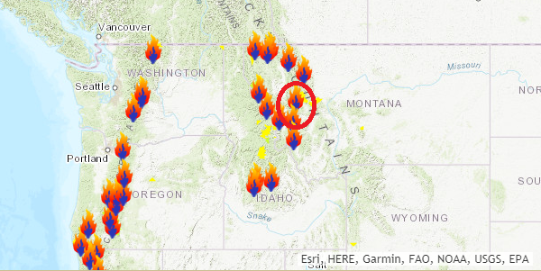
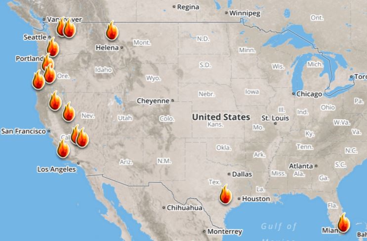
Ongoing Large Wildfires
Here’s a look at the current wildfire map across the country. While several fires are still ongoing, recent cool and somewhat wet weather has been helping curb the wildfire threat, especially in the Western US.
Here’s a list of all the current large wildfires from Inciweb:
National Weather Outlook
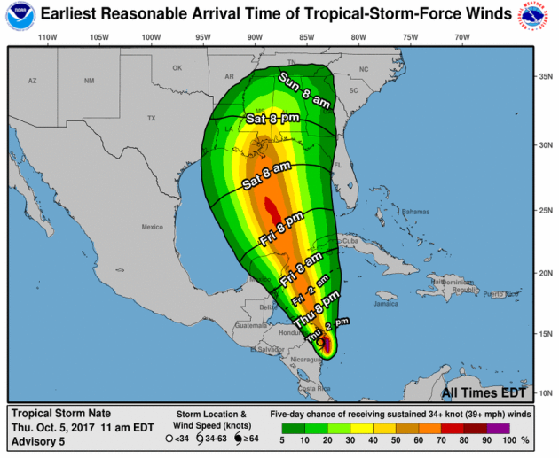
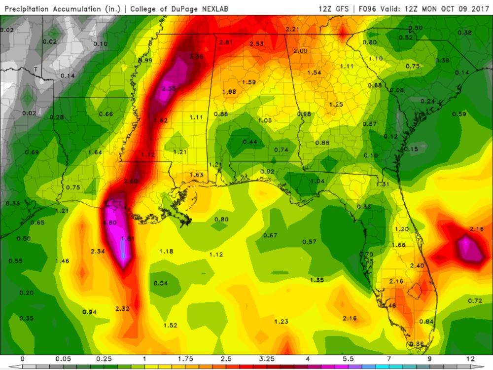
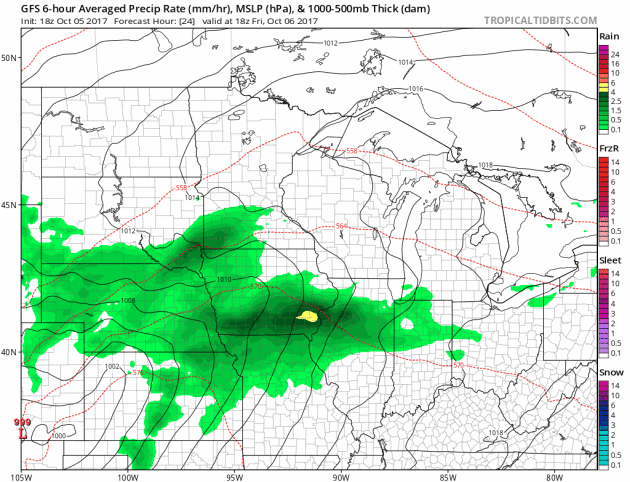
Here’s the weather outlook into the weekend, which shows areas of heavy rain across parts of the Midwest, while NATE moves into the Gulf Coast region with strong winds, heavy rain and coastal flooding.
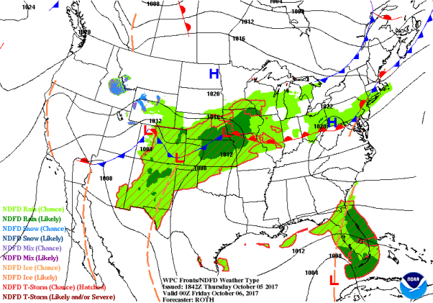
According to NOAA’s WPC, the next several days could produce very heavy rainfall across parts of the Midwest and from NATE as it lifts north from the Gulf Coast to the Northeast. Widespread 2″ to 4″ can be expected, but heavier amounts can’t be ruled out.
.gif)
.png) ________________________________________________________________________
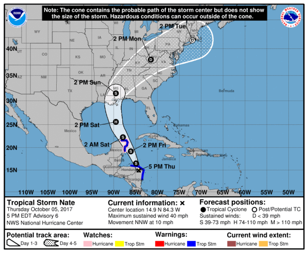
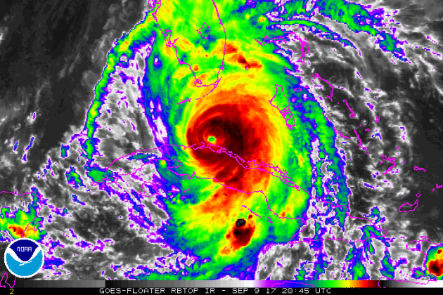
________________________________________________________________________By Todd Nelson, filling in for DouglasThanks to the likes of Harvey, Irma, Jose, Lee and Maria the Atlantic Basin recently ended its 3rd longest stretch of named storm days at nearly 38.
It was an impressive run and things are heating up again after a brief lull in activity. NATE is on track to impact the Gulf Coast as a hurricane late this weekend. There is still some uncertainty on the exact landfall and strength, but latest models are converging on a potential category 1 storm making landfall near Louisiana on Sunday.
Meanwhile, a months worth of rain has already fallen across parts of Minnesota this month and more is on the way. Another slop-tober storm will soak parts of the state with more than 1 inch of rain Friday and early Saturday.
Skies brighten later Saturday and much of Sunday, which will give you a chance to do some fall color peeping. According to the MN DNR, colors are peaking across the northern half of the state and should soon follow here in the metro.
Next weeks cold front could feature more widespread frost up north. Stay tuned!
________________________________________________________________________
_______________________________________________________
This Day in Weather History
October 6th
1997: Hail, wind, and an F0 tornado are reported in the early morning hours in several counties in west central Minnesota. Near Canby in Yellow Medicine County, hail combined with wind gusts nearing 60 mph damage the roof of a bus garage, elementary school windows and a school vehicle. Renville, McLeod, Carver, Scott, and Dakota counties also receive hail and strong winds. Widespread pea to marble size hail accumulates to three inches deep in several areas, and crops are severely damaged over a large part of Renville county. Many power lines and trees are blown down. Southeast of Bird Island, a barn collapses and kills over 100 pigs. Near Brownton in McLeod County, hail accumulates to a depth of 3 inches with one foot drifts. A brief tornado touches down near Stewart in McLeod County, damaging a few trees.
1987: Snow falls over the Arrowhead region.
________________________________________________________
Average High/Low for Minneapolis
October 6th
Average High: 63F (Record: 87F set in 2007)
Average Low: 43F (Record: 25F set in 1873)
Record Rainfall: 1.69″ set in 1941
Record Snowfall: Trace set in 2005
_________________________________________________________
Sunrise/Sunset Times for Minneapolis
October 6th
Sunrise: 7:17am
Sunset: 6:44pm
Hours of Daylight: ~11 hours 26 mins
Daylight LOST since yesterday: ~3 minutes and 5 seconds
Daylight LOST since summer solstice (June 20th): 4 hours & 11 minutes
__________________________________________________________
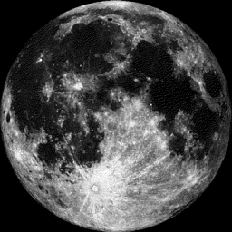
Moon Phase for October 6th at Midnight
1.5 Days After Full “Harvest” Moon
“Oct. 5, 2:40 p.m. EDT– Full Harvest Moon. Traditionally, this designation goes to the September full moon that occurs closest to the autumnal (fall) equinox. This year’s Harvest Moon comes unusually late. At the peak of the harvest, farmers can work into the night by the light of this moon. Usually, the moon rises an average of 50 minutes later each night, but for the few nights around the Harvest Moon, the moon seems to rise at nearly the same time each night: just 25 to 30 minutes later across the U.S., and only 10 to 20 minutes later for much of Canada and Europe. Corn, pumpkins, squash, beans and wild rice — the chief staples of Native Americans — are now ready for gathering.”
_________________________
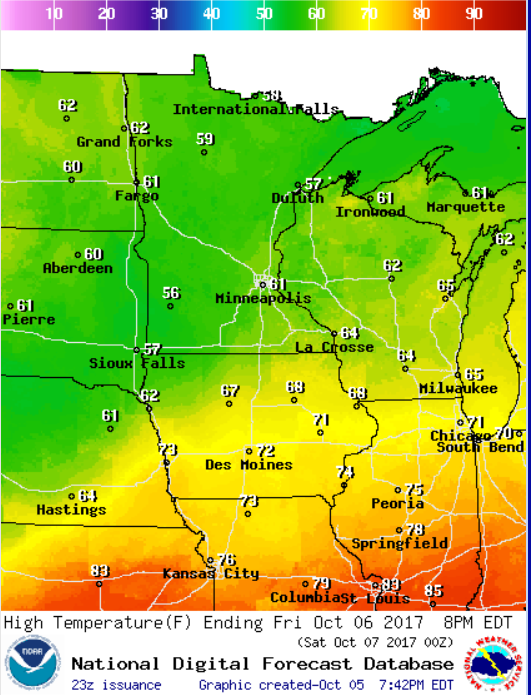
Temps on Friday will be a little cool for this time of the year as readings warm into the upper 50s and low 60s across much of the state.
.png)
______________________________________________________
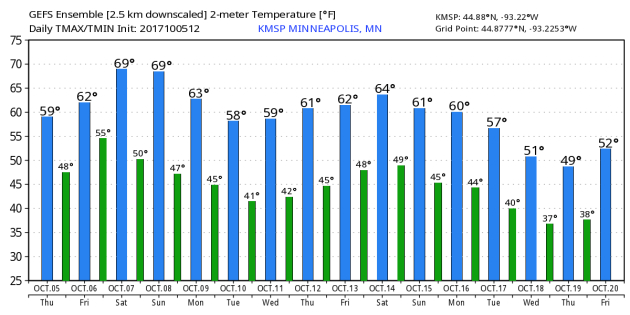
Here’s the temperature outlook through October 20th, which shows temps closer to average through the the middle par of October. However, we’re getting indications of a cooling trend by the end of the month as we fall into 50s.
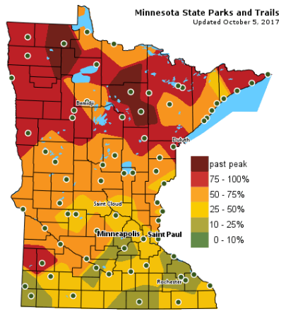
According the MN DNR, much of the state is starting to see hints of fall color, however, much of northern Minnesota is peaking right now with pockets of past peak colors!
Follow along as the fall colors change with the MN DNR map HERE:
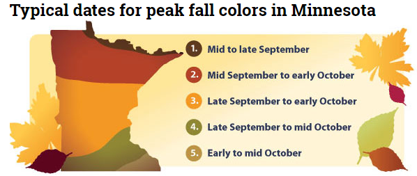
Typical Fall Color Peak in Minnesota
Here are the typical fall color peak times across the state of Minnesota and note that areas along the northern tier of the state usually see their peak toward the 2nd half of September. However, peak color usually doesn’t arrive in central Minnesota until October, but we’re getting close.
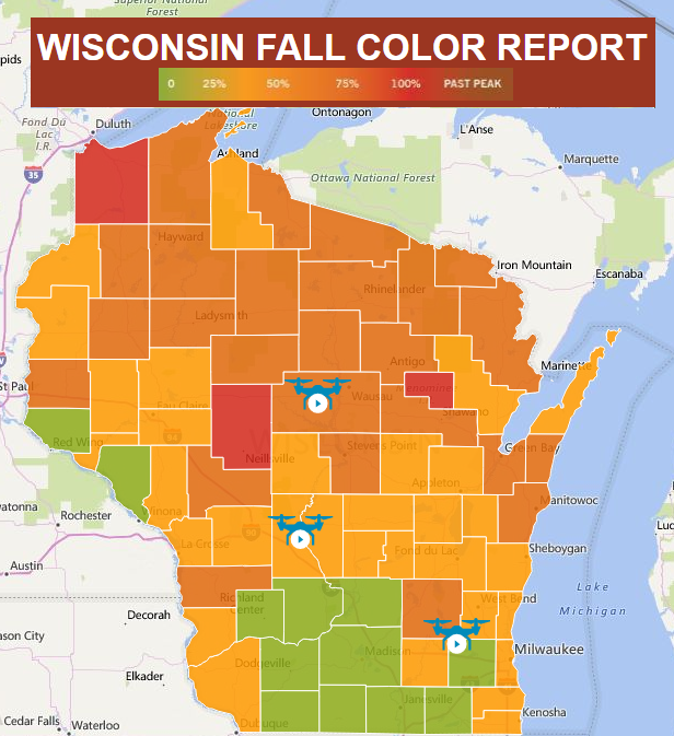
Wisconsin Fall Color Update
We’re also seeing quite a bit of color show up across the northern half of Wisconsin with many locations now nearing 50%-100% color!
See more from Travel Wisconsin HERE:
_________________________________________________________________
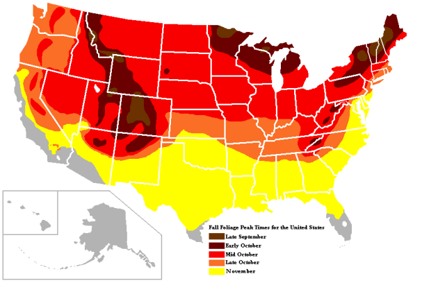
Typical Fall Color Times Across the Country
Here are the typical fall color peak times across the country, which suggests that much of the peak across the northern half of the nation usually wraps up through the month of October.
_____________________________________________________________________

______________________________________________________________

_____________________________________________________________________
_____________________________________________________________________

_________________________________________________________________

_______________________________________________________________
_________________________________________________________

___________________________________________________________________
Thanks for checking in and don’t forget to follow me on Twitter @TNelsonWX

