1990: Nine inches of rain fell over the next two days in Duluth, washing out a million dollars worth in roads.
1982: 77 mph winds were reported in Anoka County.
All or Nothing
The haves have more, the have-nots have less!
A socialist screed?
No, I’m talking about moisture. Dry areas are getting drier, wet regions are getting even wetter, with rain falling harder & faster. Yesterday over 4 inches of rain soaked Onamia, Minnesota; nearly 5 inches in Price, Wisconsin. Typical for June, but early September? The simple fact: there’s more water vapor floating overhead, priming the pump for more intense summer rains, which are now spilling over into meteorological autumn.
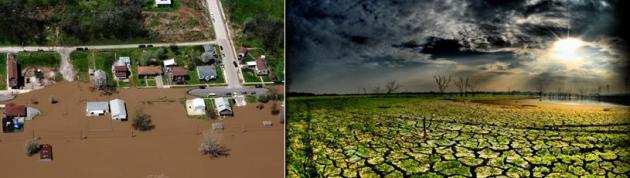
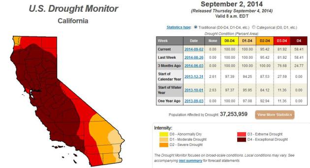
While we navigate lush greenery and jungle-like humidity California is beyond parched.In today’s blog below: a link to a USA Today article claiming that more of the west has been in persistent drought for the last 15 years than any time since the 1150s and 1160s – about 850 years ago. Crazy extremes.
Canadian exhaust whips up behind yesterday’s thundery front, dropping temperatures into the 60s today. Football weather. Winds ease over the weekend under a flawless-blue sky with highs poking into the mid-70s and half as much water in the air than we endured yesterday.
Soak up any lukewarm breezes, maybe take another dip in a favorite lake, because ECMWF (European) data hints at highs in the 50s late next week. Oh boy.
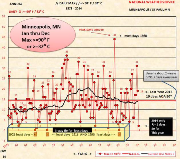
Fewest 90-Degree Days Since 1993. Only 2 days above 90F so far in 2014, and although there’s a slight chance of hitting 90F later this month, odds are against it. That’s the fewest days at or above 90F in 11 years, according to the Twin Cities National Weather Service: “A message from the Minnesota State Climatologist toda got us wondering what does the chart look like for these. The message said “It appears quite possible that we’ll complete 2014 with only two days where the MSP max temp => 90F. Summertime temperature data for the MSP threaded record reaches back to 1873. In those 142 years there are nine years where the number of 90-degree days is two or less…”
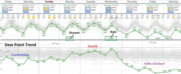
AAA Weekend – HInts of October Late Next Week? Long-range European guidance shows mid-70s this weekend with brilliant sunshine both days and reasonable humidity levels. The best chance of rain comes Wednesday, followed by serious sweatshirt weather late next week. 50s for highs? Lows near 40F. Not ready for this. MSP Meteogram: Weatherspark.
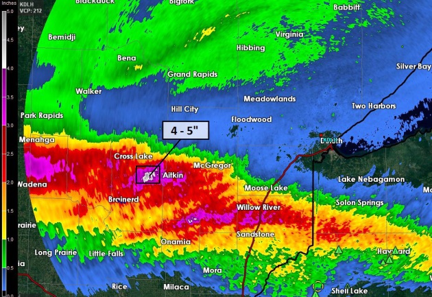
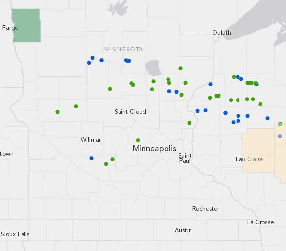
September Monsoons. It was a June flashback, dew points surging into the 70s, fueling severe storms rippling along a slow-moving warm front. Doppler radar estimates suggest 4-5″ rains northeast of Brainerd; 3″+ amounts fro near Wadena to Aitkin and Sandstone.
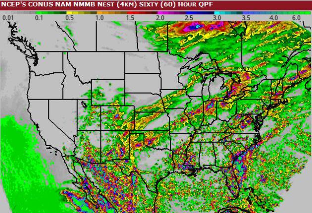
60-Hour Rainfall Potential. Flash flooding is possible near South Bend, New Orleans and Savannah, based on 4 KM NAM guidance. Graphic: NOAA and HAMweather.
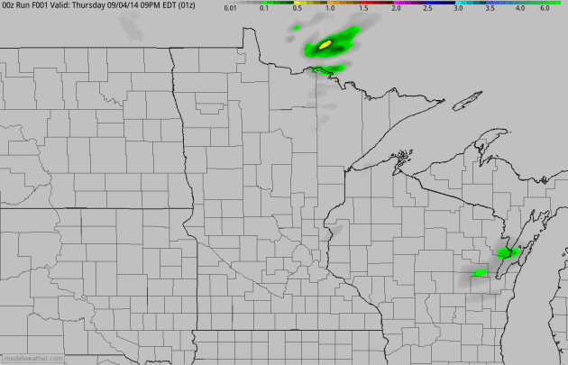
Umbrella Optional. NAM guidance shows showers and T-storms pushing across Wisconsin and Iowa today, but with the exception of instability rain showers over the Arrowhead Minnesota dries out today with a BIG drop in dew point, tumbling from 70s into the 40s, a whiff of what’s to come. Guidance: HAMweather.

August Weather Recap. Here’s a clip from a good summary of recent weather trends, courtesy of The Minnesota DNR:
- August precipitation totals were highly variable across Minnesota. Rainfall totals were below historical averages in far northern Minnesota and some central Minnesota counties. Conversely, monthly rainfall totals were well above average in portions of west central, north central Minnesota, and some southeastern Minnesota locations.
- Average monthly temperatures for August in Minnesota were very near historical averages. As was the case throughout the summer, 90-degree temperatures were infrequent during the month of August.
- In spite of the dry July and early August, seasonal precipitation totals since April 1 remain above historical averages nearly everywhere in Minnesota. For large portions of the state, season-to-date precipitation totals rank above the 95th percentile when compared with the historical database for the April-through-August time period.


See It: Powerful Tornado Passes Through Russian Home. With webcams, dashcams and security cameras we have a nearly continuous visual record that didn’t exist 5-10 years ago. Here’s a link to some remarkable footage from 2013, courtesy of The New York Daily News: “An amazing dash-cam video shows a destructive tornado passing through a Russian community last year. The one-minute-long online video shows the calmness before the storm begins to pick up its power. The footage was taken from inside a vehicle that was parked in the Russian community of Baschkirien and was captured on March 1, 2013...”

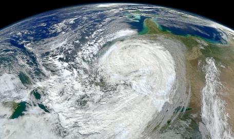
A Storm Worse Than Superstorm Sandy? Although rare, Category 3-4 strength hurricanes have been observed as far north as the New York City area, according to a story at The Asbury Park Press; here’s the intro: “What could be worse than superstorm Sandy? Try the September 1821 hurricane, which hit Cape May and headed north – close to the route of today’s Garden State Parkway – before striking New York, according to our archives. The Category 3 or 4 hurricane packed top sustained winds of 135 mph, according to estimates by the National Weather Service office in Upton, N.Y...” (Image: NASA).

6 Things The Happiest Families All Have In Common. The Week takes a crack at exploring what happy, generally contented families seem to share; here’s an excerpt: “…Research shows whether a kid knows their family history was the number one predictor of a child’s emotional well-being. Here’s Bruce:
And research confirms that meaning in life is all about the stories we tell ourselves…”


TODAY: Mix of clouds and sun. Dew point: 46. Winds: NW 10+ High: 68
FRIDAY NIGHT: Clearing and cool. Low: 50
SATURDAY: Sunny, beautiful. Dew point: 45. Winds: NW 8. High: 75
SUNDAY: Sunny, still postcard-worthy. Wake-up: 53. High: 77
MONDAY: More clouds, isolated shower possible south. Wake-up: 55. High: 75
TUESDAY: Some sun, clouds increase. Wake-up: 60. High: 76
WEDNESDAY: Showers, possible T-storms. Wake-up: 58. High: 69
THURSDAY: Mostly cloudy, risk of sweatshirts. Wake-up: 49. High: 59
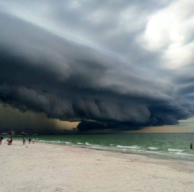
Shelf Cloud. Thanks to Russ Latimer, who captured an impressive shelf cloud sparked by rain-cooled downdrafts in a strong thunderstorm. When you see a cloud formation like this it might be a good day to get off the beach. Just saying…
Climate Stories…
“There is a sufficiency in the world for man’s need but not for man’s greed”. ~Mohandas K. Gandhi
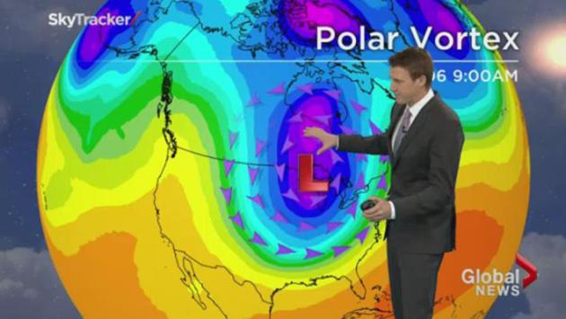
New Study Links Polar Vortex to Climate Change. So maybe it hasn’t been my imagination, after all. Here’s new research suggesting rapid warming of the arctic and far northern latitudes may be impacting the speed and configuration of the jet stream, which in turn impacts weather patterns below, courtesy of Slate’s Future Tense: “…New research published Tuesday in the journal Nature Communications attempts to track the polar vortex disturbances back to their source. The study, written by a team of Korean and American scientists, is the latest (and perhaps most comprehensive) attempt to answer a question that’s as hot as any in climate science right now: What’s the impact of melting Arctic sea ice on extreme weather? Through a blend of statistical analysis of recent weather and computer modeling of a world in which rapid Arctic ice loss hadn’t occurred, the study establishes a link between the warming ocean, melting ice, and weakened polar vortex..”

99.999% Certainty Humans Are Driving Global Warming: New Study. Here’s an excerpt from The Conversation: “There is less than 1 chance in 100,000 that global average temperature over the past 60 years would have been as high without human-caused greenhouse gas emissions, our new research shows. Published in the journal Climate Risk Management today, our research is the first to quantify the probability of historical changes in global temperatures and examines the links to greenhouse gas emissions using rigorous statistical techniques…”
Image credit above: “A new study finds overwhelming odds that humans have contributed to higher global temperatures – so how much are we willing to gamble that it’s wrong?” Kraevski Vitaly/Shutterstock

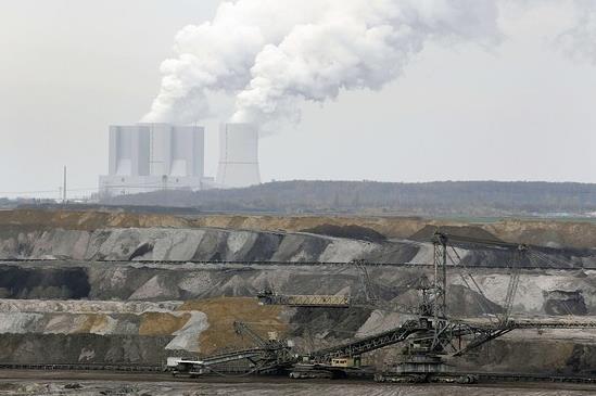
Yale Asks Managers to Weight Climate Change Risks. The Wall Street Journal has the story – here’s an excerpt: “…Mr. Swensen is now urging managers to take into account “the effects of climate change on the businesses in which they are or might be investing,” according to a statement from Yale President Peter Salovey. The endowment office is also asking managers to “anticipate possible future regulatory actions in response to the externalities produced by the combustion of fossil fuels…”
Photo credit above: Reuters/Michaela Rehle.
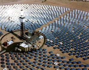
Innovation Key to Climate Change Swerve. Here’s a snippet of a worthy-read at Huffington Post: “…Innovators, businesses, governments and public opinion come together to create adaptations that will shift a trend away from disaster. As described in an excellent New York Times op-ed piece by Robert Jay Lifton, this shift or “swerve” is a “major historical change in consciousness that is neither predictable nor orderly.” Lifton compares the climate change swerve that’s happening now to the nuclear swerve that shifted us during the Reagan era from a nuclear build-up to the non-proliferation treaty of 1986…”
Photo credit: BrightSource.
