
Repeat after me, “partly to mostly with a chance!” People are asking me about Super Bowl weather conditions. To which I smile and shrug. The atmosphere hasn’t decided what the weather map may look like on February 4. Roughly 2 weeks before the Big Game we’ll have a rough idea (milder, colder, wetter or drier) but specifics will have to wait until a few days before kickoff.

59 Cold Facts About Winter. Check out some of the (vaguely amazing) factoids about snow and cold from FactRetriever.

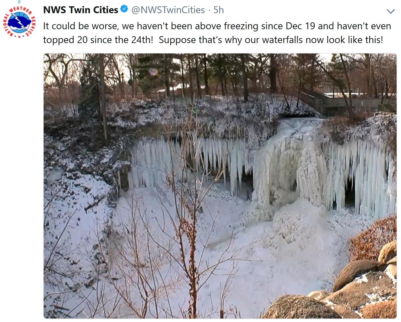
Sweet Relief. Only in Minnesota (and parts of Alaska) is an extended outlook of 30s greeted with hooting, hollering and high-fives. 20s will feel great early next week; ECMWF guidance hinting at a real thaw about 10 days out. Twin Cities meteogram: WeatherBell.

Snowfall Potential. Coastal areas are forecast to pick up anywhere from 4-12″; the heaviest amounts from near Boston into Maine, where blizzard conditions may bring (all) traffic to a standstill. New York and Philly may see 4-6″ of snow. 12km NAM guidance: NOAA and Tropicaltidbits.com.


USA Snow Cover. Map courtesy of Praedictix and AerisWeather.

Praedictix Briefing: Issued Wednesday, January 3rd, 2018:
* Snow and ice are causing treacherous conditions across parts of Florida and Georgia this morning. I-10 in northern Florida from MM 259 to MM 203 was closed due to icy conditions, according to the Florida Department of Transportation. As of 9:30 AM ET, poweroutage.us reported over 11,000 customers in northern Florida without power.
* Ice and snow will continue across the Southeast into the Mid-Atlantic today and tonight. Snow amounts could top 6” in spots across the region, with up to a half an inch of ice expected across parts of northern Florida and southern Georgia. This will continue to cause travel issues as well as power outages.
* As this system moves north, heavy snow will quickly spread into the Northeast by Thursday morning. This system will quickly strengthen, leading to strong winds with gusts topping 50 mph tomorrow in areas as well as 6-12”+ of snow from Long Island through eastern Massachusetts (including Boston) and into eastern Maine. A Blizzard Warning is in effect for Portland, ME, with a Winter Storm Warning for Boston.

Snow And Ice Across The Southeast This Morning. Snow and ice are falling across the Southeast this morning from northern Florida to eastern South Carolina, with numerous reports of ice on roads, bridges, vehicles and tree branches. Some roads across the region have been closed due to the ice.
Travel will be impacted across the Southeast today due to the snow and ice. Here are links to the local Department of Transportation offices in:
- Florida: https://fl511.com/List/Alerts
- Georgia: http://www.511ga.org/
- South Carolina: http://www.511sc.org/
- North Carolina: https://tims.ncdot.gov/tims/
- Virginia: http://www.511virginia.org/

Timing Out Precipitation. Snow and ice will continue across parts of the Southeast – from northern Florida into South Carolina – through the early afternoon hours, spreading into North Carolina and southeast Virginia this afternoon. Precipitation will taper off in South Carolina tonight, and into North Carolina tomorrow morning. By Thursday morning, however, snow will have already spread across much of the Northeast, including in Washington D.C., Philadelphia, New York City and Boston. By Thursday Night, the snow will mainly be across New England, gradually coming to an end into Friday. Across the Northeast, strong (potentially damaging) winds will accompany this heavy, wet snow. With snowfall rates up to 2” an hour in spots Thursday, the combination of the two will lead to blizzard conditions, especially near the coasts of Massachusetts and Maine.

Advisories And Warnings In The Southeast. Winter Storm Warnings and Winter Weather Advisories stretch from northern Florida along the Atlantic coast in the Southeast and Mid-Atlantic, along the path of snow and ice that is expected across the region. These are in effect for the potential of accumulating snow and ice across the region which will impact travel and have the potential to bring down power lines. These alerts are in effect through the midday hours today across the far southern extent of the warnings/advisories into Thursday the further north you go.

Snowfall Forecast Across The Southeast. Snow totals will range from less than an inch across northern Florida to over a half a foot across portions of northeastern North Carolina and eastern Virginia. A bullseye of 3-6” is also possible across interior southeast Georgia. This snow will have the potential to impact travel and cause reduced visibilities across the region, as well as cause power outages.
NWS Most Likely Snowfall Totals Across The Southeast. Based on NOAA guidance, here are the most likely snowfall totals for more select cities:
Jacksonville, FL:

Charleston, SC:

Wilmington, NC:

Newport, NC:

Wakefield, VA:


Ice Forecast Across The Southeast. Not only is snow expected along the path of the wintry precipitation across the Southeast, but accumulating ice will cause travel and power issues as well. For the most part areas on this map shaded in pink will see between 0.01” and 0.2” of an inch of ice. However, the heaviest ice is expected across parts of northern Florida and southern Georgia, where up to a half an inch could accumulate. Any amount of ice will add to slick road conditions across the region, making travel tough, but especially areas that see over a tenth of an inch of ice could see downed branches/trees/power lines and power outages.

Ice Across Northern Florida And Southern Georgia. Across northern Florida and southern Georgia is where the heaviest ice accumulation is expected, with some areas potentially receiving up to a half an inch of ice by tonight.

Blizzard Warnings For Parts Of The Northeast. The wintry precipitation associated with this system will move into parts of the Northeast tonight through Friday, with snow expected. This system will quickly intensify, leading to heavy snow and very gusty winds across the region. Winter Storm and Blizzard Warnings are in effect from coastal New Jersey and across parts of Long Island northward into Maine. Blizzard Warnings mean that blizzard conditions (visibilities of ¼ miles or less and winds in excess of 35 mph for at least three hours) are expected. Across the Northeast major metro areas:
- New York City is under a Winter Storm Watch from 1 AM tonight through midnight Thursday Night.
- Boston is under a Winter Storm Warning from 1 AM tonight through 1 AM Thursday Night. Blizzard Warnings are in effect for coastal Essex and portions of southeastern Massachusetts as well as Block Island in Rhode Island.
- Portland, ME is under a Blizzard Warning from noon Thursday through 1 AM Thursday Night.
- As of early Wednesday morning, Philadelphia and Washington D.C. weren’t under any advisories.

Snowfall Forecast Across The Northeast. The heaviest snow across the Northeast is expected to fall from Long Island to eastern Maine, where at least a half of foot of snow is forecast to fall. From eastern Massachusetts to eastern Maine, snow totals could easily top a foot through the end of the week, including in the Boston area. Even though this will be a quick moving system, snowfall rates of up to 2” per hour are expected, allowing the snow to quickly accumulate across eastern New England. The heaviest snow across the Boston area is expected between 10 am to 4 pm Thursday.
NWS Most Likely Snowfall Totals Across The Northeast. Based on NOAA guidance, here are the most likely snowfall totals for more select cities:
Philadelphia, PA:

New York, NY:

Boston, MA:

Portland, ME:

Caribou, ME:


Strong Wind Gusts Expected Thursday. Strong winds will accompany the snow Thursday across the Northeast, with gusts over 50 mph in Boston at times during the day. These strong winds, in combination with the snow, will lead to blizzard conditions across the region. These strong winds will also lead to the potential of increased power outages across the region. This could end up being an issue heading into Thursday Night as very cold air will spread into the Northeast behind this system. These winds could also knock down branches and trees.

Blizzard Potential. AerisWeather’s Blizzard Potential Index shows a high likelihood of blizzard conditions with the wintry precipitation across parts of eastern North Carolina and Virginia tonight, spreading across the Northeast throughout the day Thursday. This is indicative of low visibility, which will help create difficult travel across the region.
Summary: Snow and ice are falling across parts of the Southeast this morning, and have already caused road closures and power outages in the region. This wintry precipitation will continue throughout the day before moving north into the Mid-Atlantic by the evening. Overall snow totals across the Southeast will range from under an inch to a half a foot in spots, with ice accumulations up to a half an inch possible across parts of northern Florida and southern Georgia. This strengthening storm then moves into the Northeast by Thursday morning, bringing the potential of heavy snow – especially from Long Island through eastern Massachusetts and eastern Maine – as well as potentially damaging winds. This will lead to blizzard conditions and the potential of power outages. Boston could see a foot of snow by the time this snowstorm moves out Thursday Night.
D.J. Kayser, Meteorologist, Praedictix
Much of Puerto Rico Still in the Dark. Here are a couple of excerpts from a Quartz update: “Hurricane Maria made landfall on Puerto Rico more than three months ago. And the latest figures show 45% of electricity customers in Puerto Rico still don’t have power….On Dec.29, the governor put the official estimate of those in the dark at more than 660,000 people, 45% of the island’s 1.5 million electricity customers. So now, 104 days since Maria hit, the 660,000 figure is the first to come directly from the Puerto Rican government. A group of local engineers estimated on Dec. 11 that roughly half of the island’s total 3.4-million population still had no power, according to the Associated Press…”

Only Once Has America Seen More Billion-Dollar Disasters. Bloomberg Quint has the article: “…Among the most devastating events were hurricanes Harvey, Irma and Maria and wildfires in northern California. The killer storms caused economic losses of more than $210 billion in the U.S. and across the Caribbean, and about $100 billion in insured damages, according to Mark Bove, a senior research scientist with Munich Reinsurance America in Princeton, New Jersey. The list goes on — ruinous hail in Colorado and Minnesota, tornado outbreaks across the Midwest and South, flooding that damaged a massive dam in California and triggered evacuations downstream. A lake-effect snowband off Lake Erie dumped 34 inches of snow at Pennsylvania’s Erie International Airport on Christmas Day, quadrupling the previous record from 2002, according to the Weather Channel. A warming climate can bring an increase in lake-effect snow, according to NOAA…”

Weather Satellite and Scientists May Face Funding Drought Despite Devastating Hurricanes. An Op-Ed at TheHill caught my eye – here’s a clip: “…The recurrence of extreme weather is nearly assured. Funding for the JPSS program is not. The JPSS program will continue until 2038 — if Congress continues to fund it. The success of a satellite program does not hinge solely on successful launches to replace older satellites, however. Congress must also fund the applied scientific research necessary to use the new data and improve weather forecasts in the decades to come. JPSS will assist meteorologists in monitoring the evolving state of the atmosphere and oceans, bettering predictions of severe weather events. This is information we need to know. In 2017, the United States had 15 weather disasters with losses exceeding $1 billion each, for a cumulative cost of over $25 billion, according to government estimates...”
File image: NOAA NESDIS.

In All Likelihood, Someday the Sun Will Knock Out the Grid. A story at Popular Science increased my desire to get off the grid: “…Today, modern society relies on exactly the devices that such a storm disrupts. A 2017 study in the American Geophysical Union’s Space Weather journal estimated the effect if a solar storm as great as the largest on record—an 1859 shakeup called the Carrington Event—were to strike again. It would cost the United States $42 billion per day. The repercussions could last years, perhaps decades. The power grid could fail. You wouldn’t be able to get money out of a bank. Businesses couldn’t operate. Water pumps wouldn’t work; phones either. Food would go bad. Governments would have a hard time governing. “We have created an incredible vulnerability, unlike any other,” says Bill Murtagh, program coordinator for the Space Weather Prediction Center, the celestial arm of the National Oceanic and Atmospheric Administration, headquartered in Boulder, Colorado…”
File image: NASA.

Tax Overhaul Leaves Minnesota Clean Energy Future Uncertain. The markets hate regulatory uncertainty. Here’s an excerpt from Associated Press: “…Gregg Mast is the executive director of Clean Energy Economy Minnesota, a nonprofit that represents clean energy businesses. Mast said the uncertainty the new tax law creates is not good for business. He said he’s working with a congressional delegation and business leaders to better understand the impact of the measure on the renewable energy industry and energy efficiency. “It’s early,” Mast said. “I think with a tax bill this large, there’s always an opportunity to come back with a fix bill to address some of those provisions that, perhaps, were not thought of early on.” Wind and solar energy has grown in Minnesota because of the tax credits, and that growth is expected to continue through 2018 because utilities have been planning such expansions for years. But smaller companies might find themselves in a less comfortable position, according to Beth Soholt, executive director of Wind on the Wires...”
Big Money is Backing Out of Fossil Fuel Industry, Moving Into Greener Alternatives. Here’s an excerpt from PRI, Public Radio International: “…That same day, Scott Stringer, the comptroller of New York City, announced a similar fossil fuel free strategy for the city’s pension fund, which is comparable in the number of assets. “Those are two of the 20 largest funds on the planet,” McKibben says. “So, the same day that in Washington they were passing the tax bill that gave ludicrous tax breaks to the fossil fuel industry in the world’s center of finance, New York, they were saying, ‘No, we don’t think this is good business anymore.’ “If the center of the world’s financial markets is sending the signal that we don’t want to do this anymore, it’s going to get harder and harder for the Exxons and Chevrons of the world to keep out there finding more fossil fuels that we don’t need and can’t burn…”

2017 Was Safest Year on Record for Airline Passengers. There was some good news last year. Here are a couple of clips from The Independent: “In a year when more people flew to more places than ever, 2017 was the safest on record for airline passengers. The Dutch-based aviation consultancy, To70, has released its Civil Aviation Safety Review for 2017. It reports only two fatal accidents, both involving small turbo-prop aircraft, with a total of 13 lives lost. No jets crashed in passenger service anywhere in the world…The report warns that electronic devices in checked-in bags pose a growing potential danger: “The increasing use of lithium-ion batteries in electronics creates a fire risk on board aeroplanes as such batteries are difficult to extinguish if they catch fire. “Airlines worldwide are training their crews to fight any fires in the cabin; the challenge is keeping such batteries out of passenger luggage.” In 2016, 271 people lost their lives in seven fatal events…”

Robots Are Going to Turbocharge One of Society’s Biggest Problems. Quartz explains: “…On the flip side, it warned that automation will widen the pay gaps for women and minorities since robots are likely to phase out lower-skilled jobs over the next few decades, and the jobs created in their place will be more highly skilled. Low-wage jobs are five times more likely to be automated than higher paid jobs, according to the report. “Automation risks increasing gender and race inequality,” says IPPR, noting that women and some minority groups are more likely to work in low-skill, “automatable” occupations. “The impact on inequality will depend on the skill-level of new jobs created and individuals’ ability to access opportunities…”

Best Cities for Beer Lover? Duluth ranks third in the USA, details from SmartAsset: “Sometimes when it comes to beer quantity is more important than quality. For beer drinkers who follow that philosophy Duluth is probably a good place to stumble into. Duluth has 31 bars per 100,000 residents and 10.4 breweries per 100,000 residents. That means plenty of options for where to get a brew. Best of all, a night out on the town won’t run your savings account dry in Duluth. Our data shows the average pint of draft beer in Duluth costs only $2…”

Parking for Gold. Valet as a competitive sport? Check out a story at The Atlantic: “…At first glance, an Olympics organized entirely around valet parking seems absurd: a luxury service treated as a Decathlon. Yet the Valet Olympics draw attention to a line of work—or, as some would say, an emerging motorsport—that few ever pause to consider. Successful valets boast automotive skills unappreciated outside the parking lot. And valet parking is a hidden vein of economic opportunity that provides full-time work, first jobs, and summer employment to thousands. For immigrants from Nigeria, India, or Ecuador, or displaced by war in Iraq, the industry can supply a much-needed foothold in the United States, even launching a lifelong career. What’s more, as cities grow in size and complexity, America’s urban centers are becoming harder to navigate—with byzantine parking laws, dense downtowns that require real-life Tetris skills to park, and massive lots located blocks from the venues they serve. All of this makes valets, as they invisibly rearrange streets, the set designers of every busy cityscape…”
Image credit: Alex Dos Diaz.
In Search of the Perfect Nap. 20-30 minutes seems about right. A story at PopSugar reminded me that I need a nap: “…A CDC study found that more than 40 million workers get fewer than six hours a night, in spite of a National Sleep Foundation report that indicates that we all need between seven and nine hours a night. Needless to say, coming up that light on your sleep needs makes naps a necessity to just catch up on rest and be able to get through all the tasks we have on our schedules on a daily basis. If you reach for sugar in the afternoon to stave off the Zs, then you’re also a person who could use a nap — and better nutrition!...”

11 F. maximum temperature yesterday in the Twin Cities.
24 F. average high on January 3.
32 F. high on January 3, 2017.
January 4, 1981: Air cold enough to freeze a mercury thermometer pours into Minnesota. Tower hits 45 below zero.
January 4, 1971: A snowstorm moves through the Upper Midwest. Winona gets over 14 inches.

THURSDAY: Sunny, comfortably numb. WC: -15. Winds: NW 3-8. High: 4
THURSDAY NIGHT: Mostly clear. Low: -10
FRIDAY: Plenty of sunshine, chilly. Winds: NE 3-8. High: 5
SATURDAY: Clouds increase, not as brutal. Winds: S 10-15. Wake-up: -9. High: 13
SUNDAY: Few flurries, nice to be average again. Winds: NW 8-13. Wake-up: 9. High: 26
MONDAY: Mostly cloudy, feels better out there. Winds: SW 5-10. Wake-up: 20. High: near 30
TUESDAY: Some sun, turning colder. Winds: NW 10-20. Wake-up: 19. High: 22
WEDNESDAY: Sunny start, light snow late? Winds: SE 5-10. Wake-up: -5. High: 11
Climate Stories…

Scientists Can Now Blame Individual Natural Disasters on Climate Change. Here’s an excerpt of an article at Scientific American: “...Nearly 15 years later, extreme event attribution not only is possible, but is one of the most rapidly expanding subfields of climate science. “The public stance of the scientific community about individual event attribution in the year 2000 is that it’s not something that science does,” said Noah Diffenbaugh, a Stanford University climate scientist and attribution expert. “And so to go from that to now, that you’ll find a paper every week … that’s why we say there’s been an explosion of research. It’s gone from zero to 60, basically.” Over the last few years, dozens of studies have investigated the influence of climate change on events ranging from the Russian heat wave of 2010 to the California drought, evaluating the extent to which global warming has made them more severe or more likely to occur. The Bulletin of the American Meteorological Society now issues a special report each year assessing the impact of climate change on the previous year’s extreme events. Interest in the field has grown so much that the National Academy of Sciences released an in-depth report last year evaluating the current state of the science and providing recommendations for its improvement…”

2017 Crushed a Major Temperature Record and Scientists Are Sounding the Alarm. Here’s a clip from a story at ThinkProgress: “…Environmental scientist Dana Nuccitelli explained in the UK Guardian Tuesday, “For each type of year — La Niña, El Niño, and neutral — the global surface warming trend between 1964 and 2017 is 0.17–0.18°C per decade, which is consistent with climate model predictions.” What’s so remarkable about 2017, Nuccitelli notes, is that it crushed the old record for hottest non-El Niño year (2014) by “a whopping 0.17°C.” In fact, 2017 was so hot, it’s the second hottest year on record, surpassing even 2015, which had a strong El Niño. “The fact we continue to see records break regardless of the natural conditions means that we humans have over-ridden the natural cycle,” Abraham points out...”
Graphic credit: “1964–2017 global surface temperature data from NASA, divided into El Niño (red), La Niña (blue), and neutral (black) years, with linear trends added.” CREDIT: Dana Nuccitelli.

How Ocean “Hot Spots” May Magnify Sea Level Rise and Coastal Flooding. Newsweek has a summary of new research; here are 2 excerpts: “…In a study we co-authored with our colleague Jon Martin, we showed that two converging natural climate processes created a “hot spot” from Cape Hatteras, North Carolina to Miami where sea levels rose six times faster than the global average between 2011 and 2015. We also showed that such hot spots have occurred at other points along the Eastern Seaboard over the past century. Now we see indications that one is developing in Texas and Louisiana, where it likely amplified flooding during Harvey—and could make future coastal storms more damaging…In summary, we found that short-term accelerations in sea level rise have repeatedly occurred over the last century, sometimes occurring south of Cape Hatteras and sometimes focused north of the Cape. These hot spots can exceed rates of four inches in five years, and can occur anywhere along the U.S. Atlantic coast. They form when the accumulated signals of ENSO and the NAO converge, displacing seawater toward the coastline...”

Ice Loss and the Polar Vortex: How a Warming Arctic Fuels Cold Snaps. InsideClimate News connects the dots: “…New research shows that some northern regions have been getting hit with these extreme cold spells more frequently over the past four decades, even as the planet as a whole has warmed. While it may seem counterintuitive, the scientists believe these bitter cold snaps are connected to the warming of the Arctic and the effects that that warming is having on the winds of the stratospheric polar vortex, high above the Earth’s surface. Here’s what scientists involved in the research think is happening: The evidence is clear that the Arctic has been warming faster than the rest of the planet. That warming is reducing the amount of Arctic sea ice, allowing more heat to escape from the ocean. The scientists think that the ocean energy that is being released is causing a weakening of the polar vortex winds over the Arctic, which normally keep cold air centered over the polar region. That weakening is then allowing cold polar air to slip southward more often...”
Map credit: “A strong polar vortex (left, from December 2013) is centered over the Arctic. A weakened polar vortex (right, from January 2014) allows cold air to dip farther south.” Credit: NOAA.

Science Says: Why There’s a Big Chill in a Warming World. Seth Borenstein explains for The Associated Press: “…This is an area of hot debate and research among scientists and probably is a mix of human-caused climate change and natural variability, said Furtado. Climate change hasn’t made the polar vortex more extreme, but it probably is making it move more, which makes the weather seem more extreme, he said. A recent study by Potsdam Institute climate scientist Marlene Kretschmer found the polar vortex has weakened and meandered more often since 1990, but that study focused more on Europe. Ongoing research shows that there seems to be a similar connection for more frequent Arctic cold snaps like what the U.S. is now experiencing, Kretschmer said. Don’t confuse weather — which is a few days or weeks in one region — with climate, which is over years and decades and global. Weather is like a person’s mood, which changes frequently, while climate is like someone’s personality, which is more long-term, Furtado said…”
Photo credit: “Chris McGuire tries to stay warm as he waits for a space at the City Rescue Mission on Tuesday, Jan. 2, 2018, in Jacksonville, Fla. Dangerously cold temperatures blamed for several deaths have wreaked havoc across a wide swath of the U.S., freezing a water tower in Iowa, halting ferry service in New York and leading officials to open warming centers even in the Deep South.” (Will Dickey/The Florida Times-Union via AP).

It’s Cold Outside, But That Doesn’t Mean That Climate Change Isn’t Real. USA TODAY explains the difference between “weather” and “climate”: “…But there’s a big difference between weather and climate, scientists say: Weather happens in the short term, while global climate systems influence weather over longer time scales. Daily or weekly weather patterns “say nothing about longer term climate change,” said J. Marshall Shepherd, director of the atmospheric sciences program at the University of Georgia and a former president of the American Meteorological Society. “The clothes that you have on today do not describe what you have in your closet but rather how you dressed for today’s weather. The range of clothing that you have in your closet is climate,” Shepherd said in an email...”

Hurricanes and Heat Waves: Stark Signs of Climate Change “New Normal”. Here’s a clip from a story at The Guardian: “…Eight states – Arizona, New Mexico, Florida, Georgia, North Carolina, South Carolina, Virginia and West Virginia – have in fact experienced record warmth for the first 11 months of the year. A national record, however, is out of reach due to the lack of an El Niño, a periodic climatic event that appeared last year and spurred extra heat. But the fingerprint of climate change extends beyond just temperature. California’s deepest drought on record was broken by intense rainfall at the start of the year, an example of the long dry spells interrupted by ferocious downpours that scientists say are becoming more frequent in a warming world. To the north, Arctic sea ice reached a record low wintertime maximum extent as, incredibly, temperature instruments in Alaska malfunctioned due to the surging warmth…”


Three 2016 Weather Extremes “Not Possible” Without Human Warming. Yale Climate Connections reports: “For the first time, an annual report issued by the American Meteorological Society has found that the extreme magnitudes of three weather events in 2016 “was not possible without the influence of human-caused climate change. ” Explaining Extreme Events of 2016 from a Climate Perspective, published as a supplement to the Bulletin of the American Meteorological Society (BAMS), is AMS’s sixth annual report on extreme weather events. It was officially released and presented on December 13 at the American Geophysical Union’s fall meeting in New Orleans. The report includes 27 peer-reviewed scientific papers. Authors of those papers examined 21 different extreme weather events around the globe in 2016 – including wildfires in North America and Australia, droughts in South Africa and Brazil, cold snaps in Eastern China, and an anomalous body of warm water in the Pacific Ocean...”
