.gif)
Snowfall Potential Through Sunday
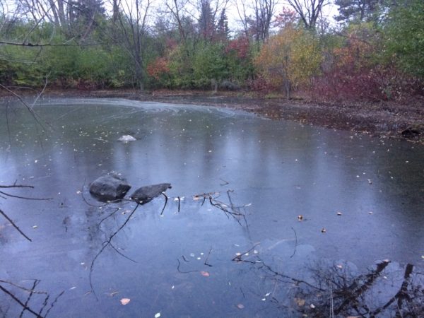
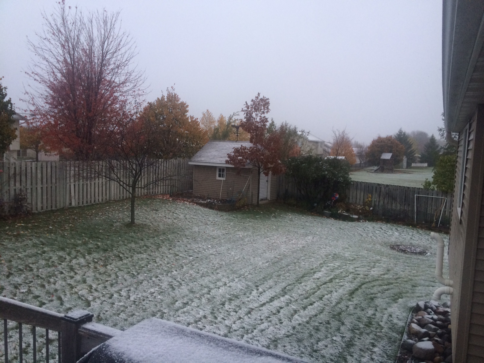
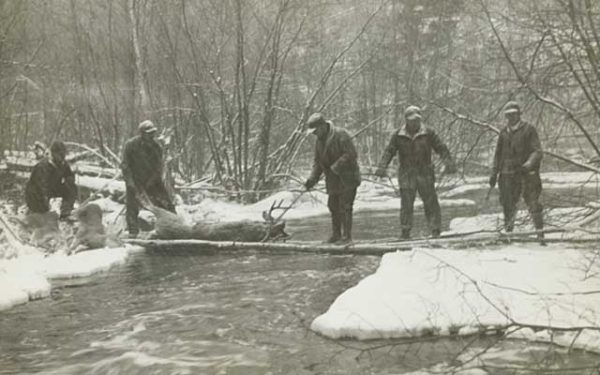
Here’s the snowfall potential through Sunday, which suggests some 3″ to 6″+ tallies possible across the northern half of the state. While some may not like the snowy forecast, Deer Hunters heading into the Minnesota woods will be happy that there will be a little tracking snow this year. It will be a MUCH different story this year compared to last when it was unusually warm!

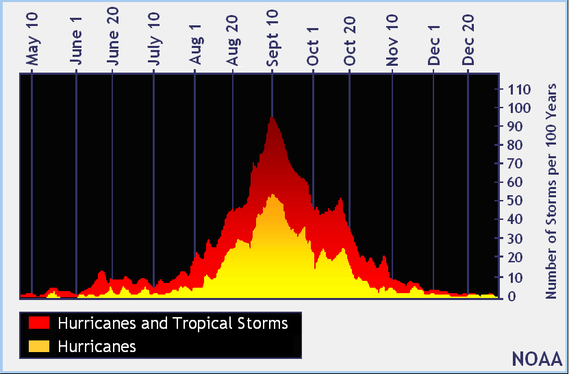
September 10th – Official Peak of the Atlantic Hurricane Season
We are less than 1 month from the official close of the Atlantic Hurricane Season (November 30th). Note that peak activity generally occurs on September 10th and stays somewhat active through the month of October, but really diminishes through the month of November. With that said, there have been years where tropical activity continues through the end of the year and even into the follow calendar year! 2005 was one of those years as Tropical Storm Zeta developed December 30th and continued through January 6th, 2006.
___________________________________________________________
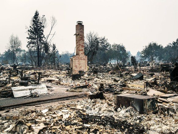
“AFTER THE NAPA FIRES, A DISASTER-IN-WAITING: TOXIC ASH”
“BY ANY MEASURE, the fires that tore through Northern California were a major disaster. Forty-two people are dead, and 100,000 are displaced. More than 8,400 homes and other buildings were destroyed, more than 160,000 acres burned—and the fires aren’t all out yet. That devastation leaves behind another potential disaster: ash. No one knows how much. It’ll be full of heavy metals and toxins—no one knows exactly how much, and it depends on what burned and at what temperature. The ash will infiltrate soils, but no one’s really sure how or whether that’ll be a problem. And eventually some of it—maybe a lot—will flow into the regional aquatic ecosystem and ultimately the San Francisco Bay. That’s the bomb. Here’s the timer: An old, grim joke about California says that the state has only three seasons: summer, fire, and mudslides. Those mudslides happen because of rain; the Santa Ana (or Diablo, if you’d prefer) wind-driven wildfires of autumn give way to a monsoon season that lasts through winter and into spring. The rains of 2016–2017 ended a longstanding drought and broke all kinds of records.”
_____________________________________________________________________
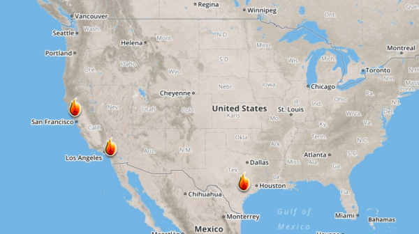
Ongoing Large Wildfires
Here’s a look at the current wildfire map across the country. Note that wildfire activity as REALLY slowed down with only a few major wildfires still burning across parts of California and in Texas.
Here’s a list of all the current large wildfires from Inciweb:
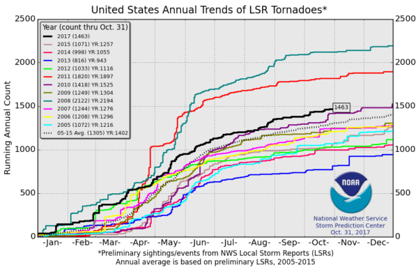
It certainly has been a fairly active first half of 2017 with 1,463 preliminary tornado reports through October 31st. Note that this is the most tornadoes through that date since 2011, when there were 1,820 reports. The map below shows the distribution of the tornadoes so far this year.
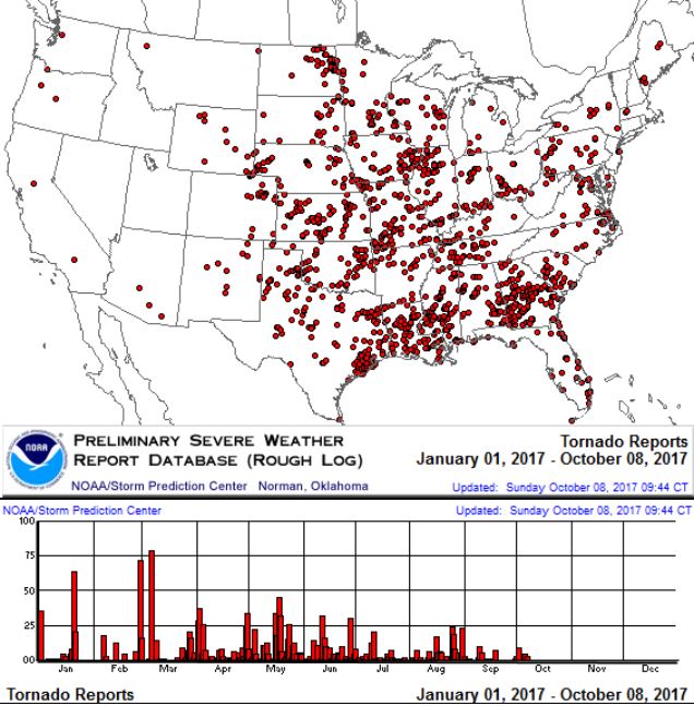
PRELIMINARY 2017 Tornado Count
According to NOAA’s SPC, the PRELIMINARY 2017 tornado count is 1,463 (through October 31st). Note that is the most active year for tornadoes since 2011, when there were 1,820 tornadoes. Keep in mind there was a major tornado outbreak in the Gulf Coast region from April 25-28, 2011 that spawned nearly 500 tornadoes, some of which were deadly. That outbreak is known as the Super Outbreak of 2011 and has gone down in history as one of the biggest, costliest and one of the deadliest tornado outbreaks in history.
_____________________________________________________________________
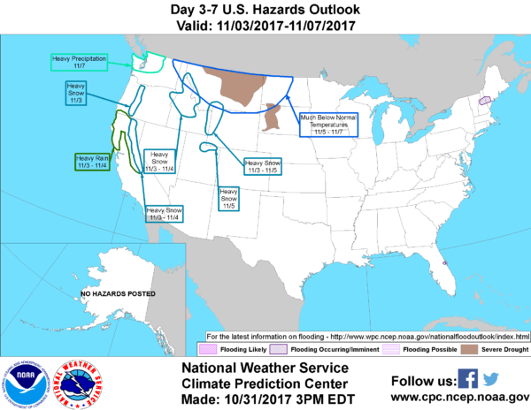
National Weather Hazards Ahead…
1.) Heavy snow across portions of the Cascades of Oregon, Fri, Nov 3.
2.) Heavy snow across portions of the Sierra Nevadas, Fri-Sat, Nov 3-4.
3.) Heavy rain across portions of California and Oregon, Fri-Sat, Nov 3-4.
4.) Heavy snow across portions of the Great Basin and Northern Rockies, Fri-Sat, Nov 3-4.
5.) Heavy snow across portions of the Northern and Central Rockies, Fri-Sun, Nov 3-5.
6.) Heavy snow across portions of the Uinta Mountains, Sun, Nov 5.
7.) Much below-normal temperatures across portions of the Northern Plains, the Northern Rockies, and the Northern Great Basin, Sun-Tue, Nov 5-7.
8.) Heavy precipitation across portions of Washington state, Tue, Nov 7.
9.) Flooding occurring or imminent across portions of Florida and the Northeast.
10.) Moderate risk of much below-normal temperatures for portions of Washington state through North Dakota, Wed-Fri, Nov 8-10.
11.) Moderate risk of much below-normal temperatures for portions of northern California, Wed, Nov 8.
12.) Slight risk of much below normal temperatures for portions of Great Basin, the Northern Plains, the Northern and Central Rockies, California, and the Pacific Northwest, Wed-Sun, Nov 8-12.
13.) Severe Drought across the Northern Plains, the Northern Rockies, and Hawaii.
_________________________________________________________
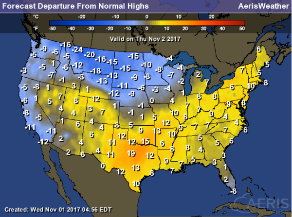
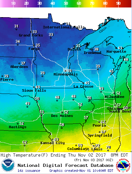
Here’s a look at high temperatures across the nation on Tuesday, which suggests that temperatures across parts of the Western US, High Plains and Midwest will be below average. Note that some locations in Montana could be nearly 25F below average. On the other hand, folks from the Northeast to the Southern US will once again be above average. In fact, some in Texas could be nearly 20F above average, where the mercury could hit 90F!
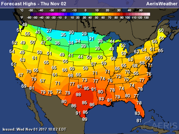
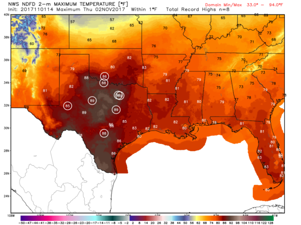
Record Warmth in Texas on Thursday
It’ll be so warm on Thursday that a number of record highs will likely fall across parts of Texas and into Oklahoma. Interestingly, Dallas/Ft. Worth has never hit 90F during the month of November (only month to have never have a 90F high) and could possibly do that on Thursday.
National Weather Outlook
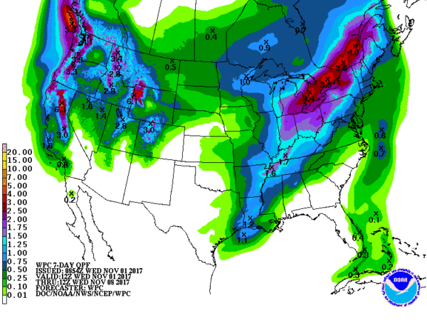
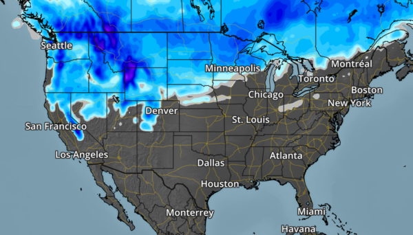
Here’s the weather outlook through the end of the week, which shows fairly active weather across the country with one storm moving into the Eastern half of the country, while another system moves into the Western half of the country. Areas of heavy rain and thunderstorms will be found across the lower half of the Mississippi Valley, while areas of heavy snow will be found across the northern half of the Rockies. Also note that widespread rainfall will begin moving in along much of the West Coast as we head into the end of the week and weekend ahead!
.gif)
According to NOAA’s WPC, areas of heavy precipitation will be possible across the lower half of the Mississippi Valley and into the Ohio Valley/Great Lakes and parts of the Northeast. Another area of heavy precipitation will also be found across the Western US, especially in the high elevations, where several inches of precipitation will likely fall through the early part of next week. Note that much of that precipitation will fall in the form of heavy mountain snow!
By Paul Douglas
This Day in Weather History
November 2nd
1938: A tornado touches down at Nashwauk in Isanti County. Many livestock killed.
1842: A mild spell occurs at Ft. Snelling, where the temperature rises to 60 degrees.
________________________________________________________
Average High/Low for Minneapolis
November 2nd
Average High: 49F (Record: 72F set in 1978)
Average Low: 33F (Record: 9F set in 1951)
Record Rainfall: 0.72″ set in 1901
Record Snowfall: 5.3″ set in 1992
_________________________________________________________
Sunrise/Sunset Times for Minneapolis
November 2nd
Sunrise: 7:53am
Sunset: 5:59pm
Hours of Daylight: ~10 hours 6 mins
Daylight LOST since yesterday: ~2 minutes and 45 seconds
Daylight LOST since summer solstice (June 20th): 5 hours & 31 minutes
__________________________________________________________
Moon Phase for November 2nd at Midnight
0.9 Days Until Full “Beaver” Moon
“Nov. 4, 1:23 a.m. EST – Full Beaver Moon. This was the time of year when the old Native American tribes set beaver traps, to ensure a supply of warm winter furs before the swamps froze. Another interpretation suggests that the name Beaver Full Moon comes from the fact that the beavers are now active in their preparation for winter. It’s also called the Frosty Moon.”

_________________________
Thursday will be another chilly day across the region with temps running nearly 10F to 15F below average with highs only warming into the 30s across Minnesota and the northern half of Wisconsin.
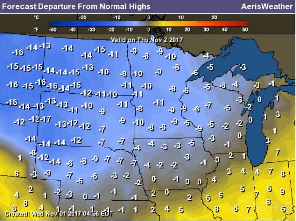
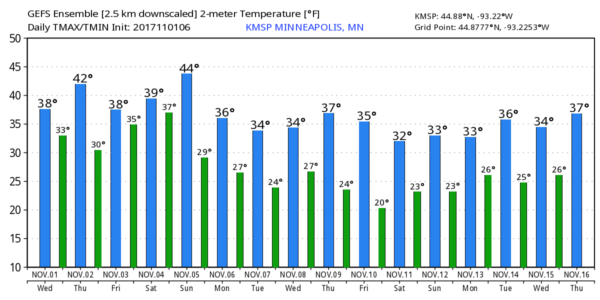
Here’s the temperature outlook through November 16th, which shows chilly temps continuing as we head through the first half of the November. For the most part, highs will only warm into the 30s, but there could be a couple/few days that see readings in the 40s.
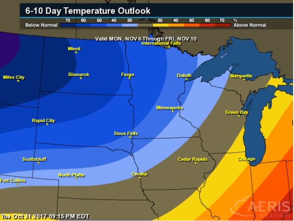
6 to 10 Day Temperature Outlook
According to NOAA CPC, there is a good chance that below average temps will continue across parts of the Midwest into the 2nd week of November.
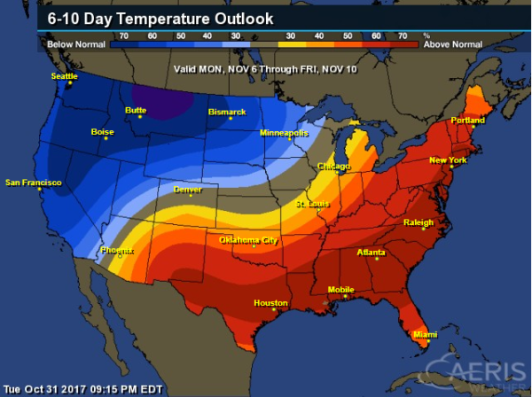
6 to 10 Day Temperature Outlook
According to NOAA’s CPC – much of the nation will remain above average with the exception of the Western US and Midwest, where cooler than average temps will be found.
_____________________________________________________________________
__________________________________________________________________________

________________________________________________________________________

________________________________________________________________________

____________________________________________________________________________