by Paul Douglas | Jun 12, 2017 | Blog
1.82″ rain fell yesterday in the Twin Cities. 69 mph peak wind gust from yesterday’s severe storms (MSP International Airport). 79 F. maximum temperature in the Twin Cities yesterday, shortly after midnight. 78 F. average high on June 11. 93 F. high on...
by Paul Douglas | Jun 11, 2017 | Blog
96 F. maximum temperature in the Twin Cities Saturday. 77 F. average high on June 10. 91 F. high on June 10, 2016. June 11, 2011: Severe thunderstorms bring extremely strong wind to central Minnesota. An unofficial wind gust of 119 mph is reported at a seed farm 1...

by Paul Douglas | Jun 10, 2017 | Blog
86 F. Twin Cities maximum temperature yesterday. 77 F. average high on June 9. 84 F. high on June 9, 2016. June 10, 1926: An intense downpour falls on Mahoning. 3.05 inches fell in 45 minutes. If Anyone Asks: “Yes, It’s Hot Enough For Me” At...

by Paul Douglas | Jun 9, 2017 | Blog
85 F. high temperature in the Twin Cities Thursday. 77 F. average high on June 8. 79 F. maximum temperature on June 8, 2016. June 9, 2002: Extensive flash flood begins across northwest Minnesota. 14.55 inches would fall over the next 48 hours near Lake of the Woods....
by Paul Douglas | Jun 5, 2017 | Blog
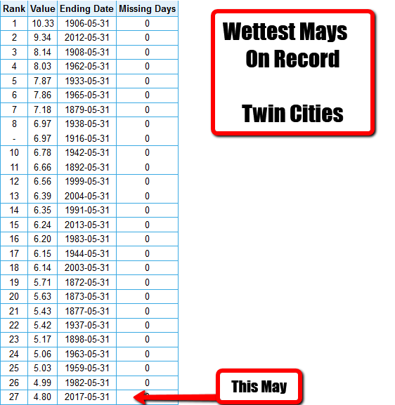
A Very Wet May In The Twin Cities It was a wet May across the Twin Cities. Overall, we saw fourteen total days with measurable (0.01″+) precipitation, which tied for the fifth most days in May with measurable precipitation on record. The most was just a few...
by Paul Douglas | Jun 4, 2017 | Blog
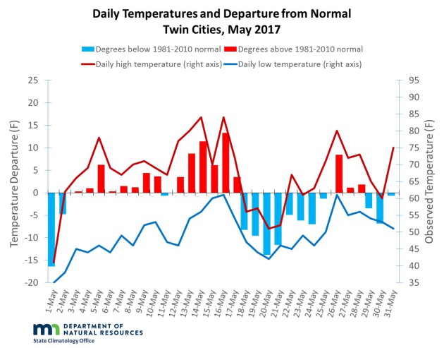
The Warm Streak Ends Did you find last month a bit cooler than average? Well, in fact it was. Thanks to a cool start to the month, and relatively cool end to the month as well, May 2017 ended the longest streak of consecutive months with an above average temperature...
