The Weather Blog
Daily weather updates
Severe Sunday? A Real Storm Next Week – Drought Upgraded to Severe
68 F. high temperature in the Twin Cities Thursday.
65 F. average high on April 30.
46 F. high on April 30, 2014.
2.3 F. April was 2.3 F warmer than average in the Twin Cities.
April 30, 2004: After a high temperature of 91 the day before in the Twin Cities, the mercury tumbled to 47 degrees by morning. St. Cloud shed 50 degrees over 12 hours.
April 30, 1967: Tornado hits southern Minnesota. Some of the towns affected were Albert Lea, Waseca, Wells, and Owatonna. Source: Twin Cities National Weather Service.
Mayday!
“Paul, are we going to have good weather?” Who’s asking? It’s been a lovely spring for cyclists and runners but a lousy spring for farmers, rightfully paranoid about drought. We’re looking at a 6- month boating season this year, but water levels are down, statewide.
4 of the last 5 springs have been “historically wet”. June 2014 was the wettest month, statewide, on record. Will history repeat itself again in 2015? With a moderate to strong El Nino taking shape in the Pacific this year may be different.
Most of Minnesota requires 3-6 inches of rain to pull out of the drought, which is now severe over central and northwest Minnesota. So if friends or loved ones whine about rain anytime soon please set them straight.
Today’s showers only settle the dust; heavier T-storms rumble in late Sunday. A few may even turn severe with hail and damaging winds.
A serious dent in the drought is possible next week. A slow-moving storm pushing across the Plains drops 1-2 inches of badly needed rain between Tuesday & Thursday.
It’s been a magical week but the weather is almost too nice: too sunny, too dry. If it rains a few inches next week farmers will be doing cartwheels in their fields!
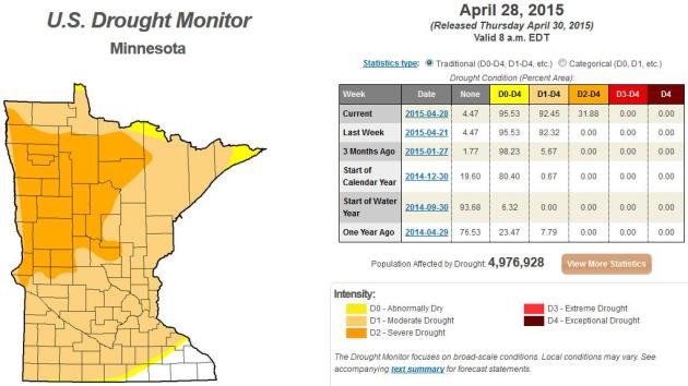
Deepening Drought. The latest U.S. Drought Monitor shows 92% of Minnesota in moderate drought, up from just 5% only 3 months ago. Almost a third of the state is now in severe drought, including Alexandria, Detroit Lakes, Wadena, Bemidji and most of the Red River Valley.
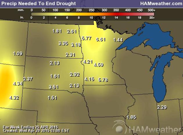
Rainfall Needed To End Drought. Here’s a product, from NOAA, USDA and AerisWeather, that shows how many inches of moisture is required to ease the drought – generally 1-3″ far eastern Minnesota, but closer to 5-7″ from central Minnesota into the Red River Valley.
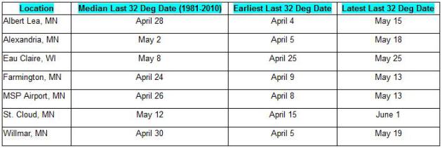
Last Freeze? I suspect most of central and southern Minnesota has experienced the last hard freeze of the winter season, although another frost or two may still materialize up north. The old adage is to wait on annuals until Mother’s Day. Good advice. More details from weather.gov.
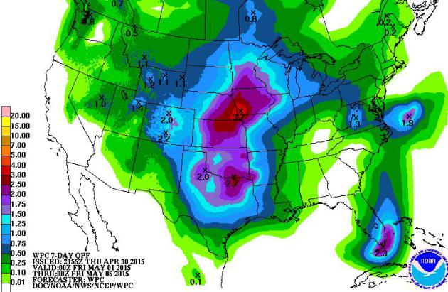
Trending Wetter. Every QPF summary from NOAA gets wetter; now an ensemble of models are hinting at 1-2″ of rain by Thursday of next week; most of that coming the middle of next week. Some 3-4″ amounts are possible near Omaha.
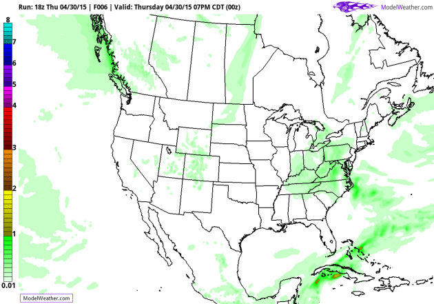
A Slug of Southern Moisture. NOAA’s .25 GFS model shows strong T-storms pushing across Minnesota Sunday; a slow-moving storm tracking across the Plains will pull moisture from the Gulf of Mexico next week, sparking significant showers and T-storms – maybe a couple inches of rain.
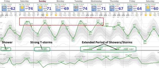
April Showers Bring…May Showers. As the jet stream lifts north storms that detoured south of Minnesota stand a better chance of brushing us with significant rain in the coming couple of weeks. A passing shower today gives way to some lukewarm sun Saturday; strong T-storms Sunday afternoon and evening. A dry Monday gives rise to periods of showers and heavy T-storms Tuesday thru Thursday of next week. Let it rain. Source: Weatherspark.
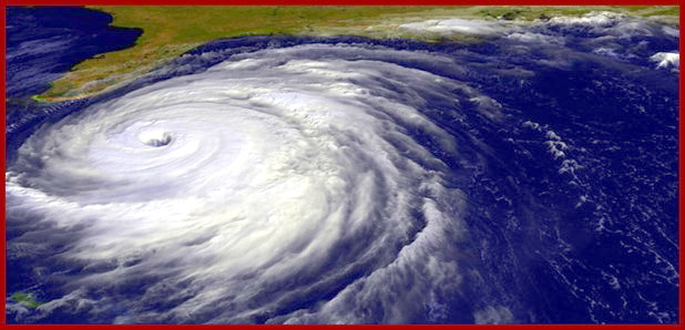
What’s Driving Our Major Hurricane Landfall Drought? Study Says Its Just Dumb Luck. Officials are very concerned about a sense of apathy, especially in Florida. As it goes with luck at some point it runs out. Here’s an excerpt from The Capital Weather Gang: “…The researchers used a statistical hurricane model to simulate the years 1950 to 2012 a thousand times to understand the range of possibilities in the North Atlantic ocean basin. Using the statistical hurricane landfalls from the model, they were able to conclude that the average wait time for a major hurricane drought is 177 years. So why are we in this 177-year drought situation at the moment? It really does appear to be luck — or coincidence, if you prefer...”
Why Tornadoes Find and Flatten Trailer Parks. No, mobile homes don’t “attract” tornadoes in some strange and supernatural way, but in most metro areas the regions where trailer parks are most likely to be located is also at heightened risk of tornadoes, as explained by azcentral.com; here’s an excerpt that made me do a double-take: “…This gets complicated, meaning I didn’t understand it very well, but the study showed some statistical evidence tornadoes cause the most damage in “transition zones.” Those are areas of the Earth’s surface where two distinct types of landscapes meet. That would include areas such as the fringes where urban sprawl and farmland or forests and plains meet. And those fringe areas tend to be where trailer parks are most frequently located…”
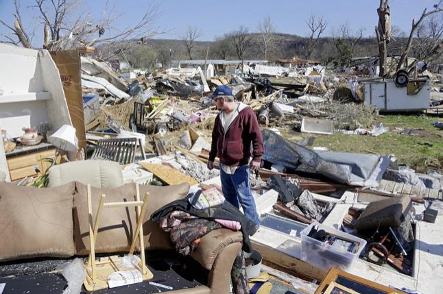
Photo credit above: “Mike Cook surveys the damage in what is left of his home at River Oaks mobile home community in Sand Springs, Okla., Thursday, March 26, 2015, after a tornado on Wednesday. Oklahomans salvaged soggy belongings Thursday after the Plains’ first tornado outbreak of the year.” (AP Photo/Tulsa World, Mike Simons).


Is Flying Greener Than Driving? An interesting analysis and article from Chris Mooney at The Washington Post; here’s a snippet: “…A new analysis, just out from Michael Sivak of the University of Michigan Transportation Research Institute, offers a surprising answer. Namely, Sivak finds that driving today is actually considerably more “energy intensive” than flying, where energy intensity is defined as “the amount of energy needed to transport one person a given distance...”

Don’t Freak Out But The Universe May Be A Hologram. Sorry, I’m freaking out – I can’t help myself. Here’s the intro to a story at Fusion: “Everything you know to be true may be an illusion, specifically, an optical illusion, according to scientists who suggest our universe is a hologram. This is not the first time the possibility has been raised, but it is the most convincing. New research from scientists at the Vienna University of Technology concludes that the holographic principle is possible in the context of a mostly flat space-time continuum. Let’s back up…”

TODAY: Patchy clouds, few showers. Winds: SW 10. High: 66
FRIDAY NIGHT: Partial clearing. Low: 50
SATURDAY: Sunnier, drier day of the weekend, mild breeze. Winds: South 10-20. High: 76
SUNDAY: PM T-storms, strong to severe? Wake-up: 60. High: 77
MONDAY: Some sun, drying out a bit – temporarily. Wake-up: 51. High: 68
TUESDAY: Clouding up, showers arrive late. Wake-up: 49. High: 66
WEDNESDAY: Heavier showers, few T-storms. Wake-up: 53. High: near 70
THURSDAY: Showers and storms, locally heavy rain. Wake-up: 57. High: 72
Climate Stories…


Read Paul’s New Book
Caring for Creation: The Evangelical’s Guide to Climate Change and a Healthy Environment