The Weather Blog
Daily weather updates
A Fine Monday in Early April. Million Dollar Weekend Rain for Central Minnesota
74 F. high on Sunday in the Twin Cities.
70 F. average high on May 17.
66 F. high on May 17, 2014.
.08″ rain fell yesterday at MSP International Airport.
1.74″ rain so far in May.
1.85″ normal rainfall in May, to date.
May 17, 1915: Old Man Winters last hurrah with 5 inches of snow along Lake Superior.
Currency of Experience
In the end you won’t be thinking about the car you drove or the square footage of your home. It’ll be all about the people you loved, who you helped, and the places you’ve seen.
And data suggests that experiences are more likely to result in happiness & satisfaction than consumption. The cheap high from buying things wears off quickly, while the effects of socializing and vacations endure.
I never thought I’d be coming back to Minnesota to warm up. My wife and I just returned from Scandinavia, where temperatures were in the 40s and 50s. I swear I saw snow flurries cruising the Baltic. “We experience 9 months of expectations followed by 3 months of disappointment” our St. Petersburg, Russia tour guide sighed. The Baltic Sea in May makes a Minnesota spring seem reasonable.
Quite a trick.
The severe risk pushes to our east today as winds behind the weekend storm become westerly, dropping dew points from sticky 60s into the comfortable 30s. A dry week is shaping up; brisk 40s today give way to low 70s by late week. Showers and T-showers return late Saturday into Sunday with a slight cool bias into late May.
Don’t read too much into that. El Nino could spin up a very steamy summer.
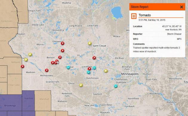
Saturday Supercells. AerisWeather data plotted above shows the location of funnel clouds and tornado touchdowns on Saturday (red). Hail reports show up as blue; 1″+ hail from near Willmar to Litchfield and Shakopee. There were also reports of significant straight-line wind damage. Specifics are here, courtesy of NOAA.
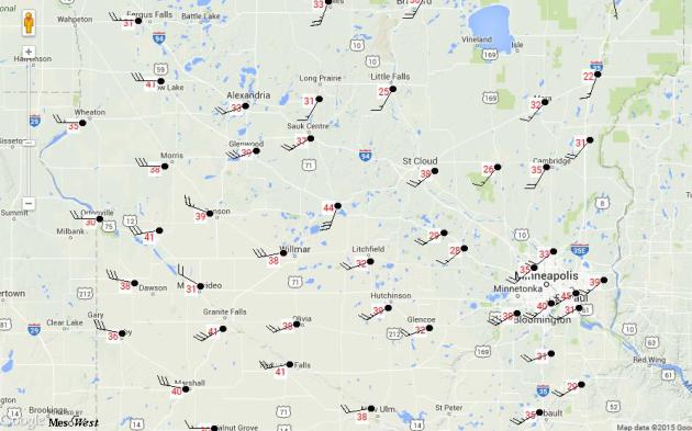
Wild Winds. The map above from MesoWest shows peak wind gusts at 10 PM last night; in the 40 mph range in the Twin Cities (tropical storm force). I saw winds gusting over 50 mph across far western Minnesota; a sharp drop in temperature whipping up the pressure gradient necessary for winds to howl.
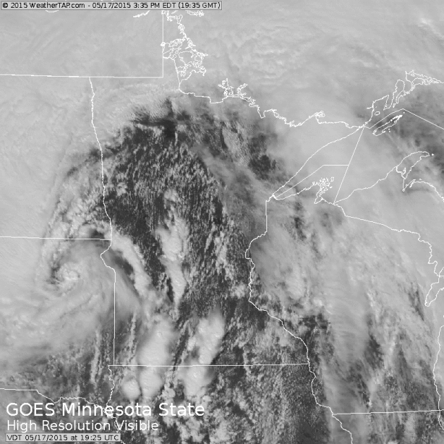
Dodging A Bullet. Sunday morning conditions looked favorable for a severe storm outbreak with high dew points and dry air wrapping around the center of low pressure in northeastern South Dakota providing a big shot of instability. But wind shear wasn’t sufficient for tornadic supercells; and the thunderstorms that did flare up were generally below severe criteria. Source: WeatherTap.
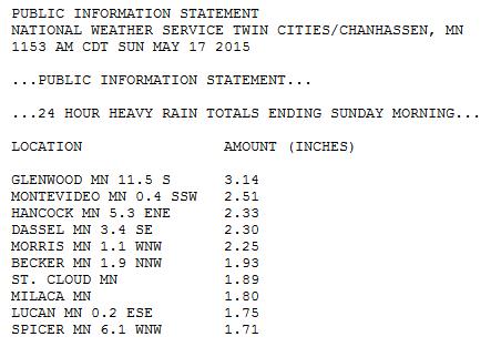
Weekend Soaker. A swirl of rain lingered over much of western and central Minnesota late Saturday into Sunday morning, resulting in some very significant rainfall amounts, in excess of 3″ at Glenwood, nearly 2″ at St. Cloud. It was a million dollar rain for farmers in central Minnesota.
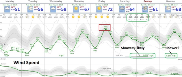
Slow Warming Trend. Today will feel more like early April with gusty winds and temperatures stuck in the 40s most of the afternoon; a generous smear of clouds overhead. The sun peeks out Tuesday and Wednesday as temperatures begin to recover. For the upcoming holiday Friday appears to be the best day with sunshine, light winds and highs topping 70F. Showers brush the state late Saturday into a portion of Sunday. We should dry out a bit on Memorial Day, but an isolated shower can’t be ruled out.

TODAY: Mostly cloudy, gusty & cool. Winds: NW 15-30. High: near 50 (40s most of the day).
MONDAY NIGHT: Clearing and chilly. Low: 39
TUESDAY: Bright sun, light breeze. High: 57
WEDNESDAY: Blue sky, next storm stays south. Wake-up: 43. High: 62
THURSDAY: Plenty of sun, pleasant. Wake-up: 45. High: near 70
FRIDAY: Lukewarm sun, leave office early. Wake-up: 49. High: 72
SATURDAY: Sunny start, showers late? Wake-up: 53. High: 70
SUNDAY: Unsettled, few showers likely. Wake-up: 55. High: 62
Climate Stories…

Jim Hightower: The Pope Gets It Right on Climate Change. The Winston-Salem Journal has an Op-Ed that caught my eye; here’s the introduction: “Some of corporate America’s biggest climate-change deniers — from Exxon-Mobil to the Koch Brothers — are dreading a potent storm that’s gaining strength and headed right at them. It’s the category-5 “Hurricane Francis,” which threatens to overwhelm their flimsy ideological castles. Rather than extreme weather, this has to do with a human who’s become a force of nature: Pope Francis...” (Photo credit: Steve Burns).
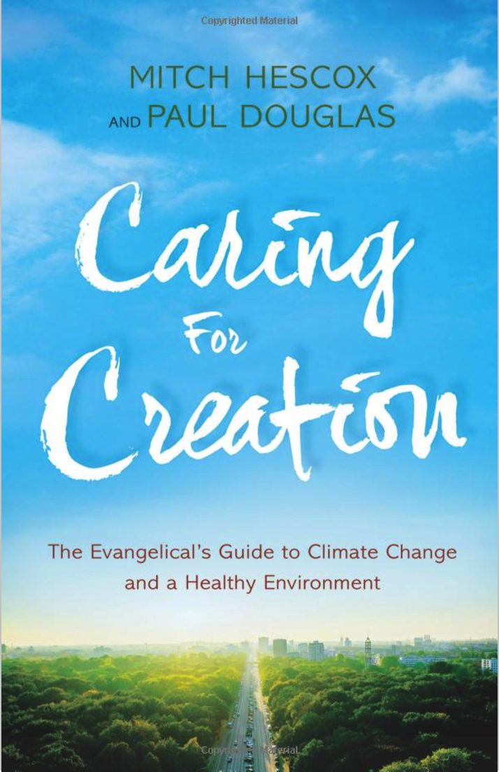
Read Paul’s New Book
Caring for Creation: The Evangelical’s Guide to Climate Change and a Healthy Environment