The Weather Blog
Daily weather updates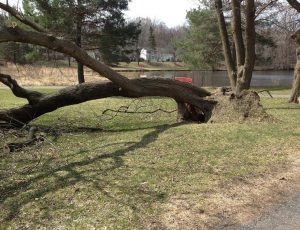
More Heavy Rain And Severe Storms Possible Thursday
Photo: Minnesota DNR
Do:
- Approach damaged trees with caution. Stay clear of downed wires and call 911.
- Carefully inspect standing trees for damage and deal with hazardous trees first. If possible, ask a forester or arborist for advice.
- Trees should be removed if more than 50 percent of the trunk or live branches in the crown are damaged, and if the tree is unnaturally leaning or roots are damaged.
- Watch for detached branches, loosely hanging branches and split or cracked trunks that can cause injury or further damage.
- Use proper pruning techniques to remove broken limbs by cutting just outside the branch collar, but limit pruning to making the tree safe. Too much pruning can weaken an already stressed tree.
- Water stressed and damaged trees weekly to help them repair and rebuild. Be careful not to overwater, especially in heavy clay soils.
- Monitor damaged trees in upcoming years to make sure they don’t become a hazard.
Don’t:
- Be rushed by promises of bargains from inexperienced or unqualified tree service providers. Improper pruning or unneeded removal can result in unnecessary costs or loss of healthy trees. Ask for references and proof of insurance.
- Repair a broken branch or fork of a tree with tape, wire, bolts or other wraps. It will not heal, and the split will invite decay and further weaken the tree. Cabling or bracing should only be performed by a certified arborist and inspected annually.
- Remove the tops of trees. This makes the tree more susceptible to insects and disease, and results in new branches that are weakly attached.
- Apply paint or dressing to wounds as these materials interfere with the natural wound sealing process.
- Remove small, leaning trees. Trees less than 15 feet tall may survive if they are gently pulled back into place. Press out air spaces in the loosened soil. The tree can then be staked for up to a year.
- Fertilize stressed or damaged trees.
_______________________________________________
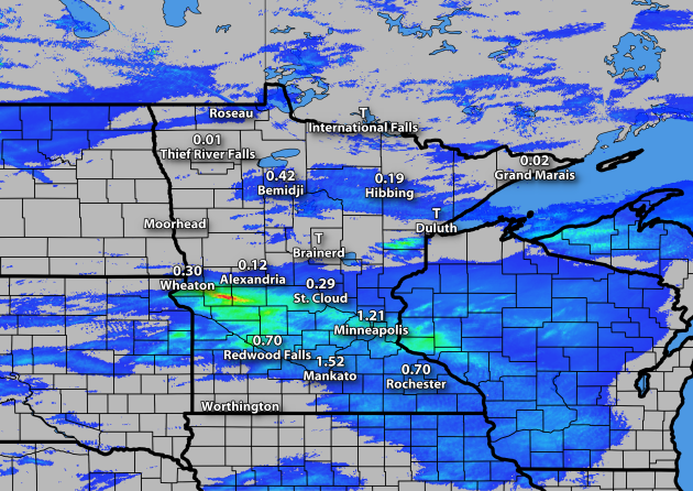
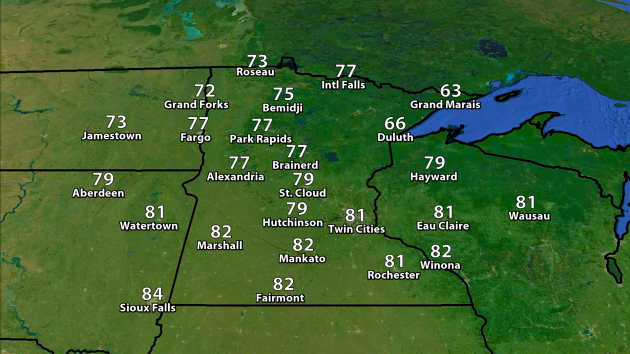
Rainfall Tuesday
Minnesota Crop Update
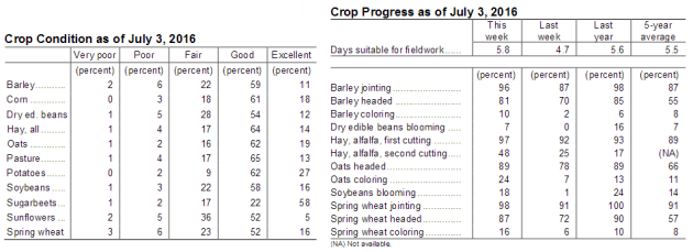
The latest crop update came out from the USDA Tuesday (delayed a day due to the Fourth of July holiday) and showed that most crops were still in good to excellent condition across the state. 79% of the corn crop was rated within those two categories, which was a decrease of 2% from the previous week. Meanwhile, almost half of the second cutting of alfalfa hay has been completed.
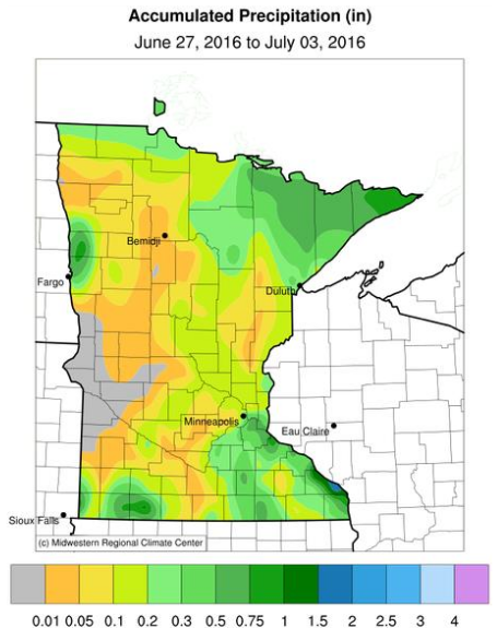
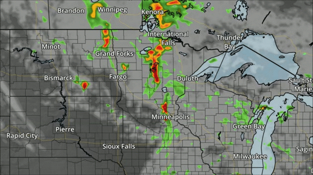
One story that came out of the report, however, were the dry conditions across the state. This is the rainfall map from June 27th through July 3rd, showing a good portion of the state saw less than an inch of rain during that time frame. Some parts of west-central Minnesota ended up with no rain. This has led to soils that are drying out and reports of some corn leaves rolling. The rain we saw Tuesday in parts of the state will hopefully help out the situation a little bit.
The Importance of Multiple Weather Safety Nets
By Paul Douglas
In a day and age when many people get their weather from smart phone apps – how can you tell the super-sized severe cells from garden-variety thundershowers? Tuesday’s outbreak in the Twin Cities was a reminder that there are often tip-offs beyond NWS watches and warnings.
When storms form a horseshoe-shaped arc on radar watch out for damaging winds. If you see a massive, lens-shape cloud lowering toward the ground – it might be time to visit the basement. Rotation, nearly continuous lightning, a greenish sky, all tip-offs that it’s time to get off the couch.
Don’t rely on only one source for warnings: sirens, NOAA weather radio, media, social media, apps; the more layers of information, the greater the odds you’ll get the warning in time.
A few T-storms may turn severe again today, but skies clear Friday with a push of cooler, drier air in time for the weekend. 70s Friday & Saturday give way to 80s Sunday and 90F Monday, according to ECMWF guidance. Fleeting glimpses of sweaty weather but no extended spells of torrid, Arizona-like heat the next 2 weeks. Not bad at all.
FRIDAY: Gusty and cooler, showers up north. High 77. Low 58. Chance of precipitation 20%. Winds NW 10-20 mph.
SATURDAY: Mostly sunny and pleasant. High 79. Low 61. Chance of precipitation 0%. Winds SE 8-13 mph.
SUNDAY: Warm sun, few T-storms far north? High 84. Low 70. Chance of precipitation 10%. Winds SE 10-15 mph.
MONDAY: Hot sun, T-storms arrive at night. High 90. Low 73. Chance of precipitation 40%. Winds S 10-20 mph.
TUESDAY: Morning thunder, then clearing. High 88. Low 72. Chance of precipitation 50%. Winds SW 5-10 mph.
WEDNESDAY: Unsettled, passing T-storm possible. High 85. Low 68. Chance of precipitation 30%. Winds NW 5-10 mph.
_______________________________________________
This Day in Weather History
July 7th
_______________________________________________
Average Temperatures & Precipitation for Minneapolis
July 7th
Average High: 84F (Record: 101F set in 1936)
Average Low: 64F (Record: 44F set in 1891)
Average Precipitation: 0.13″ (Record: 3.00″ set in 1955)
________________________________________________
Sunrise/Sunset Times for Minneapolis
July 7th
Sunrise: 5:35 AM
Sunset: 9:01 PM
*Length Of Day: 15 hours, 26 minutes and 36 seconds
*Daylight Lost Since Yesterday: ~1 mins & 9 secs
*Next Sunrise That Is Before 6 AM: August 3rd (6:01 AM)
*Next Sunset That Is Before 9 PM: July 11th (8:59 PM)
Thursday And Beyond Minnesota Weather Outlook
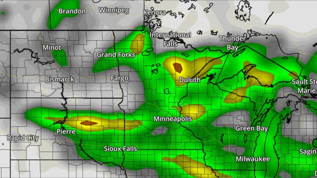
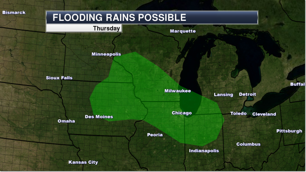
Another 1-2″ of rain is possible across much of the state Thursday with the storms as they move through. Of course, we could use the rain in parts of the state – however, on the back of already heavy rain Tuesday in parts of central/southern Minnesota, we don’t really need another quick 1-2″ on top of that.
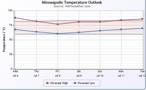
Here’s a look at the temperature trends over the next several days – staying pretty close to average for highs as we head into the middle of next week.
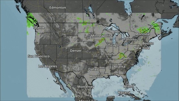
Strong to severe storms will be possible across the Great Lakes to the Mid-Atlantic Thursday. Meanwhile, a front will bring showers to parts of the Northwest.
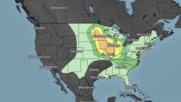
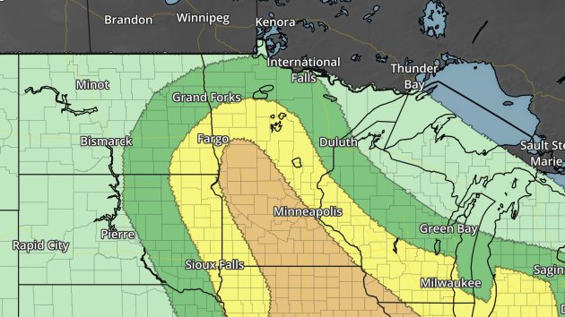
Severe risk Thursday. Dark green – marginal threat. Yellow – slight threat. Orange – enhanced threat.A Enhanced Risk of severe weather – including large hail and damaging winds – stretches from Minnesota to extreme western Indiana Thursday.
Thanks for checking in and have a great Thursday! Don’t forget you can follow me on Twitter (@dkayserwx) or on Facebook (Meteorologist D.J. Kayser)!
–D.J. Kayser

Read Paul’s New Book
Caring for Creation: The Evangelical’s Guide to Climate Change and a Healthy Environment