The Weather Blog
Daily weather updates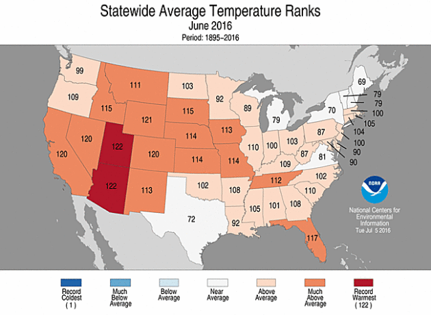
Slight Rain Chance Friday (Especially North) – Excellent Weekend Ahead
Looking Back At June
NOAA’s National Centers for Environmental Information released Thursday rankings for the month of June across the United States. June of 2016 ended up being the warmest on record (since 1895) for the contiguous U.S – and the warmest on record for Utah and Arizona. Meanwhile, here in Minnesota, it was the 31st warmest June on record.
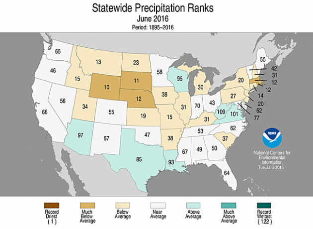
Meanwhile, average precipitation across Minnesota was near the middle of the rankings. However, you only need to look west of the state to find some of the driest Junes on record for the Dakotas and northern Rockies, and a very wet June to the east in Wisconsin.
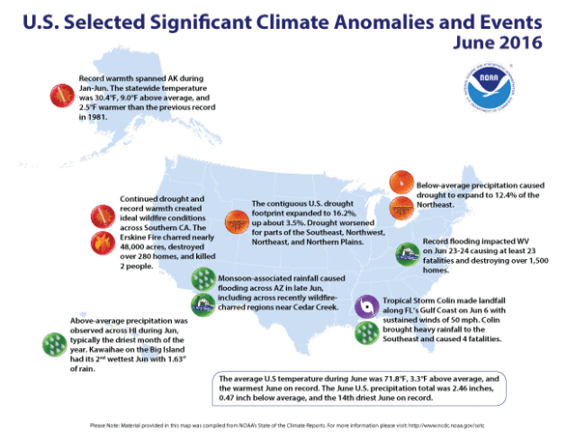
Here is a look at some of the larger weather events that occurred across the country last month. For more information, click over to the NCDC.
_______________________________________________
Drought Update
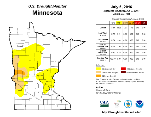
Drought has expanded since last week in Thursday’s Drought Monitor update from the USDA. Approximately a third of the state is now classified as “Abnormally Dry” including parts of the Twin Cities. We also saw an increase in areas under Moderate (~7%) and Severe (~1%) Drought categories across the state. The good news is that the data cutoff for each weeks drought update is 8 AM ET Tuesday, therefore it doesn’t include most of the rain that fell across the state Tuesday. That means we hopefully will see some improvement in the number next week.
SATURDAY: Sunny with less wind. High 80. Low 64. Chance of precipitation 10%. Winds SE 7-12 mph.
SUNDAY: Less sun, risk of a T-storm. High 83. Low 70. Chance of precipitation 50%. Winds S 10-15 mph.
MONDAY: Hot, sticky sun. Strong storms late? High 89. Low 73. Chance of precipitation 60%. Winds S 10-20 mph.
TUESDAY: Clearing skies, drying out a bit. High 90. Low 71. Chance of precipitation 20%. Winds SW 8-13 mph.
WEDNESDAY: Muggy, few more T-storms. High 87. Low 67. Chance of precipitation 50%. Winds S 10-15 mph.
THURSDAY: Partly sunny, cooler, less humid. High 79. Low 60. Chance of precipitation 10%. Winds NW 10-15 mph.
_______________________________________________
This Day in Weather History
July 8th
_______________________________________________
Average Temperatures & Precipitation for Minneapolis
July 8th
Average High: 84F (Record: 101F set in 1974)
Average Low: 64F (Record: 51F set in 1958)
Average Precipitation: 0.12″ (Record: 3.07″ set in 1925)
________________________________________________
Sunrise/Sunset Times for Minneapolis
July 8th
Sunrise: 5:35 AM
Sunset: 9:01 PM
*Length Of Day: 15 hours, 25 minutes and 22 seconds
*Daylight Lost Since Yesterday: ~1 mins & 13 secs
*Next Sunrise That Is Before 6 AM: August 3rd (6:01 AM)
*Next Sunset That Is Before 9 PM: July 11th (8:59 PM)
Friday And Beyond Minnesota Weather Outlook

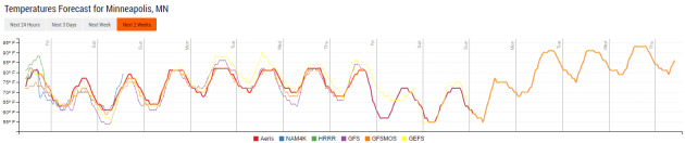
Here’s a look at the temperature trends over the next several days – we’ll see a warm up as we head into the weekend, with highs climbing back into the 80s. What is interesting to me is what looks to be a cool down heading into next weekend, with models currently hinting at highs only in the low to mid 70s. We’ll have to see if this trend holds up.
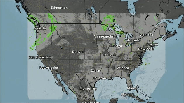
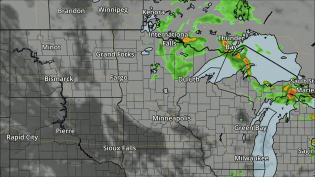
A front will bring a few showers to parts of the Northwest as we work our way through Friday. Meanwhile, storms can be expected to pop from the Central Plains into the Northeast.
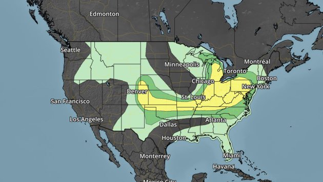
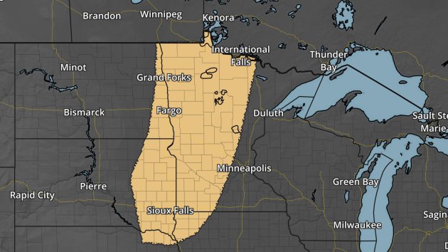
Severe risk Friday. Dark green – marginal threat. Yellow – slight threat.
A wide area of severe weather is possible Friday from the Northeast and Great Lakes into the Front Range of the Rockies. Large hail and damaging winds will be the main threats.
Los Angeles Rain
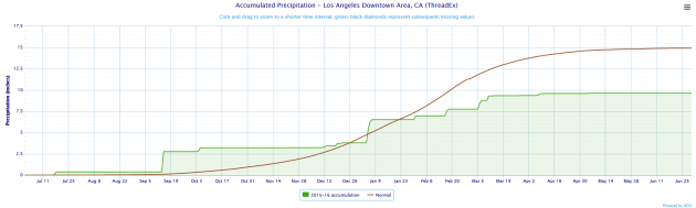
With drought continuing in California, it should be no surprise that the Los Angeles National Weather Service recently announced that the past five years have been the driest five-year period on record. More from the LA Times: “Having missed out on most of El Niño’s bountiful rains this winter, the Southland experienced yet another dreadfully below-average year of precipitation between July 1 and June 30. As a result, downtown Los Angeles recorded an average of just 7.75 inches of rain every year since July 2011, according to NWS meteorologist Scott Sukup. That’s a total five-year rainfall of just 38.79 inches – roughly half of the amount of rain that would soak L.A. in a normal five-year period, experts say.”
Warnings Since 2014
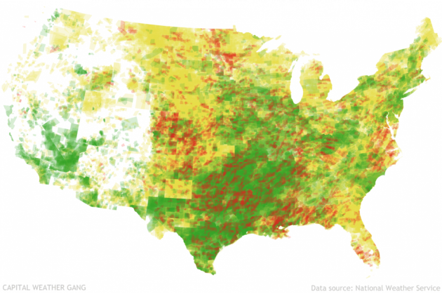
Image: Capital Weather Gang
Ian Livingston of the Capital Weather Gang put together a look at warnings issued by National Weather Service offices across the nation since 2014. Click for more charts and figures of warnings that have been issued, including the elusive “zero population” warning: “As someone fascinated with the warning process and how it is communicated to the public, I have followed the severe warning accounts since inception in June 2014. Seeking out the zero warning, or one with no ambient population, is actually something of a hobby. (I know, don’t judge.) Looking for more, I made a data request on what has been issued since the Twitter accounts became operational. I was fortunate enough to connect up with the National Weather Service, and they supplied the raw data they’ve obtained while developing these channels.”
Thanks for checking in and have a great Friday! Don’t forget you can follow me on Twitter (@dkayserwx) or on Facebook (Meteorologist D.J. Kayser)!
–D.J. Kayser

Read Paul’s New Book
Caring for Creation: The Evangelical’s Guide to Climate Change and a Healthy Environment