___________________________________________________________________________

_______________________________________________________________________________


.gif)

____________________________________________________________________


Heavy Snow in the Northeast on Thursday


____________________________________________________________________________
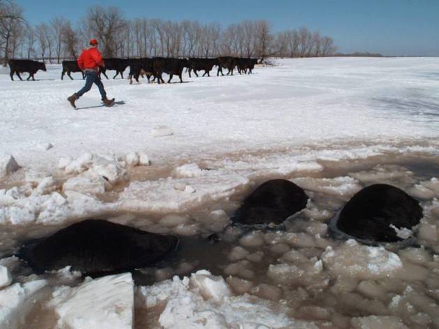
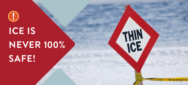
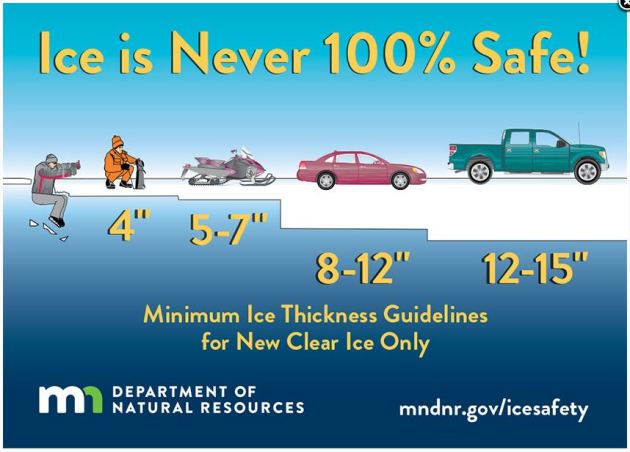
Under 4″ – STAY OFF
4″ – Ice fishing or other activities on foot
5″ – 7″ – Snowmobile or ATV
8″ – 12″ – Car or small pickup
12″ – 15″ – Medium truck
Many factors other than thickness can cause ice to be unsafe.
White ice or “snow ice” is only about half as strong as new clear ice. Double the above thickness guidelines when traveling on white ice.
___________________________________________________________________
.png)
.gif)
High Temps Friday
High temperatures on Friday will still be VERY cold across the eastern half of the country with reading runningi -10F to -30F below average! Some across the far north may not even warm above 0F. However, folks in the Western US will be warmer than average.


.gif)
According to NOAA’s WPC, the 5 day precipitation outlook suggests areas of heavier precipitation continuing across the West Coast though Tuesday. Some locations there could see several inches of liquid, which could lead to flooding. There also appears to be locally heavy rain across the Gulf Coast as we head into the weekend and early next week.
.gif)
.png)
1.) Much below-normal temperatures for the eastern U.S., Sun, Jan 7.
2.) Freezing rain for parts of the Ohio Valley, central Appalachians, and Mid-Atlantic, Mon, Jan 8.
3.) Heavy snow for the Sierra Nevada Mountains, Mon-Tue, Jan 8-9.
4.) Heavy rain for parts of southern California, Mon-Tue, Jan 8-9.
5.) High winds shifting east from the southwestern U.S. to the central and southern High Plains, Tue-Wed, Jan 9-10.
6.) High winds expanding from the Aleutians to the Alaska Peninsula and parts of southwest mainland Alaska, Sun-Tue, Jan 7-9.
7.) High significant wave heights for coastal portions of the Aleutians and Alaska Peninsula, Sun-Tue, Jan 7-9.
8.) A slight risk of heavy precipitation for the Pacific Northwest, Sun-Thu, Jan 14-18.
9.) Severe Drought across the Great Plains, the Southwest, the Middle and Lower Mississippi Valley, and Hawaii.
.png)
_____________________________________________________________________
Anything but average. Cold & Snowless
By Todd Nelson, filling in for Douglas.
The East Coast “Bomb” storm caused quite a ruckus earlier this week with wintry weather stretching from Florida to Maine. Some in the Northeast picked up a foot of snow with reports of thundersnow and near hurricane force wind gusts yesterday. Rare snow even fell across parts of the Southeast on Wednesday; Tallahassee, FL recorded 0.1 inches of snow, which is the first they’ve seen in 28 years! Get this, Summerville, SC saw 7.3 inches of snow, which is more than the Twin Cities has seen all season! Really? Yep!
The MSP Airport has only recorded 7.2 inches of snow this season, which since 1884 is the 26th least amount of snow we’ve had at the start of any snow season.
We enjoy another face-numbing day Friday with sub-zero wind chills values much of the day. A light snow chance arrives late Saturday with minimal snow accumulations by AM Sunday. Temps FINALLY look to warm back to near average by Sunday. ‘Warmer’ temps may actually help our snowfall potential. There’s a chance of mucky commutes late next week, but don’t hold your breath.
________________________________________________________________________
Extended Forecast
FRIDAY: Arctic sunshine. Winds: NNE 5. Wake-up: -8. High: 3.
FRIDAY NIGHT: Mostly clear and cold. Winds: Calm. Low: -11.
SATURDAY: Increasing clouds. Light snow overnight. Winds: SSE 5-10. High: 12.
SUNDAY: Warmer. AM flurries, peeks of PM sunshine. Winds: WNW 5-10. Wake-up: 7. High: 27.
MONDAY: Feels better. Not as nanook. Winds: NW 5-10. Wake-up: 15. High: 26
TUESDAY: Average for January. Clouds thicken. Winds: S 5-10.. Wake-up: 12. High: 24.
WEDNESDAY: Clouds thicken. Chance of snow late. Winds: SSW 5-10. Wake-up: 10. High: 27.
THURSDAY: Snow. Cold wind develops. Winds: N 10-20. Wake-up: 8. High: 20.
_______________________________________________________
This Day in Weather History
January 5th
2012: Record warmth is felt across the state. Many locations in western Minnesota soared over 50 degrees, with temperatures reaching the 60s at Marshall, Canby, and Madison. This was the first record of any 60 degree temperatures in Minnesota during the first week of January.
_______________________________________________________
Average High/Low for Minneapolis
January 5th
Average High: 24F (Record: 47F set in 1885)
Average Low: 8F (Record: -28F set in 1924)
Record Rainfall: 0.63″ set in 1932
Record Snowfall: 4.7″ set in 1994
_________________________________________________________
Sunrise/Sunset Times for Minneapolis
January 5th
Sunrise: 7:51am
Sunset: 4:46pm
Hours of Daylight: ~8 hours 55 mins
Daylight GAINED since yesterday: ~ 1 minute & 8 seconds
Daylight GAINED since winter solstice (December 21st): 9 minute
__________________________________________________________
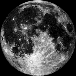
Moon Phase for January 5th at Midnight
2.6 Days Before Last Quarter Moon
_________________________
High temps on Friday will still be quite cold across much of the region with readings still nearly -10F to -20F below average! The good news is that Friday looks like the last really cold day before we warm up heading into the weekend.


Here’s the temperature outlook as we head into the 3rd week of January, which suggests colder than average temperatures may linger across the Great Lakes and Ohio Valley. However, warmer than average temperatures will move in across the High Plains.

8 to 14 Day Temperature Outlook
Here’s the extended temperature outlook from January 13th to January 17th, which suggests colder than average temperatures lingering across parts of the Central US from the Great Lakes to the Southern US. Warmer than average temperatures will start to make a return across much of the Western US during the middle part of the month.

“What had been a warmer than normal December, with the first 22 days averaging nearly 4.8 degrees above normal, was transformed to slightly below normal by a dramatic cold wave to end the month. Over the last week of December we averaged about 11 degrees below normal. This sudden change, though not unprecedented, was foreseen in various medium-range forecasts made before Christmas. But it has captured the nation’s attention as 2017 draws to a close. Unfortunately, some of that attention may contribute to misunderstanding — motivated by President Trump’s recent statement suggesting such a cold wave provides evidence that his administration’s denial of climate change has been vindicated. Defense of the reality of global warming is particularly challenged by the cherry-picking skeptic during winter, as any period of below-average temperatures, and every winter will have some, is construed as evidence to the contrary.”
See more from CIMSS The WX Guys HERE:

________________________________________________________________________

___________________________________________________________________________

______________________________________________________________________________
.jpg)
____________________________________________________________________________

____________________________________________________________________________

___________________________________________________________________________

____________________________________________________________________________

_____________________________________________________________________________

____________________________________________________________________________