80 Degrees Possible On Friday
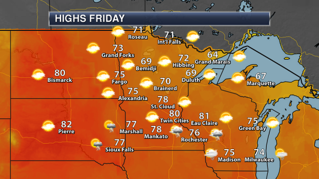
Ready to enjoy some August weather in the second half of October? It is on its way to parts of the state Friday, with highs in the 70s and potentially touching 80 in areas on Friday! The forecast high right now for the Twin Cities Friday is 80.
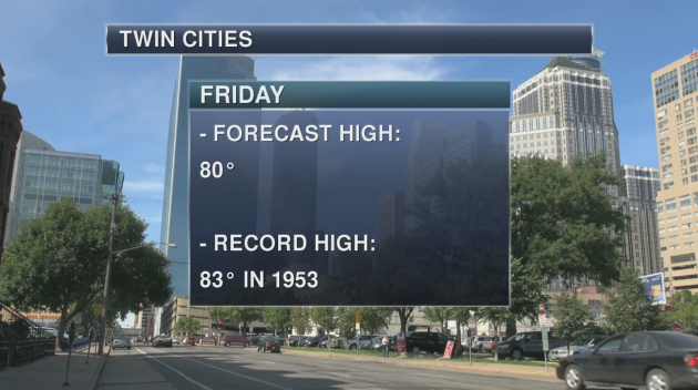
That high of 80 expected Saturday in the Twin Cities will actually approach the record for the day of 83 set back in 1953.
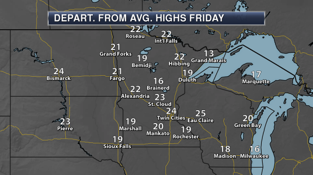
In many areas of the state, highs will be 15-25 degrees above average on Friday. This will certainly be some nice weather for the second half of October across the region… especially when we could have snow falling instead!
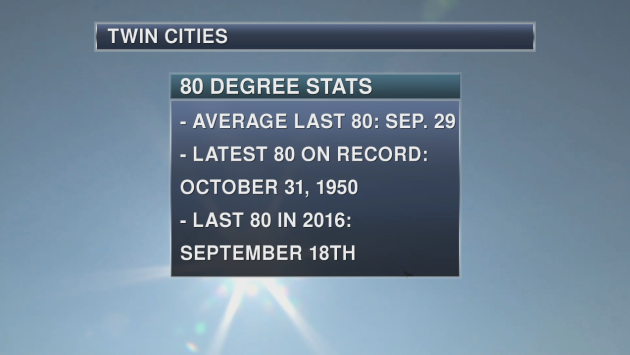
If the Twin Cities did hit 80 on Friday, it would be one of the latest last 80s on record as only ten other years have had a later date that the last 80 occurred on. The last average 80 on record (looking over the entire Twin Cities record) occurs on September 29th. Meanwhile, it was quite a warm Halloween in 1950 as that is the date of the latest 80 on record. Last year, the last 80 was on September 18th. The last time we saw a high that was 80 or higher this year was back on September 24th when the high reached 90.
_______________________________________________
Weather That Makes the Chamber of Commerce Proud
By Paul Douglas
If only this could last, right? Embrace and memorize the good times – power through the bad. Factoring dew point, bug count and allergy index you could make a strong case that the next 2 days will feature some of the finest weather of the year. 80F is not out of the question Friday afternoon; the average high on August 21.
Unusual but hardly unprecedented. On this date in 2000 the mercury hit 84F in the Twin Cities and 90F at Appleton. But the pendulum can just as easily swing in the opposite direction. On October 19, 1972 the mercury sank to 9F in Luverne and St. Peter.
Shorts on Friday give way to umbrellas Saturday as an eastbound cool front sparks a few showers and thundershowers. Sunday will be the sunnier, drier, better day of the weekend for outdoor plans.
A quick swipe of chilly air Tuesday gives way to a stronger, deeper push of Canadian air late next week. The first widespread frost/freeze of the season is likely late next week; possibly the first flurries of the winter season.
When the weather is this nice, for this long, expect the other shoe (boot) to drop!
_______________________________________________
Extended Twin Cities Forecast
THURSDAY: Sunny and beautiful. High 73. Low 53. Chance of precipitation 0%. Wind S 8-13 mph.
FRIDAY: Sunny with a warm wind. High 80. Low 60. Chance of precipitation 10%. Wind S 15-25 mph.
SATURDAY: Few showers and thundershowers. High 71. Low 47. Chance of precipitation 70%. Wind S 10-20 mph.
SUNDAY: Partly sunny, nicer day of the weekend. High 63. Low 50. Chance of precipitation 10%. Winds W 8-13 mph.
MONDAY: More clouds, few light showers. High 60. Low 43. Chance of precipitation 40%. Winds NW 10-15 mph.
TUESDAY: Cool sunshine, light jackets return. High 53. Low 38. Chance of precipitation 10%. Winds NW 10-15 mph.
WEDNESDAY: Partly sunny, trending milder. High 60. Low 37. Chance of precipitation 10%. Winds SW 8-13 mph.
_______________________________________________
This Day in Weather History
October 19th
2000: The warmest October 19th in Minnesota history occurs for many towns. Many cities had highs in the 80s, with the Twin Cities hitting 84. Appleton in Swift County reported 90 degrees.
1972: A cold snap moves through Minnesota, with lows of 1 above in Tower and 9 in St. Peter and Luverne.
1916: Redwood Falls receives a record-setting 7 inches of snow.
_______________________________________________
Average Temperatures & Precipitation for Minneapolis
October 19th
Average High: 57F (Record: 87F set in 2000)
Average Low: 39F (Record: 15F set in 1972)
Average Precipitation: 0.07″ (Record: 2.75″ set in 1934)
________________________________________________
Sunrise/Sunset Times for Minneapolis
October 19th
Sunrise: 7:34 AM
Sunset: 6:20 PM
*Length Of Day: 10 hours, 46 minutes and 27 seconds
*Daylight Lost Since Yesterday: ~2 minute and 59 seconds
*Latest Sunrise Before Daylight Saving Time Ends: November 4th (7:56 AM)
*Next Sunset At/Before 6:00 PM: November 1st (6:00 PM)
_______________________________________________
Minnesota Weather Outlook
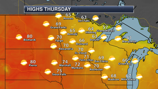
Another warm, beautiful day is expected Thursday with temperatures in the low to mid 70s in central and southern Minnesota and mainly sunny skies. Many areas of northern Minnesota should make it into the 60s, but Grand Marais looks to stay in the 50s.
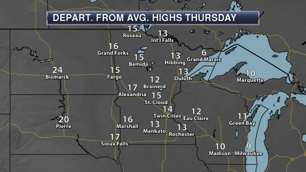
Across most of the state, highs will be 10-15 degrees above average for this time of year Thursday.
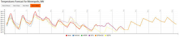
Enjoy the nice weather through the end of the week (including that 80 degree day mentioned above on Friday) as a change will be coming as we head into the weekend. A cold front will pass through Saturday, bringing the chance of some thunder with it along with cooler temperatures. Another front will move through early next week. Both of these fronts will help usher in some of the coolest weather so far this season into the region, with highs only in the 50s by next Tuesday in the Twin Cities.
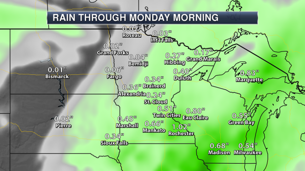
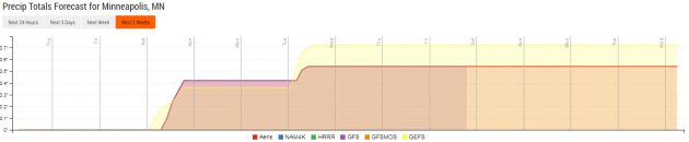
A cold front moving through Saturday will bring the best chance of accumulating rain since last weekend to the state. Rainfall amounts in the Twin Cities are expected to be around a half an inch, with higher amounts expected across parts of southern Minnesota into Wisconsin. Showers will be possible as early as the morning hours Saturday across southern Minnesota, with a few thunderstorms possible during the afternoon.
A second chance of rain exists in the extended outlook as we head into next week with that second cold front that moves through. I hate to say this… but there is even the chance of a few snowflakes across portions of the state next Tuesday.
_______________________________________________
National Weather Outlook
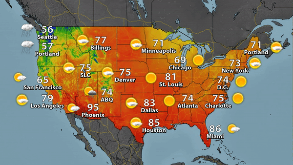
Rain and high elevation snow will continue across the Pacific Northwest into the day on Thursday as a cold front moves through the region – even as far south as northern California. We could see some flooding from this rain, as some mountain ranges could pick up a half an foot or more of rain through the end of the week. A low pressure center could bring some showers and storms to parts of the desert Southwest Thursday. A few showers and storms will be possible along the Texas coast by the evening hours. Meanwhile, a stalled front will bring parts of Florida more scattered showers and storms. Most of the rest of the nation will see mainly sunny skies and fairly warm temperatures for this time of year.
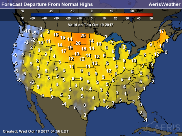
Highs across many areas of the nation Thursday will be above average for this time of year, with the greatest departure from averages found in the Northern Plains and New England. With that cold front coming onshore along the west coast, highs will be slightly below average.
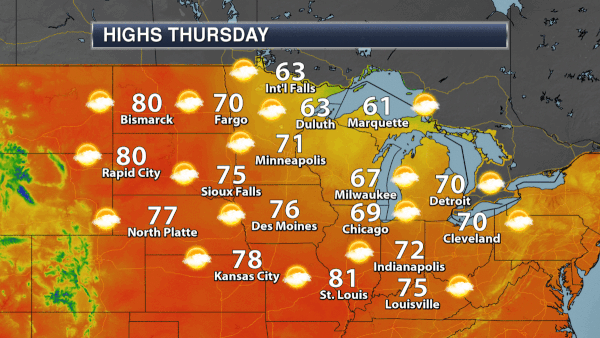
Temperatures will be warming across the upper Midwest the next couple days, with highs approach 80 in Bismarck and Rapid Citiy Tuesday, then reaching that same mark Friday in the Twin Cities. However, you can see that cold front moving through the region this weekend, quickly dropping highs behind it by at least 10-20 degrees. Another cold front early next week will bring even cooler air into the region.
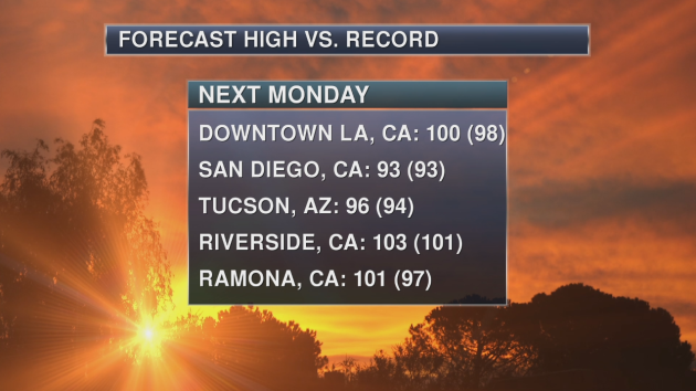
We are expecting high pressure to build into the Great Basin this weekend. This will lead to quickly warming temperatures across the Southwest, with record highs possible for areas like Los Angeles, San Diego and Tucson by Monday.
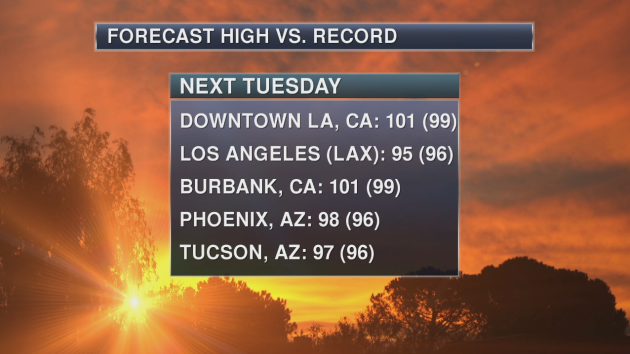
Record highs will continue into Tuesday across the region, including in Los Angeles, Phoenix and Tucson.
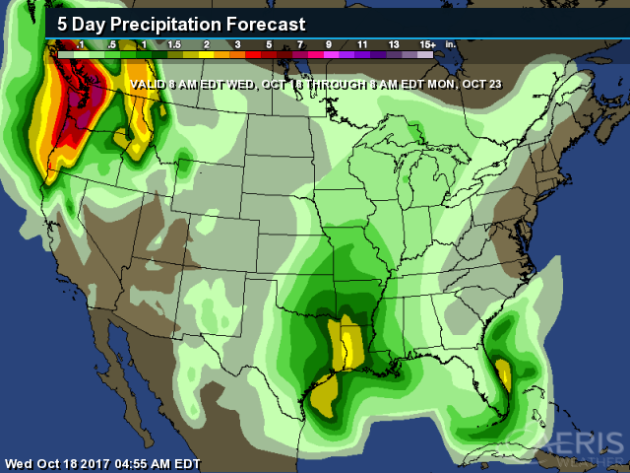
The heaviest rain over the next five days (through the weekend) will be across the Northwest, where we’ll watch several systems move through. Some heavy rain will also be possible across parts of the southern Plains/lower Mississippi Valley as a system moves through during the weekend, potentially bringing more than 2″ of rain to the region.
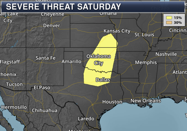
As a system passes through parts of the southern and central Plains this weekend, some severe weather will be possible Saturday from Kansas to the Dallas area. Damaging winds would be the main threat with any severe storms.
_______________________________________________
More Lightning In Shipping Lanes?
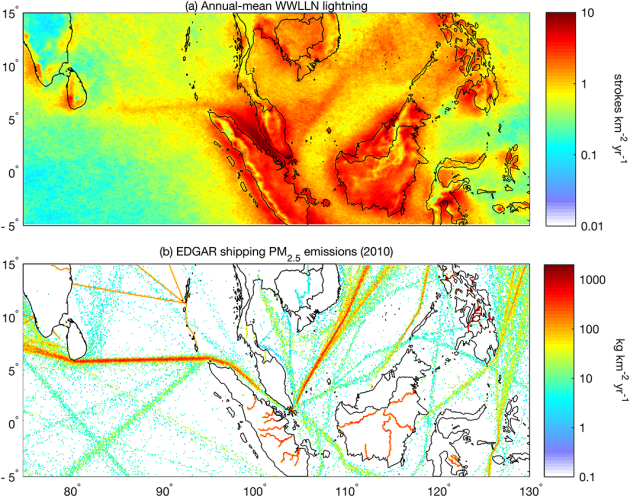
That’s the conclusion based off a recent study, and it has to do with pollution those ships produce. More from Scientific American: “When lightning sparks across the sky, it sends out low-frequency radio waves that researchers can use to determine its location. Recently, scientists were looking over a map of lightning activity, when they noticed something strange: narrow lines of increased lightning frequency stretching across the Indian Ocean and the South China Sea. Straight features like these are rare on a spherical, spinning planet, except where humans are up to something. In this case, sending ships across the sea.” (Image: Observed annual-mean WWLLN lightning density for 2005–2016 in the eastern Indian Ocean and the South China Sea. (b) PM2.5shipping emissions estimates from EDGAR database for 2010, both at 0.1° resolution. From Joel A. Thornton et al, Lightning enhancement over major oceanic shipping lanes)
New Danger After California Fires

After the recent California wildfires comes a new danger: hazardous debris. California OES News has more: “Statewide wildfires that scarred communities across Northern and Southern California now pose a new threat. As changing weather patterns and tireless work of more than 11,000 firefighters boost containment lines, communities devastated by the fires face potential health risks associated with the improper handling of fire debris.”
Electrical Problems In Puerto Rico
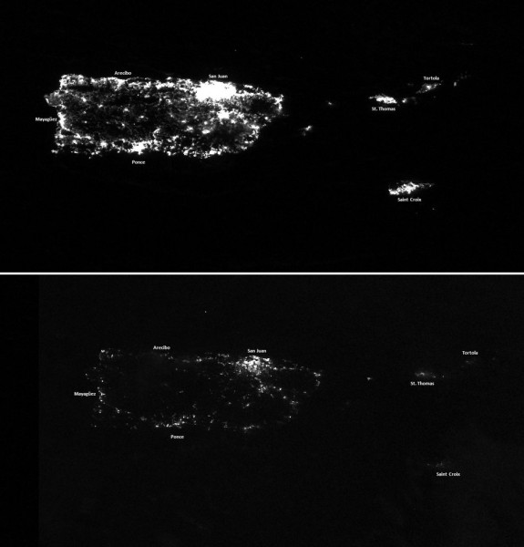
FiveThirtyEight took a dive into why the electrical grid has been a problem in Puerto Rico – long before Maria ever struck the island – and why there will be troubles for potentially years to come: “More than two weeks after Hurricane Maria crashed into Puerto Rico on Sept. 20, Allan Rivera had still not had a full night’s sleep. “Every three hours … I get up and do some maintenance on the generator,” he told me. His wife — who has multiple sclerosis — relies on air conditioning to help minimize her symptoms, but Toa Baja, the town where he lives on the island’s north coast, was still without electricity. That meant Rivera had to keep a gasoline-powered generator running 24 hours a day, seven days a week.” (Image: Aerial photographs of Puerto Rico before and after Hurricane Maria. NOAA)
Jones Act Could Affect Offshore Wind Market
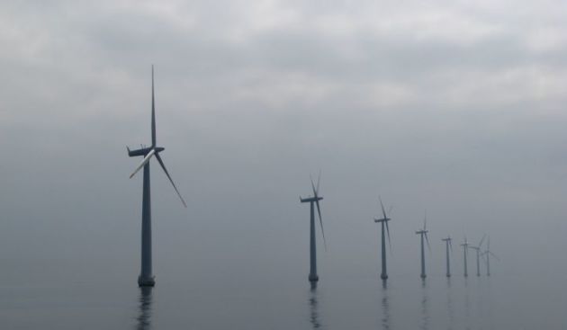
The same government act that had to be revoked so more goods could get to Puerto Rico after Maria could pose a problem for future offshore wind power. More from GreenTechMedia: “The U.S. has lagged behind Europe in building offshore wind for decades. That’s often attributed to uncompetitive pricing and lack of political will. But as more developers work to get U.S. offshore wind projects off the ground in the coming years, the century-old Jones Act has raised concerns that even with improving economics and technological innovation, the process could remain onerous and the costs exorbitant.” (Image: Offshore wind farm near Samsø, Denmark. Photo Credit: Flickr/m.prinke)
“Green” Bond For Fiji
A new bond from Fiji will specifically raise funds to combat climate change in the country. More from Reuters: “Fiji will issue a $50 million “green” bond in coming weeks to help combat the effects of global climate change, the first developing country to do so, its prime minister said on Wednesday. The Pacific Island nation is seen as particularly vulnerable to climate change, with some of its 300 low-lying islands susceptible to rising seas.”
_______________________________________________
Thanks for checking in and have a great Thursday! Don’t forget to follow me on Twitter (@dkayserwx) and like me on Facebook (Meteorologist D.J. Kayser)!
– D.J. Kayser

