_______________________________________________________________

____________________________________________________________________________
_________________________________________________________________________

_______________________________________________________________________________

_________________________________________________________________________ Tropical Heat Wave – Minnesota Style…


__________________________________________________________________________
.gif)

____________________________________________________________________
“The term “weather bomb” has been making the rounds lately, appearing on the front page of newspapers and the top of television news cycles. Despite this phrase only recently entering household conversation, the meteorological definition of the “bomb” has been around for decades. John R. Gyakum, a professor of atmospheric science at McGill University in Montreal, is one of two authors who coined the nickname and studied the phenomenon behind the “bomb” in the 1980s. In an interview this week, Gyakum shared his thoughts with The Washington Post about how the name came to be. When did the term come about, and how was “bomb” selected? It came from a paper we published in 1980. The title was “Synoptic-Dynamic Climatology of the ‘Bomb.’ ” I was a graduate student at the time [at MIT], and my adviser, who was the lead author, Frederick Sanders, actually coined the term. He had quite a bit of experience making forecasts for cyclones in the North Atlantic that were developing very rapidly. Oftentimes, we’d even say explosively. Given their explosive development, it was an easy path to take to just call these systems “bombs.”
See more from Washington Post HERE:

__________________________________________________________________________

_______________________________________________________________________


_____________________________________________________________________________

______________________________________________________________________________

__________________________________________________________________________


____________________________________________________________________________
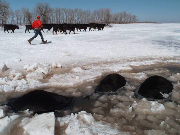
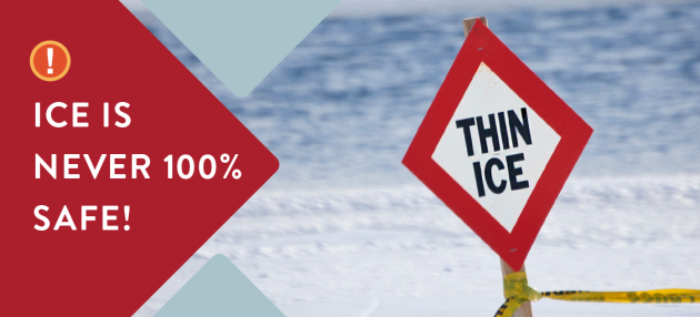
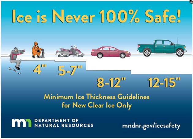
General Ice Thickness Guidelines
Under 4″ – STAY OFF
4″ – Ice fishing or other activities on foot
5″ – 7″ – Snowmobile or ATV
8″ – 12″ – Car or small pickup
12″ – 15″ – Medium truck
Many factors other than thickness can cause ice to be unsafe.
White ice or “snow ice” is only about half as strong as new clear ice. Double the above thickness guidelines when traveling on white ice.
___________________________________________________________________
.png)
.gif)
High Temps Sunday
We’ll start seeing signs of warmer temps moving in across the nation by Sunday. While much of the Eastern US will still be well below average, look at how much of the western half of the country will be above average!


.gif)
According to NOAA’s WPC, the 7 day precipitation outlook suggests areas of heavy precipitation across the Western US with several inches of liquid possible along the coast and in the high elevations. Some could be dealing with flooding as we head through the week. There will also be areas of heavier precipitation in the eastern half of the country, especially in the Lower Mississippi Valley where thunderstorms maybe possible.
.gif)

1.) Freezing rain for parts of the central Appalachians and Mid-Atlantic, Mon, Jan 8.
2.) Heavy snow for the Sierra Nevada Mountains, Mon-Tue, Jan 8-9.
3.) Heavy rain for parts of southern California, Mon-Tue, Jan 8-9.
4.) High winds shifting east across southern California and the southwestern U.S., Tue-Wed, Jan 9-10.
5.) Much below-normal temperatures shifting east from the northern Great Plains to the upper Mississippi Valley, Wed-Fri, Jan 10-12.
6.) Heavy precipitation for the Pacific Northwest, Thu-Fri, Jan 11-12.
7.) High winds expanding from the Aleutians to the Alaska Peninsula and parts of southwest mainland Alaska, Mon-Tue, Jan 8-9.
8.) High significant wave heights for coastal portions of the Aleutians and Alaska Peninsula, Mon-Tue, Jan 8-9.
9.) A moderate risk of heavy precipitation (rain and high-elevation snow) for parts of the Pacific Northwest and northern Sierra Nevada Mountains, Sat-Fri, Jan 13-19.
10.) A slight risk of heavy precipitation (rain and high-elevation snow) for the Pacific Northwest, northern Great Basin, and northern California, Sat-Fri, Jan 13-19.
11.) Severe Drought across the Great Plains, the Southwest, the Middle and Lower Mississippi Valley, and Hawaii.
.png)
_____________________________________________________________________
A “Cleveland Browns Winter”? Big Thaw Brewing
By Paul Douglas
A caller on our WCCO Radio Show framed the question in a way that got my attention. “Paul, is this going to be another Cleveland Browns winter?” Of course the Browns finished 0-16 in the AFC North this season.
A snowstorm is a fragile thing, a delicate dance of cold air and moisture. Too much cold air (Exhibit A: the last 2 weeks) and the storm track is shoved too far south and east for heavy snow here. Too much moisture and accompanying warmth usually means a mix or rain.
When you see storms pushing into California it often means a better chance of snow for Minnesota. That shift in the pattern may unfold the last week of January. Until then just garden-variety spits of snow, but snow lovers: don’t panic just yet.
The big story is an extended thaw; daytime highs above 32F for four days this week. 40F by midweek? Downright sweaty.
According to NOAA the MSP metro just enjoyed 9 days in a row of subzero fun. It’s not even close to a record. 2014 brought 17 consecutive nights below 0F. The record? 36 in 1936.
But we’ve earned a January Thaw this year, though. No question.
________________________________________________________________________
Extended Forecast
SUNDAY: Mostly cloudy, milder. Winds: SW 7-12. Wake-up: 10. High: 29.
SUNDAY NIGHT: Mostly cloudy. Winds: WSW 5. Low: 20.
MONDAY: Mix of clouds and sun, balmy. Winds: W 7-12. High: 35
TUESDAY: Patchy clouds and fog. Winds: S 7-12.. Wake-up: 25. High: 38.
WEDNESDAY: Overcast. A little drizzle late. Winds: S 7-12. Wake-up: 30. High: 41.
THURSDAY: Rain ends as a little wet snow. Winds: NW 10-20. Wake-up: 31. High: 33.
FRIDAY: Sunny start. Chance of snow late. Winds: SE 5-10. Wake-up: -3. High: 13.
SATURDAY: Light snow and flurries May be icy. Winds: NW 10-15. Wake-up: 3. High: 10.
_______________________________________________________
This Day in Weather History
January 7th
2003: Record warmth develops over Minnesota. Many places reached the 50s, including the Twin Cities. St. James hit 59 and the Twin Cities reached 51. Nine golf courses were open in the Twin Cities and 100 golfers were already at the Sundance Golf Course in Maple Grove in the morning.
1873: A storm named the ‘Great Blizzard’ hits Minnesota. This three-day blizzard caused extreme hardship for pioneers from out east who were not used to the cold and snow. Visibility was down to three feet. Cows suffocated in the deep drifts and trains were stuck for days. More than 70 people died, and some bodies were not found until spring. Weather conditions before the storm were mild, just like the Armistice Day storm.
_______________________________________________________
Average High/Low for Minneapolis
January 7th
Average High: 23F (Record: 52F set in 2003)
Average Low: 8F (Record: -34F set in 1887)
Record Rainfall: 0.30″ set in 1989
Record Snowfall: 3.6″ set in 1989
_________________________________________________________
Sunrise/Sunset Times for Minneapolis
January 7th
Sunrise: 7:50am
Sunset: 4:49pm
Hours of Daylight: ~8 hours 58 mins
Daylight GAINED since yesterday: ~ 1 minute & 17 seconds
Daylight GAINED since winter solstice (December 21st): 12 minute
__________________________________________________________
Moon Phase for January 7th at Midnight
0.6 Days Before Last Quarter Moon
.gif)
_________________________
High temps on Sunday will be MUCH warmer than it has been over the last couple of weeks. This will likely be some of the warmest weather we’ve seen since just before Christmas! Highs across the state of MN will be nearly +5F to +20F above average!


Here’s the temperature outlook as we head into the 3rd week of January, which suggests that warmer than average temperatures will be in place across much of the Midwest! This will feel amazing compared to what many of us have endured over the last couple of weeks.

8 to 14 Day Temperature Outlook
How the tides have turned! Here’s the extended temperature outlook from January 15th to January 19th, which suggests warmer than average temperatures across much of the nation! This will be a dramatic shift in what many of us had over the last couple/few weeks!


___________________________________________________________________________
1. Mars. The north and south pole of Mars have ice caps that grow and shrink with the seasons. These ice caps are made mainly of water ice—the same kind of ice you’d find on Earth. However, the snow that falls there is made of carbon dioxide—the same ingredient used to make dry ice here on Earth. Carbon dioxide is in the Martian atmosphere and it freezes and falls to the surface of the planet as snow. NASA’s Mars Reconnaissance Orbiter takes photos of the sand dunes around Mars’ north pole. The slopes of these dunes are seasonally covered with carbon dioxide snow and ice.”

__________________________________________________________________________“We’re three million miles closer to the sun in January than we are in July. So why isn’t it hot?”
“It turns out proximity is pretty inconsequential. There’s something about the geometry of space that’s never quite made sense to me. I know that the axial tilt of the Earth is the reason we have seasons, but if a slight angle away from the sun can make me see my breath in winter, why does being three million miles closer not make me melt in a pool of my own sweat? Is it really not any hotter when we’re at our shortest distance from our star? And if it is, then why should the 23.5° tilt to our axis matter at all? I have to re-Google these questions every year at the perihelion, the point at which we’re the closest to the sun. Despite December 21 being the shortest day of the year in the northern hemisphere, it’s not until early January that we reach perihelion, when Earth gets the most intense dose of solar rays it will receive all year. Averaged across the whole globe, we’re getting sunlight 7-percent stronger in January than we are in July.”
See more from Popular Science HERE:

___________________________________________________________________________“Insurers to pay out record $135 billion for 2017 after hurricanes”
“Insurers will have to pay claims of around $135 billion for 2017, the most ever, following a spate of hurricanes, earthquakes and fires in North America, according to a report published on Thursday. German reinsurer Munich Re, in its annual natural catastrophe review, also said last year’s total losses, including those not insured, were $330 billion, the second-worst in history after 2011 when an earthquake and tsunami wreaked havoc in Japan. Although individual events could not be linked directly to climate change, global warming is playing a role, Munich Re said. It expected more frequent extreme events in future. “We have a new normal,” said Ernst Rauch, head of Munich Re’s Corporate Climate Centre, which monitors climate change risks. “2017 was not an outlier,” he said, noting insured losses have surpassed $100 billion multiple times since 2005. “We must have on our radar the trend of new magnitudes.”

____________________________________________________________________________
“8 strange ice formations”
“Mother Nature has turned making ice into an art form, complete with abstract and impressionist movements. When it’s cold enough for water to turn from liquid to solid, odd things can happen. Indeed, odd things can also happen when temperatures are just right for water to turn from solid to gas, skipping the liquid part entirely. Or when the wind blows at just the right speed, or water moves at just the right pace. In other words, when conditions are just perfect for strange, we get the following unusual ice formations.”
See more from Mother Nature Network HERE:

______________________________________________________________________________