The Weather Blog
Daily weather updates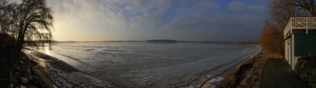
Trace of Snow on Ground at MSP, 37-40″ on Ground at Boston. How Warmer Ocean Water is Fueling Record Snows
33 F. high in the Twin Cities Monday.
27 F. average high on February 9.
9 F. high on February 9, 2014, after waking up to -7.
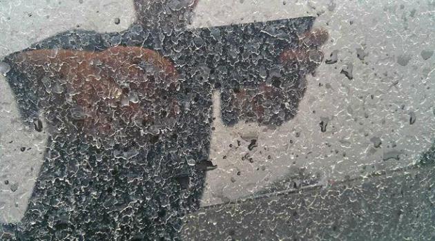
Trace of snow on the ground at KMSP as of Monday evening at 7 PM.
February 9 in Minnesota Weather History. Source: Twin Cities National Weather Service:
1965: Snowstorm dumps 15 inches of snow at Duluth over two days.
1861: Ice storm near Elk River. Coatings of a 1/2 inch of ice reported. The ice broke off many large branches and saplings were bent to the ground.
1857: Extreme cold at Fort Ripley. E.J. Baily, Assistant Surgeon notes : “Spirit thermometer -50 at 6am. Mercury frozen in charcoal cup. Spirit thermometer at Little Falls 16 miles from the fort -56 at 6am. The lowest degree of cold on record in the territory.
Chirp Chirp
Signs of spring are popping up, a bit prematurely I fear. My tax accountant is leaving me cryptic messages. A pale white light is now visible at breakfast and dinner! Progress. And yesterday a few cardinals were chirping a happy tune outside my bedroom window. They may be jumping the gun.
January was milder than normal, based on a rolling 30-year average at MSP. February is 2.4F colder than average, and it’s about to get even colder.
Arctic air doesn’t arrive all at once, it comes in waves, like breakers on the beach; each one larger than the one before. Temperatures slip below zero Thursday, over the weekend – with an even colder surge by the middle of next week. Expect 4 subzero nights in the next week. Numbing, but probably not school-closing cold. Unlike last winter I see no evidence of polar air stalling nearby, no perpetual blocking pattern capable of long-term polar pain.
The approach of cold front number one sparks a period of snow this afternoon; a quick inch or two possible with more north of MSP.
I have new respect for what a lousy inch of snow can do to our highways at 10-15F, but with highs today near 30F most freeways should be wet & slushy. In theory.
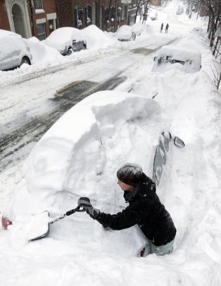
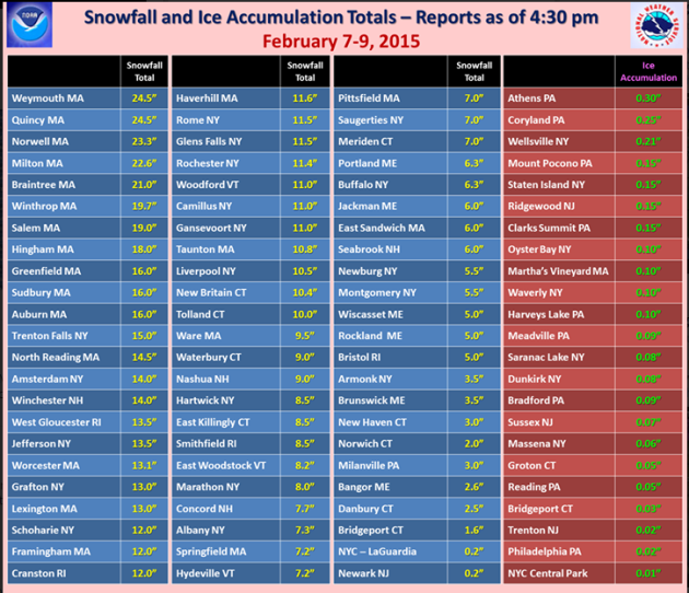
Staggering Amounts Of Snow in Boston. Over 22″ from this last storm, on top of the 4 feet of snow that has fallen in the previous 2 weeks. USA TODAY has an article that made me think of Buffalo’s ordeal back in December. This is what happens when unusually warm ocean water mixes with bitterly cold air pouring out of Canada – record snow events. Here’s an excerpt: “…Monday’s snow depth in Boston was 37 inches, which was the city’s largest depth ever recorded since weather records began. The National Weather Service’s Boston office said on Twitter that the city has received 76.5 inches of snow so far this winter. But nearby Providence, R.I., got just 4.2 inches of snow from this storm, the weather service reported. Boston set a record for the most snow recorded in a 30-day period, with 71.8 inches, breaking the record of 58.8 inches set in February 1978…”
Photo credit above: “Taylor LaBrecque digs her car out of a snow pile on Beacon Hill Monday, Feb. 9, 2015, in Boston. A long duration winter storm that began Saturday night remains in effect for a large swath of southern New England until the early morning hours Tuesday.” (AP Photo/Steven Senne)
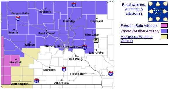
Nuisance to Plowable Snowfall. No Boston-style snows anytime soon. Beggars can’t be choosy. Much of the metro will pick up an inch or two today, maybe 3-4″ northern suburbs, the plowable potential increasing as you head north across the metro area. The south metro is not in the Winter Weather Advisory; details from the Twin Cities National Weather Service:
A POTENT...BUT FAST WINTER STORM WILL SPREAD A BAND OF SNOW ACROSS
THE ADVISORY AREA STARTING LATE TONIGHT IN WESTERN MINNESOTA...AND
MOVE EASTWARD ACROSS CENTRAL AND EAST CENTRAL MINNESOTA BY 9 AM.
THIS AREA OF SNOW WILL MOVE INTO WEST CENTRAL WISCONSIN BY LATE
MORNING. THIS SYSTEM WILL QUICKLY DEPART THE AREA BY TUESDAY
EVENING AS IT MOVES OFF INTO THE GREAT LAKES REGION.

THE HEAVIEST SNOWFALL WILL OCCUR NORTH OF ST. CLOUD MINNESOTA TO
CHIPPEWA FALLS WISCONSIN WHERE LOCALLY 3 TO 5 INCHES WILL
FALL. ELSEWHERE IN THE ADVISORY AREA...A QUICK ONE TO THREE
INCHES OF SNOWFALL WILL OCCUR BEFORE IT TAPERS OFF. SOME SLEET AND
FREEZING RAIN IS ALSO POSSIBLE DURING THE ONSET ACROSS PORTIONS OF
WEST CENTRAL MINNESOTA TUESDAY MORNING.
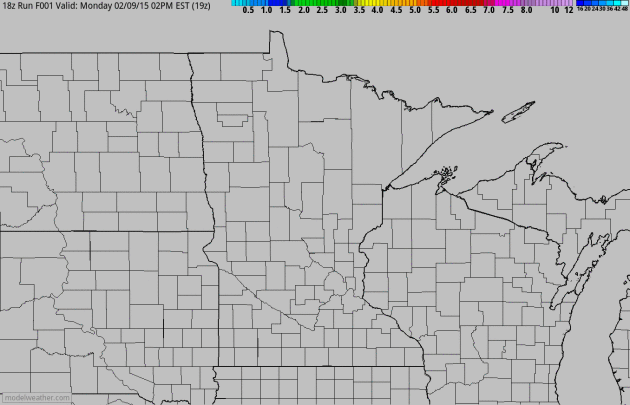
Fast-Moving Clipper. A couple of inches may fall midday into the afternoon hours, but with temperatures in the upper 20s MnDOT chemicals should do a better job keeping freeways more wet and slushy than snow-covered with this system. It may still be a slow PM commute, but I don’t expect a rerun of last week’s nightmare when 1.4″ snow fell at ground temperatures in the low teens shortly before evening rush hour. That sure was fun. 60-hour accumulated snowfall: NOAA NAM model and Aeris Weather.
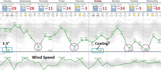
Cold Bias. I count 4 nights below zero, starting Wednesday night, again Friday night and next Monday and Tuesday night for good measure. Again, a pale imitation of last winter’s polar pain, but still cold enough to get your attention. After today’s clipper the next chance of a little snow comes Sunday. A cosmetic snowfall, not a Boston-snow. Graph: Weatherspark.
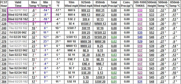
Bottoming Out Middle of Next Week? Various models are converging on the middle of next week for the coldest air temperatures, possibly dipping to -10F in the metro, but only lasting 1 or 2 nights. Some recovery is likely as we sail into the last week of February, but nothing springy is brewing just yet, based on GFS guidance from NOAA.

Slow Late-Month Moderation. The core of the coldest air shifts into Hudson Bay, eastern Canada and northern New England the last week of February with more of a modified-Pacific airflow reaching Minnesota. This would favor temperatures at or slightly below average with more clippers – no chance of southern moisture reaching us with 500 mb winds screaming from the northwest. Source: GrADS:COLA/IGES.
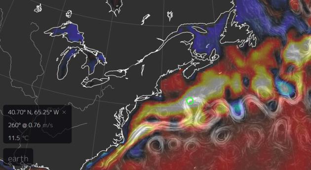
Warmer Air And Water Juicing Snowstorms in New England? Since 1958 there has been a 71% increase in the most extreme precipitation events (rain and snow) across New England. Warmer air holds more water vapor, increasing the potential for record amounts of precipitation. Here’s an excerpt of a post from Climate Nexus: “As you prepare to report on what is now the fifth in a series of snowstorms affecting southern New England, please consider some of the following information on the costs of extreme snow events and how climate change is linked to extreme events of this nature. Having received 61 inches so far this winter, Boston has already broken it’s 30-day snowfall record, and is now preparing for another two feet this week. Governor Baker said that enough snow has been plowed to fill the Patriot’s stadium 90 times. Snowstorms are an expected feature of winter weather in the Northeast, but the recent spate of storms in the region exhibits the fingerprints of climate change in several distinct ways.Above average sea surface temperatures add energy to the system, creating a stronger contrast with the cold front. That temperature gradient powers the storm, so a stronger gradient means a stronger storm. Also, warmer air holds more moisture, resulting in more precipitation...”
* graphic above courtesy of earth.nullschool.net shows Gulf Stream water temperature anomalies 11.5C warmer than average, roughly 14-15F warmer than average for early February.
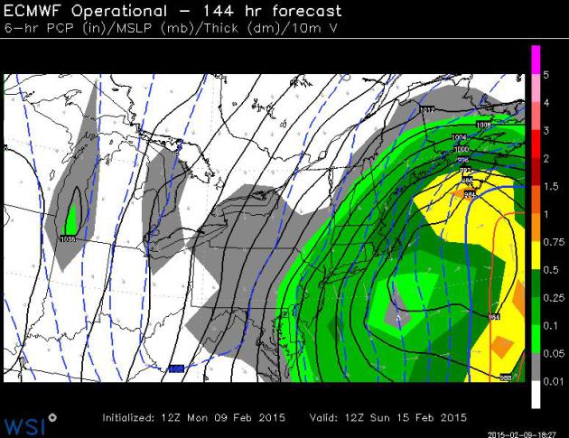
But Wait, There’s More! One of pet peeves watching reporters doing weather stories. Invariably they’ll scream into the microphone “…and meteorologists say another storm is ON THE WAY!” Uh huh. That’s a pretty safe forecast. It’s the where, when and how much that’s problematic. But in the case of Boston, it may be true. ECMWF guidance brushes coastal New England with blizzard conditions this weekend as polar air invades. Yes, it actually can get worse. Map: WSI Corporation.
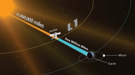
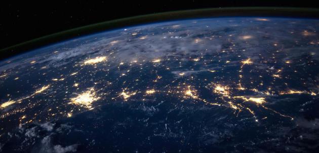
DSCOVR Satellite To Keep A Weather Eye On Solar Storms. It’s primary mission is to provide additional early warning for potentially dangerous solar flares capable of bringing down the power grid. But cameras will also be trained on Earth, to provide (delayed) imagery of our planet from space. Here’s an excerpt from Gizmag: “…DSCOVR, formerly known as Triana, is a first step toward remedying this. It began in the late 1990s as an Earth observation satellite. Though DSCOVR was built, it ended up in storage when the mission was canceled in 2001. There it remained until NOAA and the US Air Force took it out of mothballs in 2008. It was then refurbished by NASA and equipped with updated instruments, while the Air Force offered to foot the bill for a SpaceX Falcon 9 launch vehicle to put it into space on a five-year mission to provide warnings of incoming solar flares approaching the Earth…”
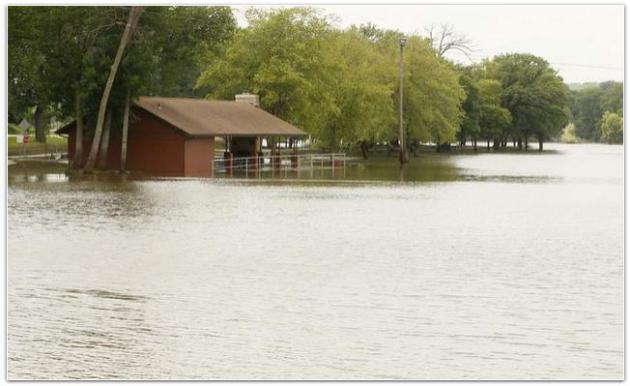
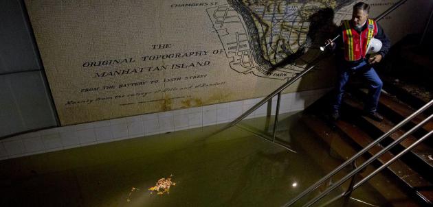
University of Iowa Study: Floods Not Markedly Bigger, But They Are Getting More Frequent. The Gazette in Cedar Rapids has a very interesting story – here’s a link: “…The central United States — including Iowa — has seen more flood events in recent years, although the magnitude of those events has not increased, according to a new study out of the University of Iowa. Changes in both seasonal rainfall and temperature across the Midwest appear to be driving the rise in flood frequency, causing “adverse societal consequences” — like decreased food production, displaced communities and residents, and other economic losses reaching the billions…”
Photo credit: “Manhattan Park in Cedar Rapids is inundated by floodwaters from the Cedar River on Sunday, July 6, 2014.” (Cliff Jette/The Gazette-KCRG TV9)
Mystery Of The “Milky Rain” In Eastern Washington Solved? It would appear it’s Nevada’s fault. KOMO News has an interesting article about a meteorological mystery; here’s an excerpt: “...Strange things were afoot in eastern Washington and parts of eastern Oregon and the Idaho panhandle Friday when the day’s rain showers left a bit of a milky residue on cars and whatnot.…”
Photo credit: “Photo of a dirty, milky substance that has fallen on cars outside the National Weather Service office in Spokane, Wash. on Feb. 6, 2015.” Photo courtesy: National Weather Service, which has a good explanation of how a white rain may have formed.


Send In The Weathermen. The meteorological equivalent of Navy Seals or Delta Force? I had no idea. Check out the article from NBC News; here’s a clip: “…He was a weatherman. More precisely, he was a special operations weather technician, known as a SOWT (pronounced sow-tee). As the Department of Defense’s only commando forecasters, SOWTs gather mission-impossible environmental data from some of the most hostile places on Earth. They embed with Navy SEALs, Delta Force and Army Rangers. Ahead of major operations they also head in first for a go/no-go forecast. America’s parachutes don’t pop until a SOWT gives the all-clear…”
How Warming May Alter Critical “Atmospheric Rivers”. Climate Central has a summary of new research focused on these firehoses of moisture that can turn drought into flood in the meteorological blink of an eye; here’s a clip: “…The hose has been turned back on full-force over Northern California: A stream of moisture is flowing over the drought-riddled state and dropping copious amounts of rain just days after the close of one of the driest Januaries on record. The influx of much-needed rain comes courtesy of a feature called an atmospheric river that is a key source of much of the state’s precipitation and water supply. A relatively recent meteorological discovery, these ribbons of water vapor in the sky are something scientists are trying to better understand. They are flying research planes into the heart of the current storm to study what fuels it, which could help improve forecasts of the events…”
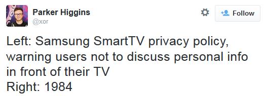
Your Samsung SmartTV Is Spying On You, Basically. Add this to a long and growing list of things to be paranoid about. Be careful what you say in front of that big screen television set. Here’s an excerpt from The Daily Beast: “You may be loving your new Internet-connected television and its convenient voice-command feature—but did you know it’s recording everything you say and sending it to a third party? Careful what you say around your TV. It may be listening. And blabbing. A single sentence buried in a dense “privacy policy” for Samsung’s Internet-connected SmartTV advises users that its nifty voice command feature might capture more than just your request to play the latest episode of Downton Abbey…”
* Yes, this does bear a striking similarity to some of the plot lines in George Orwell’s 1984. God help us when the machines take over.

How YouTube Changed The World. The Telegraph explains why many legacy media networks remain paranoid about YouTube, and for good reason. Here’s a clip: “…In the eight years since, YouTube has become a raucous town square for those who aspire to power, good and evil. Isil and KKK propaganda videos jostle for attention alongside English town council candidates and teenage pranksters. The veteran Middle East reporter, Jeffrey Goldberg, recently wrote that extremists no longer bother meeting with journalists. “They don’t need a middleman anymore. Journalists have been replaced by YouTube…”

The Life, Death, And Rebirth Of BlackBerry’s Hometown. Fusion has the story; here’s a snippet: “…BlackBerry is still alive – it has 7,000 employees worldwide, trades at a market value of $5.25 billion, and turned a small profit last quarter – but most people here speak about it in the past tense. The company’s market value has fallen more than 90 percent from its peak, and it has less than a one percent share of the global smartphone market, having been reduced to rubble by Apple, Samsung, and other manufacturers years ago. President Obama still has his BlackBerry, but most other people ditched theirs a while back...” (Image credit: Gabriella Peñuela).

High-Tech Hotel in Japan Will Be Staffed By Multilingual Robots. It’s a slippery slope, automation, robotics and computers replacing things done by carbon-based lifeforms. Check out this story from The Verge; here’s an excerpt: “…This summer, a hotel will open in the Netherlands-themed Huis Ten Bosch amusement park in Nagasaki, Japan. It will have 72 rooms. Room fees will start at $60 per night. And it will be staffed by 10 humanoid robots. The Henn-na Hotel’s blinking and “breathing” actroids will be able to make eye contact, respond to body language, and speak fluent Chinese, Japanese, Korean, and English, The Washington Post reports. They will check in guests, carry bags, make coffee, clean rooms, and deliver laundry…”

TODAY: Dry start. Snow develops. 1-3″ by evening, only a coating far south metro. Winds: SE 15. High: near 30
TUESDAY NIGHT: Slick roads as snow tapers to flurries. Low: 20
WEDNESDAY: Windy, tumbling temps. Winds: NW 15-30+ High: 22
THURSDAY: Blue sky, light winds. Wake-up: -4. High: 13
FRIDAY: Mostly cloudy, colder surge late. Wake-up: 5. High: 22
SATURDAY: Hello January! Wind chill: -20. Wake-up: -2. High: 6
SUNDAY: Next clipper. Light accumulation? Wake-up: -3. High: 17
MONDAY: Gray, snow may stay south. Wake-up: 6. High: 25
Climate Stories…
State Looks At Health Impact of Climate Change. Here’s the introduction to a story at The Star Tribune: “Minnesotans will suffer from more asthma, respiratory problems, cardiovascular disease and such bug-borne diseases as West Nile virus and Lyme disease as climate change takes hold across the Upper Midwest, according to a new report from the Minnesota Health Department. It’s the latest in a series of “vulnerability assessments” that Gov. Mark Dayton ordered from his Cabinet to prepare Minnesota for the inevitable…” (Image: NASA).
White House: Climate Change Threatens National Security. The Hill has the story; here’s an excerpt: “…The present day effects of climate change are being felt from the Arctic to the Midwest. Increased sea levels and storm surges threaten coastal regions, infrastructure, and property. In turn, the global economy suffers, compounding the growing costs of preparing and restoring infrastructure.” The administration argues that effective action against climate change will bolster the security of the United States and its allies…”
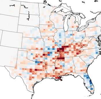
Will Global Warming Bring More Tornadoes? Here’s an excerpt of a story from LiveScience and The Christian Science Monitor: “…Researchers examined how global warming will affect severe weather during the heart of tornado season — March, April and May. They found that while the yearly tornado total will climb by 2080, the number of tornadoes will also vary wildly from year to year. That’s because sometimes, the weather will get stuck in a pattern that favors tornadoes, and sometimes, conditions will stymie stormy weather, according to the report, published Jan. 15 in the journal Climatic Change…”
Graphic credit above: “Average differences between severe weather in 1980-1990 and 2080-2090. Red means more severe storms, and blue means fewer storms.” Victor Gensin.
Talking Like Grown-Ups About Climate Change. If you could pay a few dollars a month to lower the risk of (catastrophic) climate change down the road would you consider it? Here’s an excerpt of an Op-Ed at Bloomberg View: “...If the second answer is the right one, then there may be an opening for an adult conversation about the topic. If we are worried about climate change, surely we would be willing to pay something — at least if it isn’t a lot — to reduce the risk. According to some estimates, the U.S. could do a lot to reduce greenhouse gases if the average American paid a monthly energy tax, targeted to such emissions, of $10, along with an equivalent gasoline tax…” (Stock image above: PBS).

Climate Change, Weather Variability Challenge Yukon Quest Mushers. Where’s the snow? An anthem being heard from Minnesota to Alaska, it seems. Alaska Public Media has the story; here’s the intro: “The Yukon Quest International Sled Dog race starts Saturday. For more than 30 years, the race course has followed an old Gold Rush era trail that took advantage of the frozen Yukon River. But recently, there have been places where the river hasn’t frozen up. That’s starting to raise question about the impacts of climate change on Alaska’s state sport…”

Major Snowstorms In British Columbia Prompt Climate-Change Worries. In at least one case freak midwinter rains have forced one ski resort to close altogether. Here’s an excerpt from The Globe and Mail: “Warm weather and rain linked to the Pineapple Express weather system is forcing Mount Washington Alpine Resort on Vancouver Island to shut down its winter operations as of Monday, a rare situation that comes as industry operators fear the impact of climate change…”
Quantifying The Impact of Climate Change on Extreme Heat in Australia. The Climate Council has a full report; here’s an excerpt of a summary: “…Climate change is making Australia hotter. Hot days are happening more often while heatwaves are becoming hotter, longer and more frequent.
- The annual number of record hot days across Australia has doubled since 1960. Over the past 10 years the number of record hot days has occurred three times more frequently than the number of record cold days.
- The annual occurrence of very hot days across Australia has increased strongly since 1950 and particularly sharply in the last 20 years…”
Read Paul’s New Book
Caring for Creation: The Evangelical’s Guide to Climate Change and a Healthy Environment