The Weather Blog
Daily weather updates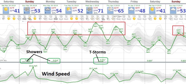
Warming Trend – Spring Returns Next Week
36 F. high temperature in the Twin Cities Friday.
47 F. average high on March 27.
40 F. high on March 27, 2014.
March 28, 1924: A drought was broken in Southern Minnesota with style as 25 inches of snow fell.
Warming Trend
“People don’t notice whether it’s winter or summer when they’re happy” wrote Anton Chekhov. Apparently Anton never hung out in Minnesota, where, when we discuss the day’s weather, we often smile through gritted teeth. Late March in Minnesota is boom-bust, all or nothing, the beauty and the beast. Anything goes.
Exhibit A, tomorrow’s date in 1924: eleven inches of snow swamped the Twin Cities. In 1969 the mercury sank to -5F. But 1986 brought a hot front with a record 83 degrees. All on the same date in late March. Throw in river flooding and occasional March tornadoes and now you know why meteorologists are cross-eyed this time of year.
Nothing quite that extreme is brewing anytime soon, I’m happy to report. The greater the swing in temperature the faster the wind has to blow to keep the atmosphere in an uneasy state of equilibrium. Translation: windy today as temperatures recover from a chilling rerun of February. 50s return Sunday; a few are 60s likely next week – punctuated by a midweek rumble of thunder. Cooler weather returns late next week – keep a jacket handy.
With most of Minnesota in moderate drought there will be no whining about rainy days.
Let it rain. Please.
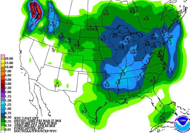
Showery – But No Soaking Rain Events. I keep waiting for a big, sloppy southern storm to push north across the Great Plains, supercharged with moisture from the Gulf of Mexico. We’ll have to wait a bit longer; a few waves of (light) showers into next week, with heaviest rainfall amounts middle Mississippi Valley and Pacific Northwest. Map: NOAA.
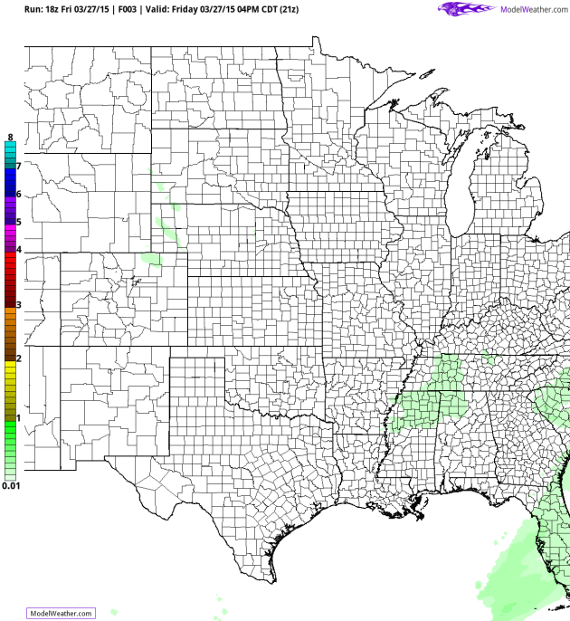
Sunday Showers. NAM guidance from NOAA shows a fast-moving frontal boundary pushing (rain) showers across Minnesota and the Upper Midwest Sunday morning. The map above shows predicted 60-hour accumulated precipitation amounts. Animation: Ham Weather.
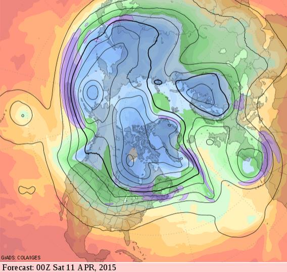
Moderate Extended Outlook. 500 mb forecast winds (GFS) valid the evening of April 10 show a zonal flow, one likely to create temperatures close to average for the second week of April, a relatively dry zonal flow that doesn’t favor significant moisture reaching Minnesota. Source: GrADS:COLA/IGES.

Warmer Bias Returns in March. Dr. Mark Seeley provides perspective on a statewide basis; here’s an excerpt of WeatherTalk: “…It appears that March will wrap up bringing higher temperatures and more moisture the last few days of the month. Most observers will report a mean monthly temperature from 4 to 7 degrees F warmer than normal (mean values), and total precipitation that is less than normal. Extremes for the month were 78F at Browns Valley on the 15th and -40F at Cotton on the 5th, with the highest monthly precipitation value of close to 2 inches at Lanesboro…”
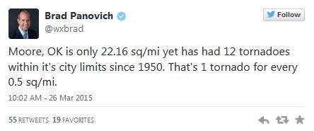
Moore, Oklahoma: Tornado Magnet. The Washington Post’s Capital Weather Gang has a good summary of Wednesday’s tornado outbreak, and speculates on why the southern suburbs of Oklahoma City have been struck so often in recent years: “…Other than the fact it lies in the heart of tornado alley, there is no clear reason why Moore keeps getting hit by tornadoes. Studies have shown urban environments can sometimes enhance rain from thunderstorms downwind of cities (and Moore is just south of Oklahoma City), but little work has been done to determine if cities impact tornado formation...”

AccuWeather Rips National Weather Service For “Late Tornado Warning”. I had no idea AccuWeather was issuing their own warnings. You can read their write-up about the recent Moore EF-1 tornado and how they approached the storm here.
Advanced Warnings Questioned After Tornado. More complaints from Moore residents highlighted in the Norman Transcript.
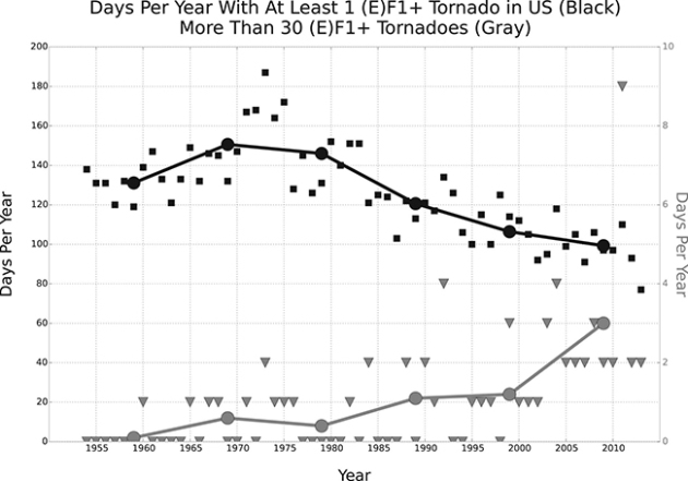
Tornado Seasons Like The Ones You’re Used To Could Be Changing, New Studies Find. Here’s the intro to a story at weather.com: “When eliminating (E)F0 tornadoes from yearly counts, which have steadily risen over the past few decades due to more extensive spotter networks, the implementation of Doppler radar, and advanced technology such as smartphones and social media, there is essentially no long-term yearly trend in the raw number of (E)F1 and stronger tornadoes. However, the number of days with at least one (E)F1+ tornado in the U.S. has fallen from an average of 150 such days in the early 1970s to around 100 days in the first decade of the 21st century, according to an October 2014 study in the journal Science...”
Graph credit above: “EF-1 Tornado Days and Active Tornado Says. Number of days each year with at least one (E)F1 tornado (black squares) and more than 30 (E)F1 tornadoes (gray triangles) from 1954-2013. Average over each decade indicated by large dots and line plots.” (Brooks et al. 2014).

Let’s Give Them Something To Tweet About – – Why Periscope Matters. Dave Pell at NextDraft takes a look at how the addition of live video streaming with Periscope in Twitter may turbocharge self-publishing. All those cat videos. Here’s an excerpt: “…That’s where Periscope comes in. Except in rare cases, these streamed events will not be global or even national in nature. But they will be live, we’ll know exactly who’s watching with us, and the content will be pushed through the same pipes that support our conversations around it. Live fodder for discussion and the discussion itself all on the same social network. To paraphrase the great Bonnie Raitt, Twitter had to give us something to Tweet about…”

Periscope Turns Any iPhone User Into A Live Broadcaster. Gizmag takes a look at the new app as we all distract ourselves to death: “…You can sign in using your Twitter account and start to follow people, at which point their live streams will start to appear in a feed. A simple tap means you can see the world through the eye of your new friend’s smartphone camera for as long as they choose to keep the stream running. At the same time, you can leave comments or tap the screen once to send the user a Instagram-like heart to show your appreciation…”
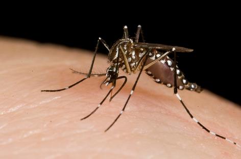
When It Comes To Nature’s Public Enemy Number One, The Mosquito Is A Modern Monster. You’re preaching to the choir – here’s a clip from The Australian: “They are the answer to the classic quiz question: “What is the most deadly animal on earth?” By the time contestants have debated the demerits of tigers, cobras and great white sharks scores of victims of the real worst killer will have died and other people will have been infected by the diseases it spreads. The mosquito goes about its deadly business every day, moving infections around that kill hundreds of thousands of humans every year..”
Photo credit above: “Exotic mosquitoes like this ‘Asian tiger’ are heading to the UK.” Australian government, CC BY
TODAY: Partly sunny, stiff breeze. Winds: S 10-20. High: 46
SATURDAY NIGHT: Increasing clouds, not as cold. Low: 36
SUNDAY: Gray, showers likely. High: 53
MONDAY: Some sun, stray late PM shower. Wake-up: 37. High: 58
TUESDAY: Plenty of sun, very pleasant. Wake-up: 40. High: 61
WEDNESDAY: Unsettled with showers, thunder? Wake-up: 48. High: near 60
THURSDAY: Drier day, cooling off a bit. Wake-up: 42. High: 53
FRIDAY: Chance of showers, mix up north. Wake-up: 37. High: 43
Climate Stories…

Keeping Global Warming at 2C Rise May Not Be Enough, Says Climate Expert. Tech Times has the story; here’s a clip: “…Experts claim that the 2°C limit may still lead to shifts in rainfall patterns, the increase in sea levels and extreme natural events, such as heat waves, floods and droughts, especially in the tropics, high mountain areas and even the polar regions. Petra Tschakert, lead author of the IPCC Fifth Assessment Report, believes that the 2°C target may pose a threat to livelihoods and ecosystems…”
Photo credit above: “Maintaining a target of a 2°C temperature rise for the entire planet may still lead to the devastating effects of global warming, a leading climate scientist warns.” Photo: USGS.

Meet The Cool Beans Designed To Beat Climate Change. NPR has a story of innovation and adaption; here’s a clip: “A planet that is warming at extraordinary speed may require extraordinary new food crops. The latest great agricultural hope is beans that can thrive in temperatures that cripple most conventional beans. They’re now growing in test plots of the International Center for Tropical Agriculture, or CIAT, in Colombia. Many of these “heat-beater” beans resulted from a unique marriage, 20 years ago, of tradition and technology. The matchmaker was a Colombian scientist named Alvaro Mejia-Jimenez. But for almost two decades, his innovation sat on the shelf, unused…”
Photo credit above: “Steve Beebe, leader of CIAT’s Bean Program, in a field of experimental bush beans at CIAT’s headquarters in Colombia.” Courtesy of CIAT/Neil Palmer.
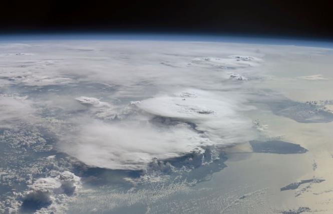
Tropics Getting Warmer: Sign of Warming Times? Discovery News has the research, which mirrors what we’re seeing in northern latitudes: fewer storms during the warm months, but the storms that do form tend to be larger with more intense rainfall: “…Tan’s group, along with NASA, published the study. Thunderstorms play a key role in tropical weather. Thought they occur just 5 percent of the time, researchers said, they account for about half of the rainfall in the tropics. “What we are seeing is more big and organized storms and fewer small and disorganized storms,” Tan said…”
Image credit above: “Large thunderstoms in the tropics are becoming more common — and small storms less so — increasing total rainfall.” Earth Science and Remote Sensing Unit, NASA Johnson Space Center.

Ted Cruz Compares Climate Change Activists to “Flat Earthers”. Where To Begin? Here’s an excerpt from an Op-Ed at The Washington Post: “…First, Cruz conflates the science of climate change with the politics of climate change. Scientists don’t scream, “You’re a denier.” They point to the scientific evidence that human activity is leading to climate warming — the evidence of which is overwhelming. (Here’s the international version and the U.S. version.) There is no “evidence that disproves their apocalyptical claims,” because if there were, scientists would abandon the theory. That’s how science works…”
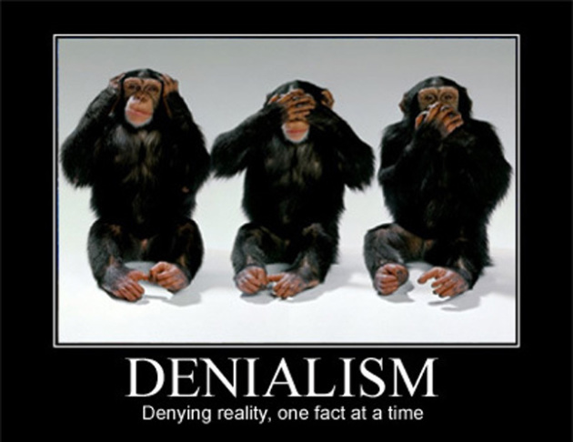
How Should Journalists Treat Candidates Who Deny Climate Change? Here’s an excerpt from The Los Angeles Times: “…Climate change denial, at its core, is an economic position, not scientific. Reporters who take a basic “follow the money” approach soon discover that their path leads them to fossil fuel interests. The oil and gas industry was the second-largest source of campaign donations to Cruz, at $1.1 million in 2011-14, according to the Center for Responsive Politics. It’s the leading donor to Sen. James Inhofe (R-Okla.), the Senate’s top climate change denier, making $576,000 in contributions since 2009. (The second-largest donor: the utility industry, at $278,000.)...”
How American Journalists Deal With Climate Deniers. Grist has the story.
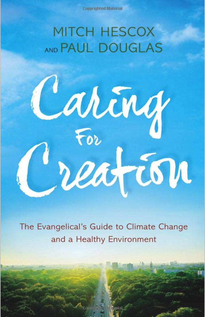
Read Paul’s New Book
Caring for Creation: The Evangelical’s Guide to Climate Change and a Healthy Environment