The Weather Blog
Daily weather updates
Warming Trend – Thursday Soaker Potential – Trending Wetter With Time
83 F. high in the Twin Cities Sunday.
Trending Wetter
Springs are trending wetter in Minnesota. According to Dr. Mark Seeley, author of the information-rich “Minnesota Weather Almanac”, May will probably be one of the 15 wettest on record, statewide. It was also the 5th May in a row of wetter than average conditions.
Remember June 2014? It was the wettest month, statewide, ever observed. Lakes were overflowing; something I thought I’d never see.
So California and much of the west is trending drier; intense droughts becoming more persistent. While flooding and extreme precipitation events have spiked from Minnesota to Maine since the 50s. Coincidence? Perhaps. Then again it may have something to do with the 40 percent spike in CO2, rapid arctic warming and a jet stream that doesn’t look anything like I remember growing up.
The ECMWF (European) model prints out 3.4 inches of additional rain by next Wednesday, most of that coming Thursday, as a slow-moving storm tracks along a stalled front. Models are hinting at some clearing next weekend. And if you miss the heat you may be in luck! We clip 80 degrees today; the mercury kissing 90F on Tuesday before cooling off by late week.
No broiling heat waves in sight yet. Just a taste.
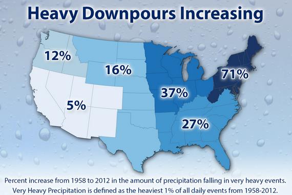
Harder Rains. The map above shows the most extreme rainfall trends from 1958-2012, courtesy of Climate Central.

Sunday Rainfall Streaks. Instability showers and T-storms sprouted during the afternoon hours, with the heaviest rains near Mora and Princeton, more heavy rain for far southern Minnesota. Most of the metro salvaged a fine Sunday with a few pop-up showres over the south metro. 60 mph wind gusts were reported at Pine River, near Brainerd with Sunday’s T-storms.
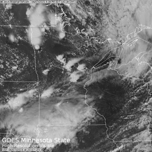
Garden-Variety Thunderstorms. The wind profile aloft wasn’t ripe for supercell thunderstorms yesterday, but the lapse rate (the rate of cooling) was steeper than usual, meaning cooling off faster than usual. Rising thermals during the afternoon sprouted into thunderstorms, a few producing downpours and .5″ diameter hail. Visible satellite loop: WeatherTap.

Textbook Example of a Gust Front. Last night’s thunderstorms produced intense downdrafts of rain and hail-cooled air, creating a miniature cool front out ahead of the strong storms, called a “gust front”. NWS Doppler radar at 10:38 PM.
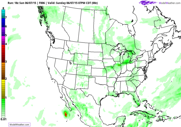
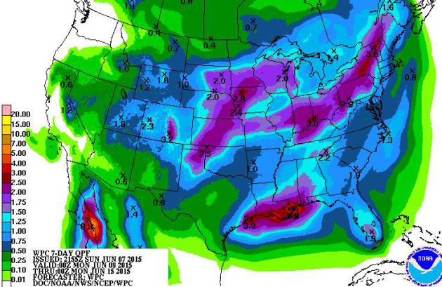
A Very Wet Pattern. GFS guidance shows some 2-4″ rains over the next 7 days from the Central Plains into the UPper Midwest, Great Lakes and Ohio Valley. The odds of a summer drought east of the Rockies are dropping with each passing week. NOAA model: AerisWeather.
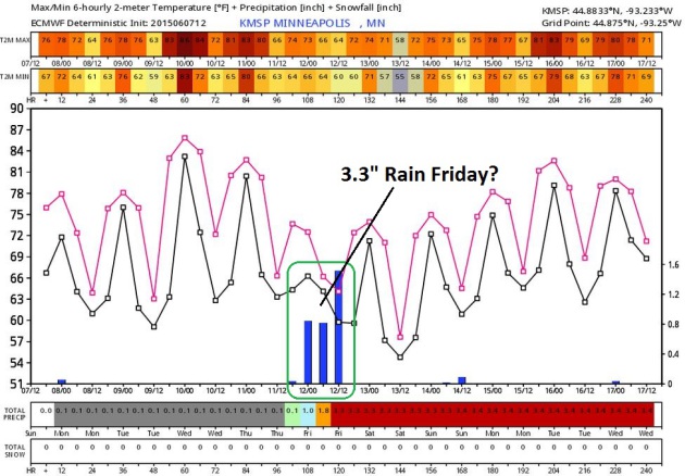
ECMWF Guidance. The European model shows a 3″+ deluge on Friday – not convinced we’ll see that much, but a slow-moving storm tracking along a temporarily stalled east-west frontal boundary may result in locally heavy rain, even some flash flooding close to home. MSP Meteogram: WeatherBell.
Watering Optional. I’m not convinced we’re going to see 3 or 4″ of rain over the next week, but an inch or two of rain is quite possible Thursday into Friday morning, especially over southern Minnesota.
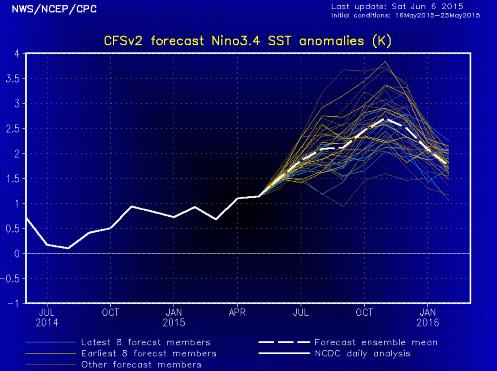
Biggest El Nino Since 1998? Every new NOAA prediction seems to increase the predicted intensity of the warming of Pacific Ocean water for later in 2015. El Nino correlates with warmer weather for most of the USA, and a lesser risk of hurricane formation in the Carribean and Atlantic due to stronger subtropical winds aloft. Odds would also favor a longer, warmer autumn. Would I bet the farm on that? Nope.


TODAY: Warm sunshine, very nice. Winds: NW 10-15. High: 81
MONDAY NIGHT: Clear and mild. Low; 64
TUESDAY: Hot sun, stray T-storm late. Dew point: 61. High: 89
WEDNESDAY: Sunny, a little less humid. Dew point: 56. Wake-up: 63. High: 83
THURSDAY: Showers, T-storms. Heavy rain likely. Wake-up: 62. High: 75
FRIDAY: Wet start, then clearing skies. Wake-up: 59. High: 78
SATURDAY: Looking better. Partly sunny skies. Wake-up: 63. High: 82
SUNDAY: Sticky again, few T-showers. Dew point: 63. Wake-up: 65. High: 83
Climate Stories…
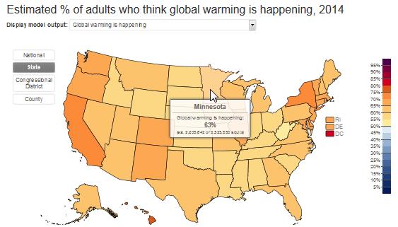
What Your Neighbors Think About Climate Change. 63% of Minnesota adults acknowledge that it’s warming up – the same percentage as adults in Texas. Here’s an excerpt from Huffington Post: “…A research team at Yale and Utah State Universities combined seven years of survey data, including more than 13,000 individual respondents, to develop a statistical model. The model accurately estimates American public climate change beliefs, risk perceptions, and policy support in all 50 states, 435 Congressional districts, and 3,000+ counties. A description of the model and how it works can be found in the recently published paper in Nature Climate Change ...”
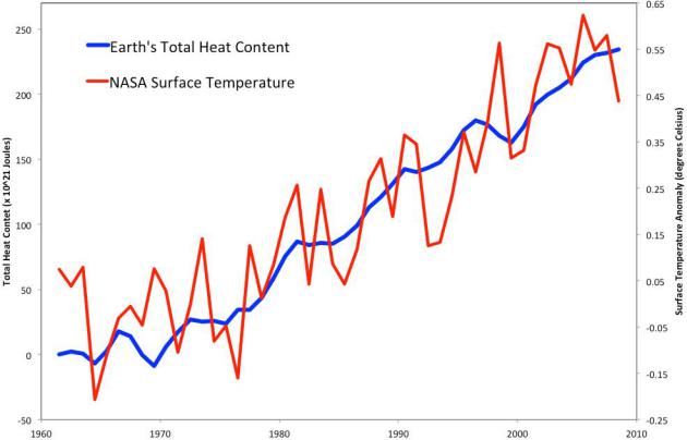
Forget About The “Hiatus” – Warming Of The Earth Has Continued. Much of that extra warmth has gone into the oceans in recent years, according to a story at Climate News Network and truthdig.org. Here’s an excerpt: “Forget about the so-called “hiatus” in global warming. The planet’s average temperatures are notching up as swiftly now as they did 20 or 30 years ago. A team of US researchers has looked again not just at the data for the last 60 years but at how it has been collected, and done the sums again. They conclude, in the journal Science, that the “estimate for the rate of warming during the first 15 years of the 21st century is at least as great as the last half of the 20th century. These results do not support the notion of a ‘slowdown’ in the increase of global surface temperature rise...”
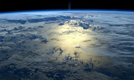
Shell’s Former Chairman Made a Startling Comment About Climate Change. TIME Magazine has the story; here’s the intro: “When the oilmen themselves are arguing for stronger action to fight climate change, it’s probably time to start acting. Sir Mark Moody-Stuart, the former chairman of oil giant Royal Dutch Shell, said that the lack of progress the world has made on climate change is, “distressing,” and that it was “rational” for investors to start divesting their money from companies that extract fossil fuels, according to a report in The Guardian...” (Image: NASA’s International Space Station).
Read Paul’s New Book
Caring for Creation: The Evangelical’s Guide to Climate Change and a Healthy Environment