The Weather Blog
Daily weather updates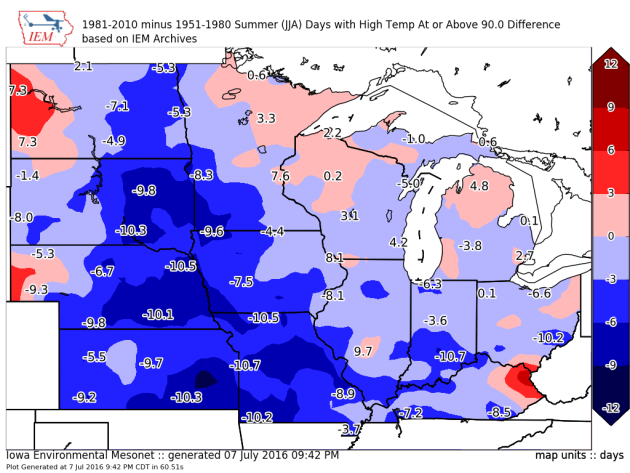
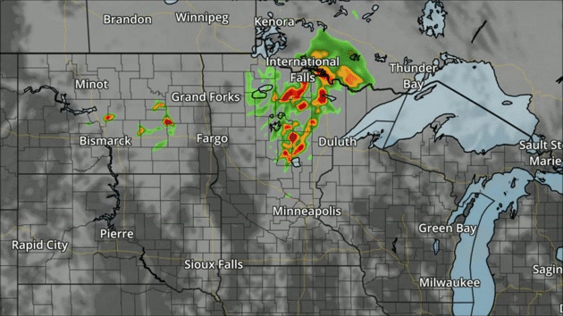
Strong Storms Possible Both Sunday And Monday
Change In 90+ Degree Days Across The Upper Midwest
Here’s an interesting map that the Iowa Environment Mesonet (IEM) posted on Friday, showing the change in average 90 degree days summer (June-August) between the 1951-1980 and 1981-2010 climatological averages. While we can see the number of 90 degree days has gone up across parts of northern Minnesota and into the Twin Cities, the number has actually decreased over parts of western and southern Minnesota. Why is this? Here’s what IEM had to say: “Much of the map shows negative values meaning a decrease in the number of days. A good portion of this negative area resides in the western progression of the corn and soybean belt. The thought is that the intensified agriculture modulates summer time temperatures.”
_______________________________________________
MONDAY: Stinking hot, feels like 100F. High 92. Low 72. Chance of precipitation 40%. Wind S 10-20 mph.
TUESDAY: Warm sun, slightly less humid. High 88. Low 68. Chance of precipitation 20%. Wind SW 10-15 mph.
WEDNESDAY: Intervals of sun, more comfortable. High 83. Low 63. Chance of precipitation 20%. Wind NW 10-15 mph.
THURSDAY: Plenty of sunshine, pleasant. High 81. Low 64. Chance of precipitation 10%. Wind NW 7-12 mph.
FRIDAY: Some sun, isolated T-storm. High 85. Low 66. Chance of precipitation 40%. Wind S 7-12 mph.
SATURDAY: Sticky sun, passing T-shower. High 87. Low 74. Chance of precipitation 40%. Winds S 10-15 mph.
_______________________________________________
This Day in Weather History
July 10th
_______________________________________________
Average Temperatures & Precipitation for Minneapolis
July 10th
Average High: 84F (Record: 106F set in 1936)
Average Low: 64F (Record: 49F set in 1996)
Average Precipitation: 0.13″ (Record: 1.93″ set in 2002)
________________________________________________
Sunrise/Sunset Times for Minneapolis
July 10th
Sunrise: 5:37 AM
Sunset: 9:00 PM
*Length Of Day: 15 hours, 22 minutes and 44 seconds
*Daylight Lost Since Yesterday: ~1 mins & 20 secs
*Next Sunrise That Is Before 6 AM: August 3rd (6:01 AM)
*Next Sunset That Is Before 9 PM: July 11th (8:59 PM)
Sunday And Beyond Minnesota Weather Outlook
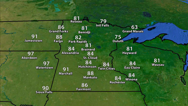
We’ll see warmer temperatures as we head into Sunday, with highs climbing into the mid 80s in the Twin Cities. 90s will be possible across parts of southwest Minnesota, and temperatures could near 100 in parts of northeast South Dakota including Aberdeen and Watertown.
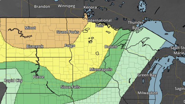
Severe risk Sunday. Dark green – marginal threat. Yellow – slight threat. Orange – enhanced threat.
The region is under a risk of severe weather Sunday, with large hail and damaging winds possible. As we head into the evening and overnight hours, there is an Enhanced Risk of severe weather across northwest Minnesota with a line of storms moving through. Damaging winds will be the main threat in this region, with hail and tornadoes back into North Dakota during Sunday afternoon/evening.
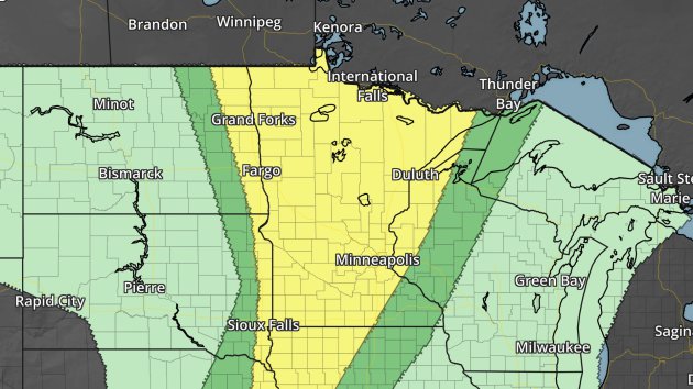
Severe risk Monday. Dark green – marginal threat. Yellow – slight threat.
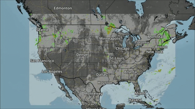
In addition to the storms over the Northern Plains, we’ll be watching for some showers and storms across the Northeast, Southeast and into the Northwest on Sunday.
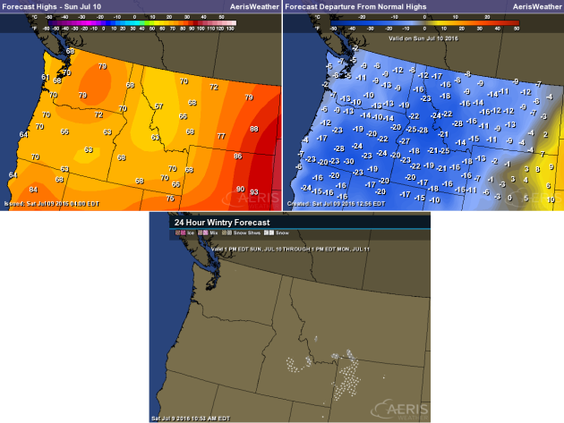
What is interesting in the Northwest will be the temperatures along with the precipitation, which will be a good 10-30 degrees below average for this time of year. There’s the potential that, in higher elevation areas across Idaho, Montana, and Wyoming, some snow may be possible Sunday Night.
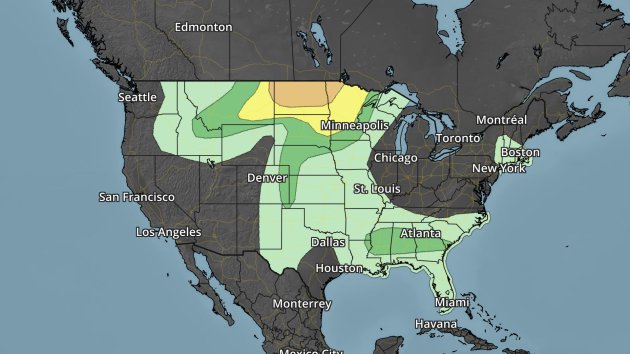
Severe risk Sunday. Dark green – marginal threat. Yellow – slight threat. Orange – enhanced threat.
Besides the hail, wind and tornado threat across the Northern Plains, hail and wind may be possible in parts of the Central Plains with any storms that go severe during the late afternoon and evening hours. Some storms capable of damaging winds will also be possible in the Southeast.
Excessive Rain To Begin July
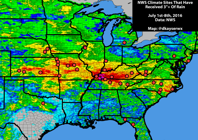
It’s been a very wet start to the month of July from the Central Plains to the Mid-Atlantic. Every red dot is an official NWS climate location that, over the first eight days of July, has already seen at least three inches of rain this month.
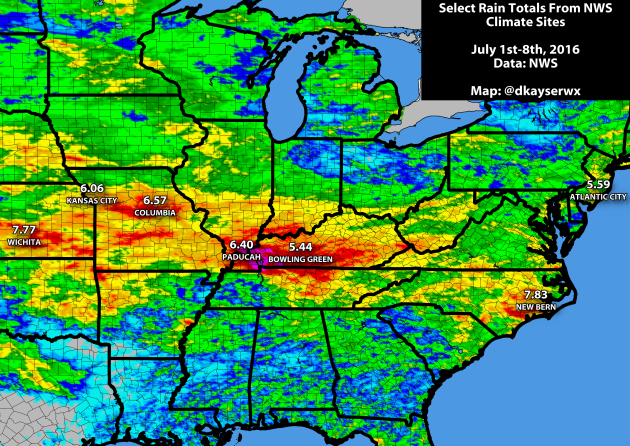
Here are rainfall totals so far this month for some of those select cities. All of these cities have seen over 5″ of rain so far this month – from Wichita, KS to Atlantic City, NJ – and some are quickly approaching the some of the wettest Julys on record. If the month were to have ended on Friday, here’s where these rainfall totals would rank in wettest Julys on record:
- Wichita, KS: 7th wettest
- Columbia, MO: 13th wettest
- Paducah, KY: 16th wettest
- New Bern, NC: 21st wettest
- Atlantic City, NJ: 24th wettest
- Kansas City, MO: 28th wettest
- Bowling Green, KY: 39th wettest
Fort McMurray Fire Costliest Canadian Natural Disaster On Record
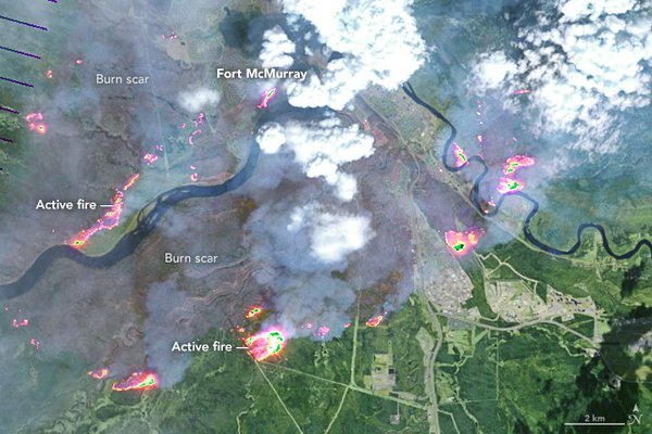
Satellite image of Fort McMurray fire back on May 4th. Image: NASA.The Insurance Bureau of Canada said on Thursday that the wildfire back in May in northern Alberta (in the Fort McMurray area) is now “the costliest insured natural disaster in Canadian history” with damage estimated at $3.58 billion. The previous Canadian costliest natural disaster was $1.7 billion from the 2013 southern Alberta floods. Climate Central has more: “The wildfire, which ignited May 1 in eastern Alberta and was brought under control on July 5, forced Canada’s largest-ever evacuation. It scorched more than 1.4 million acres and destroyed 2,400 homes and other buildings in and around Fort McMurray, the hub of Canada’s oil sands industry.”
Thanks for checking in and have a great Sunday! Don’t forget you can follow me on Twitter (@dkayserwx) or on Facebook (Meteorologist D.J. Kayser)!
–D.J. Kayser

Read Paul’s New Book
Caring for Creation: The Evangelical’s Guide to Climate Change and a Healthy Environment