The Weather Blog
Daily weather updates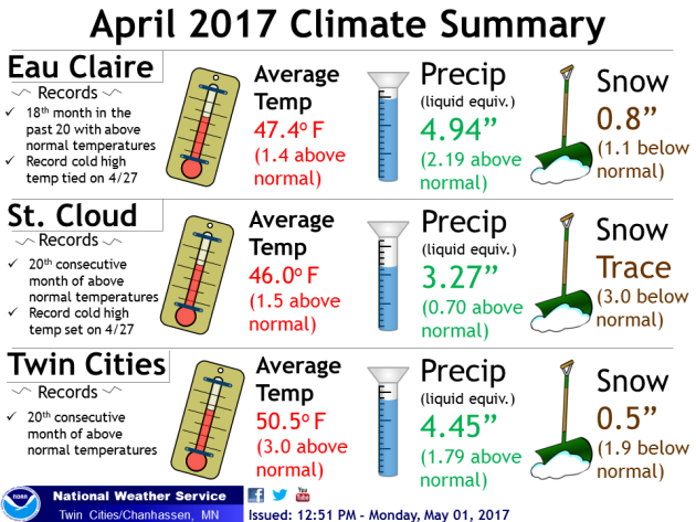
Shower Chance Wednesday, Then The Doldrums Of May
April Recap
April 2017 marked the 20th consecutive month with temperatures that were above average in both the Twin Cities and St. Cloud, streaks which stretch back to September 2015. Not only was it a warm month, but also a wet month across the region, with precipitation values that were above average. The Twin Cities ended up having their 12th wettest April on record. That above average precipitation didn’t come in the form of snow, though, with less than an inch falling in Eau Claire, St. Cloud and the Twin Cities.
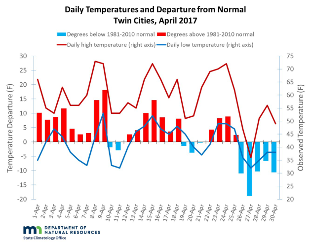
Only ten days during the month saw an below average average temperature in the Twin Cities, with half of those days occurring in the last few days of the month. The Minnesota Climatology Office has a look back at last month in the Twin Cities, as well as more on where this 20th consecutive month above average puts us in the record books.
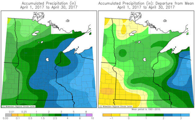
Taking a look at just precipitation last month, eastern Minnesota saw the most over the entire month, with a good 3″+ falling in many location. The areas that saw below average moisture last month were in northwestern and southwestern parts of the state.
Plant ’17 Minnesota Update
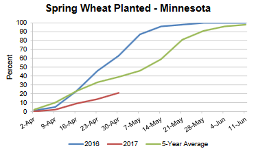
The weekly crop progress update came out Monday from the USDA, and it showed that last week was not well suited once again for farmers to get out into the fields. Only 1.7 days last week were suitable for field work due to the cooler temperatures and wet fields. This is taking a toll on planting, as only 21% of spring wheat and 12% of corn is planted. On average, 49% of wheat and 36% of corn has been planted by this time across the state. The numbers are also far behind last year, when 61% of wheat and 57% of corn had been planted by now. Hopefully drier and warmer weather later this week will help improve field conditions.
The University of Minnesota Extension office has more on what’s next for corn and soybeans farmers due to this recent weather. They say that farmers can expect maximum corn yield if they can get the crops in the ground by mid-May.
May 2013 Snowstorm
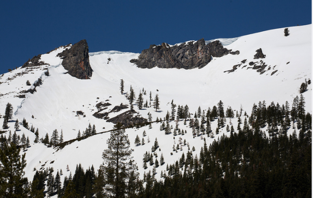
Can you believe it’s already been four years since the beginning of May snowstorm? Alright, if you’re in the Twin Cities you might not remember much about it, as only a half an inch fell. But this snowstorm brought some areas of southeastern Minnesota a foot and a half of snow and also set a new 24 hours May snowfall record in Dodge Center. Read more about this snowstorm from the Minnesota Climatology Office, and then when you are done with that, check out this snow timelapse out of Owatonna captured by fellow meteorologist Kyle Schanus.
_______________________________________________
Shower Chance Today, Then The Doldrums Of May
By D.J. Kayser, filling in for Paul Douglas
The official numbers have come out for April, and – in what should be a surprise to no one – it was a wet and warm month across the region. While we ended the month on a cold note, April became the twentieth month in a row with above average temperatures in the Twin Cities. However, we also saw the twelfth wettest April on record with 4.45” of precipitation falling. This has delayed farmers from getting out into the fields and planting crops this spring.
Fortunately, we are working into a drier pattern over the next several days. After the chance of some afternoon showers and storms today, precipitation chances will be next to zero for the rest of the week into the weekend. Warmer temperatures are also settling back into the region, with highs right around average.
Just remember that it could be worse. Just four years ago, parts of southeast Minnesota were digging out from over a foot of snow that fell over the first few days of May. I’ll certainly take sunny skies and around average temperatures over a May snowstorm any day!
_______________________________________________
Extended Forecast for Minneapolis
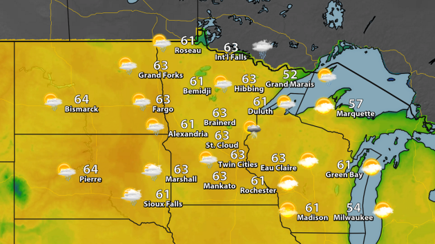
WEDNESDAY: Afternoon rain chance. High 63. Low 45. Chance of precipitation 30%. Wind: SW 5-10 mph.
THURSDAY: Very isolated PM shower possible. Mix of clouds and sun. High 65. Low 42. Chance of precipitation 10%. Wind: N 5-10 mph.
FRIDAY: Fantastic Friday weather! Sunny skies. High 64. Low 44. Chance of precipitation 0%. Wind: N 5-10 mph.
SATURDAY: A few morning clouds, otherwise sunny. High 64. Low 41. Chance of precipitation 0%. Wind: NE 5-10 mph.
SUNDAY: Spring fever continues with blue skies. High 64. Low 44. Chance of precipitation 0%. Wind: NE 5-10 mph.
MONDAY: Mainly sunny. Highs around average. High 65. Low 45. Chance of precipitation 0%. Wind: SE 5-10 mph.
TUESDAY: few more clouds dot the sky. High 66. Low 47. Chance of precipitation 10%. Wind: SE 10-15 mph.
_______________________________________________
This Day in Weather History
May 3rd
1905: A ‘mixed bag of weather’ occurs in Minnesota. Western Minnesota is pelted with hail, while snow falls over the Arrowhead.
_______________________________________________
Average Temperatures & Precipitation for Minneapolis
May 3rd
Average High: 66F (Record: 93F set in 1949)
Average Low: 45F (Record: 18F set in 1967)
Average Precipitation: 0.11″ (Record: 1.72″ set in 1912)
Average Snow: 0.0″ (Record: 0.5″ set in 2013)
________________________________________________
Sunrise/Sunset Times for Minneapolis
May 3rd
Sunrise: 5:59 AM
Sunset: 8:21 PM
*Length Of Day: 14 hours, 22 minutes and 17 seconds
*Daylight Added Since Yesterday: ~2 minutes and 40 seconds
*Next Sunrise At/Before 5:30 AM: May 30th (5:30 AM)
*Next Sunset At/After 8:30 PM: May 11th (8:31 PM)
________________________________________________
Minnesota Weather Outlook
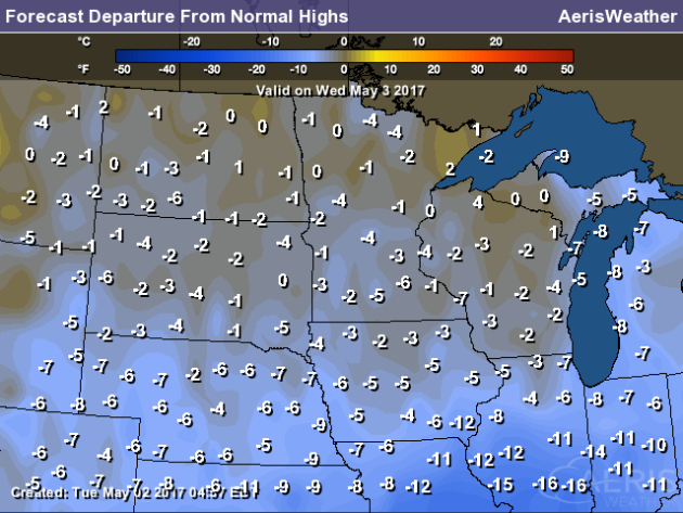
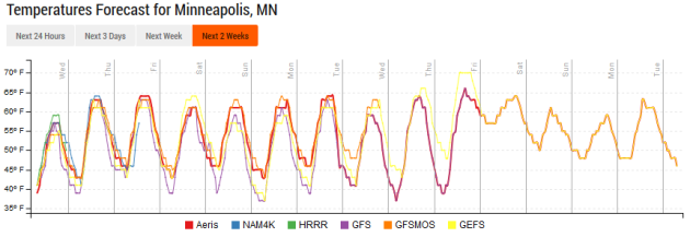
Looking over the next week, highs will stay pretty steady across the metro with lots of sunshine to enjoy! We might see a bit warmer weather towards the end of next week, but that is over a week away. Until then, enjoy a lot of days with highs in the 60s!
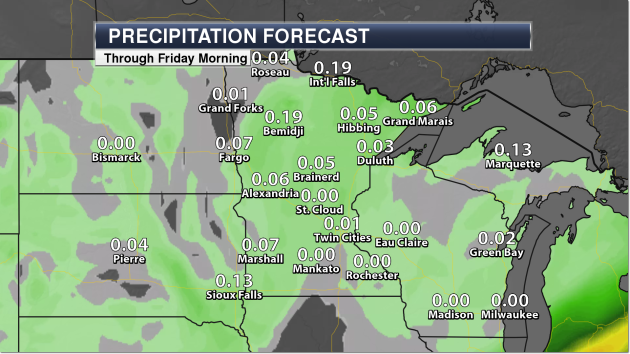
We have a chance of some showers – potentially even a thunderstorm or two – with a front that will be pushing through the state Wednesday. However, it looks like the best chance of seeing rain will be across western and northern Minnesota, with maybe a couple tenths of an inch of precipitation expected.
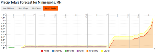
After our chance of some rain Wednesday, we head into an extended period with no rain in the forecast. That should be good news for farmers across the area! Looking in the extended forecast, the next chance of rain doesn’t look to be until the end of next week.
________________________________________________
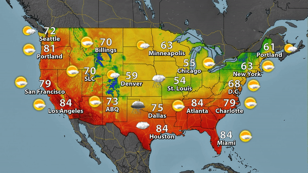
National Weather Outlook
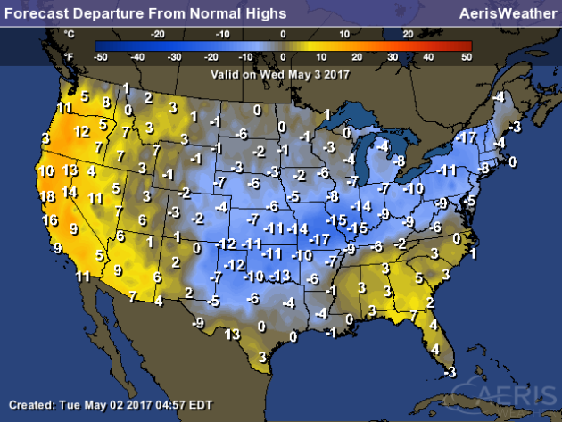
Wednesday Forecast
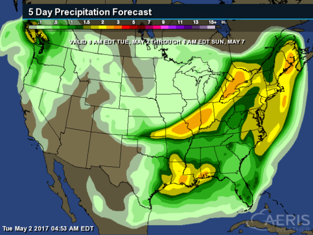
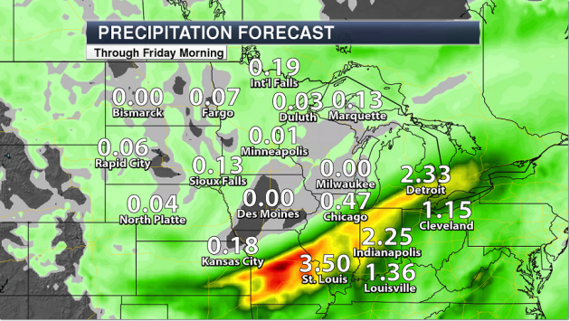
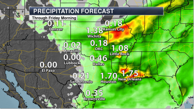
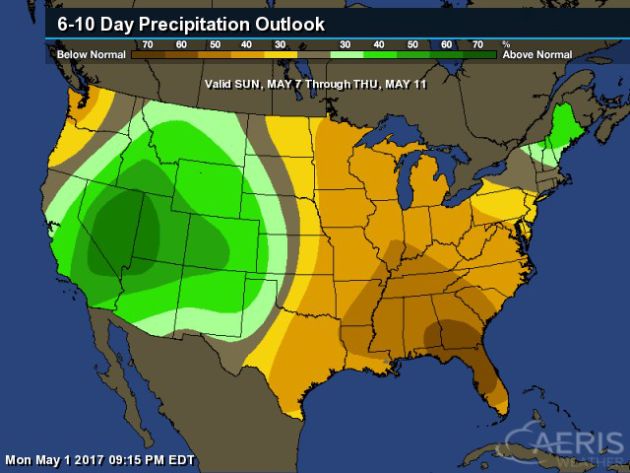
Precipitation Outlook Through Sunday Morning
________________________________________________
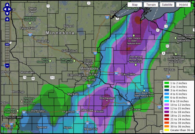
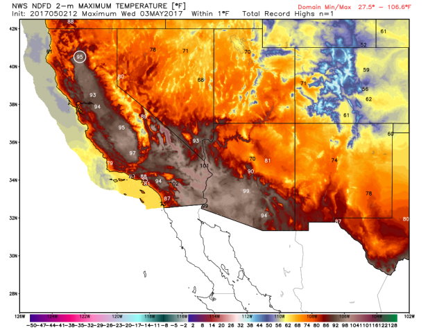
Central U.S. Flooding
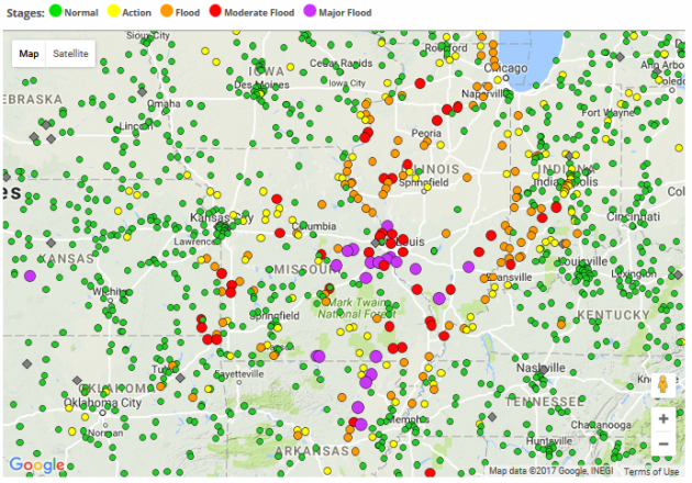
Unfortunately, the last thing that the central U.S. needs is more rain, after river levels continue to be high (and in some spots, record breaking). Already 12 river gauges have seen record flooding from this rain event, after rainfall amounts of over 10″ in spots. Here’s some of the top rainfall totals by state from the rain that fell Friday through Monday:
- 7.95″ – Owensville, IL
- 9.23″ – Huntingburg, IN
- 5.54″ – La Grange, KY
- 10.00″ – Bunkie, LA
- 11.15″ – Houston, MO
- 8.50″ – Savoy, OK
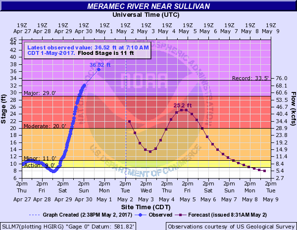
One of the river gauges that saw record flooding is on the Meramec River near Sullivan, MO, which actually stopped recording the river level Monday after surpassing the previous record (set on August 1, 1915) by three feet.
Snow On Satellite
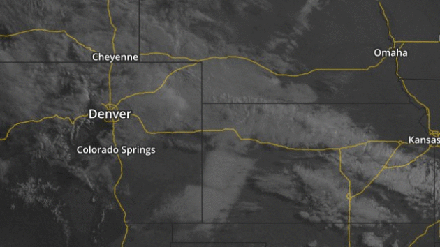
I had to pull out the satellite imagery to be able to see that there was still snow on the ground from this past weekend in parts of Oklahoma, Colorado, Kansas and Nebraska as of early Tuesday morning!
Water-Rich Snowpack In California
May 1st marked the final California snow survey of the season, and it found that there is plenty of water in the current snowpack. More from the California Department of Water Resources: “Today’s manual snow survey by the Department of Water Resources (DWR) at Phillips Station in the Sierra Nevada found a Snow Water Equivalent (SWE) of 27.8 inches, 190 percent of the May 1 long-term average there (14.6 inches). Electronic measurements indicate the water content of the statewide snowpack today is 42.5 inches, 196 percent of the May 1 average. The SWE of the northern Sierra snowpack is 39.9 inches (199 percent of average); the central and southern Sierra readings are 47.1 inches (202 percent of average) and 37.6 inches (180 percent of average), respectively. ” (Photo: California Department of Water Resources)
Trump And The Environment: First 100 Days
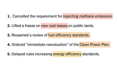
The New York Times tallied it up, and found that 23 environmental rules have either been overturned, are under review, or are in limbo after the first 100 days of President Trump. More from the New York Times: “President Trump, with help from his administration and Republicans in Congress, has reversed course on more than a dozen environmental rules, regulations and other Obama-era policies during his first 100 days in office. Citing federal overreach and burdensome regulations, Mr. Trump has prioritized domestic fossil fuel interests and undone measures aimed at protecting the environment and limiting global warming.”
Drones Used For Atmospheric Research

Drones have been used for many things over the past few years. They’re now also being used to better understand the atmosphere, and to potentially fight climate change. More from Wired: “This March, a truck pulled onto a runway in Oregon, towing a miniature plane for a test flight. At 650 pounds, the plane was too large to be a toy, but too small to fit a pilot. That’s because the ArcticShark isn’t a toy, and it doesn’t need a pilot. It’s a drone. Department of Energy scientists at the Pacific Northwest National Laboratory commissioned its design in order to fly over the Alaska North Slope to take data in the Arctic atmosphere.” (Image: Navmar Applied Sciences Corporation)
________________________________________________
Thanks for checking in and have a great Wednesday! Don’t forget to follow me on Twitter (@dkayserwx) and like me on Facebook (Meteorologist D.J. Kayser)!
– D.J. Kayser

Read Paul’s New Book
Caring for Creation: The Evangelical’s Guide to Climate Change and a Healthy Environment